Posted by Kanoxitu_zh on 22 March 2024 in Chinese (China) (中文(中国大陆)).

求助,今天补充地图的时候网络卡了,结果回来的时候就变成这样了,右键显示的都是[missing “en.javascripts什么的,重启清理数据也没用,只能换其他游览器,有没有什么别的处理方法。 图:https://ibb.co/S0KVzp8
 OpenStreetMap
求助,今天补充地图的时候网络卡了,结果回来的时候就变成这样了,右键显示的都是[missing “en.javascripts什么的,重启清理数据也没用,只能换其他游览器,有没有什么别的处理方法。 图:https://ibb.co/S0KVzp8
Всем привет, занимаюсь маппингом с февраля, а все началось с поста Андрея Ситника в Мастодоне
Поставил себе streetComplete и понеслась
Participants shaded by umbrellas, to protect them from the sun, while collecting fresh geodata with FieldPapers. UP Mindanao Campus, Davao City. Photo shared by UPMinYouthMappers in their SNS post.
While visiting the family down south, I had a chance to join UP Mindanao’s own chapter, UPMin YouthMappers while their College (of Science & Maths) was celebrating Pi Day. The coordinator asked if I have any preference for the name of the activity we had in mind, and I suggested Map-Pi Day.
Bientôt un an (11 mois) que j’use ma souris sur OSM… Et déformation professionnelle oblige, je reportais déjà quelques stations d’épuration suite aux études réalisées au boulot. Puis j’ai commencé à corriger/compléter via Osmose.
Voyant le Calvados (14) quasiment vide de corrections, j’ai cru que quelqu’un avait déjà fait le taf…
Et bien oui ! Mais très peu d’installations dessinées, juste des emprises. Du coup consultation du jeu de données Sandre pour les installations de traitement des eaux usées.
Il existe un bon millier d’installations normandes sur les 22000 au national. Et la plupart n’existent tout simplement pas dans OSM. Bref, je me lance dans un défi qui va me prendre entre 6 mois et un an (plutôt deux en fait…) d’ajout/habillage/actualisation/complétion sur la seule région Normande.
Mais quelle idée…
Sono Squarcia Claudio, socio CAI della sezione di Ascoli Piceno, Mi occupo di sentieristica
Esta entrada recoge información de interés sobre la clasificación jerárquica de la red viaria metropolitana de Málaga y una propuesta para su etiquetado en OpenStreetMap. Los documentos de referencia para la clasificación de la red viaria metropolitana de Málaga son el Plan General de Ordenación Urbana (PGOU), aprobado en julio de 2011, la Ordenanza de Movilidad de la ciudad, aprobada en enero de 2021, y el Plan de Movilidad Urbana Sostenible (PMUS) de Málaga, aprobado en junio de 2021.
El PGOU, en el Título VII del Documento C (PDF 272.4 kB), establece las siguientes categorías de vías en las que se clasifican las calles de la ciudad:
I’ve been kind of bouncing around various projects the past week.
I have tentatively completed sidewalk mapping in Emsworth Borough, and have moved on to adding sidewalks and pedestrian crossings in Avalon. I also did a little revamp of the playground adjacent to the Avalon Elementary School. It turns out that as I was extending the sidewalk along California Avenue, I met up with some previously mapped sidewalk bits, which is nice. Although they have not added a lot of the tags I do, so I will circle back to make this area a little more seamless with what I’ve added to the west.
I’m planning to go through Ben Avon and Emsworth to tag pedestrian crossings and curbs a little more consistently; I had been changing the way I tag things as I went based on new information/methodology.
I got kind of distracted when I realized that Pittsburgh Botanical Garden needed some updating due to their recent renovations. I was able to add the new visitor center and update a lot of the concrete paths, but I have some question marks as to the accuracy of some of the other paths on the property. I will take some good GPX tracks the next time I am there (likely this week). I especially want to see what progress has been made on the feature that is to the southwest of the Lotus Pond. I will also try to acquire a more precise/accurate/official property map from PBG, because the pictoral one on their website is great for ordinary wayfinding, but wholly inadequate in precisely showing where things are.
There’s lots of data stored in OSM about bus stops, but often maps and apps created with OSM data don’t make much use of it (with OsmAnd being the notable exception). For here’s a bus stop as shown by OSM Carto:
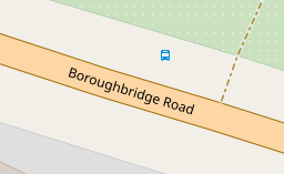
You can see that it’s a bus stop, and you’d be able to see the name if you could zoom in a bit more. However, in OSM there’s actually lots more information. For the map styles that I look after (both web-based raster maps and for Garmin devices) I tried to add a bit more detail. Here’s the result:
Today I decided to introduce a new format for sharing OpenStreetMap-NextGen development progress with the community. I’ll post weekly/bi-weekly updates highlighting changes and the current project status. Since this is the first update, I’ll cover some recent highlights.
You can subscribe to my diary updates on RSS: link.
I’ve begun migrating the settings/preferences section. My goal is to streamline this experience, as I’ve found the current system a bit complex. Surprisingly, many users don’t know it’s possible to change the default editor — I want to make this more obvious.
A new menu on the left of the screenshot (hidden, not yet finished) will provide clear navigation between general, 2FA, OAuth, and other settings.
This page is still work in progress. I intend to add a help text explaining how to contribute to translations and that the translations are made by the community.
As we commemorated International Open Data Day and International Women’s Day, we embarked on a journey to intertwine these essential themes for equitable development. On Saturday, March 9, 2021, amidst a global celebration of Open Data Day, our event in Rwanda stood as a beacon of empowerment, bringing together over 50 enthusiastic participants eager to delve into the world of open data.

Before delving into the event’s highlights, it’s crucial to acknowledge the significance of Open Data Day. With more than 60 events worldwide, it underscores the global community’s commitment to promoting open data’s usage and accessibility. Thanks to the support from key funders, including the Open Knowledge Foundation, these events serve as catalysts for change, fostering collaboration and innovation.
Last quarter, a “getting to know you” survey was made available to the local OpenStreetMap (OSM) communities in the Philippines, to help us better understand the current state of the active contributor base of our community.
The original idea was to run it just for the membership of local YouthMapper Chapters (YMC), but eventually it was made available to anyone who contributes to OSM in the Philippines, here or abroad, regardless of citizenship or affiliations.
I’m sharing my observations from the responses made by the participants who participated in the survey, again, majority of whom comprised of local YMC respondents.
Click on the images, to open them in full resolution in a separate tab.
While 86% of the mappers reported that they are physically in the country, mappers coming from elsewhere at 14% was bigger than I expected.

..
The YouthMappers UFRJ (Rio de Janeiro, Brasil) completed one year on March 14th, 2024.
And to celebrate this special date, we interviewed Dr. Rogério Luís R. Borba, analyst at the IBGE Foundation and manager of the Brazilian Geospatial Data Directory (“Diretório Brasileiro de Dados Geoespaciais, DBDG) of the Brazilian National Spatial Data Infrastructure (“Infraestrutura Nacional de Dados Geoespaciais”, INDE).
🎥 Watch on IVIDES.org’s YouTube channel.
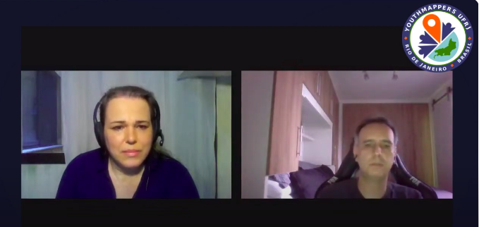
Rogério talked to us about the importance of open data and how the collaborative mapping can helps Brazil in the production of official cartographic data. The interview was conducted by Dr. Raquel Dezidério Souto and all details can be found at:
O capítulo YouthMappers UFRJ (Rio de Janeiro, Brasil) completou, no dia 14 de março de 2024, 1 ano de registro internacional.
Para comemorar esta data especial, entrevistamos o Dr. Rogério Luís R. Borba, analista da Fundação IBGE e gerente do Diretório Brasileiro de Dados Geoespaciais (DBDG) da Infraestrutura Nacional de Dados Espaciais (INDE).
🎥 Assista no canal do IVIDES no YouTube.
Rogério conversou conosco sobre a importância dos dados abertos e como os mapeamentos colaborativos podem auxiliar o Brasil na produção de dados cartográficos. A entrevista foi conduzida pela Dra. Raquel Dezidério Souto e os detalhes podem ser conhecidos em:
Happy Burger 11309 Midlothian Turnpike Richmond, VA 23235
As part of my commitment to OpenStreetMap-NextGen migration, I undertook a comprehensive security review of the existing OpenStreetMap website. I followed the principles of coordinated vulnerability disclosure, working directly with the maintainers to responsibly report my findings. Today, I’m making the details of this process public and verifying the status of the fixes.
Authorization tokens (oauth, session, user tokens) are stored in plain text. Read access to the database allows full impersonation of any user.
Status as of 2024-03-15: Partially vulnerable (oauth still depends on plain text storage)
NextGen Codebase Status: Fixed (all authorization tokens and credentials are hashed or encrypted for secure storage)
The tokens used to ensure the authenticity of email replies are too short (24-bit), making them susceptible to brute-force attacks. An attacker could potentially guess the token and impersonate a legitimate user in email conversations. This vulnerability is especially dangerous if the attacker already has access to a conversation’s metadata (allowing for complete security bypass).
Status as of 2024-03-15: Fixed (now with 48-bit security)
NextGen Codebase Status: Fixed (128 or 256-bit security; undecided)
Apparently, OSM in Vietnam is in a very poor condition. And one of the reasons would be the absence of several nature reserve areas, even compared to the two neighboring Indochinese brothers, Laos and Cambodia. Despite the fact that the Department of Forestry has published a document stating that there are 34 national parks and 56 nature reserves, until now (15 March) only half of them have been mapped to OSM.
Here’s the list:
Official “Nature Reserve” title refers to the fact that these areas have their own management board (ban quản lý) and is usually a division of the provincial departments of agriculture and rural development (Sở Nông nghiệp và Phát triển Nông thôn). These includes:
Please also share/blast in your socials/network :)
—— 👂👀 Have you heard? 📢 We have launched 🚀 the #OSMFMembershipCampaign 2024!
Help us grow and diversify #OSMF members in regions 🌍🌏🌎 where there are no or very few OSMF members! You can support! 🎯 https://blog.openstreetmap.org/2024/03/12/call-to-action-help-us-grow-and-diversify-osmf-membership/
Join ✍️https://supporting.openstreetmap.org/#Membership-Categories