Users' Diaries

Recent diary entries

Posted by mayanaut on 7 March 2024 in English.

Added sidewalks south of Center Avenue between Hazelwood and Hiland, north of ORB/PA-65. Connected sidewalk to previous additions from Ben Avon.

I plan to extend coverage north of Center Avenue within Emsworth, and south of ORB/PA-65.

Added some parking lots here and there where most obvious, and cleaned up the area around Camp Horne Road & ORB intersection. This area could likely use some more work.

Realigned buildings here and there based on updated aerial photography. Might make another pass because there are quite a few that seem to be several meters out of alignment. I’ll have to check the original data these were derived from, but at least so far it seems that the PEMA imagery is the most accurate and precise available. I’ve cross-checked several notable points against the Allegheny County GIS viewer to confirm alignment to the best of my ability for now.

Location: 40,512, -80,098
Posted by b-unicycling on 7 March 2024 in English.

(All images via WikimediaCommons)

So, I went on a little outing with a friend to look at some historic/ folkloristic sites that I hadn’t been to before. One of them was an old monastic site where there is still a working church with a holy well (place_of_worship=holy_well) and high cross (historic=high_cross) nearby. When we went to the holy well/ high cross site, I was delighted to see that the site also had a rag tree which hadn’t been recorded on the government’s Historic Environment Viewer. rag tree at St Laserian's Well Now, there could be several reasons for that which I won’t go into, but it reminded me that rag trees were something I had wanted to map, but of course, there was no tagging scheme.

I had mapped some previously using just natural=tree with various other tags, but I thought I needed a tagging scheme that was applicable to other countries and cultures as well.

See full entry

Location: Oldleighlin, Old Leighlin ED, The Municipal District of Muinebeag, County Carlow, Leinster, Ireland

¡Hola a todos! Quiero compartir con ustedes algunos insights y avances del proyecto en el que he estado colaborando, específicamente en la validación de datos. TASK

La calidad de los datos en proyectos de gestión de riesgos es fundamental para garantizar la fiabilidad y precisión de la información utilizada en la toma de decisiones. ¡Pero también es importante recordar que los errores son oportunidades de aprendizaje!

Estos son algunos de los mensajes que he enviado en el task a las personas con base a los errores de mapeo que he encontrado:

En primer lugar un mensaje de agradecimiento: ¡Gracias a todos por su contribución a este proyecto! ¡Sigamos trabajando juntos en el mapeo colaborativo!

Ahora si:

📝 He agregado construcciones faltantes: Tip: Puedes poner imágenes diferentes para detectar todas las construcciones, sin embargo, recuerda siempre dibujar sobre la capa solicitada.

📝 He modificado la etiqueta de una vía: Recuerda que las unclassified las empleamos para las vías que conectan centros poblados.

📝 He modificado la etiqueta de una vía: Recuerda que empleamos la etiqueta service para vías que conectan a un lugar en específico como casas, industrias, negocios o barrios con acceso privado.

📝 He modificado la etiqueta de una vía: Recuerda que la etiqueta residencial la empleamos para vías en las ciudades o centros poblados.

📝 He encontrado que algunas construcciones compartían nodos: Te recomiendo emplear en JOSM el plug-in Building y presionar la letra Ctrl en tu teclado para evitar que las construcciones se peguen.

📝 He encontrado que algunas construcciones eran muy pequeñas: Esto suele pasar cuando los techos tienen color diferente. Te recomiendo emplear otras imágenes como guía.

Velar por el aprendizaje de los nuevos mapeadores es velar también por la calidad del mapa. ¡Ay que seguir apoyando a los nuevos maperos para seguir mejorando juntos!

See full entry

Location: Orienco, Parroquia Pacayacu, Lago Agrio, Sucumbíos, Ecuador

Today marks a milestone in the development of OpenStreetMap NextGen. After months of rigorous development, I conducted the 1st OpenStreetMap NextGen performance benchmark, a crucial step towards realizing the vision of a more robust, efficient, and user-friendly OpenStreetMap.

The focus of today’s benchmark was on evaluating static and unauthenticated requests. Since this core functionality is unlikely to change significantly during future development, it’s the perfect time to test it.

Future benchmarks will focus on timing authenticated requests as well as API 0.6.

What was measured

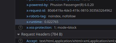
The benchmark analyzed request processing speed, excluding network and client latency. Both osm-ruby and osm-ng support the X-Runtime response header, which tracks how long it takes to process a request and generate a response.

X-Runtime header in browser inspect tools

Here’s a general breakdown of a typical static request processing:

See full entry

Posted by spwoodcock on 5 March 2024 in English. Last updated on 6 March 2024.

See pt1 of this series here.

See pt2 of this series here.

A Long Overdue Release

The goal with the Field Mapping Tasking Manager (FMTM) was to adopt an agile development style, making a new release around once per month.

3 months have passed since the last blog post and there was no FMTM release in between!

What gives??

Well, the team has been working extremely hard simplifying usage of FMTM and making it much more usable.

It’s been hard to find a good point to stabilise a release due to so many great and rapidly developed updates!

From this release onwards we plan to follow through with a new version increment every month. Look out for version 2024.4.0 next month.

Public Beta Now Live

  • The main goal we have been working towards is releasing a public beta this month.
  • The public beta for FMTM is now live on https://fmtm.hotosm.org
  • The idea to to have the public test out it’s functionalities & definitely break a thing or two!
  • With your valuable feedback we want to make FMTM the best it can possibly be 🙏

See full entry

Location: Patte d'Oie, Ouagadougou, Kadiogo, Centre, Burkina Faso
Posted by mayanaut on 5 March 2024 in English.

Started working on extending sidewalk mapping coverage into Emsworth Borough. I’m working much the same way as I did for Ben Avon, mapping sidewalks using a combination of aerial imagery, street-level photographs (Bing, PEMA, Esri, as well as my own), and in-person survey.

I was somewhat surprised to see that a footpath I have used numerous times going back many years was unmapped, so I added it (marked on the associated map).

I am trying how best to approach the area of Memorial Field (adjacent to Ohio River Boulevard / PA-65). The area currently marked shows as a football field, but the actual usage of the field is also a baseball diamond seasonally. In addition the area is shaped and sized differently than currently shown. Also, there are footpaths around it that are somewhat challenging to see on aerial imagery, so I suspect I will have to do some in-person GPS tracking to get better data. I am debating whether or not to map the pedestrian tunnel that passes beneath ORB/PA-65, as in the past I have been admonished that it is illegal to use. But it’s not physically blocked, nor are there posted signs indicating the access status. I just don’t want someone to wander through it and get into trouble, so maybe I’ll map it and tag it private or something to discourage public use until I can confirm.

I will probably bounce around between sidewalks and other features as I come across them.

Location: Emsworth, Allegheny County, Pennsylvania, United States
Posted by Zkir on 5 March 2024 in Russian (Русский).

OSM в руках синьки и норкоманов – это несомненный успех.

Если по существу вопроса – если раньше мы жили в гипо-информационном обществе, то теперь живем в гипер-информационном. Что-то спрятать не получится, придется привыкать.

С другой стороны, когда я на свой майнкрафт-сервер приделал онлайн карту, тоже далеко не все игроки обрадовались.

OSM in the hands of alcoholics and drug addicts is an undoubted success!

Previously we lived in a hypo-information society, now we live in a hyper-information society. It is not possible to hide something, you’ll have to get used to it.

On the other hand, when I attached an online map to my Minecraft server, not all players were happy.

https://community.openstreetmap.org/t/proposal-to-add-the-emoji-as-a-reaction/107167/1

this thread which is even has 2 DWG participants started off as a joke but has turned into coordinated harassment and trolling, they even praise “skillful trolling” I am going to let people read this for themselves. This is the backbone of OSM everybody.

Posted by mayanaut on 4 March 2024 in English.

I’ve begun to add sidewalks in Swissvale Borough.

This is my current methodology (just putting this somewhere so I can reference it later, and adapt to new information/methodology when necessary):

  1. add longest section of sidewalk possible (using clearest aerial imagery available, when in doubt, crosscheck with others; using PEMA, Esri, Bing for the most part), tag surface and smoothness where appropriate.
  2. add pedestrian crossing across intersecting ways, tag surface and markings.
  3. add crossing for intersecting ways (when prompted), tag surface and markings.
  4. tag all corners appropriately (curb height, wheelchair access).
  5. verify the above using street-level imagery and in-person surveys when possible.
  6. change tag for adjacent streets to sidewalk=separate to indicate that the sidewalk is mapped separately.
Location: Swissvale, Allegheny County, Pennsylvania, 15218, United States
Posted by mayanaut on 4 March 2024 in English.

I’ve lately been doing some small fixes here and there, just trying to tie up some loose ends. This has included some in-person surveys of a few areas, which has raised as many (or more!) questions than it has answered. I still have a long list of other surveys I wish to conduct as my schedule allows. With the weather (generally) getting warmer every week, I feel like these will get more frequent.

I’ve added a few stop signs, but have paused doing that because I’m not entirely sure I was doing it correctly or the preferred way.

I’ve added some bus stops, but have paused doing that in a comprehensive way because I want to figure out how to assign them properly to routes / relations. That’s a whole new dimension of OSM that I don’t have a good grasp of yet, and need to do further research.

I think I’m going to branch out to other areas to work on sidewalks, because adding them is really satisfying. I’ve already gotten feedback from an IRL friend who uses one of the OSM-based apps that they appreciate seeing ‘new’ sidewalks popping up.

Moin liebe Community, ab dem 20.03.2024 bis zum 01.04.2024 werde ich mich in Nienburg aufhalten. Folgende Hinweise werde ich dann bearbeiten:

Hinweis 3983162 - Fichtestraße 32, Nienburg

Hinweis 3678091 - Lemkerstr. 3d, Nienburg

Hinweis 3208133 - Verdener Landstr. 179, Nienburg

Hinweis 3955130 - Krähe/Langendamm

Ebenfalls werde ich mit StreetComplete arbeiten.

Solltet Ihr noch irgendwelche Hinweise haben, dann schreibt mir gerne hier auf OSM.

Habt einen angenehmen Tag, Daniel (DanieCeBus)

Location: Stadtteil Nienburg, Nienburg/Weser, Landkreis Nienburg/Weser, Niedersachsen, 31582, Deutschland