 OpenStreetMap

[broken link]
Users' Diaries
Recent diary entries

Wie kann ich während der Navigation nur die Erdgas-Tankstellen anzeigen lassen? Gruß, Thomas
Posted by seeergiofdez on 15 June 2023 in Spanish (Español).
Last updated on 30 June 2023.
En este post adjunto todos los recursos que me han sido útiles para la creación de rutas de autobuses del CRTM. Muchos de ellos han sido creados por otros usuarios, limitandome a crear una “norma general” para hacer todas las rutas más regulares, y con las mismas etiquetas que otras del mismo estilo.
Conocimiento general
Una ruta de autobus en OpenStreetMap se compondrá de tres cosas:
- El recorrido,
- La ubicación de parada dentro del recorrido
- La plataforma de parada (marquesinas)
Nodos
Ubicación de parada

Se colocará en aquellos puntos del recorrido (calles, avenidas…) donde el autobús hace parada o tiene establecida parada en su itinerario.
bus=yes
public_transport=stop_position
Plataforma de parada

Along Pennsylvania’s freeways, there are emergency detour routes that allows travelers to bypass traffic accidents, inclement weather, and other road closures. Colors commonly used are black, blue, green, orange, and red. The detours are perhaps one of the least mapped features across Pennsylvania.
The best sources to consult are street-level photos from Mapillary and Bing Maps to establish which highways the particular route follows. I also recommend having a map nearby and to use colored pencils to mark the detour on the map.
Tagging the colored detours is quite easy using iD. Simply create a new Relation -> Route Features -> Detour Route.
Under Name, type in the name to be used, for example Orange Detour (I 79 Exits 121-130). Colors are used multiple times, so it is necessary to differentiate between them by including the ref for the highway being detoured and also the exit numbers that are being bypassed.
The Route Number in this case is Orange.
Because these detours are bidirectional, the from and to tags aren’t necessary.
The Colour tag would be orange.
Since I-79 is being detoured in this example, the Detour tag would be I 79.
Don’t forget to tag the directional role of the relation if the road being tagged is one way.
To make tagging easier, consult the OSM Wiki under the Detour page.
I have also published a YouTube video showing the best way of how to tag the relation.
I hope y’all find the resources helpful for adding the emergency detour routes across Pennsylvania.

Cross-posting from HOTOSM blog.
As we dive into the second half of 2023, we are thrilled to share the progress made by HOT and the Community Team in leveraging OSM data for informed decision making.
Hello! I’m Rubén Martín, HOT’s Community Strategist and Research Lead, and in this post, I aim to highlight our recent achievements and extend an invitation to OSM communities, contributors, organizations, and individuals interested in OSM data to collaborate with us on analysis and research endeavors.
Focusing on Actionable Insights: A Data-Driven Approach
At HOT, our data approach goes beyond satisfying curiosity; we strive to generate actionable insights that enable us to better support the communities utilizing Open Mapping to address local needs. Over the past months we have, together with our dedicated Data and Analysis Intern, Caleb Fagunloye (along with support from Benni Herfort at HeiGIT) made significant progress in two key areas outlined below:
-
Better understand OSM Contributor Data and validate assumptions around contributors decline.
-
Explore and experiment how to make OSM Data more accessible to non-technical people.
OSM Contributions Decline
Sto cercando una soluzione
Come vedete, i vai sono taggati waterway:steam o waterway:ditch anche se lì dentro acqua non ne scorre mai. Il loro inserimento e denominazione deriva dalla copiatura da un noto libro di itinerari alpinistici. Ma non si tagga per il rendering.
Sto pensando di ritaggare tutto con valley, che al momento è quello che si avvicina di più alla morfologia. Il problema non è di facile soluzione perchè si tratta di vallette molto strette e ripide. Che fare?
Ogni suggerimento sull’argomento è benvenuto
anphucspa chuyên massage trị liệu

Making plans, so checking on the many sources for good hikes in an area. First, because it’s Six Rivers National Forest (mainly), I glance over the Forest Service topographic maps. There’s not a lot of trails showing on there in the area, but there’s three heading up to a selection of lookouts. There’s also a bunch of quarter mile spurs. Why? What sense do these make?
I check the USGS, but these are generally older and the information was supplied by the Forest Service anyway.
For the basic well known things, check AllTrails. It says you can cross country up Black Lassic. (I knew that already.) A community content tab appeared a few years back and you can find some good things here sometimes, but it’s always buried in a load of strange. There’s a bunch of strange in this area. Strange strange. Usually there’s a lot of long bike rides, but not here. Someone has apparently hiked the river underneath the reservoir. That’s fancy.
Hiking Project will often have a different set of trails. Actually, I find this a much more useable app for finding trails. Some of that is because even the free version will let you easily have the whole state downloaded. (It’s funding by outdoor venders and if they encourage you to wear out your gear, you’ll buy more gear.) Unfortunately it only has the nearby National Recreation Trail I already know about.
Posted by AngocA on 13 June 2023 in Spanish (Español).
Last updated on 14 June 2023.

Este es un artículo que describe la actividad que se realizó entre mayo y junio de 2023, llamada Mapea por Mosquera, donde se mapeó en detalle el centro del municipio de Mosquera, Cundinamarca, Colombia.
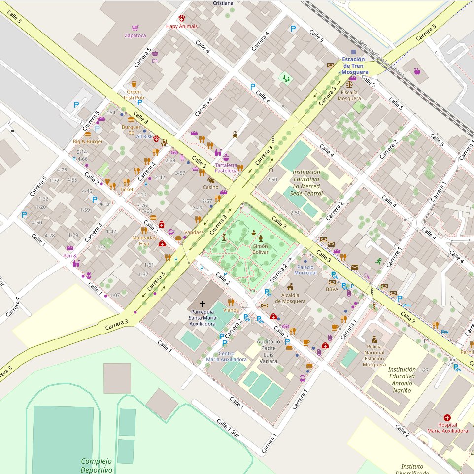
Involucrar a la comunidad
Este evento buscó integrar a la comunidad, enviando invitaciones a varios grupos locales, publicando invitaciones tanto físicas como por redes sociales, y haciendo referencia a la alcaldía del municipio (este último usa OpenStreetMap en su página web.)
Por otro lado, se imprimió un sticker para pegarse en los establecimientos detallaban en el mapa. La pegatina tenía un código QR a un enlace acortado (dub.sh) que apuntaba a una subpágina del wiki de la actividad: osm.wiki/ES:Edici%C3%B3n_organizada/Actividades/Mapea_por_Mosquera/Bienvenido
Esto permitía que las calcomanías hicieran publicidad sobre el evento días después de terminado, y que las personas supieran qué se había hecho.
Posted by adreamy on 13 June 2023 in Korean (한국어).
Last updated on 15 June 2023.

먼저, 흔히 광장과 같은 ‘보행자 지역’을 제대로 태그하는 것이 왜 중요한가 하면,…
그런 곳을 ‘영역’(area=yes)로만 태그하면 그 곳을 길찾기(routing), 길 안내(navigating)에서 길을 이어주지를 못 합니다.
따라서, ‘보행자 지역’을 ‘영역’으로 지정함과 동시에 ‘highway=pedestrian’으로 태그하면 영역의 바깥선을 따라 길을 이어주게 됩니다.
가장 좋은 것은 영역으로 지정하되 ‘area=yes’가 아니라 ‘area:highway=pedestrian’으로 하고 동시에 ‘highway=pedestrian’ 하는 것입니다.
참고로 OSM 위키에서는 ‘highway=pedestrian’ + ‘area=yes’ 사용을 추천하고 있습니다.
길찾기가 제대로 되는 것을 확인했습니다.
Posted by LMResearcher on 12 June 2023 in English.
A virtual discussion on the subject “Structure and Governance of a Local OSM Community” held on March 23, 2023 was the third of the Humanitarian OpenStreetMap Team (HOT) Community Working Group Peer-to-Peer Learning Series aimed at supporting the new OSM chapters in Saint Lucia and Dominica. This session was attended by 18 members of the OSM Community from across the globe. The session was guided by some key questions on the subject; below are the major take-aways from this discussion.
What are the different roles that people can play in a local OpenStreetMap community?
The roles and responsibilities were discussed as a precursor to the discussion on the structure. It is important to identify what the community should consist of ahead of assessing how it is organized. The most common roles highlighted were mapper and trainer. However, roles such as sponsor, social media marketer, community coordinator, communications and project manager. Communications include posting on social media, blogs and even responding to questions on the forum.
Though I am not a sophisticated mapper, I really enjoy updating the local POIs in my area. Here’s the story of one of adventures that I wrote for my town’s weekly newsletter, “Enthusiasms:
Posted by Barro on 12 June 2023 in Finnish (Suomi).
Last updated on 25 June 2023.
Loin joskus yli 10 vuotta sitten OpenStreetMap-tunnuksen ja tein silloin yhden päivityksen. Silloin ei oma halvalla hankittu ainoa älypuhelimeni oikein soveltunut käytettävyytensä puolesta OpenStreetMapin datan keräämiseen ja muutenkin työkalut tällöin oli käytettävyysmielessä vähän mitä sattuu.
Sitten pari vuotta sitten tuli vastaan tilanne, jossa yritin keksiä, että mihin pysäköidä pyörä Helsingin keskusta-alueella lähelle määränpäätä siten, että sen saisi järkevästi rungosta lukittua. Kun tajusin, että tämän datan voisi olla hyvä löytyä OpenStreetMapista, niin aloitin sitten oman projektin pyöräparkkien kartoittamiseksi alueilta, joilla liikun.
Valitaan mitä kartoitetaan
OpenStreetMap on loputon suo sen suhteen, että mitä kaikkea siinä voi kartoittaa. Päätin itse rajata oman panokseni koskemaan noin suunnilleen seuraavia tilanteita:
- Lisätään kartalle pääasiassa runkolukittavia pyörätelineitä. Perinteiset kiekonväännintyyppiset helposti siirrettävät telineet, joita löytyy ripoteltuna sieltä täältä saa jäädä lisäämättä.
- Poikkeuksena tilanteet, jossa kyseinen teline on jo kartalla ja se tarvitsee tietojen päivitystä. Tai jos näitä kiekonväännintyyppisiä telineitä on paljon yhdessä paikkaa.
Nämä rajaukset siksi, että se vähentää työmäärääni ja ylläpitää paremmin mielenkiintoa OpenStreetMapin päivittämiseen. Osaksi tämä on myös arvovalintakysymys, sillä jos siinä on edes teoreettinen mahdollisuus, että tuomalla OpenStreetMapiin esiin hyviä ratkaisuja yli huonojen, joku voi hyödyntää tätä tietoa omassa päätöksenteossaan. Käytän myös itse aina välillä kartalle lisäämääni tietoa hyväkseni. Omassa käytössä luonnollisesti suosin sitä, etten joutuisi kärsimään huonolaatuisista ratkaisuista.
Kan se at der er tilføjet en cykel barrierer midt på Stoholmvej 7840 Nørre Søby. Har kigget rundt på nettet og kan ikke finde nogle steder at vejen nu er spærret - En fejl eller ?
Last week, the climate officer from my local county council reached out to me to see whether “we” (i.e. OSM) had locations for drinking_water:refill mapped. (She used to be the heritage officer, so she knows well what I do).
After some confusion about what she meant (I thought holy wells…), I found that there was one mapped as amenity=drinking_water, but without the drinking_water:refill tag.
I presume the reason she is asking is that the council wants to install more, but doesn’t know where there are already some.
Some more research revealed that there are at least two providers in Ireland, both use GoogleMaps, one not very successfully: EcoFil. In agreement with the OpenStreetMap Ireland board, I sent emails to both companies to ask whether they could make their datasets open giving the county council analysis as one example for the usefulness of #OpenData in this case, pointing out that they could also benefit from a complete dataset.
(overpass-turbo for Republic of Ireland)


😍

Introduction
The purpose of this document is to explore the possibilities of the Segment Anything Model (SAM) Segment Anything developed by Meta in OpenStreetMap mapping. SAM is a promising model in the field of image segmentation, and its potential application to fAIr could enable the tracing of various features on maps. This document provides an overview of SAM’s working mechanism, test cases conducted with SAM, and two potential integration ideas for utilizing SAM
SAM Working Mechanism
SAM operates directly on images and generates individual masks based on the training datasets used during model training. Unlike object detection models, SAM focuses on segmenting all elements present in an image, regardless of their nature, based on texture, color, and points of difference from the background and several others can be found on their research doc

Advantages of SAM for fAIr and OSM Mapping
Posted by ZeLonewolf on 7 June 2023 in English.

Thanks to planetiler, it is possible to run your own OpenMapTiles vector tile server on Amazon Web Services (AWS) for less than $20 per month. This guide describes the process that I used to stand up tile.ourmap.us for the OSM Americana project, and it does require some knowledge of AWS. However, I taught myself how to use AWS, and I’ve tried to include enough details here to assist someone trying to stand up their own tileserver.
There are many different ways to do this, including different storage, hosting, and tileserver setups. This is just one option that worked for me for what I was trying to do.
The architecture
This setup in this guide assumes that infrequent planet updates is acceptable for your use case. So, we will spin up a powerful server to update the map only when needed, and use a low-powered server to run the HTTPS tile server on an ongoing basis. If you require more frequent map updates, this is probably not a good solution and you should consider dedicated hardware. The main advantage of AWS in this use case is the ability to rent a high-performance computer for a short period of time.
Additionally, this setup assumes that you already own a domain name that you can use to point to the tile server. If you don’t have one, you can purchase one on Google Domains for $12 per year.
In our setup, we will render a planet to a large file in .mbtiles format, and use tileserver-gl to serve that .mbtiles as an HTTPS server.
Another advantage of using AWS is that they host a locally-mirrored copy of the planet file. Therefore, it is posible to download the planet in a few minutes, which reduces the amount of time that we have to rent that high-powered server to render the planet.
When we say “render the planet,” it means the following operation:

The startling regularity of these posts amazes even me. Today I went for a bit of a walk with my brother Joe’s dog, Pumpkin. It’s an embarrassing name. Joe and his kids seem to shorten it to Pumpki. My mouth and memory struggle with that so I have been trying Pumki, Pumpi and Punki. Pumpkin does not respond to anything I say so I have tended toward Dog or Hey You. I resorted to buying a packet of dog treats in a mildly successful effort to be noticed.
OSMAnd has been very handy as usual to find my way. I found a broken bit on the map and tried to fix it but I don’t really know what I’m doing. I did record my track, hopefully that’ll help someone.

For some months now, Champs-Libres has been working for the NMBS/SNCB, the national railway company of Belgium, for reusing OSM data of Belgian stations. The NMBS/SNCB has an interest in OSM data for improving some services to travelers regarding accessibility data, especially for bicycles. Have a look at the wiki page for more insights!
The first diary entry was about the basic data on the Belgian stations and platforms. In this second diary post, we’ll show how to map access to the railway platforms.
What is the access to a railway platform?
A traveler, with or without a bike, can walk to/leave a platform by several means of access. We’ll call these “access objects”, which can all be mapped in OSM. Here is how to map these access objects and how they are mapped in the Belgian train stations. We hereby focus on travelers walking through stations with their bikes.
Elevators
Elevators are represented in OSM with a single node (most of the time) and the tag highway=elevator. The following overpass query https://overpass-turbo.eu/s/1pm1 gives 90 elevators that are strictly to and from the platforms. They are mostly found in the larger train stations. However, we noticed that some elevators were not identified by this query because they were slightly outside of the platform area. This should be corrected in most cases.