OpenStreetMap logo OpenStreetMap

Users' Diaries

Recent diary entries

Posted by tordans on 24 June 2023 in English. Last updated on 25 June 2023.

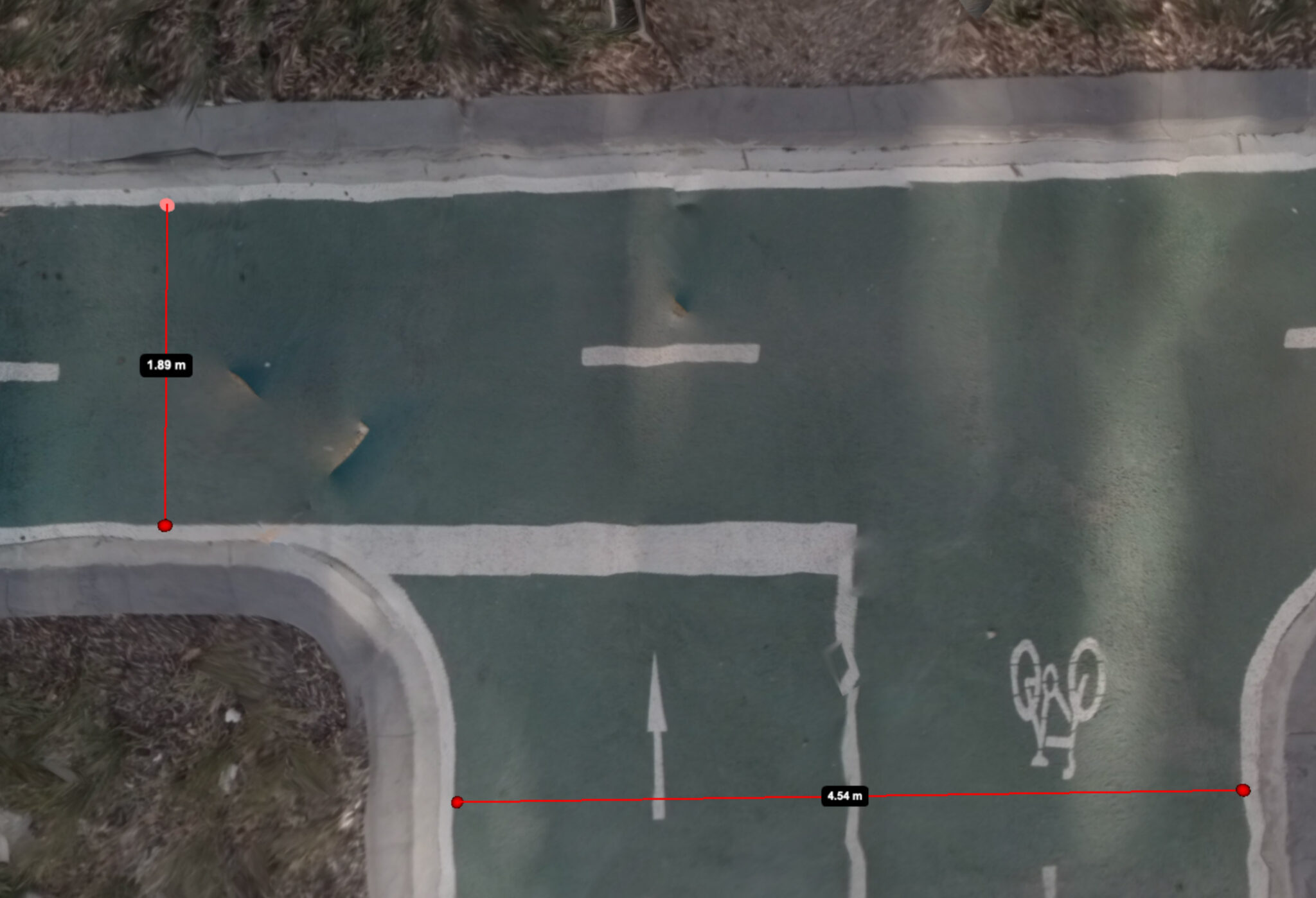
Generated aerial image of a bike lanes with digital distance measurements

Image Source: Jake Coppinger

Companies like Mapillary and Kartaview have played a significant role in advancing OpenStreetMap (OSM) and enabling detailed mapping efforts, particularly in urban areas. While 360° street-level images have been crucial for capturing high-quality data, there is a growing need for a scalable solution that leverages the power of aerial imagery to further enhance community mapping. In this blog post, we delve into the potential of aerial imaging and its implications for OSM mapping. Interestingly, emerging companies in the 360° imagery space, such as Mapillio (Commercial) and GeoViso (Open Source), may view this as an opportunity to add a unique selling point to their portfolio. The process of generating detailed aerial-like imagery for specific smaller areas not only benefits OSM mapping but also proves highly valuable for city planners involved in intersection redesigns or the addition of bike paths to streets.

See full entry

Posted by Mapping_Madison on 23 June 2023 in English.

I am now going to start working In Franklin Township. Hopefully I can finish at least the Forests, Farmlands, Cities, and possibly some more rural residential areas.

I will start in Chilo, and work my way across the Ohio River. once finished, I will then move along the borders of Franklin Township and I will finish Felicity. After that, I will work on the forests and farms in between Felicity and the borders of the Township.

Chilo will be tackled after I finish the forests and farmlands near it, and this will probably take a couple more edits, not too many though, hopefully.

June has always been a hectic month for the LGBT community as several PRIDE celebrations and rainbow-themed collaterals are all over the internet.

For this year, RainbOSM (a safe space for LGBT and allies on OpenStreetMap), MapBeks and the Open Mapping Hub Asia Pacific with HOT thought on casually collaborating in releasing some LGBT tagging information out of the closet (JK!).

This is essentially important as LGBT spaces and features are part of the real world and through OpenStreetMap we are able to digitally make them existent.

See full entry

Posted by iriman on 23 June 2023 in Persian (فارسی). Last updated on 13 September 2024.

مدتی است که پخت نان در تعدادی از نانوایی‌های استان مرکزی به پخت با آرد کامل ارتقا پیدا کرده است به این امید که به‌مرور بازگردیم به مصرف نان‌های سالم و خوش‌عطر و بویی که هنوز از خاطرهٔ بزرگ‌ترهایمان نرفته است!

عکس نان کامل

آرد کامل چیست؟

طبق تعریفی که در استاندارد ملی ایران به شمارهٔ ۱۰۳ آمده، آرد کامل یا آرد تمامْ‌دانه که در انگلیسی به آن whole flour یا whole grain flour می‌گویند آردی است که از تمامی اجزای دانهٔ گندم (اندوسپرم، سبوس و جوانه) پس از پوست‌گیری اولیه تهیه می‌شود و دارای ویژگی‌های مندرج در این استاندارد است. میزان سبوس‌گیری آن از ۲% تا کمتر از ۶% است.

این نانوایی‌ها کجا هستند؟

ادارهٔ کل غله و خدمات بازرگانی استان مرکزی فهرستی از نانوایی‌های با آرد کامل را منتشر کرده که از منوی نان کامل در وبسایتش می‌توانید ببینید. در برخی استان‌های دیگر نیز این نانوایی‌ها کمابیش وجود دارند که در منابع رسمی یا خبری مرتبط اطلاع‌رسانی شده.

روی نقشه؟

See full entry

Websites URLs in many cases are not stone steady, hence monitoring their status can be wortly. Here is how to do it in a semi-automatic flavour:
* download POIs,
* ask their URL a reply
* store unresponsive websites OSM objects

Let’s start gathering a list of shops with website tag. This Overpass example query yelds a CSV with essential data separated by comma. You can see the result in Overpass data window.

To automate process (bash), we need the Overpass query string and provide it as an argument of wget command. In “Export”, simply copy the link you find in “raw data directly from Overpass API”, then (remembering to enclose link in double quotes)


$ wget -O mylist.csv "http://overpass-api.de/api/interpreter?data=%5Bout%3Acsvblablablabla"

at this point mylist.csv contains something like:


@id,@type,name,website
194581793,node,Sirene Blu,http://www.sireneblu.it/   
228109189,node,Ecoscaligera,http://www.ecoscaligera.com/   
[ETC, ETC]   

Now we need to scan each line of mylist.csv and wait for an http reply (ie: 200 OK, 300 moved, etc). It’s done running the following code:


#! /bin/bash
while IFS="," read -r OSMid OSMtype OSMname url
do
  REPLY=`curl --silent --head $url | awk '/^HTTP/{print $url}'`
  echo "https://www.openstreetmap.org/"$OSMtype/$OSMid","$REPLY
done < <(tail -n +2 mylist.csv)

Let’s call the above script replies.sh. The output could be something like:


$ ./replies.sh 
https://www.openstreetmap.org/node/287058106,HTTP/1.1 301 Moved Permanently
https://www.openstreetmap.org/node/424738144,HTTP/1.1 301 Moved Permanently
https://www.openstreetmap.org/node/534834927,HTTP/2 301 
https://www.openstreetmap.org/node/766863973,HTTP/1.1 200 OK
[ETC, ETC]

Redirecting to a file, such output can be easily filtered with grep in order to obtain a list of OSM objects whole website tag needs to be updated (to null):


$ ./replies.sh | grep  " 403 " > shops-to-update

tags: linux, bash, URL

Posted by mapmeld on 23 June 2023 in English.

Originally posted on https://blog.georeactor.com

I had the idea to go bike touring on the western tip of Lake Superior. There’s a lot to say, but I wanted to have an OpenStreetMap mapper + bike travelogue perspective first.

The Route

I started in Duluth, Minnesota and crossed the bridge into Wisconsin. The next day I started biking along the Tri-County Trail, through a forested area, toward Ashland, Wisconsin.

The Twin Ports

Duluth, MN and Superior, WI (combined population: 113k) are a center for rail and Great Lakes shipping. They were built up during lumber and copper booms around 1900. I arrived on the weekend of their biggest summer event (Grandma’s Marathon).

The Duluth Airport is served by a regional transit bus. On weekdays it’s Route 1 to a transit center, but on the weekend it was Route 5 to a more southwestern neighborhood. I updated the bus stop and surrounding waiting area on OSM.

Duluth has a couple of bike shops - major props to Ski Hut for their help :)

A good stretch of Superior Street has a protected bi-directional bike lane:

See full entry

Location: Town of Iron River, Bayfield County, Wisconsin, 54847, United States
Posted by InfosReseaux on 22 June 2023 in English. Last updated on 17 January 2026.

Hello everybody

OSM Tagging model is a unique piece of knowledge and its usage could be discussed more widely, even outside of OSM.
Recent announcement of Overture Maps Foundation data schema will challenge us shortly. I’ve been involved in tagging improvement for more than 10 years and I now believe a lot in its more general usefulness, even outside of OSM.
It’s time to find how making it obvious.

First of all, tagging is a core component of OSM project and will remain as this in the future, the point isn’t to split mapping and tagging apart.
However, our tagging model could inspire (or already inspires actually) many data managers operating data bases outside of OSM.
A lack of consistency, versatility and even relevancy are sometimes noted about many data sets we can be using in general. They are at least missing some uniformity while some of them describe the exact same objects despite coming from different producers.

The more we have data, the more we need to standardize their structures.
OSM actually have the advantage to be built over a single namespace and force contributors to maintain consistency between very different concepts. It’s not an usual practice, there isn’t so much databases that gather buildings, roads, trees and utility networks in the same place.
Time spent to document tagging is now a significant force to make our semantics usable even outside of OSM.
It’s not necessary to import private databases in OSM nor use OSM tools to get benefit from usage of provided tagging, if applicable.
Developing tagging is not necessarily a call to mapping or an attempt to make a given contribution mandatory. It’s also an exercise which demonstrates every day the versatility of OSM semantics and creativity of involved contributors.

In France, we already began to build strategic bridges between OSM tagging and business standards or government standards in order to make things interoperable.

See full entry

Cette liste illustre l’état d’avancement de la conformisation de la carte OpenStreetMap aux toponymes officiels adoptés par décret du président de la région autonome Vallée d’Aoste (https://www.regione.vda.it/enti_locali/cartella_f.asp?pk_cartelle=183)

  1. ✅ Allein
  2. ✅ Antey-Saint-André
  3. ✅ Aoste
  4. ✅ Arnad
  5. ✅ Arvier
  6. Avise
  7. Ayas
  8. ✅ Aymavilles
  9. Bard
  10. ✅ Bionaz
  11. ✅ Brissogne
  12. ✅ Brusson
  13. ✅ Challand-Saint-Anselme
  14. ✅ Challand-Saint-Victor
  15. ✅ Chambave
  16. ✅ Chamois
  17. ✅ Champdepraz
  18. ✅ Champorcher
  19. ✅ Charvensod
  20. ✅ Châtillon
  21. Cogne
  22. Courmayeur
  23. ✅ Donnas
  24. Doues
  25. Émarèse
  26. ✅ Étroubles
  27. ✅ Fénis
  28. Fontainemore
  29. Gaby
  30. ✅ Gignod
  31. Gressan
  32. Hône
  33. ✅ Introd
  34. Issogne
  35. Jovençan
  36. La Magdeleine
  37. La Salle
  38. La Thuile
  39. Lillianes
  40. Montjovet
  41. Morgex
  42. Nus 43.Ollomont
  43. Oyace
  44. Perloz
  45. Pollein
  46. Pontboset
  47. Pontey
  48. Pont-Saint-Martin
  49. Pré-Saint-Didier Quart Rhêmes Notre Dame Rhêmes-Saint-Georges Roisan Saint-Christophe Saint-Denis Saint-Marcel Saint-Nicolas Saint-Oyen Saint-Pierre Saint-Rhémy-en-Bosses Saint-Vincent Sarre Torgnon Valgrisenche Valpelline Valsavarenche Valtournenche Verrayes Verrès Villeneuve
Location: Arpisson, Pollein, Vallée d'Aoste, 11020, Italie

For some months now, Champs-Libres is working for NMBS/SNCB, the national railway company of Belgium, for reusing OSM data from Belgian stations. NMBS/SNCB has an interest in OSM data for improving some services to travelers regarding accessibility data, and especially for bicycles. Have a look at the wiki page for more insights!

The first diary entry was about the basic data about the Belgian stations and platforms and the second diary entry was about mapping access (steps, elevators, bicycle ramps, etc.) to the railway platforms. Here, we’ll deep into more advanced mapping of railway and access objects by looking at the “level” tag.

Why the “level” tag is important

Stations are most of the time built on several levels. Even small rural stations often have an underground passage or a bridge above the tracks to cross the railways. Whenever you have levels in a railway station, the level=* tag should be added on most of the objects. This is needed for several reasons:

See full entry

Location: Bomel, Namur, Wallonia, 5000, Belgium
Posted by adreamy on 21 June 2023 in Korean (한국어). Last updated on 24 June 2023.

그들에게 나쁜 뜻은 전혀 없으며, 정보를 더 쉽게 접할 수 있는 곳을 알려주려는 친절한 뜻이라는 것은 믿어 의심치 않습니다만, 그럼에도 불구하고 지역의 문제라면 그 지역 커뮤니티로 안내해 주는 건 이해가 되는데, 단지 언어가 영어가 아니라는 것 때문에 ‘해당 지역 커뮤니티로 가면 더 좋은 정보를 얻을 수 있다’고 하는 건 친절함일까요, 배타성일까요?
그럼 영어가 서툰 아시아 사람은 아시아 커뮤니티에서만 활동해야 하고, 영어가 서툰 한국 사람은 한국 커뮤니에서만 활동해야 하는 걸까요?
거꾸로, 그럼 영어 밖에 말할 줄 모르는 사람은 설령 그 곳이 어디든지간에 영어 커뮤니티 혹은 자국 커뮤니에서만 머물러야 할까요?
언어의 장벽에도 불구하고 다른 커뮤니티에 어울리려는 노력은 아름다운 일이 아닙니까?

왜 ‘OSM UK’는 없는 걸까요?(그런데 ‘OSM US’는 왜 있는 거지요?)
왜 ‘OSM English’는 없는 걸까요?(공식 커뮤니티인 ‘OSM Forum’ 바깥의 비공식 채널들에서)

하고 싶은 말은 훨씬 더 많고 꺼내 놓을 보기 또한 많지만,…… #할많하않


I’m sure they don’t have any bad intentions, and I’m sure they’re trying to be kind and let them know where they can get more information, but if it’s a local issue, it makes sense to direct them to that community, but if it’s just because their language isn’t English, is it kindness or exclusivity to say, “You can get better information if you go to that community”?
Does this mean that Asian people who don’t speak English should only be active in Asian communities, and Korean people who don’t speak English should only be active in Korean communities?
Or conversely, should someone who only speaks English stick to the English community or their own community, wherever that may be?
Isn’t it a beautiful thing to try to fit in with other communities despite language barriers?

Why isn’t there an “OSM UK”?(within OSM Forum. And why is there an “OSM US” anyway?)
Why isn’t there an “OSM English”?(on unofficial channels outside of the official OSM Forum.)

There are a lot of things I could say and examples I could give, but I won’t. #not_much_to_do


TL;DR

Watch https://peertube.openstreetmap.fr/w/56SduK2wYnnUesnSroucbd


I have one nice way of finding best routes for bike rides. It is a mix of BRouter and Strava heatmaps. Whenever I show this to someone, they think it is really cool, but I never shared it with a world. Finally I found time to record my process. You only need Strava account and web browser to create these routes. I still think it is the best way to explore routes on desktop, but let me know if you can beat this:)

15 min video with subtitles is here: https://peertube.openstreetmap.fr/w/56SduK2wYnnUesnSroucbd

Thanks for checking it out!

Posted by Friendly_Ghost on 18 June 2023 in English. Last updated on 23 June 2023.

After I came across some business descriptions in OSM that were of dubious quality, I decided to hunt them down systematically. OSM is, after all, not a place for advertisements. Now, about half a year and hundreds of POI tag fixes later, it is time to reflect on this project and to share my observations.

Introduction

People who map their business on OSM usually have a single changeset in which they put their business on their map. They often foul up the opening hours sysntax and international formatting for phone numbers, and there is usually a lot of info still missing. This is fine, since OSM data in general follows the trend where basic map data receives details, corrections and improvements by different mappers over time.

An issue arises when companies try to sneak in their brochure texts and other SEO spam. We want OSM to stay objective and neutral and we want data that relates to the real world, so this information is unwelcome. We can’t stop people from mapping their company details, but moderation is clearly needed if we are to uphold these principles.

I started looking for a way to detect the unwanted spam. The result is this Overpass query for buzzwords in the description tag. Think about words like “award winning”, “reliable service” and “conveniently located”. This is a dynamic process, because I regularly add new buzzwords that I encounter alongside the ones that I find through the query and I remove words that result in false positives.

See full entry

Today, at 43 years old, I decided to start a blog to note down memorable experiences while mapping.

So this is about a spring day two months ago when I mapped this set of bicycle lockers: osm.org/way/82447313

They are located right next to the station in the Czech town of Melnik. They caught my attention when we were waiting for the train that was to take us into Prague. They work like this: You push your bicycle in, drop a small returnable deposit into the slot and that’s your bicycle safely stored for the day.

I could not help comparing them to the bicycle lockers next to the station of Wolfsburg, Germany, where I live. These work like this: You walk up to the operator’s office during their opening hours, sign a contract, pay a fee of 60€ (that’s for a year, but there are no shorter periods available).

I didn’t map anything else that day but there was also a nice public transport experience. At the end of our day trip to Prague we took the bus back from Ladvi to Melnik. It was during afternoon rush hour, so traffic moved slowly between the tower blocks. The bus was quite full, and after a day of sightseeing it already felt a little strange to sit as a tourist between locals going home from work. But when the long-haired bus driver turned up his radio as Queen played “Bohemian Rhapsody”, it felt as if we had been caught in an indie road movie by accident.

Another thing I like about Ladvi is that the green areas between the tower blocks are mapped as appropriate (garden/park/grass).

Location: Chloumek, Mělník, okres Mělník, Central Bohemian Region, Central Bohemia, 276 01, Czechia
Posted by Neelima Mohanty on 18 June 2023 in English. Last updated on 6 July 2023.

While everyone struggles , I chose to embrace the struggle.

Hello everyone, I am here again with the 2nd Blog of my journey as an Outreachy intern. For those who don’t know me , I am Neelima Mohanty , selected as an Outreachy intern at Humanitarian OpenStreetMap Team (HOTOSM) for the May to August Cohort. If you are new to my blog then make sure you read my Blog 1 before going through this blog post.

How many of you have come across new terms while contributing to open source communities? I guess everyone has . And do you remember how did you cope with it? As you think of all this , I will narrate you one such experience of mine during the contribution phase of Outreachy during March 2023 .

While raising a PR to add comments to the code of the osm-fieldwork repo as part of technical documentation , my mentor Rob Savoye reviewed it and said me that he liked the thought of adding comments to the code but it was not the right way. I would like to quote his words “Thanks for adding comments. We usually don’t need to comment write() and open(), as it’s obvious. If you want to get really deep into commenting source code, we want to add support for sphinx.This adds a comment block for each class and method. This would require you read and gain some understanding of the code itself, which is not a bad thing. We use sphinx for other python projects.”

See full entry

Posted by b-unicycling on 18 June 2023 in English.

This weekend, I attended the 2023 OHNI Conference, OHNI standing for Oral History Network Ireland. The overall topic was “Power & Resistance”. I had heard about them at a training seminar for Heritage Week where I went in preparation for my events about milk churn stands. I had 4 days before the deadline to hand in an abstract, but I went for it! I was granted a slot in the “moments” section where people get 10 mins to present their project.

My reasoning for participating was to spread the word about OpenStreetMap which seems to be very little known in academia and maybe especially the humanities, as well as local authorities. I did not know how well attended this conference would be, but every little helps.

I decided to talk about the possibility of mapping place names like field names, because that could be considered oral history and because I expected most attendees to be Irish and to know about field names. I was trying to make OSM as relatable as possible.

See full entry

Posted by NorthCrab on 18 June 2023 in Polish (Polski). Last updated on 11 August 2023.

Witaj społeczności OpenStreetMap,

Po publikacji osm-revert, pragnę podzielić się szczegółami na temat mojego nowego projektu, OSM Relatify. Narzędzie to ma na celu uproszczenie procesu edycji relacji transportu publicznego w OpenStreetMap (OSM).

Podgląd aplikacji

OSM Relatify został zaprojektowany tak, aby mapowanie transportu publicznego było bardziej dostępne i wydajne. Chociaż obecnie skupia się na relacjach autobusowych, wizja OSM Relatify obejmuje szerszy zakres zadań mapowania transportu publicznego.

Jedną z kluczowych cech OSM Relatify jest inteligentna logika wyznaczania tras. Automatycznie tworzy poprawne relacje autobusowe z podanych przystanków i dróg, biorąc pod uwagę takie czynniki jak ulice jednokierunkowe i ronda. To znacznie skraca czas i obniża trudność związaną z zarządzaniem relacjami autobusowymi, czyniąc to narzędzie cennym zasobem zarówno dla nowych, jak i doświadczonych maperów.

See full entry

Posted by NorthCrab on 18 June 2023 in English. Last updated on 11 August 2023.

Greetings OpenStreetMap community,

Following the release of osm-revert, I’m here to share details about my new project, OSM Relatify. This tool is designed to simplify the process of editing public transport relations within OpenStreetMap (OSM).

Application preview

OSM Relatify is built with the goal of making public transport mapping more accessible and efficient. While it currently focuses on bus relations, the vision for OSM Relatify is to encompass a broader range of public transport mapping tasks.

One of the key features of OSM Relatify is its smart routing logic. It automatically constructs bus routes from given bus stops and ways, taking into account factors like one-way streets and roundabouts. This significantly reduces the time and complexity involved in managing bus relations, making the tool a valuable asset for both new mappers and seasoned contributors.

See full entry