OpenStreetMap logo OpenStreetMap

Users' Diaries

Recent diary entries

About HIFLD

OSM power user SherbetS has been documenting the HIFLD dataset. It is a large corpus of public domain licensed geospatial information about infrastructure around the United States.

Get all the data into JOSM

Download the dataset in GeoJSON format here. Fire up JOSM and open the file. This will create a layer that is just the HIFLD data. If won’t have any fields that look like OSM fields so DO NOT upload this directly.

Next we need to get the OSM data into JOSM. For this demo we will use the data for the state of Wyoming.

  • Click the green download button to open the Download dialog.
  • Click the “Download from Overpass API” tab at the top.
  • In the Overpass text box put something like:
// fetch area “Wyoming” to search in
{{geocodeArea:Wyoming}}->.searchArea;
// gather results
(
  // query part for: “amenity=hospital”
  nwr["amenity"="hospital"](area.searchArea);
  // query part for: “amenity=clinic”
  nwr["amenity"="clinic"](area.searchArea);
);
// print results
out body;
>;
out skel qt;
  • Hit the “Download into new layer” button at the bottom

We now have 2 layers. One with the HIFLD data and one with the OSM data.

Finding unmapped items with the conflation plugin

We will now use the Conflation Plugin to match the nodes in the HIFLD dataset with OSM downloaded elements. Any elements that do not match to an OSM item should be reviewed and additions made. Any matched elements may be reviewed for completeness in OSM but that’s a separate matter.

We will start by selecting elements from the HIFLD dataset that are in our state of interest (“WY” in this case) and add this to the Conflation tool as the “Reference”. This is the set we’re trying to match elements to.

See full entry

As there have been lots of updates recently, I’ve made a new release of all of the code behind map.atownsend.org.uk

There are releases for four repositories - the lua code that does all the hard work, the map style that determines what it looks like, the map legend, and the website for the map itself.

Here’s a summary of what’s new:

Natural features

Rocky features are now shown in more detail:

See full entry

Location: Seamer, Crossgates, North Yorkshire, York and North Yorkshire, England, United Kingdom
Posted by SK53 on 13 April 2023 in English.

For a number of years I have sporadically looked to resolve missing speed limits on major highways (highway=trunk and highway=primary) in the UK. I use a simple Overpass query to find these in a manageable area (usually former regions of England + Wales, Scotland and Northern Ireland.

The other day a discussion arose on IRC about some distinctly English placenames in North Wales. Looking at the area I realised that the A493 had no speed limits added. As both Mapillary and now Bing Streetside imagery are now available in the iD editor, I was able to add limits from Aberdyfi to Tywyn. In the past this nearly always required a survey.

I was going to write about looking at limits elsewhere, but found it easier to add various pictures in a short Mastodon thread.

tl;dr: There’s lots of work everywhere to improve the mapping of maxspeed on highway=primary.

Location: Aberdovey, Aberdyfi, Gwynedd, Wales, United Kingdom
Posted by OMJC on 12 April 2023 in French (Français).

Le mercredi 12 avril 2023 de 18h00 à 21h00

Droit au Vélo – ADAV et l’OMJC vous invitent à une rencontre autour d’Openstreetmap à la MRES.

Cet événement a lieu dans le cadre de l’opération “Libre en fête” qui propose des opérations de découverte du Logiciel Libre et de la culture libre à destination du grand public.

Avec OpenStreetMap, vous pouvez participer à la construction d’une carte en ligne libre, gratuite et partagée avec le monde entier !

Programme de la soirée

  • Tour de table, présentation des contributeurs et contributrices

  • Démonstration de l’usage d’OpenStreetMap par l’ADAV

  • Discussion et questions diverses

Lieu de la réunion: MRES Maison Régional de l’Environnement et des solidarités – Salle Yser, 5 rue Jules de Vicq, Lille Fives

Plan: osm.org/go/0EgKBuXuR?m=

Location: Fives, Lille, Nord, Hauts-de-France, France métropolitaine, France
Posted by KAWAMALA on 11 April 2023 in English.

Hello World!

Not a new word to you right?, so do the contents…

In the past few years I have been organizing and conducting Mapathons or Mapping Parties as known to many of you, through that experience I have been able to develop this guideline to help individuals and organizations towards organizing successful Mapathons, I know it is not easy and always an overwhelming process but exciting when it goes right, HahaH, recently at Ardhi University, Dar es salaam, Tanzania I conducted a Mapathon, It was no joke, 60+ alumni, students, and OSM community members joined forces to learn the ropes of mapping and networking, facilitated by @rootgis

We couldn't have done it without the amazing support from HOT ESA HUB and the Spatial People Network program , thank you so much for the funds and resources to make it all possible!

During the mapathon Buildings, Roads , Land Use and Point of Interests were mapped and all data generated were added to OpenStreetMap (OSM).

Wow, talk about a productive day! >>Fast Forward

Therefore...

A mapathon is an event where brothers and sisters come together to map a particular area for a given purpose few of them being Refugee Response, Disaster response, Transportation, Disaster Preparedness, Public Health, Water & Sanitation, Sustainable Cities, Agriculture, Poverty Elimination, Environment, Gender Equality, Clean Energy, OSM Community, Disaster Recovery, you mention it.

The goal of a mapathon is to create accurate data and maps that can be used for humanitarian, development, Refugee Response, Disaster response, Transportation, Disaster Preparedness, Public Health, Water & Sanitation, Sustainable Cities, Agriculture, Poverty Elimination, Environment, Gender Equality, Clean Energy, OSM Community, Disaster Recovery

So what to do when planning for a successful mapathon ?:

See full entry

I’d like to note a few things that are rather inconvenient when working with this setup.

Firstly, this causes neck pain! When I’ve got my camera mounted and recording, the combination of the extra weight plus the aerodynamic profile make this camera very cumbersome on the neck. you will notice right away a mild pain in the back of your neck.

Secondly, dropping. I’m pretty clumsy, and after a good ride I come home and start taking everything off, primarily the camera off the helmet right away to alleviate the pain. I haven’t got a good place in my garage to set the camera down, so I hold it awkwardly while I try to open my bike crate, camera box, etc. and put things away. Twice now I’ve dropped the camera on the ground, and the first time it scratched the main lens pretty bad, and the new mark is visible on the newest photos I’ve taken.

Unfortunately, I haven’t had the tools for any superior camera mounts. My bike isn’t very conductive of temporary stick mounting, and all the selfie sticks I have are of a less than satisfactory length to use as a standalone system. I’ve thought about mounting it to a backpack like I used to do with my old LG360, but that suffers from lots of shake and insecure mounting. tying down all the straps on my backpack still made the stick wobble, and made it very inconvenient to work with.

I’ve also recently had an issue with the version of OsmAnd that I’m using, the latest version has a glitch that makes the currently recording track disappear if the start point isn’t on the screen. https://github.com/osmandapp/OsmAnd/issues/16947

All that aside, it still is rather easy to set up, and it’s not difficult to ride around for an hour or so and get some footage quickly.

Posted by AngocA on 9 April 2023 in Spanish (Español). Last updated on 9 May 2023.

Hay muchas aplicaciones móviles en el ecosistema de OpenStreetMap. Varias de ellas ofrecen opciones para mejorar los datos en terreno. Aquí presento las más conocidas:

  • EveryDoor: Una aplicación hecha por Ilja Zverev disponible en Android (Google Play) y iPhone (AppStore); esto debido a que está desarrollada en Dart/Flatter. Permite agregar POIs y añadir información a objetos mapeado.

  • StreetComplete: Una aplicación con una interfaz muy agradable, donde le hace preguntas muy intuitivas para mejorar el mapeo en terreno. Es ideal para principiantes y personas que quieren contribuir al mapa sin estar en un computador. Esta disponible en Android (Por Google Play y F-droid).

  • OpenStop: Es una aplicación reciente, actualmente solo en alemán, que permite mejorar los datos de transporte público. Está basada en StreetComplete, y está disponible in Android (Google Play) y iPhone (AppStore).

  • SCEE: Es la versión avanzada de StreetComplete, StreetComplete for Experienced users. Está disponible en Android solo por medio de F-droid.

Otras entradas similares de mi diario:

Esta entrada está basada en una pregunta que me hizo Juan Carlos Melo.

Posted by dcapillae on 7 April 2023 in Spanish (Español). Last updated on 22 November 2025.

Fuente de Tabacalera Fuente ornamental de Tabacalera. Fuente: trabajo propio (CC BY-SA 4.0) disponible en Wikimedia Commons.

He añadido al mapa interactivo de monumentos conmemorativos un par de capas adicionales con la ubicación de las fuentes ornamentales y las obras de arte público (no conmemorativas) de Málaga. Mi intención es trabajar del mismo modo que con los monumentos conmemorativos, añadiendo su ubicación en el mapa al tiempo que documento fotográficamente cada objeto en Wikimedia Commons.

En lo que a las fuentes ornamentales se refiere, el mapa no incluye todas las fuentes que se pueden encontrar en Málaga. He optado por añadir solo aquellas que tienen cierta relevancia como objetos de interés histórico o cultural.

See full entry

Location: Ensanche Centro, Soho, Centro, Málaga, Málaga-Costa del Sol, Málaga, Andalucía, 29001, España
Posted by cartofy on 6 April 2023 in English. Last updated on 2 May 2023.

The OSM Urban Road classification guidelines for India dictate a number of high-level directions on mapping roads in Indian cities. When Devdatta and I tried to fix some classifications in Pune, we realised that the current guidelines don’t provide a solid base for decision making, in an “if X, then Y” way. So we decided to observe, annotate, experiment and retrospect on whether a classification makes sense.

We realised that to map a road, one must understand how a road is perceived, and its purpose in the larger scope of the neighbourhood, locality or city. This gives the road a purpose, and that purpose defines its classification. The purpose or intent of the road is not enough to classify it, so we tried to observe a few other factors that characterise roads in major Indian cities. Here’s what we found.

  1. Much like a river, a road begins somewhere and merges into another road. As roads connect with each other, the larger road essentially “collects” traffic from a smaller road. However, it is not necessary that a smaller road feeds into a larger road. Often, it might feed into a road of the same size, but with elevated purpose.
  2. Some roads serve the same purpose but could vary wildly in their characteristics, including the width of a single lane.
  3. Many collector roads can be easily identified using tell-tale signs such as the presence of speed bumps, traffic signals and dividers.

The observations led us to try and categorise roads based on a few factors:

See full entry

We know from the pilot HOT unSummit programme that we need a better name (too many people thought it referred to the United Nations!)

Can you help us think of one?

Cuauthémoc putting up an event banner at a geography student conference in Mexico

It need to encapsulate one, some or all of the following aspects…

  • It is a programme that supports / collaborates on open mapping-relevant events all over the world
  • The objective is to inspire people and give them the means to take collective action on humanitarian / social problems through open mapping and OpenStreetMap
  • It seeks to expand and strengthen the humanitarian open mapping movement
  • It is supported by / powered by HOT, but in collaboration with many communities and organising committees

Once we have a new name, we will update the branding and the next phase of the programme will relaunch in June.

See full entry

Решил вносить вклад в сообщество картографии. Актуальная и бесплатная информация очень привлекает меня и отражает мои взгляды на жизнь. Буду стараться развивать и развиваться в сфере osm.

Let’s recap some work done on the damn project.

Divide and map. Now. – the damn project – helps mappers by dividing a big area into smaller squares that people can map together.

As outlined in Work for 2023, I have been working on the improvements to the web clients. The consequences are better clients and easier deployment (which is not yet documented). Also, I have restructured and slightly rewrote the https://damn-project.org/ web page.

Changes to the web clients

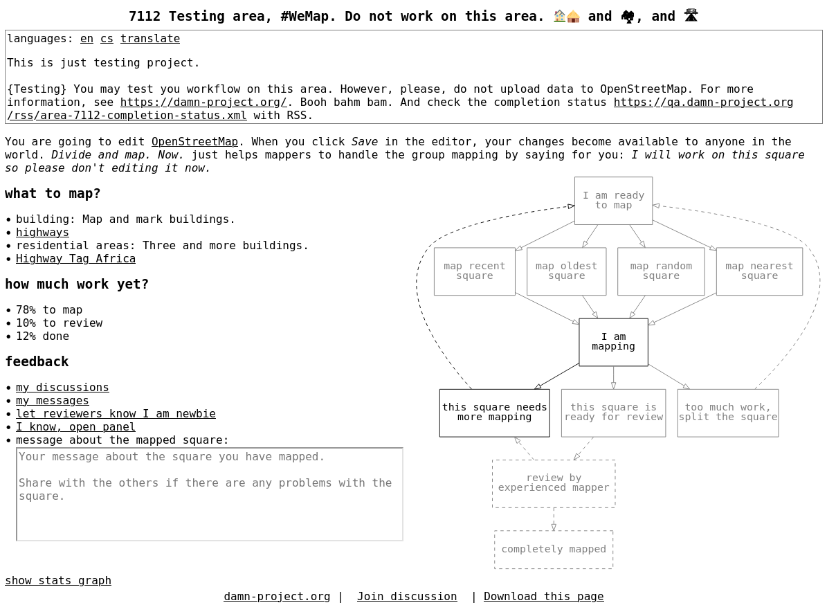
New client for beginner mappers is out, see mapper. I was thinking of how to better describe map-review-done workflow. The original client has “Show mapping square workflow diagram” showing ASCII art square’s state flow when clicked. I had and idea to show SVG figure (generated by dot) instead of ASCII art, because it is easier to generate, maintain, and translate. SVG is text, too, so I can bare that. But wait! SVG is HTML element, isn’t it? So it’s clickable, isn’t it? So it can be done interactive, can’t be?

Mapper web client of the damn-project.org

See full entry