 OpenStreetMap

intro testing
Users' Diaries
Recent diary entries

Open source culture is increasing day by day in Turkey. In this way, many platforms and associations have been established in the field of open source and data. Many of them organize events, workshops and studies in their field. Websites or social media accounts have been added to reach them. If there is an association, organization or platform you would like to be added to, please get in touch. (It is constantly updated.)

Yer Çizenler Mapping for Everyone
Openstreetmap Türkiye Telegram Channel

Introduction
My name is Japhet Masunzu from the Democratic Republic of Congo
What i like
-
Christian music
-
mapping
-
Eating rice and beans
Lien osm.org/user/JaphetMasunzu/diary
HOT Data Quality Internship 2022
HOT Data Quality Internship 2022 is a good HOT program for which we had the privilege to be selected, in order to increase our knowledge about openstreetmap data validation and quality control tools. It is really a good time of training and information very profitable.
Introduction
My name is Japhet Masunzu from the Democratic Republic of Congo
What i like
-
Christian music
-
mapping
-
Eating rice and beans
Lien
Bonjour à toutes et à tous. S’il vous plait est ce que quelqu’un peut m’aider à travers des explications comment faire pour créer un réseau OSM (groupe de 10 restreint dans lequel des personnes peuvent échanger). comment appartenir au réseau OSM de son pays?
Posted by WARUMICHRADFAHRE on 16 November 2022 in German (Deutsch).

Hab ein paar Änderungen in OSM vorgenommen, obwohl ich echt wenig Zeit dafür habe.
Meine Änderungshistorie seht Ihr hier:
osm.org/user/warumichRadfahre/history#map=12/50.9064/6.8218
Und das ist an Tracks dazu gekommen:
I want to do a study of parking lot areas vs. property taxes lost and nearby population density. So I have been working through the Houston Heights adding parking lot polygons. I may try to finish up the building outlines south of 11th street while I’m at it.

I have collected data for google
no wait I didn’t

Yep, it was a mistake :(

10000

Mein Sohn Linus ist inzwischen sieben und ich schaue mal wieder hier rein…
Ich bin inzwischen ständig mit OSM unterwegs. OSMAnd hat alle früheren Navis abgelöst, auch für die Fahrt in den Urlaub.
Okay, keine Verkehrsinfos und Langzeitbaustellen stehen auch oft nicht in der Karte. Aber seit ich die Funktion zum temporären Sperren einer Straße in OSMAnd gefunden habe, macht mir das auch keine Kopfschmerzen mehr.
Nun muss ihc nicht mehr “gegen” OSMAnd fahren, wenn ich einer Baustelle ausweiche.
Streetcomplete ist ebenfalls sehr oft an. Ich liefere im Moment Tageszeitungen in Beckum aus, und wo es die Zeit zulässt, aktualisiere ich auf dem Weg Kartendaten. Straßenoberflächen, Geschosszahlen von Gebäuden, Hilfen für Blinde an Übergängen, etc. etc.
Es gibt noch so viel zu tun … Geil!
Het zonnepark onder het locatie baken is zonnepark ‘De Watering’ Dus niet het zonnepark wat daaronder ligt.
Met vriendelijke groet, Cees Westerduin. +31 (0)6 52342122

আজ সোমবার। আজ বড়ো আজব দিন। কেমন অপচয়ে দিন।
Posted by umbraosmbr on 13 November 2022 in English.

Brazilian Mapper asks for donation to continue his full-time mapping work. Brazil
website for donation: https://opencollective.com/playzinhoagro
Preciso da sua ajuda: Como você pode ajudar a apoiar meu trabalho Criada por PlayzinhoAgro a 10 setembro 2022 em Portuguese (Português) English Version
Nesses últimos 2 anos como voluntário em tempo integral desenvolvi vários projetos de mapeamento pelo Brasil, por acreditar ser meu dever contribuir por conta do deficit que o mapa tinha na minha região. Minha meta como mapeador é tentar diminuir os espaços em branco no OpenStreetMap para que mais pessoas possam usá-los e assim mais mapeadores surgirem.
Entendo que nem todo mundo tem tempo ou interesse em mapear, no máximo fica no básico e muitas vezes acaba esquecendo do OSM por não consegui usar no seu dia a dia, ainda mais em um país como o Brasil onde dificilmente um trabalhador teria tempo para ficar atualizando mapas.
Tenho me dedicado diariamente ao OSM, mas infelizmente isso tem um custo e já que não sou nenhum herdeiro, tem sido bem difícil conciliar meu trabalho como voluntário e minha vida pessoal, já passei por fases muito complicadas desde que eu decidi me dedicar em tempo integral, mas também tive muitas ajudas.
Trabalhar no OSM não é uma tarefa fácil, pois seu trabalho nunca está concluído, sempre há novas mudanças que precisam ser mapeadas, erros a serem corrigidos, é um trabalho contínuo que exige certo nível de conhecimento e experiencia adquirida com o tempo.
Um dos primeiros projetos que eu fiz foi usando o DAMN e depois o Taskmanger para poder gerenciar e mapear cidades inteiras, com esse projeto foram quase 20 cidades que foram totalmente mapeadas desde as estradas aos edifícios.
Posted by Kai Johnson on 13 November 2022 in English.
I guess I didn’t keep up with this diary. I’ve been busy since that first entry.
I’ve gone through both Cleveland National Forest and San Bernardino National Forest to fill in and tag forest roads and trails. At this point, both forests should have all of the official routes of travel with their official names and refs. There will be some differences between OSM and the FS Topo data source where conditions on the ground are different from what USFS has in their data set.
I also worked with a team of mappers to update all the Sq___ names that were changed by BGN/USGS in both OSM and Wikidata. (See https://www.doi.gov/pressreleases/interior-department-completes-removal-sq-federal-use and https://edits.nationalmap.gov/apps/gaz-domestic/public/all-official-sq-names.) That made me really happy because the unfortunately named local “Squaw Tit” that I used in my backcountry navigation course is now appropriately named “Mat Kwa’Kurr.”
I have two things going on now. I’m filling in the roads that CBP has made in the Jacumba Wilderness Area. There’s been a lot of activity out there recently and some construction work on two new border wall segments. This activity is controversial for a number of reasons, so I think it’s important to document the impact CBP has had in the area.
I’ve also started working with the BLM Ground Transportation Linear Features data set to fill in backcountry routes in SoCal.
I’m starting with the area around Superstition Mountain in Imperial County because it’s a popular area for off-road activities. The terrain there makes navigation challenging, so good maps can make a huge difference.
Unfortunately, the shifting sand dunes in the area also make mapping difficult. And the BLM data is not very good. The BLM tracks wander off into places where there are no tracks on the ground. And the BLM tracks take some improbably dangerous routes over surface features, like crossing the sharp crest of a soft sand dune.
Posted by umbraosmbr on 13 November 2022 in English.
Projeto pensando pelo mapeador PlayzinhoAgro - Brasil
osm.org/user/PlayzinhoAgro/diary/397900 e Apoiado Pela UMBRAOSM - União dos Mapeadores Brasileiros do Openstreetmap.
Project thinking for mapeador PlayzinhoAgro - Brazil.
osm.org/user/PlayzinhoAgro/diary/397900 and Supported by UMBRAOSM - Union of Brazilian Mappers of Openstreetmap.
Reimaginando o perfil de usuário do OSM
Reimagining the OSM User Profile
I would like to start by explaining that this is an exercise in imagination on how we could improve the UX/UI in the OSM profile, this means that some changes were based on my experience and there are still some things missing that I have not explored, like the Diaries, settings and Messages, I would love to get feedbacks from you!!!

커뮤니티도 새로 둥지를 틀었고 그 안에 ‘한국/조선’ 카테고리도 만든 김에 ‘한국/조선’ 카테고리의 로고를 만들어 보려 했습니다.
원래는 삼태극 무늬를 이용한 Korea 로고가 있었으나 삼태극이 어느 한쪽에 좀 치우친 느낌을 주는 듯하여 제안을 했으나……
어찌어찌 우여곡절 끝에 ……

-
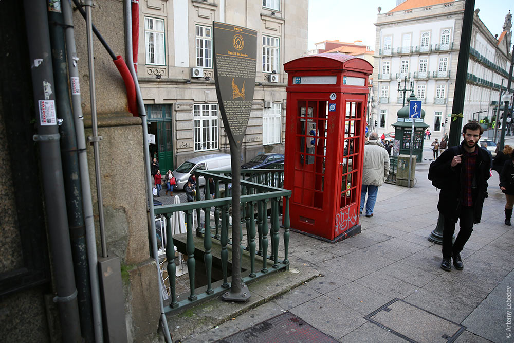
In 1992 Philippe Starck designed [oar-shaped plaques] for Paris(https://fr.wikipedia.org/wiki/Panneau_Histoire_de_Paris). They highlight historical buildings and looked very nice!
-
In 20o1 Porto was crowned European Capital of Culture, congrats! It involved a lot of development, like a reconstruction of Jardim da Cordoaria. But also installation of the Stark Plaques.
-
Location and a full list of this plaques is a mystery and is not on the internet! Ironically, the land of explorers is an unexplored unmapped land.
-
Current list is tracked on OSM wiki.
-
Fun fact, renowned/infamous explorer Artemy Lebedev took a picture of a plaque that no longer exists.
-
I need your help with finding precise location with photographing these plaques:
-
osm.org/?mlat=41.145111&mlon=-8.611339&zoom=15#map=19/41.14510/-8.61130
-
Please dm me if you have any updates about these Porto Plaques.
-
Thank you!

I am terrible at keeping journals, and this will probably be no exception, but I have been enjoying some folks’ regular updates about what they have been up to in the OpenStreetMap world. So let’s give this a try! Two weeks late already for October; life got in the way..
Mapping
I’ve had a pretty active mapping month, but also all over the place, more so than usual.
- I participated in a virtual mapping party at work. We worked on a HOT Tasking Manager project. This is the first time in a while that I had really worked with Tasking Manager. It’s generally easy to use but sometimes the instructions can be clearer. It was good to get out of my mapping ‘comfort zone’.
- I did my usual surveying while out and about using GoMap!! while the weather is still nice.
- I read somewhere that Geofabrik’s OSM Inspector had gotten an update with some new categories, so I gave that a new try. I ended up spending quite a bit of time untangling some invalid polygons.
- Used RapiD to add some government-provided GIS data. I also wrote about this, see below.
Meeting
- We had our monthly OpenStreetMap Utah meetup and it was a special and fun one! I decided I wanted to try out Every Door, the mobile POI and micromapping app. We went to a local mall and I wrote about it. We will do this again!

How to replicate a OSM database: https://jakobmiksch.eu/post/osm2pgsql-replication-script/
How to convert polygons to points: https://jakobmiksch.eu/post/osm2pgsql-point-polygon/