단순히 아파트 동호수를 101, 102, 103 등의 숫자로만 표시 하는 것은 문제가 있다고 봅니다. 검색창에 102만 처도 해외의 우편 번호가 먼저 나옵니다. 101은 부산의 역으로 나옵니다. 실생활에서도 A아파트 102동이라고 하지 숫자로 부르지는 않습니다. 검색엔진을 고려해서 숫자만 붙이지 말고 101동, 102동, 103동, 201동처럼 동을 붙여서 적어야 찾기 편해집니다. 101 102 201등 숫자는 어느 아파트의 동을 검색하려면 찾기가 어렵습니다. 네이버 지도나 카카오맵에서도 멀리서는 숫자로만 표기하지만 동은 가까이 축적해야 붙습니다.
Users' Diaries
Recent diary entries
Marquette,mi 1. Marqutte, mi 2. Blythe, ca
Hallo,
ich gebe Nachhilfe bei mir daheim und möchte das in OSM eintragen. Hat nicht so richtig geklappt. Kann mir jemand helfen, was ich da tun muss? (In kleinen Schritten, bin neu bei OSM)
Vielen Dank
Erich Lerch
Having fun doing project preparation with kind of some enthusiastic people around here before the actual field trip. Hope something big will come out lately. Best of luck guys.
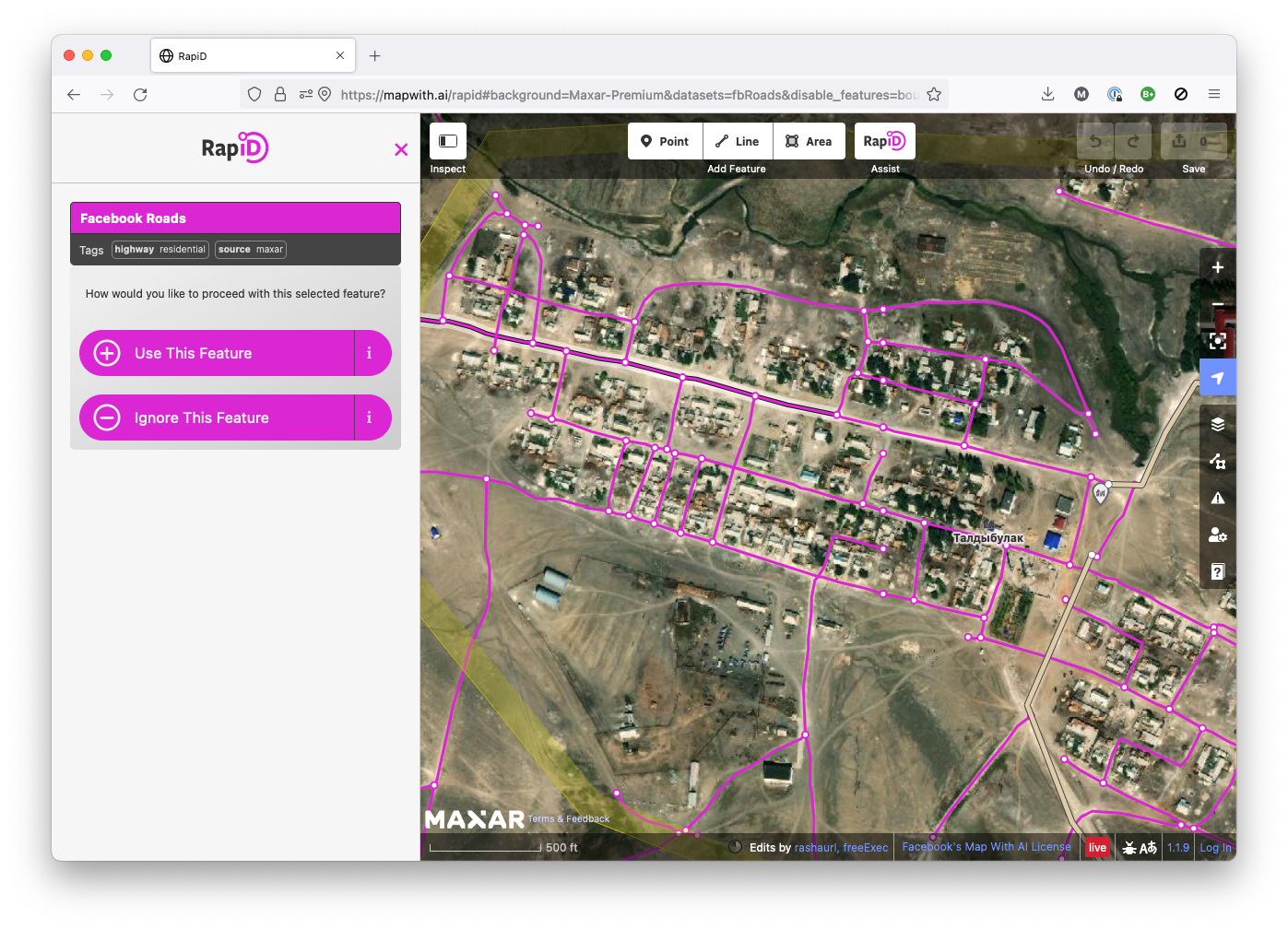
RapiD is an alternative to the OpenStreetMap iD editor that adds the ability to easily add data from approved external sources to OSM. Chances are that you—like me—know RapiD from the MapWithAI initiative, Facebook / Meta’s effort to publish road geometry derived from aerial imagery using machine learning. RapiD started out to support this effort; a fork of the iD OSM editor, RapiD added a layer to display the ML-detected road segments, and a nice user interface to add these segments to OSM, connecting them with the existing road network where possible.

Оох ну и много же дел в моём Барнауле… Столько всего есть уже на картах, но много чего нет… Ну, я начинаю потихоньку дополнять карты хотя-бы в своем районе.
Караоке клуб на Павелецокй
จ.เจริญยนต์ (ปากห้วยวังนอง)
In Deutschland sind ca. 2.400 Fahrradstraßen in OpenStreetMap erfasst.
Mehr als die Hälfte der erfassten Straßen leider ohne entsprechende Verkehrszeichen.
Da die reine Quantität von Fahrradstraßen nichts über die Qualität aussagt, habe ich im Rahmen der OSM-Verkehrswende-Berlin Gruppe angefangen den aktuellen OSM-Erfassungsstatus etwas genauer zu analysieren.
Viele der erfassten Fahrradstraßen sind nur rudimentär getaggt, wichtige Zusatzzeichen (KFZ frei, Anlieger frei etc.), die Rückschlüsse auf die Qualität (Stichwort „echte“ und „unechte“ Fahrradstraße) zu lassen, fehlen leider häufig.
Neben dieser Mindestanforderung sollte auch die Zugehörigkeit zu einem vorhandenen Radnetz (LCN, RCN) sowie die Breite und auch eine eventuelle Relation zu einer Fahrradzone mit erfasst werden.
Ich werde diese Diary-Eintrag die nächsten Tage um alle relevanten Tagging-Informationen erweitern und auch Links zu eine einfachen Projekt Seite erfassen.
Eine statische Liste aller Fahrradstraßen mit mindestens einem zugewiesenen traffic_sign findet ihr hier: https://wiki.radmonitor.de/

Fersenlutzel und Pudelmutter am Südostrand der Alpen ist eine sehr spannende Sagenlandschaft, unbedingt Wert georeferenziert zu werden, aber in JOSM muss ich es nicht haben. In JOSM landen primär die georeferenzierten Papierkarten mit Rad- oder Wanderwegen, die ich zur Qualitätssicherung meiner Daten verwende.
Nativ unterstützt JOSM keine georeferenzierten Einzelbilder, dazu sind Plugins erforderlich.
Mit JOSM georeferenzieren
Für kleine Bereiche geht das recht gut mit dem Plugin PicLayer [1]. Die optische Vergleichsmethode eignet sich gut für Kartenausschnitte mit wenigen km². Für größere Bereiche wird es zunehmend schwierig. Da ist es besser externe Programme zu verwenden. Welche spielt keine so große Rolle, das Prinzip ist überall ähnlich.
Eine Ausnahme ist das QMapTool Gitterwerkzeug in QMS [2], das ein viel schnelleres Referenzieren von Karten mit Koordinatengittern erlaubt.
I have been an active OSM mapper (and contributor to some HOT task mapping projects in different countries ) since 2013, mainly mapping based on satellite imagery. My main focus has been on Ethiopia, North Korea and DR Kongo.
At the moment (from March 2025 on) I try to map waterways and watersheds of the Ethiopian tributaries of the Blue Nile (called አባይ = ābayi/Abbay/Abbai in Amharic). A lot of theses waterways and the areas around them have been very poorly mapped yet. I have started with the river which is called Rahad (نهر الرهد) in Arabic and Shinfa (ሽንፋ ወንዝ) in Amharic.
The rivers in the Ethiopian highlands are of crucial importance for the cultivation of the land and the settlement structure - in a way which is unusual and often uknown for European people: The settlements are usually on top of the mountains (using the rain at the main water source) between the rivers, not at the rivers. A lot of the rivers and their ravines are blocking travelling and transport, not supporting it.
River Shinfa (ሽንፋ ወንዝ / نهر الرهد)
Relation of the main course of the river
Detailed Mapping Finished based on Esri Imagery
Downstream
River Shinfa - right tributary A
* about 10m wide at confluence, clear/dark water, meandering (SI = 1.84)
* so far mapped length 7.60 Km - E to W
* from 12°03’21.0’‘N 36°37’51.5’’ E to 12°03’54.6’‘N 36°35’39.0’’ E
* height: 1225 m to 1080 m (19.08 ‰ botton slope)
River Shinfa Section 1
* up to 30 m wide, ravines, light brown water, twisting (SI= 1.436)
* length 7.18 Km - SE to NW
* from 12°03’54.6’‘N 36°35’39.0’’ E to 12°05’33.5’‘N 36°33’28.1’’ E
* height: 1080m to 1000 m (11.14 ‰ botton slope)
River Shinfa - right tributary B
* 35m wide and more at confluence, light brown water, twisting (SI = 1.504)
* so far mapped length 21.39 Km - NE to SW
* from 12°08’39.8’‘N 36°40’37.9’’ E to 12°05’33.5’‘N 36°33’28.1’’ E
* height: 1200 m to 1000 m (9.35 ‰ botton slope)
Уважаемые картографы. Такая просьба. Есть два дополнительных сервиса. Один с полной статистикой по своему аккаунту на OSM, кажется, называется ninja. А второй имеет карту с фасеточной разбивкой по упоминанию аккаунтов. Буду очень признателен, если кто подскажет полные адреса этих сервисов. Заранее признателен.
Vincent Privat posted on twitter of a gun shop across the road from a bank. WeeklyOSM reported it in №634. So it got me thinking. 🤔 And hacking. 🙂👩🏻💻
I built a new tool osm-distance-to-nearest which calculates “how close the nearest X is for every Y?”. When you download the OSM Planet File (~70GiB!), and run this command, you’ll get a CSV file for every shop=weapons in OSM, with how far away the nearest bank or ATM is.
osm-distance-to-nearest -i ~/osm/data/planet.osm.pbf -b amenity=atm,bank -a shop=weapons -o p_guns_bank_
Vincent’s case is a weapons shop Armurerie du Vieux Bourg de Kourou (node 2,992,825,744) which is 60m from an ATM operated by La Banque Postale (node 3,022,885,288). at 5° 9′ 55.134″ N 52° 38′ 28.9788″ W in Kourou.
But there are more than 300 weapon shops within 60 metres of a bank or ATM! There are many weapon sells next door to a bank. This is so practical! 🤣🤣 Full formatted table is in this comments.
Had to correct the school premises because it place houses people lived in as school buildings and marked one of the 2 school buildings as a house. overall the school premises on the map have been halved as it also contained a farmers field
Hi everyone, I started my own Web development company in London, I would like to add it on the map on openstreetmaps, how to add it?
พญาไฟ
Arthur Brown
Joseph Bazalgette is rightfully lauded as an accomplished Engineer & heroic in many actions, including in his role as chief engineer of London’s Metropolitan Board of Works, implementing gargantuan sewage works that will have saved millions of Londoner’s lives from the threats of cholera & other water-borne diseases. Few people will realise that there are many similar Victorian-era heroes within Nottingham’s history, and it is likely that even fewer people could name any of them.
Go to this diary entry for more info on any year quoted here.
Today’s diary will commemorate Nottingham’s Borough Surveyor and Engineer Arthur Brown, and underline his achievement in designing & building the 1884 Beck Valley Storm Water Culvert.
ح ب س
Le changement climatique affecte la morphologie des arbres et leur résistance à la sécheresse. En effet, en cette année particulière, les végétaux ont subi un stress plus important que les années précédentes et que cela se retrouve au niveau de leur croissance.