OpenStreetMap

Annadruman Ring Fort, Castleblayney, Monaghan, Rep of Ireland
Users' Diaries
Recent diary entries

Introduction
Hi, this is my first osm blog post :-)
Recently I stumbled upon some large areas that where mapped as forest, but Bing aerial imagery showed just a bleak, empty space. I was irritated first, shocked right after - having some thoughts about the earth climate in mind. Only some time later recognized: “Ok, wait. What do you think where your furniture comes from? This kind of thing has to happen. These are actually reneable resources.”

Album, comparing Bing, Esri and Esri Clarity imagery
Checking sources

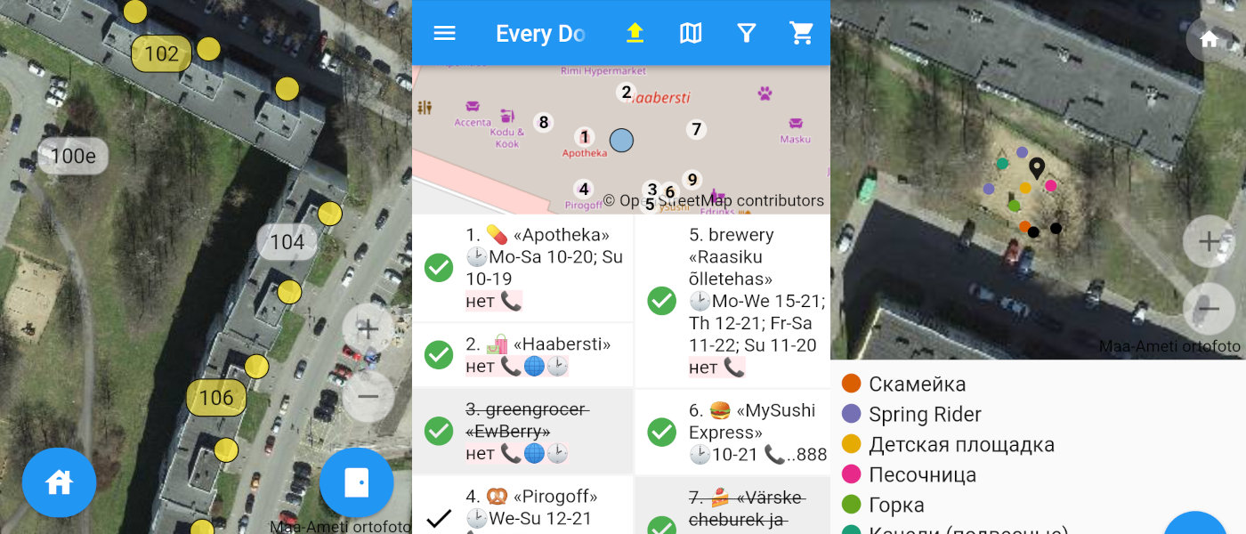
Today I’m proud to present my new OpenStreetMap editor. It’s called Every Door and works on both iPhones and Androids. I shared the idea last Summer at a State of the Map, but started writing just late October. In the last month and a half thirty people made ten thousand edits with the editor and helped make it much better. Now I’m launching the open testing.
The official website has links to TestFlight and Google Play, a short video, and a FAQ.
I’ve got just one feeling: at long last. One way or another I was suggesting something like that for OSM since 2013. Made a failed attempt with OpenSurveyor. Watched with hope for big company projects with paid developers — but all these have disappeared. In this time we’ve got one amazing StreetComplete, which I like a lot, although it’s not for me.

I am following ᚛ᚐᚋᚐᚅᚇᚐ᚜ as they are leading the way with a diary entry. This will be a work in progress entry until the end of May.
Posted by ilyaiodo on 11 May 2022 in Russian (Русский).
Вчера проехался на запад от дома. Заехал на пруд Кунцевщина, заехал на островок. Хорошее место для шашлыка, правда людное. Заехал на заправку взял выпить и решил проехать по путепроводу через МКАД на водоотстойник (Очистное сооружение дождевой канализации районов Красный бор и Сухарево). До путепровода было далеко. Проехал под мостом, пересек поле и выехал к пруду №3 Дививелко. Объехав вокруг водоотстойника решил отдохнуть на пригорке, понаблюдать за закатом.
Archives plug-in for GDS
Now that the weather is more welcoming, i.e. dry, I’ve gone back to mapping walking and hiking trails in my area. I had done that before, either added the trail completely new as a relation with all that’s included, sometimes just added the trail markers, where the trail was already mapped. Most times, I try to do mapillary as well, sometimes just with the phone, sometimes with a 360° camera.
Today, I went to map the O’Gorman’s Lane Loop which is only a 4km walk (that is if you don’t get lost…), but it meets another, longer trail which was already mapped. But anyway, I ran into an American couple, Don and Kim who are exploring Ireland on rented motorbikes, but are also avid hikers and have hiked across the Czech Republic, Germany, Switzerland etc. Don was telling me that he has this app maps.me which shows all the trails and it’s free! And I said, well, it’s people like me who add those trails to OpenStreetMap which in turn adds it to your app. We parted ways, but I had a suspicion that I would run into them again after in the only café in the village. And I did. I walked up to them and gave him an openstreetmap.ie sticker (always handy in any bag I carry around). Once I had taken off my backpack, he could see the “OpenStreetMap surveyor” on my high viz vest, and the penny dropped. He had loads of questions and all the right ones, so I joined their table and chatted away with him.
He said that he wanted to map all the benches along the Camino. :D (We had noticed earlier that there are never enough benches along hiking trails in Ireland.) He also wants his name on one of those benches, and I explained that those little plaques can be added to OSM as well. He was very impressed, I think. They wanted to pay for my scone, but I had already paid. But we decided to share a taxi back, even though I would have been fine on the bus, and had told them about the bus as well.

I started before COVID19. We had some success, but then COVID19 hit us and everything stopped. We are at it again.
Posted by Lawi_Gn on 10 May 2022 in French (Français).
Last updated on 10 October 2022.

Que fait habituellement Moussa DIALLO avec OpenStreetMap?
Moussa Diallo aime les cartes et Internet. Il estime que les données géographiques sont une plate-forme essentielle en tant que telle, devraient être gratuites, il fait donc sa part. Moussa Diallo cartographie principalement la Guinée, le Mali et le reste du monde. Vous pouvez consulter sa page utilisateur OpenStreetMap , ses traces GPS et bien sûr ses modifications OpenStreetMap sur lesquelles il y a un résumé statistique pratique et une belle carte.
Quelles régions du monde cartographie-t-il?
Moussa Diallo vit à Nzérékoré. Il cartographie son environnement, les lieux qu’il connaît bien et tout ce qui se trouve sur son chemin et de ses courses quotidiennes. Moussa Diallo cartographie parfois aussi d’autres régions où il voyage, notamment les sous régions qu’il connaît le mieux. Il adore l’Afrique et la Guinée en particulier pour les occasions d’améliorer les cartes des lieux qu’il affectionne, notamment Conakry, Kankan et Nzérékoré.
Quels outils utilise-t-il?
Moussa Diallo recueille des traces GPS à l’aide d’un OsmAnd. Les outils de post-production incluent Go Map et StreetComplete.
Moussa Diallo joue avec des application de production des données sur Android mais fait presque tout son Mapping en utilisant JOSM. Anciens projets Moussa Diallo a commencé à travailler OpenStreetMap depuis avril 2017.
Je veux en savoir plus sur Moussa Diallo
Moussa Diallo se cache sur Twitter, LinkedIn, Facebook. Vous trouverez également la page de l’ONG FreeLocalMappers.
Posted by geomir on 10 May 2022 in Brazilian Portuguese (Português do Brasil).

Iniciamos no setor de Geoprocessamento da Prefeitura Municipal de Jaraguá do Sul a 12 meses atrás a migração e sobreposição no OSM das edificações através do JOSM - Editor Java do Openstreetmap de 72.678 edificações que recebemos a partir da restituição aerofotogramétrica contratada pelo município de Jaraguá do Sul em março de 2020. Iniciamos esse trabalho de atualização na área central da cidade e avançamos para atingir todos os 38 bairros e as 15 localidades rurais que compõe o Município. Para esse trabalho contamos também com a participação de vários Bolsistas e estagiários de Engenharia Civil e Arquitetura que desenvolveram também essa atividade durante o tempo que estiveram no setor de Geoprocessamento. Outro editor que também foi usado com bastante frequência foi o Editor iD - Editor no navegador web do OSM utilizado para demais atualizações como número de edificações e seus vários tipos de usos, etc. Queria deixar registrado que as ferramentas mais usadas no JOS após a importação das edificações em blocos foi o plug coloured streets para colorir as edificações com números já existentes no OSM, facilitando o uso da ferramenta Substituir Geometrias, e da configuração de seleção de nós e tags. Também utilizamos no JOS a URL de configuração de serviço TMS/XYZ:https://www.jaraguadosul.sc.gov.br/geo/ortomosaico2020/{z}/{x}/{y}.png mosaico de ortofotos da mesma contratação citada acima. É Importante salientar que essa base atualizada tem grande importância para o Município de Jaraguá do Sul por fazer parte da página inicial do Geoportal do Município que pode ser visualizado no seguinte endereço https://sistemas.jaraguadosul.sc.gov.br/index.php?class=GeoMapView. Agradecemos também o apoio e as dicas do Engenheiro Helio C. Tomio do setor de parcelamento de solos na concretização desse trabalho.
The Sahrawi Arab Democratic Republic does not exist in the annals of the United Nations, please remove it from the map.
Posted by Decor Colors Ribeirão Preto on 10 May 2022 in Brazilian Portuguese (Português do Brasil).
A casa do cimento queimado em Ribeirão Preto Rua João Penteado, 576

Cartography is an artform. Besides being used for art, it is a practice rooted in subjectivity. For most people, it may be only a means of navigation, but any cartographer acknowledges that they make decisions based on their own opinions when making maps. OpenStreetMap is one of the more objective maps out there, but it’s still not always clear how to map things. As a community, we’ve had to make numerous decisions on the “best” way to map something. Sometimes, we don’t have a singular answer. Users of OpenStreetMap data must interpret these decisions as best they can. Tagging is usually what comes to mind when considering what comes into dispute here, but scope is important as well. And this is where privacy comes in.
Privacy status quo
We have some privacy standards. Besides GDPR compliance, the Data Working Group redacts edits that introduce personal information, such as annotations intended for an individual that may link their account to a real person. It generally isn’t acceptable to map features inside private residences either, like rooms or toilets. These may come as common sense to most, but others still could have counterpoints. The level of detail most are comfortable with is what is visible from street level or the sky. I think this is a good standard, but some are still left uncomfortable. There’s the occasional new mapper who deletes driveways leading to single-family homes. It may not even be their own driveway, but some may be unfamiliar with OpenStreetMap’s tagging system that makes it clear when a driveway is private and that it is, indeed, a driveway. One cannot fault a person for wanting privacy; the concern then is about damaging data (digital vandalism). At least where OpenStreetMap is based, there is no law against making a map of someone else’s property. Legal concerns about cartography are a separate matter not related to individual privacy, which is my focus here.

Ho imparato ad aggiungere punti con l’applicazione OSMAnd, molto utile. Grazie a @Ysogo
Posted by Nonichase on 7 May 2022 in Chinese (China) (中文(中国大陆)).
Last updated on 7 October 2025.

0
Posted by fsopena on 7 May 2022 in Spanish (Español).
Ruta circular que parte de Aso de Sobremonte , para pasar por Betès antes de comenzar la subida. Subida que primero nos llevará a Punta Cerruza , luego ya vamos recorriendo las numerosas Puntas que rodean este Valle, Punta Faceras , Burrumbalo , Sarrataclau , Peñas de Aso, Balposata, Canales….y acabamos en el Monte Lucas donde iniciamos el descenso. Desde las distintas puntas y picos hay magnificas vistas al Vignemale, la sierra de Tendereña, Macizo de Argualas etc. La ruta no tiene complicación. La pongo moderada por la distancia y el desnivel. osm.org/user/fsopena/traces/4324177

fir and fine
This is a possible site: SA Property and Planning Atlas. However (I now see) there is no copyright notice displayed - so best use the other explicitly CC licenced sites offered by the SA government.
I got tired of adding addresses to hundreds of houses, so reluctantly decided to research custom presets. What a pleasure it turned out to be - I recommend it. Here is all it took:
<?xml version="1.0" encoding="UTF-8"?>

<!--
* Put this file in ~/snap/josm/common/  [This is specific to Ubuntu Linux]
* Add to JOSM by selecting  Edit / Preferences / Tagging Presets
* and then press '+' on the top-right, then specify the path to this file.
-->

<presets
  author="xrisnik"
  version="1.0"
  shortdescription="Presets File"
  description="Setting residential building and address in JOSM">

  <item name="Residence + address" type="closedway">

    <label text="Edit"/>

    <space />

    <combo key="building" text="Residence type" values="detached,terrace,semidetached_house,apartments" display_values="Detached,Terrace,Semi,Apartments" default="detached"/>

    <text key="addr:housenumber" text="Number" default="" delete_if_empty="true"/>

    <text key="addr:street" text="Street" default="" delete_if_empty="true"/>

    <space />

  </item>

</presets>


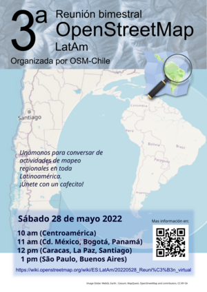
Estamos muy cerca de tener nuestra primera tercera reunión bimestral latinoamericana de mapeadores en OpenStreetMap. Será virtual y tú también puedes unirte sin importar si apenas empiezas a mapear o ya eres parte de una comunidad de ayuda de mapeo abierto.
En el wiki de OSM Chile se muestran los detalles de la reunión para este sábado 28 de mayo de 2022.