Users' Diaries

Recent diary entries

Hi all,

I hope you are all well and safe.

As many of you know, we have been working on a new model to ensure Tasking Manager (TM) continues to get the love and attention it well deserves. As we unpacked the value of the project, we started to realise just how much we value the inputs and contributions of a large collective of contributors lodging issues, PRs, code, resources etc. I went through every single issue on TM’s Repo and was really blown away by just how much support the project gets both in front of and behind the screens.

Moving forward, we really want to return TM to its former community-lead glory and as such have put together this proposal for what TM’s Tomorrow could look like.

https://docs.google.com/document/d/1tTT4oKUN34FThzbNFZKfj0lhQOMRB4uTF1n2rO1iHrc/edit?usp=sharing

I invite everyone to comment in the doc on things they like or don’t like or questions they have so we can reenergise our love for the TM and it’s sustainability and evolution. There is a long list of Frequently Asked Questions (FAQ’s) at the end of the doc, but I also invite you to add your questions as a comment to the FAQs so we can endeavour to answer them as well.

I really look forward to your feedback.

Kindness,

bo

p.s. we are also now on the hunt for a possible community representative product owner for TM, so if this sounds like something you could be interested in, please get in touch.

Location: Naz, Esserts-Salève, Monnetier-Mornex, Saint-Julien-en-Genevois, Upper Savoy, Auvergne-Rhône-Alpes, Metropolitan France, 74560, France
Posted by dcapillae on 6 October 2021 in Spanish (Español). Last updated on 4 July 2024.

Bibliobús municipal de Málaga Bibliobús municipal de Málaga junto al colegio María Zambrano. Fuente: trabajo propio (CC BY-SA 4.0) disponible en Wikimedia Commons.

Hace algún tiempo me propuse mejorar la información geográfica disponible en OpenStreetMap relativa a bibliotecas y librerías. Otras ocupaciones me han distraído de este empeño, aunque continúo trabajando en ello. Recientemente se han incorporado al mapa los datos abiertos del Ayuntamiento de Málaga relativos al equipamiento municipal de bibliotecas.

See full entry

Location: Centro Histórico, Centro, Málaga, Málaga-Costa del Sol, Málaga, Andalucía, España
Posted by SebastianHelm on 6 October 2021 in English.

Now it is one week since I started working with OSM. Sadly, my initial enthusiasm has waned. While there were many nice experiences, above all encountering some helpful fellow mappers, a feeling of meaningful connection with the purpose of the project did not develop.

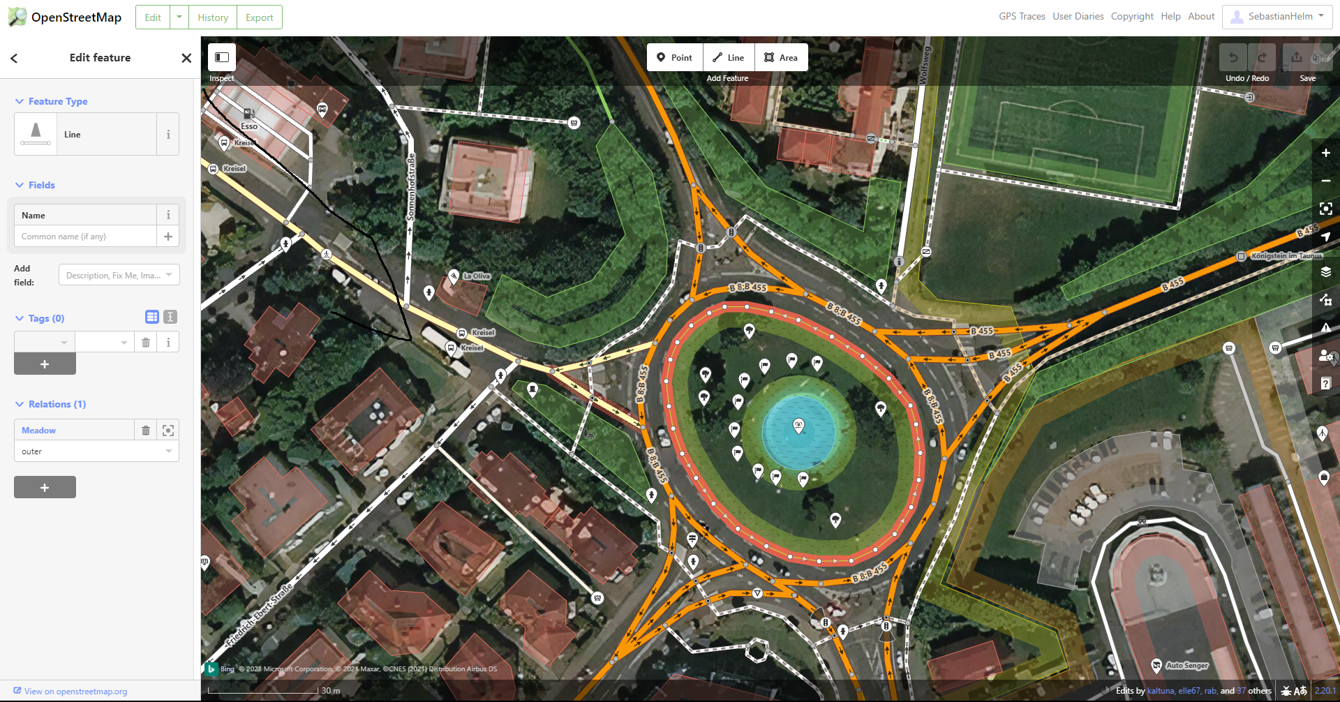
The apps I used show little consideration for what’s meaningful to the average mapper or end user. The below example from iD may serve as an illustration for how haphazardly it has been decided what gets displayed and what gets hidden. This matters because the UI displays no settings button to override that decision. iD visibility example

See full entry

Hi everyone,

A new version of MapComplete has been deployed. It has a lot of exciting new themes and features, which I’d like to highlight in this diary entry.

New themes

The Flemish touristical agency (Toerisme Vlaanderen) has asked me to create a tool to help them to map charging stations, restaurants, café’s, …

This has resulted in quite some fun new themes:

At last, the theme I’ve quickly made as demo with hackerspaces and makerspaces is online as well.

Other improvements

At the same time, I’ve been doing lots of work on improving performance. A lot has changed under the hood, resulting in a way more robust and fast experience. On high zoom levels, the OSM-API is used directly, bypassing overpass all together. If overpass-api.de is down, failover to other instances is now builtin. At last, caching is a bit more aggressive and if the data on your machine is recent, no new data is loaded at all.

Earlier releases had some important features to, which I’d like to highlight as they can be important for theme builders:

  • A layer can configure filters
  • A layer can demand to have ‘precise input’, showing an extra draggable map (with e.g. aerial photography) when a new point is added to the map.
  • A new point can be snapped to an already existing road, e.g. when adding a bollard
  • A layer can define that a point can be (soft) deleted
  • The new Mapillary-API has been integrated
  • Some themes have a download-button enabled to download as GeoJson or as CSV

I need your help!

See full entry

Posted by LySioS on 5 October 2021 in English. Last updated on 6 October 2021.

Disclaimer #1 I’m not used to speak english anymore, I apologize if some sentences sound clunky.

Disclaimer #2 Last time I added pictures in the diary post, they would not always show up. Click on the link if it happens.

Introduction

So now, I’d like to start with a provocative joke :

Marck Zuck. comes into his office and asks his colleagues :

– Hey, do you know why there’s a magnifying glass on the OpenStreetMap logo ?

– Well, it means that OpenStreetMap helps you find places and amenities on the map.

– Not a all ! It’s because you won’t notice the credits without one.

Text Vs Logo

My point is that OpenStreetMap lacks a strong visual identity. I believe I started to notice it when I read some Facebook employee saying that a logo would be easier to credit on a map than the (c) openstreetmap contributors. 🤨

Dishonesty aside, he makes a point. The (not so) new OSM logo is gorgeous and deserve more consideration and would help OSM maps being more recognizable and popular. In times where we are constantly facing pictures, logos, visuals, a brand/company/project/whatever need a clear visual identity to exist in our digital world. The actual text only credit looks like good oldies websites.

Besides, sometimes, OSM credit is in competition with some other logo. I was thinking of Mapbox but I couldn’t find an example with an OpenStreetMap map.

See full entry

You may have heard people talk about ‘priority countries’ in relation to HOT’s work and the regional Open Mapping Hubs (the Asia Pacific hub for example).

HOT has committed to furthering its longer-term vision across 94 countries through 2025. Initial priority countries were selected based primarily on disaster risk and acute deprivations needs (measured through the multidimensional poverty index).

I just wanted to flag that if you ever need to know which countries they are or the process for updating the list, there is now a page on the OSM wiki at https://wiki.openstreetmap.org/wiki/Humanitarian_OSM_Team/Priority_countries.

Please let me know if there is any information missing that you think should be there…

Posted by HeiligerHein112 on 4 October 2021 in German (Deutsch).

Ich arbeite in einer Leitstelle und wir greifen auf die Daten von OSM zurück. Manchmal ist es schwer ersichtlich, sofort und schnell eine Adresse zu erkennen, wenn Adress-Punkte teilweise neben Gebäuden versorgt werden. (Ich weiß nicht, wie das Ganze mit den Layern funktioniert, aber die Adress-Punkte “verrutschen” häufig und sind dann neben den Gebäuden.) Laßt doch bitte die Hausnummern in den Gebäuden und setzt nur Adress-Punkte auf Grundstücke, auf denen (noch) kein Gebäude steht. Danke.

Posted by drolbr on 4 October 2021 in English.

While the heart of OpenStreetMap is the community of mappers, it has also a remarkable ecosystem of software developed and used for OpenStreetMap. Many people are surprised to learn that it is so federated that the OpenStreetMap Foundation does only a tiny part of it.

The key to understand that is that many software projects have developers out of personal passion. The long time editing tool Potlatch has been developed and kept alive by Richard Fairhurst, JOSM luckily has a whole team behind it, and also Vespucci, OSMAnd, Nominatim and Osmium each are closely tied to names, as well as many other tools. This both keeps each of the tools focused and gives them a direction. Large organizations cannot offer that, because more often than not the managerial fashion of the season will interfere with pursuing long term goals.

Nonetheless, outsiders that expect a single point of contact shall have one. This is where the idea of the Engineering Working Group comes into play: it has a more specific mission than the board in general, but it still can send people and inquiries to the right places.

The EWG does not replace issue trackers. The EWG is not the right venue for comprehensive visions of the future. But it shall help to improve the flow of information related to development of OpenStreetMap related software.

I’m happy to chair the just restarted EWG.

See full entry

Location: Gemarkung Elberfeld, Elberfeld-West, Wuppertal, North Rhine-Westphalia, Germany
Posted by bryceco on 3 October 2021 in English.

Go Map!! v3.0 was released today for iOS, and while superficially not much looks different, there are some big changes under the hood: All 38,000 lines of code are now written in Swift after a laborious conversion from it’s original Objective-C implementation. This make the code faster, easier to understand, easier to debug, and brings it in line with Apple’s direction for modern apps. It also greatly simplified a lot of refactoring to improve general readability of the code base. If you’re a developer this is a great time to get involved with the code.

Background

My involvement with OSM started in March 2012 and I wanted to be out surveying and mapping on my iPhone. I had downloaded the few iOS apps that existed at the time (remember iLOE and Pushpin?) and found them too limited. Although I had a strong Windows/C++ programming background I was new to iOS, Objective-C, OSM, and GIS. Nevertheless I began work on the first version of Go Map!! writing in Objective-C and learning about the OSM API along the way. (Apple did not introduce the Swift programming language until several years later, and it took an additional several years to become stable.)

I wasn’t really sure whether a new mobile editor was something of interest to the OSM community, but in October 2012 I drove down to Portland, OR for my first SOTM US, where RichardF (author of Potlatch, the OSM web editor at the time) delivered a talk titled (IIRC) “Let a thousand editors bloom” where he suggested that OSM should have a wide variety of editing tools, and the more the better. I’d been working on the app for only a couple months and his talk inspired me to continue.

See full entry

Posted by paradigmet on 3 October 2021 in Swedish (Svenska). Last updated on 27 November 2022.

Nu när jag blivit varmare i kläderna efter några år av att ha kartlagt lite här och var där jag tidigare har bott i Höganäs, Skäret och Helsingborg. Städer jag känner som Malmö och Lund eller har vandrat i fjällen.

Nu har jag flyttat till Ängelholm och jobbar regelbundet i Ödåkra. Vilken skillnad det blir när man kan kartlägga säkrare och våga göra ändringar. Nytt är också att jag har skaffat körkort så jag börjar se över vägar utöver tidigare nästan uteslutande gående och cyklist perspektiv.

Jag känner dock ett problem nu när jag kom till Ängelholm. Denna staden är kartlagd för mycket länge sedan och staden har växt och förnyats. Den skiljer sig kraftigt från alla andra skånska städer som jag har kartlagt i och jag känner att jag behöver hjälp för detta är ett stort projekt.

Jag behöver hjälp med att förnya Ängelholm eller att arbeta om det så att det liknar dels verkligheten och dels liknar hur andra städer är kartlagda så att den hänger med.

Det tog sådan tid känner jag att komma igång trotts att det finns mycket information så finns det väldigt lite praktiska genomgångar som jag känner till för att börja kartlägga. Om jag skulle träffa någon som är intresserad av att hjälpa till så känner jag att det kan ta lång tid för personen att komma igång då det saknas en lätt väg in. Det är en rätt hög tröskel trotts att web-gränssnittet är enkelt. Det ligger mycket i rädslan av att göra fel och att om ett litet tag så kommer alla att ha en bättre eller sämre karta till följd av ens ritningar.

Was doing some mapping, and noticed the shoreline in OSM didn’t line up with the latest aerial photos… By like 50 meters.

Doing some spot checking around the great lakes, the other lakes seemed fine, except in a spot in Lake Huron, the water was about 25 meters more in shore.

I guess according to NOAA’s data, in 2020 Huron-Michigan had really high levels, and 2021 is going down (2 feet) almost halfway to the mean. So… maybe in 6 years, the water level will be back down, so no changes need to be made to the map.

Location: Macatawa Park, Macatawa, Park Township, Ottawa County, Michigan, 49434, United States

(FR: L’anglais a été utilisé pour atteindre une plus grande auditoire parmi les contributeurs OSM)

This journal entry serve as my comments for the changes I made on the Réservoir Beaudet. (Changeset: 112010724)

There are currently major ongoing constuctions at the area marked as landuse: consctuction- that is principally the verification I needed on my changeset; If somebody more experienced can double check I dont break things, that would be great.

The end result is half of the area will be converted to a park and the rest will be converted into a water area. Source: Embedded Youtube video on the project announcement web page: https://www.victoriaville.ca/nouvelle/202104/4090/lancement-des-travaux-de-restauration-du-reservoir-beaudet.aspx (all in french)

Changes made are up to date as of October 2021 with a local survey as a source, with surrounding cycleways being completely closed to the circulation. I added the temporary cycleway which is part of the “railway:abandoned” way east of Route de la Grande Ligne.

Thanks OSM!

Location: Victoriaville, Arthabaska, Centre-du-Québec, Quebec, Canada
Posted by Marcos Dione on 30 September 2021 in English.

Have you ever tried to share a location with a OSM based application with another person? I have tried many times. My issue is that I’m almost the only person not using gmaps, and so far I haven’t been able to do that successfully. At the beginning I thought it was a Google thing, where they forced their product down everybody’s throats by ignoring geo: URIs, but last night I found the reason:

Messaging applications do not recognize these URIs.

To be honest, Google does somehow force themselves on everybody’s throats: It doesn’t send geo: URIs, just a link to goo.gl. Many other Android map apps do the same, not always to goo.gl but other times to their own sites. So far I have only found OsmAnd that sends geo: links. But all of them can handle such URIs, they’re not stupid :)

Between sender and receiver there’s the messaging app, which acts a the transport. So far I have found only Element Android (Matrix’s client) that recognizes geo: URIs as links and lets Android resolve that into a map app. Other IM apps treat them as just text. Most browsers will handle geo: URIs if they’re a link in an HTML page, even on the desktop version, but most will not handle it if you type it in the location/search bar.

I know this does not seem completely related to OSM, but I think that being able to share locations from any map app (most of them OSM based), using any messaging app and viewing the location with any map app (again, most OSM based) is a good thing to have.

I started a small wiki page tracking app status and sometimes links to the issues in their bug trackers we we could go and put some pressure for support. osm.wiki/Geo_URI_scheme Go and vote in your favorite apps, or open new ones!

Posted by Oleg Kholin on 30 September 2021 in Russian (Русский).

Всем доброго времени суток! Такой вопрос, комрады. Давно не заходил на карты от Бинга. Вчера карта попалась в поиске Карта от Бинга Судя по содержимому, это копия карты OSM. И когда Микрософт начал использовать их для своих нужд?

Posted by Nicxon Piaso on 30 September 2021 in English.

As of this week, I tried using the indoor mapping tool esp. room tags with RELATION to a particular building. I am seeing that this mapping method is now appearing in #https://openlevelup.net/?l=0#23/-6.14031/143.65817! application( OSM indoor Mapping app).

Good to see OSM being taken a step up for us a OSM Mappers in wherever we are mapping. With Indoor mapping it’s more convenient the Mapper should know what exists indoor in a Building( eg. the doors, partition walls etc). Once you are content with it you can create indoor plans. I have used a LEICA Disto in doing Room plans and the indoor mapping function complements the method of capturing details inside a Building.

Thanks to the Developers/Programmers behind this tool. I really appreciate this function and the work you are doing.

Happy Mapping!

Posted by SebastianHelm on 29 September 2021 in English.

Started editing today. Very impressive website! Coming from Wikipedia, much of it is straightforward, but the fact that discussions are attached to individual edits, not to features, takes a bit of a leap.

The tutorial was very good, only gripe is that for tracing the shape of a building they selected one that has a protrusion on the south side, but when one follows the instruction to meticulously enter the shape, it says something like “It looks like you’re having problems tracing the shape” and forces one to completely and scrupulously redo the task – until one figures out that one actually gets punished for being too meticulous! 💢

Also worked with StreetComplete, which is very convenient for the cell phone. My main wishes:

  1. Terms such as “surface=sett” should link to the wiki so that one can read the complete explanation, instead of having to guess from one tiny picture.

  2. When I mistakenly tagged the wrong building, there was no easy way to undo the mistake. There also was no one-tap way to add some attention mark (such as an exclamation point). So I ended up writing a note, but by the time I got to my PC, I didn’t see that note. Possibly someone else corrected my mistake and deleted the note, but then I would have expected to be informed in some way about that.