Users' Diaries

Recent diary entries

Не смогу указать такую большую территорию, если хотите, укажите. Заповедник на Северной части Каспийского моря Источник: Государственная заповедная зона в северной части Каспийского моря

Location: 46.536, 50.743

自由な地図OpenSteetMapの存在を知ったその年、2007年11月12日、OSGeo財団日本支部主催のOSGeo.JP 東京ミーティングに参加しました。 「Google Maps Hacks」 「 Mapping Hacks」の著者 Schuyler Erle氏の講演”OSGeo and the Democratization of Cartography”を聞いていると、なんと講演の中でOpenStreetMap活動について紹介がありました。 みんなが自由に編集でき、共有できる地図、wiki形式による全世界の共同作業それがOpenStreetMap。 これはと思い、ミーティング終わりに会場にいたスカイラーさんにかぶりつき、片言の英語でOSMの説明を求めました。 スカイラーさんは面識のない私にも丁寧にOSMについて語ってくださいました。

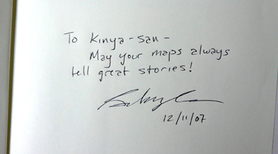
当日持参していた「GOOGLE MAPS HACKS」本にサインしていただきました。 スカイラーさんのサイン「May your maps always tell great stories!」 このOSGeo東京ミーティングへの参加でOpenStreetMap熱がさらにあがりました。 スカイラーさんとOSGeo財団日本支部に感謝します。 osgeo2007


OSMへ参加して13年、Active mapping daysが3月に3000日となります。 カウントダウン的にマッピング3000日を記念してOSMに関わる出来事についてふりかえり日記を書いています。 マッピング日数はPascal Neis氏の “How did you contribute to OpenStreetMap?”を参考にしています。Pascal氏に感謝します。

Posted by pnorman on 5 February 2021 in English.

Dear all,

Today, v5.3.1 of the OpenStreetMap Carto stylesheet (the default stylesheet on the OSM website) has been released. There are no visual changes in this release.

Changes include - Natural Earth URL changed to directly point at the NACIS CDN - Added an option to the external data loader to grant SELECT permissions on the tables

For a full list of commits, see https://github.com/gravitystorm/openstreetmap-carto/compare/v5.3.0…v5.3.1

As always, we welcome any bug reports at https://github.com/gravitystorm/openstreetmap-carto/issues

Posted by Supaplex on 5 February 2021 in English. Last updated on 6 February 2021.

During the OpenStreetMap x Wikidata monthly meetup, we decide the person who abuse the data from Facebook MapwithAI project, the user whose account starts with c, his contribution of road data that has not been touched will all be removed. MapwithAI have trouble recognized dry creek as road, or recognized high-voltage power line as road. Manual judge by human mappers is still needed.

Despite complains from OpenStreetMap mappers, there are Rudy Map users or foreign hikers in Taiwan complain about strange mountain road that seems appears from no where. It is time that OpenStreetMap communities should interfere, otherwise that will be huge amount of low quality data import into OpenStreetMap.

We have to observate that person if he will be upset and revert back his edit. If this is the case, it is time that Data Working Group to deal with.

Location: Shuanglong, Xinyi Township, Nantou County, 55382, Taiwan
Posted by LySioS on 4 February 2021 in French (Français). Last updated on 5 February 2021.

Je copie-colle ici les modifications apportées dans la page wiki


Une zone où le bâti n’a pas encore été importé peut se repérer de différentes façons. La plus évidentes est votre connaissance du terrain. Cela peut aussi se faire grâce à l’imagerie satellite ou au cadastre. Il arrive que le cadastre soit plus à jour que la BDOrtho.

See full entry

週一的月聚上,決定把濫用 MapwithAI 資料的 c 開頭使用者,他編輯的資料只要沒有動過的,版本是 1 的道路都移除掉。太多把乾溪谷辨識為道路的狀況。而在都市裡頭,則是沒有建築,陰影處辨識為巷弄,但實際上並沒有巷弄,比對 NLSC Open Data 版本之後也沒發現有巷弄。

繼續查下去,上次他在 12/31 的編輯也弄了一堆 MapwithAI 的道路資料進來,也該好好檢視狀況。他怎麼那麼有自信 AI 判斷都對,已經有不少狀況如前面提及的乾溪谷,還有高壓電塔下面,都會誤判是道路。需要人工判斷是否是道路,也是人類編輯需要介入的時機。

目前除了圖客的抱怨之外,已經有魯地圖的使用者,以及在台灣爬山的外國人,抱怨 OpenStreetMap 圖資出現奇怪無來由的山區道路。這時候 OpenStreetMap 社群需要介入,免得誤判的資料大量進來 OpenStreetMap,社群有限的人力無法好好審核導致圖資品質大幅下降。

接著就看這位人兄,是否會不爽然後又恢復他的編輯,如果到那一步就有 Data Working Group 介入的時機了。

Location: 鹿蒿, 新城村, 魚池鄉, 南投縣, 55542, 臺灣
Posted by ikiya on 4 February 2021 in Japanese (日本語). Last updated on 6 February 2021.

OSMを知る以前、誰もが作れる自由な地図を必要と感じたのは、新潟県中越(2004年)などの報道に不明瞭な地図が多く使われている状況を見たときでした。現地と状況がわかる者から情報を集約してより正確な地図は市民レベルでも作れるし、共有できるはずだと感じていました。 「新潟県中越地震が発生した際に細切れに出てくる情報を繋げてやりたいと思いました。べースマップ、基図さえ開放してくれれば瞬間的に入力できると思っていました。」と2008年のtalk-jaでその時の気持ちを書いています。

そして2007年、田舎の勤め先で開けたメールマガジンの巻末「編集便り」で初めてOpenSteetMapと出会いました。最後の一文でノックアウトされました。そのときめきは今でも覚えています。


2007/02/22 発行 「GIS NEXT EXPRESS Mail Magazine vol.105 」 株式会社ネクストパブリッシング GIS NEXT編集部  (編集部便り より引用)

“だが、このプロジェクトの面白さは地図をめぐる権利問題にとどまらないものがある。つまり、“地図は自分で作るもの”という文化が、こうした活動を通じて広がっていくかもしれないということである。情報技術の進歩によって、地理情報や位置情報の取得、処理、加工、流通が容易になったため、これからは市民が必要な地図を(コミュニティを通じて)自分で作成し、紙や携帯電話やカーナビなどに入れて利用する時代がくるかもしれないということだ(もちろん、より専門的な用途に向けた高精度な地図への需要はなくならない)。しかも、地図作成のプロセスにおけるジオコミュニケーションの楽しさは、さらに多くの人々を地図の世界に呼び寄せていく可能性がある。 その意味で、日本にもOSMのコミュニティができないかと思っている。誰か、始めませんか?”


2007年からOpenStreetMapプロジェクトへ参加して13年、Active mapping daysが3月に3000日となります。 カウントダウン的に、マッピング3000日を記念してOpenSteetMapとの出会い、人との出会い、OSMに関わる出来事について日記を書いています。 マッピング日数はPascal Neis氏の “How did you contribute to OpenStreetMap?”サイトを参考にしています。Pascal氏に感謝しています。

Resources of OpenStreetMap Foundation (OMSF), OSMF Local Chapters (LC): the question and status of paid services.

In the context of the community consultations phase of OpenStreetMap Uganda (see email 1), Poland (see email 2) and Japan (see email 3) Local Chapter LC applications, I shared my thoughts about paid services as a means of resources for OSMF and LCs. I have been invited to start a discussion of its own about this topic, hence this note.

I orginally developped this topics as well as others in the context of the MapUganda application which read as an email (see email 4) and a diary note (5) .

Since I think it makes sense to also discuss the status of paid services as a resource for OSMF and LC generally outside of a specific context, I am producing below the section on this topic extracted from my MapUganda-related email/note (4,5).

== Email extract - start ==

We shall first look back at OSMF and LC and remind ourselves of the early ages of the OSM project when its ecosystem was nascent and review some of the strengths that lead to its current affirmation.

Frederik’s question (see email 6) brings us with the non written rule or the jurisprudence behind the practices under which OSMF and LC from “developed” countries have been functioning resources-wise so far: banning paid services from their resources.

This is true at OSMF and this is equally true in given LC like OSMFR where this banning of “paid services” from the actual resources of the association is collectively restated year after year at its AGM.

See full entry

Over the past few months HOT has been working in partnership with NESTA Collective Intelligence grants and 510 at the Netherlands Red Cross to implement an experiment to test the efficiency and efficacy of AI assistance on remote mapping of buildings.

The experiment is designed to compare the results of traditional remote mapping workflows (editing in ID Editor) with emerging AI assisted workflows (editing with RapID). To do this, we will be conducting mapping experiments of two locations (Uganda and US), with two different levels of mappers (beginner and advanced) using the two different remote mapping workflows (RapID and ID).

To this end, we are looking to run four experimental groups with > 50 people each, as follows: Beginner Mapathon - Uganda data Beginner Mapathon - US data Advanced Mapathon - Uganda data Advanced Mapathon - US data

Each mapathon will be a total of two hours, with participants being randomly assigned to map building footprints with either ID or RapID prior to beginning their mapping. Data will be gathered on the existence of map features, completeness of mapped features and similarity of map features, when compared with an OSM reference dataset.

For the mapathons we will be using convenience sampling from our networks by generating a public call for participants.

You can sign up to participate in the experiment here >

Kindness,

bo

Location: Naz, Esserts-Salève, Monnetier-Mornex, Saint-Julien-en-Genevois, Upper Savoy, Auvergne-Rhône-Alpes, Metropolitan France, 74560, France
Posted by c tito young on 3 February 2021 in English. Last updated on 11 March 2021.

A geoglyph of a Flying Pelican 125m x 100m depicts the bird heading west.
The shape reveals a pelican diving for food, revealing a side view of a head, eye, pouch like beak, wings, tail, body and two feet. There is a long geoglyph of a single 125m line that suggests under the pelican that there is the ocean surface.. In regards to details provided by the artist and seen from satellite, the pelican’s pouch appears properly scored, with a hook at the very tip of its beak.

Location: Nasca, Province of Nasca, Ica, Peru
Posted by ikiya on 3 February 2021 in Japanese (日本語).

2007年からOpenStreetMapプロジェクトへ参加して13年、Active mapping daysが2970日を越えました。あと30日で3000日となります。カウントダウン的に、マッピング3000日を記念してOpenSteetMapとの出会い、人との出会い、OSMと私に関わる出来事について日記を書いていこうと思います。

マッピング日数はPascal Neis氏の “How did you contribute to OpenStreetMap?”サイトを参考にしています。Pascal氏に感謝しています。

Posted by apm-wa on 3 February 2021 in English.

The survey now offers 18 languages (Arabic, Chinese (Traditional; Taiwan), English, French, German, Indonesian, Italian, Japanese, Korean, Kurdish (Sorani), Persian, Polish, Portuguese (Brazilian), Russian, Spanish, Turkish, Ukrainian, Vietnamese).

As of today (3 February) the survey has received 2381 full responses and 962 incomplete responses, for a total of 3,343 responses. A total of 3,875 tokens have been requested.

Responses are predictably tapering off from the peak of 461 on 23 January (the day after a banner went up on osm.org), but remain relatively high with over 100 responses daily. The survey will remain open until February 14th, so if you have not taken it yet, please give the OSM Foundation five to ten minutes of your time to share your opinions!

https://weeklyosm.eu/ru/archives/14235 Рис. Петер Бергер считает, что швейцарское OSM-сообщество могло бы сделать слой с картой для туристов. Он оформил некоторые предложения по стилю, и в швейцарском списке рассылки идёт дальнейшее обсуждение.

  • Кристофер Беддоу опубликовал пост с историей MAPS.ME, а также описанием последних событий.
  • Вильям Рей использовал различные источники данных, в том числе и OSM, для генерации карты пешей доступности инфраструктурных объектов в Оксфорде.
  • Maptiler пишет о MapLibre — форке библиотеки Mapbox GL JS, который появился после изменения лицензии на несвободную.
Posted by c tito young on 2 February 2021 in English. Last updated on 11 March 2021.

This 20m x 50m geoglyph depiction of a standing monkey has his head turn to the west. He is oriented in the north to south and admist groups of Nazca lines on this flat topography. It is completely unclear what he is doing or what the artist intended monkey to be representing.
In the westerly direction of which the monkey was viewing, 3000m away is where Rio Nazca intersects a stream. (Suggesting a village location)

Location: Cahuachi, Nasca, Province of Nasca, Ica, Peru

The humanitarian OpenStreetMap community working group is looking for interesting panellists for a webinar mini-series on Colonialism in Open Data and Mapping. Do you have any suggestions?

This is the explainer for the webinar:

“And while maps may be missing from digital platforms and social networks, we are still here.”- David Garcia, 2020

Maps and digital data have played crucial roles in humanitarian aid eg. disaster response. Although it is of best interest to help local communities through generating data and features on the map, humanitarian actors and mappers should take note that we are not only mapping features (houses, roads, waterways, etc), but also mapping the land, oceans, and communities who live and are stewards of that space. With this webinar, we want to examine and discuss this balance (community <> digital information), decolonising open data and open mapping, and representation and power in humanitarian mapping, among others.

There will be two events in this series that hopefully accommodate interested people in different timezones : 26 Feb 2021 at 06:00 & 16:00 UTC.

Our panel so far for the 06:00 UTC event are:

And, for the 16:00 UTC event:

We are looking for one more panellist for each event. If you would like to suggest someone, please feel free to get in touch via the comments or the community-wg slack channel or via email at pete.masters @ hotosm.org

For more info on the webinars that the WG organises, there is a wiki page, here.

For more info on the working group, there is a wiki page, here.

Yesterday I replaced diplomatic=consulate_general by diplomatic=consulate with consulate=consulate_general over 400 objects (266 nodes, 131 ways and 3 relations) all over the World (see osm.org/changeset/98531944).

With the release 4 days ago of the v5.3.0 of openstreetmap-carto (see https://github.com/gravitystorm/openstreetmap-carto/blob/master/CHANGELOG.md) “amenity=embassy is no longer rendered, and office=diplomatic with diplomatic=embassy or diplomatic=consulate is instead (#4168)”. Therefore the diplomatic=consulate tag becomes very important.

As we “don’t tag for the renderer”, don’t consider this news as an argument but as a bonus in my motivation for doing the switch.

Let me detail the reasons why I did it:

I also would like to highlight that this tag is a minor one: it’s only a complementary tag giving more details with office=diplomatic.

Feel free to give me any feedback about this move.

See full entry

Posted by c tito young on 2 February 2021 in English. Last updated on 11 March 2021.

The geoglyph of the alligator attacking a swimming man 100m wide x 40m long is oriented east (head) to west (tail) on moderately sloped land. It appears to be chasing a person trying to swim away approximately 15m from its mouth also oriented east to west.

The artwork indicates the alligator with a slightly open mouth targeting the swimmer that is directly in front of him.

Location: Acarí, Province of Caravelí, Arequipa, Peru