这次回美国, 我每处专门都用OSM比较, 发现即使在OSM的诞生地, 以及大量互联网使用者, GIS从业者的美国, 非盈利性质的OSM其细化也远远比不上商业化的谷歌地图. 之前我觉得OSM详细, 是因为目光都聚集在了主要公共设施, 比如广场, 公园, 车站, 知名景点. 这些地方OSM的编辑者自然多, 但是下至中小型乡镇, 其覆盖率是真不高. 不过话说回来我在之前看OSM的热点上, 美国也不是极高值. 绘制最多的那块在德国, 瑞士, 意大利, 法国, 波兰等中西欧国家, 不知道那里等实际情况如何.
Users' Diaries
Recent diary entries

About me

I started mapping in June 2020 as a way to find parks and trails near my home in Redmond, Washington. My daughter loves adventures and provides huge motivation. I am a former compiler engineer and bring a passion for great tooling. I love being able to work with others on an expansive, vivid, and important project.
My mapping

2025年1月自從參加完台灣維基媒體的年度大會後,我就想說找時間來完善馬祖的地理資訊和百科條目內容。
complete guide of uploader https://help.mapillary.com/hc/en-us/articles/360020825811-Mapillary-Desktop-Uploader-the-complete-guide
Insta 360 X3 (但我用X2) https://help.mapillary.com/hc/en-us/articles/11951588568604-Insta360-X3
Posted by TrickyFoxy on 31 January 2025 in English.
Last updated on 2 February 2025.

Today I will talk about the new version 0.8 of userscript that adds several useful features to osm.org.
You can view existing features of the script and install it on GitHub or in the OSM Wiki
⚡️ Faster rendering
My first PR was merged to openstreetmap-website code, and now the Map Data layer loads instantly. Be sure to try it. Thanks to the maintainers for help!
For the script, this means a huge acceleration in rendering large relations and GPS tracks (yes, tracks, read more!):
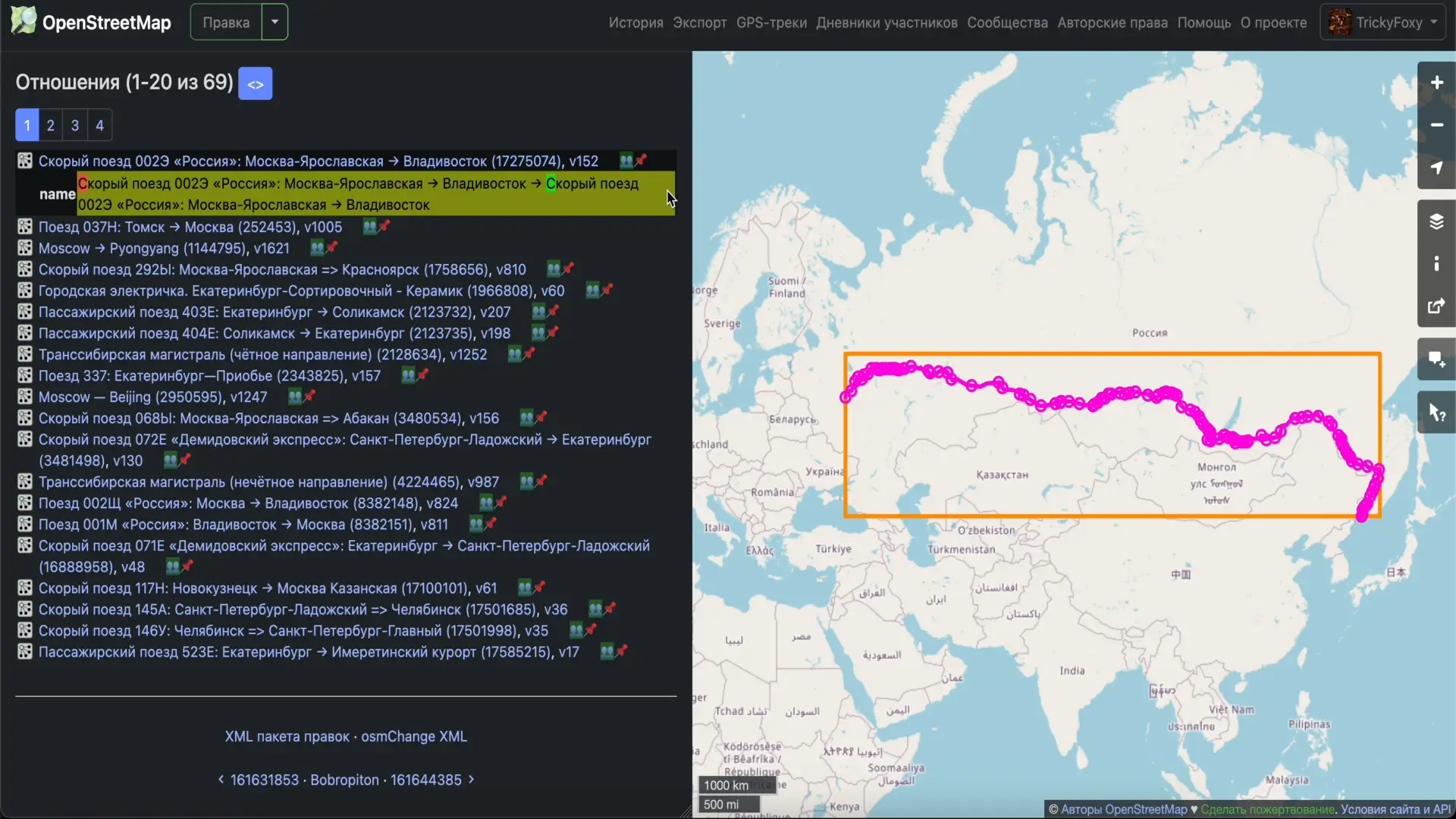
icon 👥 near relations is clickable 😉
📸 Photos from Panoramax, StreetComplete, Wikipedia Commons
Now they are displayed directly on the website. In notes, in tag history, and in changesets.
Épicerie coopérative

Merhaba arkadaşlar, Antalya bölgesini düzenleyeceğim. Harita API’sinde koordinat ve isim ekleme özelliği var mı? Eğer varsa, çok basit bir şekilde tüm ülkeyi Google Places ile eşleştirebilirim.
한국에는 아직 오픈소스 및 사용자 기여에 대한 활발한 환경이 갖추어져있지 않다. 하지만 그러한 문화에서도 여러가지 변화가 있는데, “나무위키” 서비스이다. 한국어와 한국 사용자 위주로 갖추어져있는 나무위키는 대부분의 사용자가 간단한 로그인만으로 위키 글에 기여할 수 있는 온라인 플랫폼이다.
오픈스트리트맵에 기여하는 한국인 사용자로서, 한국에서 더욱 활발한 사용자 참여가 있도록 여러 가지 방법을 생각해보고 있다.
그 중, 내가 처음 시도하는 것은 위치 기반 서비스 어플 출시이다. 필자는 연세대학교 학생으로,
연세대학교 서쪽 구역인 소위 “서문” 지역을 기반으로 하는 앱을 제작하고 있다.
이 앱은, 학생을 위한 카페 및 음식점 연결, 학생끼리의 소개팅이나 미팅 주선, 나아가서는 지역 사회를 기반으로 학생 창업 문화를 증진시키고자 하는 목적을 가지고 있다.
오픈스트리트맵을 활용하므로서, 모두가 기여하며 효과를 받을 수 있는 오픈소스의 가능성을 연세대학교에서 시작하고자 한다.
(ios 기반으로 앱을 제작중이며, 2025년 2월 중순 이내로 앱스토어에 등록할 예정이다.)
After reading this article How to transform data from NAD83 to WGS84 and based on my personal experience (taking RTK GNSS measurements with multi-frequency multi-constellation receiver hooked up to ORGN NTRIP caster referenced to NAD83(2011) epoch 2010.00), I want to share some notes.
The article suggests QGIS as a tool just to proceed with warning potential users how it could easily go wrong with no warnings. However, it doesn’t provide any methods to verify the results or the method itself except for trusting the process. Since my first attempts (independent from the content of the article) to transform my observations have failed, I was looking for the verification method and found some.
First of all, as far as I understand QGIS uses GDAL/ORG and PROJ. This toolchain has a very useful command projinfo for testing the transformation. You’d need to understand WKT output that it will spit out, but you can much easier spot the situation when it’s going to use a ballpark low-precision transformation.
For instance, this query:
projinfo -s EPSG:6319 -t EPSG:7665
among many other things spits out this string:
Conversion from NAD83(2011) (geog3D) to NAD83(2011) (geocentric) + Inverse of ITRF2008 to NAD83(2011) (1) + Inverse of WGS 84 (G1762) to ITRF2008 (1) + Conversion from WGS 84 (G1762) (geocentric) to WGS 84 (G1762) (geog3D)
It explains in fairly good detail what it’s going to do and has some useful keywords such as geog3D which means that it expects input and provides output in degrees of latitude/longitude as well as ellipsoidal height, see EPSG:6319 for details. It also mentions 0.01 m at the beginning and in the context of OPERATIONACCURACY[0.01] which is pretty self-explanatory.
Then, you can actually attempt transforming an individual set of coordinates using cs2cs. The easiest way is to throw them into its input stream like this using echo:
Cycling is not one thing
To most people cycling is just something people do as exercise and if you’ve seen one bike you’ve seen them all. To someone that has become deeply embedded into the cycling community at a national level as my hometown area has become a cycling hub for every variety of biking there is my view of biking has become quite diverse and how I’ve approached mapping cycling has matured and grown. I think a lot of people within the OSM community look at osm.wiki/Bicycle and scroll through pages and think, man it looks like you’ve got is all covered. However, I see this page I almost entirely see one type of cycling covered: Urban/Suburban Commuting.
So maybe a good place to start is to cover the variety of types of cycling that exist and how they are distinct and how they are also tangibly intertwined.
Even in listing these I tried to stop and logically break things in to categories like on-road, off-road, and closed circuit or hard-surface vs. soft surface of even high speed (sport) vs. low speed (recreation/commuting) but even here these starts to bleed together. For instance MTB racing has started to include gravel runs, so has cross country (XC), so has the Tour de France which is decidedly road.
Thus in no particular order here are some of the larger categories of biking and at a high level difference in how they function as it relates to biking.
Road Biking
Think tradition asphalt, curved handle bars, Lycra , fully human powered, and fast. From a mapping perspective this requires a lot of similar things to road mapping like speed limits but there is a particular interest in if roads have shoulders or if it’s an established mountain road that people train then there can be little difference.
Mountain Biking (MTB)

The twenty-third development diary brings substantial architectural changes to OpenStreetMap-NG, marking a pivotal moment in the project’s evolution. This update introduces MapLibre GL JS as our new mapping engine, comprehensive dark theme support, and various quality-of-life improvements that enhance both user experience and technical capabilities.
🔖 You can read other development diaries here:
osm.org/user/NorthCrab/diary/
⭐ This project is open-source — join us today:
https://github.com/openstreetmap-ng/openstreetmap-ng
🛈 This initiative is not affiliated with the OpenStreetMap Foundation.
Video Summary
Feel invited to watch this video summary that demonstrates improvements in action. The showcase provides a look at the new MapLibre GL JS integration, dark theme functionality, and various interface refinements that enhance the OpenStreetMap-NG experience.
⬇ Click the image below to play
Hello OSM Community,
I’m still working on capturing 360° images of the city of Salzburg for Mapillary and Panoramax. My goal is to enhance OSM data in Salzburg, especially in areas with notes that could be resolved with better visual context - something 360° images can provide.
Progress as of now

Route Planning Challenges
So, i tried some tools to plan a route efficiently to cover as many streets as possible without overlapping - essentially the Chinese Postman Problem.
- Bikerouter: manual tedious labour involved to cover every street
- everystreet challenge: no GPX download, so useless. No developtment.
- RunEveryStreet: More automated approach, but key features missing and some bugs, and I didn’t get a response to my suggestions unfortunately.
Unfortunately, none of these tools fully met my needs, so i did it more practical.
The Solution I’m Using
Posted by Bayazid Ahmed on 25 January 2025 in English.
Last updated on 27 January 2025.
“Mapping USA 2025” welcomed participants to join virtually via Zoom for the two-day event between January 24th-25th with times from 11 AM to 3 PM ET. 🌍✨

Hey guys! My first time giving diary entry in OSM!! Very incredible.
به مدت ۲۵ سال در مدارس مختلف استان البرز، خاصه در منطقه ساوجبلاغ با سمت مدیر فعالیت داشتم، باتوجه به حفظ ارتباطات عاطفی خودم در طول سالهای عمر، مخصوصا بعد از بازنشستگی، از ظرفیت بکار گیری و همراهی عده ی زیادی از شاگردانم در امور اطلاع رسانی، نقشه خوانی و نقشه برداری، جمع اوری اطلاعات دقیق اماری مخصوصا ازنقاط محروم و کمتر رشد یافته را دارم
Posted by Emils Mikelsons on 24 January 2025 in Latvian (Latviešu).
Jau dažus labus mēnešus strādāju pie Zemītes un tās apkātnes uzlabošanas.
Mērķi
Padarīt karti detalizētāku un precīzāku- pievienot kokus, izlabot māju kontūras, izveidot jaunas, iepriekš nekartētas ēkas, pievienot grāvjus, jaunus ceļus, izveidot katram nostūrim apzīmētu apgabalu kā lauks, krūms, zāle, mežs utt.
Kas izdarīts?
Līdz šim esmu pabeidzis kartēt divus apgabalus- izdarīts ir viss, ko iepriekš minēju.
 )
)
Bet kāpēc?
Kāpēc ne? Varbūt kādam nākotnē noderēs.
I currently live in Chhattisgarh.
1) Sentiero 801: Sa Pala de Cunventu - Is Seddas de Trebini, (Agro Sinnai)= mappato. 2) Sentiero 802: Cunventu - Bruncu Poni Fogu, (Agro Sinnai) = mappato. 3) Sentiero 803: Bau Arrexini - Bruncu Monti Eccas, (Agro Sinnai)= mappato. 4) Sentiero 804: S’Incantu - Campu Omu Arcu Arriu Longu, (Agro Sinnai)= mappato. 5) Sentiero 805: Arcu Is Pedras Biancas - Arriu Sa Scova Mara Solinas, (Agro Sinnai)= mappato. 6) Sentiero 806: Arcu Sa Spina - Arcu Su Crabiolu, (Agro Sinnai)= mappato. 7) Sentiero 807: Bau S’Acua Callenti - Baccu sa Figu, (Agro Castiadas)= mappato. 8) Sentiero 403: Sa Pala de Su Scoffu - San Gregorio, (Agro Burcei - Sinnai)= mappato. 9) Sentiero 800A: Sa Sedda de Tullinu - Sa Guardia de Tullinu, (Agro Sinnai)= mappato. 10) Sentiero 800B: Arcu Fra Contini - Sa Ruxi de S’Arridelaxiu, (Agro Sinnai)= mappato.
Posted by Bayazid Ahmed on 23 January 2025 in English.
Location:
Dogormora, Savar, Savar Subdistrict, Dhaka District, Dhaka Division, 1340, Bangladesh

i left the city
Last time i was in the city, went for coffee and made a post here about it. Now i dont see any post…
digital hallucination
Now im writing from a remote location artist studio. Should i pin it on the map? kontajnerlab
Posted by Tex2002ans on 22 January 2025 in English.
Last updated on 23 January 2025.
In the upper-right corner of the main screen, you’ll see 3 buttons:
- Upload
- Looks like an “up arrow”.
-
Layers
- This is the one we want!
- Settings
- Looks like “3 horizontal lines”.
(Note: This tutorial was created using StreetComplete v60.1 on Android.)
Tutorial: Adding Fire Hydrants

1. Click on the “Layers” button.
2. Choose “Things”.
- The icon will now turn into a green-and-white bullseye-looking symbol.
- (You can now see objects like benches / fire hydrants on the map.)