Users' Diaries

Recent diary entries

Posted by Jinoytommanjaly on 28 May 2024 in English. Last updated on 10 June 2024.

Magical world of mapping through OpenStreetMap and Wikidata

The possibilities for integration between these two platforms are incredibly vast, and I genuinely feel as if I had progressed quite a lot in the understanding and contributions I make

Date: May 20, 2024

I started my morning by getting familiar once again with OSM. I invested time in updating and linking the wards in Kerala with Wikidata. I noticed that there was some wards in OSM that are not linked to Wikidata and some issues with the names and ward numbers. Using Sparql query I downloaded the Qids from Wikidata and using QGIS I downloaded the OSM relations ids. Then using OpenRefine I reconciled the data and matched the OSM and Wikidata entries. Using JOSM, I added the Qids to OSM relations.

” Ferramentas de Boas Vindas no Openstreetmap”

Olá a todos os Mapeadores Brasileiros.  Teremos uma oficina com o Angoca da Colômbia amanhã, dia 28 de Maio de 2024 para mostrar como se usa a ferramenta de boas vindas para novos mapeadores e como convidá-los para a comunidade brasileira do openstreetmap e os grupos locais. 

Palestrante Angoca - Colômbia.Mediadores

Raphael de Assis - Umbraosm - Brasil.

Mediadores - Rodrigo Smarzaro - Youthmappers - Brasil.

Data: 28 de Maio de 2024. hora: 19:00hs - UTC-3 Horário de Brasília. 

link da Oficina: https://www.youtube.com/watch?v=4EYc5Rh5L5s

A Oficina é aberta a todos que querem aprender a usar essa ferramenta para dar boas vindas aos novos mapeadores em todo o brasil e no mundo. Ferramenta https://welcome.osm.be/

Atenciosamente,

Raphael de AssisPresidenteUMBRAOSM - União dos Mapeadores Brasileiros do Openstreetmap  site da UMBRAOSM, www.umbraosm.com.br contato@umbraosm.com.br 

Location: Boa Vista, Recife, Pernambuco, Região Nordeste, Brasil
Posted by Juicio on 27 May 2024 in English. Last updated on 24 August 2024.

Panoramax

Panoramax view feature improves map exploration and gives users access to 360-degree imagery that enhances the mapping process and gives important visual context.
The community gains access to a potent tool that improves map visualization and encourages increased engagement and participation in the mapping process.
Live images can provide a lot of information that can be hard to determine, such as the weather or the terrain condition.

Introduction

Hi I’m Mattia, one of the Google Summer of Code 2024 contributors. This journal will be updated weekly based on what is happening. If you want to see how streetlevel layers work you can check out a guide here.

Milestones

Important and mandatory Milestones

  1. Design how to add Panoramax in iD, understand how image retrieval works and how best to implement it.

  2. Write the new Panoramax layer in iD.
    • Codify the functionality of the basic layer
    • Viewing normal Panoramax photos
    • Displaying 360-degree Panoramax photos.
  3. Add functionality to the layer.
    • Add filters for username, photo type and date (like Google Maps does if it has multiple images of a place).
  4. Integration with other UI elements.
    • Paste the id of the photos into the OSM tag.
    • Modify the UI to make it easier to enable all accessible street-level image layers in a given area (e.g., “enable all” button for street-level layers).

At each stage: write documentation, write tests, fix bugs, and check that everything is implemented correctly.

Results

Everything that has been done is avaiable at this link. Open the sidebar -> click “Map data” -> “Streetlevel” -> “Panoramax” (you’ll need to zoom in quite a bit to be able to activate the layer).

You can also check the code here.

Check the Pull Requests here

See full entry

Posted by RinchenNorbu on 27 May 2024 in English. Last updated on 9 June 2024.

Introduction

My name is Rinchen Norbu, and I am from Bhutan. I hold a B.Sc degree in Geography, which has endowed me with extensive knowledge in GIS and Remote Sensing, sparking a deep interest in further GIS studies. My foray into the world of OSM began on March 18, 2023, marking my initial venture into this domain. My introduction was through a project focused on mapping hospitals and Basic Health Units in Bhutan, led by a Bhutanese woman as part of the She Leads She Inspire challenge. I am grateful to Ms. Kelzang Yuden and her team for this opening. Additionally, my gratitude extends to Ms. Leki Choden, who motivated me to become part of her mapping team. Since then, I have been regularly following the Asian Pacific Hub and Mr. Mikko’s Facebook page for the latest OSM updates.

Upon discovering the announcement about the OMGuru fellowship, I was thrilled and promptly sat for the OMGuru examination in the first week of November. After successfully passing the exam, I was chosen to partake in the fellowship. The fellowship is divided into three streams: 1. Training Fellowship, 2. Mapping Fellowship, and 3. Validation Fellowship. Recognizing my unique strengths, I was appointed to the Mapping Fellowship. It appeared that I was the sole representative from Bhutan in this fellowship, as I did not come across any other Bhutanese names. I have committed myself to the Mapping Fellowship for five months.

During Fellowship

Throughout my experience with the Omguru mapping fellowship, I have gained a wealth of knowledge in OSM mapping, as well as familiarity with various new mapping tools and software. In addition, I have had the chance to participate in a sequence of webinars that delved into topics such as mapping, data exportation, and mobile mapping applications, including Mapillary, Every Door, MapSwipe, and MapRoullete.

See full entry

Location: BPC Colony, Phaling, Jang_Ngar, Gangzur Gewog, Lhuntse District, Bhutan

Para saber dónde ha contribuido un usuario, se pueden usar herramientas como hdyc o yosmhm. Son muy buenas para ayudar a identificar personas que trabajan en la misma ciudad o país, e invitarlos a que participen de mapathones, mapping parties o inclusive geobeers. Esas herramientas se basan en las contribuciones directas en el mapa que ha hecho la persona. Pero no son las únicas formas de contribuir, también están las notas y las trazas GPX capturadas.

Debido a que el API 0.6 no ofrece una forma de descargar las trazas de un usuario dado, no hay una forma directa de hacerlo. Para eso yo creé un script para correrlo en Linux, donde se le indica el nombre de usuario, y descarga las trazas de ese usuario.

Una vez descargadas las trazas, se pueden abrir en JOSM y revisar las áreas de contribución. Este script también es útil para descargar las trazas después de un trabajo en terreno con OSM Tracker con varios usuarios.

El script lo dejé en GitHub gist: https://gist.github.com/angoca/dff941220631dace54901a3fec3de9df

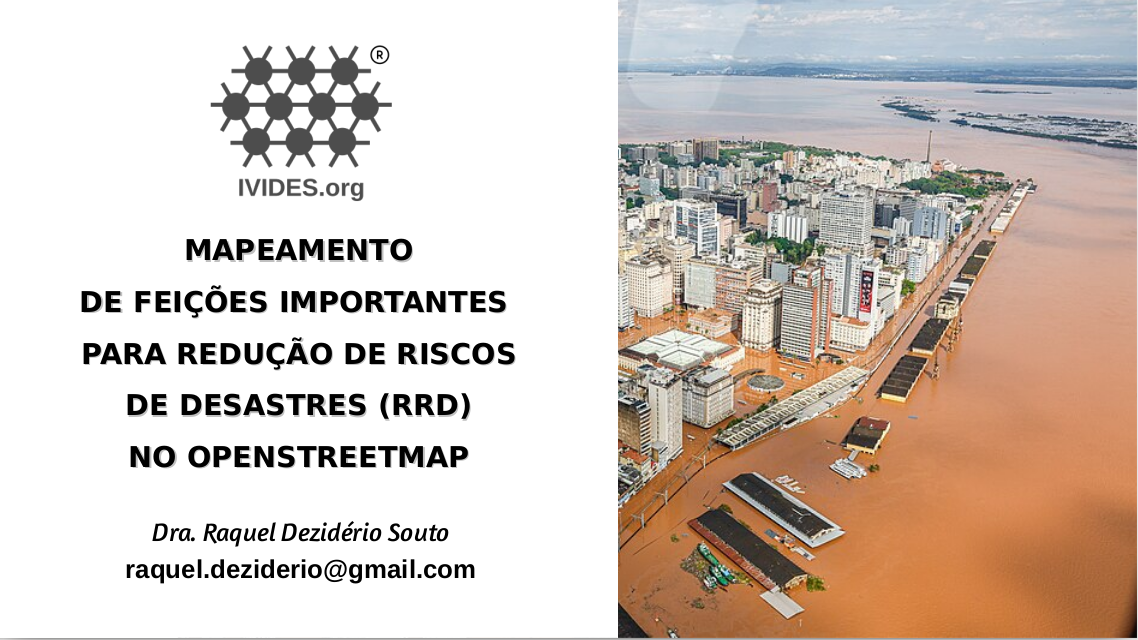
IVIDES.org promoveu oficina para disseminar a importância dos dados e softwares abertos no contexto humanitário


O Instituto Virtual para o Desenvolvimento Sustentável - IVIDES.org promoveu uma oficina sobre mapeamento de feições importantes no contexto da redução de riscos de desastres, utilizando o OpenStreetMap, a maior base cartográfica colaborativa da atualidade.

https://ivides.org/wp-content/uploads/2024/05/capa_yt_oficina4.png

Na oficina, foram mostrados os conceitos relacionados ao contexto de desastres e mapeamento colaborativo; as principais características, vantagens e limitações do OpenStreetMap e de programas relacionados; uma lista preliminar de etiquetas a serem consideradas; além de dois estudos de caso de desenvolvimento de mapas web com uMap - mapeamento de infraestrutura para RRD em Maricá (RJ, Brasil) e mapeamento para apoiar as ações humaniárias relacionadas ao desastre em curso no Rio Grande do Sul (Brasil).


Na página das oficinas temáticas, encontram-se todos os recursos e a agenda.

See full entry

Location: Centro Histórico, Porto Alegre, Rio Grande do Sul, Região Sul, Brasil
Posted by Brazil Singh on 25 May 2024 in English. Last updated on 27 May 2024.

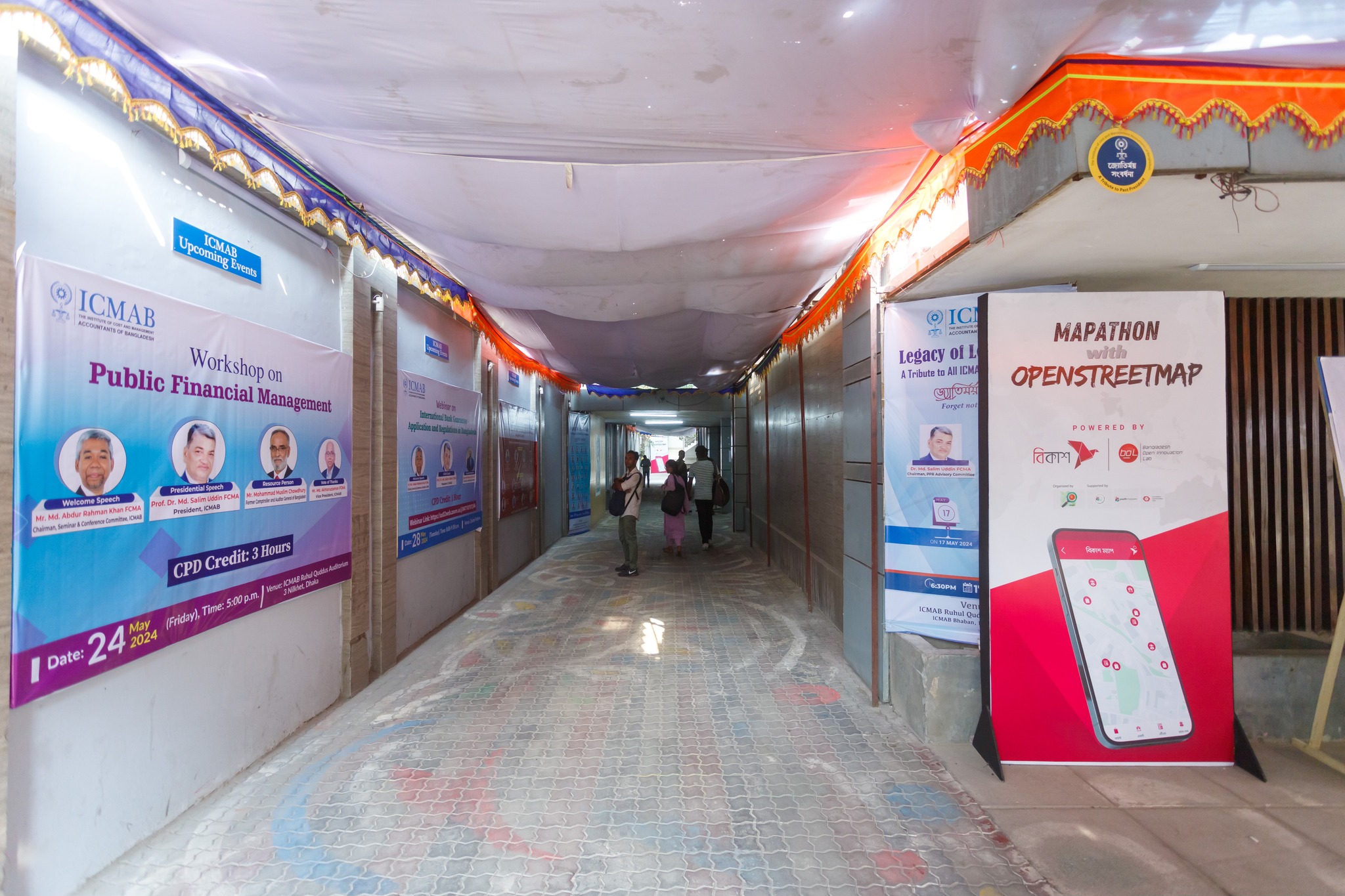
On May 24, 2024, OpenStreetMap Bangladesh Community organized a mega mapathon in Dhaka at ICMAB Training Center, Annex Building, Nilkhet Road, Kataban, Dhaka . OSMBD MEGA MAPATHON LOCATION

It was an amazing day. The event started at 09:00 am and ends at 4:00 pm with so many workshop, quiz, mapathon.A team from Rajshahi University joined with us virtually.

See full entry

Posted by jmbatchelor on 25 May 2024 in English.

A trip to Wisley and I noticed that the new Clear Lake was not mapped at all. I only managed to walk around one side so it could do with some adjustment I’m sure. The Glass House Border has been re-landscaped into The Oudolf Landscape with new paths - I didn’t get the chance to map these, but hopefully someone will in the future.

Location: Wisley, Guildford, Surrey, England, United Kingdom

Esse texto é uma sugestão de etiquetagem da vegetação natural brasileira como classificada pelo Instituto Brasileiro de Geografia e Estatística (IBGE) em seu Manual Técnico da Vegetação Brasileira. É uma expansão e atualização do meu diário anterior em que proponho uma forma de mapeamento da Caatinga. O intuito é ser um suporte para quem tiver interesse em mapear áreas vegetadas no OpenStreetMap sem a necessidade de criação de novas tags e utilizando o que já está documentado na Wiki. Já esclareço de início que as tags disponíveis no OSM são muito limitantes para o mapeamento ambiental e, portanto, algumas liberdades foram tomadas. Além disso, o sistema de etiquetagem não pode ser muito complexo porque pode desmotivar o mapeamento por mapeadores iniciantes.

🌴 Sugestão de classificação da vegetação quanto ao porte (altura) 🌴

Para essa proposta, adaptei o que está descrito na Wiki acerca de Vegetação e vejo que quatro valores da tag natural ordenados em grau de porte (altura) seriam úteis. Resumidamente, os valores em ordem decrescente de porte são:

natural=wood > natural=scrub > natural=heath, natural=grassland.

🌳 Etiqueta natural=wood

See full entry

CNEFE: IBGE anticipates address registration microdata to assist managers in Rio Grande do Sul

CNEFE: IBGE anticipates address registration microdata to assist managers in Rio Grande do Sul The IBGE released, this Tuesday (21), in advance, the microdata from the National Register of Addresses for Statistical Purposes (CNEFE). The measure is another effort by the Institute to make available, as quickly as possible, information that can help with the calamity situation faced by Rio Grande do Sul. Full disclosure will be on June 14th.

See full entry

Location: Plano Piloto, Federal District, Central-West Region, Brazil
Posted by NitaRae on 24 May 2024 in English.

The NCST, in it’s current configuration, extends from a quasi center point of Wilcox Junction east to Trenton FL, west to Cross City FL, and south to Chiefland FL. All three of those terminal points have expansion plans when funding becomes available: Trenton east to Newberry FL (which connects it to Gainesville), Cross City northwest to Perry FL (and then probably on to Madison), Chiefland southeast to Dunellon FL (and the various trails currently operating in/around Citrus county).

While the trail itself is documented and mapped, there are many undocumented access points. Those access points lead to local small streets, residences, and often to local businesses. I am attempting to document those access points, so that bike riders (such as myself) can find safer ways to travel to those businesses.

The Florida Department of Transportation is working on road upgrades in my local area. Those upgrades (State Road 26 and US Highway 19/98) will include paved shoulders outside the travel lane marker line. Those shoulders allow for use by vehicles with breakdowns and for bicycles (although such use should be considered carefully in light of the speed of vehicles on the highway).

Location: Wilcox Junction, Gilchrist County, Florida, 32680, United States

Maps are invaluable tools that serve a multitude of purposes across various aspects of life. At their core, maps provide spatial context, allowing individuals and organizations to understand the geography of an area and make informed decisions. They are crucial for navigation, helping people and goods move efficiently from one place to another by providing clear and precise routes. This is vital not only for everyday travel but also for logistics and supply chain management, where accurate mapping can significantly reduce costs and improve delivery times.

Beyond navigation, maps are essential for planning and development. Urban planners, architects, and engineers rely on maps to design cities, infrastructure, and buildings. They help identify the best locations for new developments, assess the environmental impact of projects, and plan for future growth in a sustainable manner. Maps also play a crucial role in public health by identifying disease hotspots, tracking the spread of epidemics, and planning healthcare services. In agriculture, maps are used to monitor crop health, manage resources, and improve yields through precision farming techniques.

Maps are also powerful tools for communication and education. They can convey complex information in a visual and easily understandable format, making them invaluable for teaching geography, history, and science. Maps help in visualizing data trends, such as population growth, economic activity, and environmental changes, enabling policymakers and researchers to analyze and address various issues effectively. Furthermore, maps promote transparency and accountability in governance by providing citizens with accessible information about their communities and the broader world. Overall, the value of a map extends far beyond its basic function of showing locations; it is a fundamental resource for decision-making, planning, and understanding our world.

But, What If You Don’t Have Access To A Map?

See full entry

Downloads

https://umbraosm.com.br/dowloads-gis-banco-de-dados-de-link-da-umbraosm/

Os dados disponibilizados pelo Instituto AddressForAll podem ser baixados por município (dados locais) ou ao nível nacional.

Listagem dos arquivos referenciados em arquivos de configuração make_conf.yaml, ordenada por jurisdição. A cada item são oferecidos os links de download (pelo hash) e de navegação pelos metadados.

Países disponíveis: Bolivia Brazil Chile Colombia Ecuador Mexico Peru Paraguay Suriname Uruguay Venezuela

https://www.addressforall.org/pt/downloads/

https://umbraosm.com.br/dowloads-gis-banco-de-dados-de-link-da-umbraosm/

UMBRAOSM www.umbraosm.com.br

Location: Boa Vista, Recife, Pernambuco, Northeast Region, Brazil

Free Urban Mobility Courses in Portuguese!

1.Desenvolvimento Orientado ao Transporte Sustentável (DOTS)

2.Mobilidade a Pé

3.Mobilidade por Bicicleta

4.Transporte Público

5.Gestão da Mobilidade

link to sign up for the course for free! https://mobilicampus.org.br/cursos/

Post published by Umbraosm, the union of Brazilian mappers from Openstreetmap on their Blog. https://umbraosm.com.br/2024/05/23/1434/

UMBRAOSM www.umbraosm.com.br

Location: Indianópolis, Moema, São Paulo, Southeast Region, 04524-030, Brazil

Collaborative Mapping Workshop for Openstreetmap Beginners with ID Editor

On May 21st at 16:30 UTC-3, UMBRAOSM - Union of Brazilian mappers of Openstreetmap promoted a workshop for new members of Youhmappers Esalq/USP who were starting in the Brazilian chapter in the city of São Paulo - Brazil.

See full entry

Location: Paraíso, Vila Mariana, São Paulo, Southeast Region, 04002-021, Brazil
Posted by The Core on 22 May 2024 in German (Deutsch).

Wir sind in Bewegung auf der Suche nach Orten wo wir Musik hören, tanzen, Internet nutzen, Panorama Sicht geniessen und Leute anziehen, die in Freiheit mit Anstand zu Mensch, Tier und Natur leben können und wollen.

Wir haben Regeln, zum Schutz unserer Gesundheit, der Umwelt, unseres Wohlbefindens. Wer ohne Regeln leben möchte ist bei uns am falschen Platz. (wie können hier Fotos hinzugefügt werden ?)

We are on the move, looking for places where we can listen to music, dance, use the internet, enjoy panoramic views and attract people who can and want to live in freedom with respect for people, animals and nature.

We have rules to protect our health, the environment and our well-being. Anyone who wants to live without rules is in the wrong place with us.

Estamos en movimiento buscando lugares donde podamos escuchar música, bailar, utilizar Internet, disfrutar de vistas panorámicas y atraer a personas que puedan y quieran vivir en libertad, respetando a las personas, los animales y la naturaleza.

Tenemos reglas para proteger nuestra salud, el medio ambiente y nuestro bienestar. Si quieres vivir sin reglas, has venido al lugar equivocado.

Location: Haza Almayata, Los Martínez, Viñuela, La Axarquía, Málaga, Andalusien, 29712, Spanien
Posted by NorthCrab on 22 May 2024 in English. Last updated on 23 May 2024.

Welcome to the eighth OpenStreetMap NextGen development diary.

This time the diary is one day early due to how much progress has been made.
There is more than enough for me to prepare a showcase 🏋.

🔖 You can read my other development diaries here:
osm.org/user/NorthCrab/diary/

⭐ This project is open-source and publicly available:
https://github.com/Zaczero/openstreetmap-ng

🛈 This initiative is not affiliated with the OpenStreetMap Foundation.

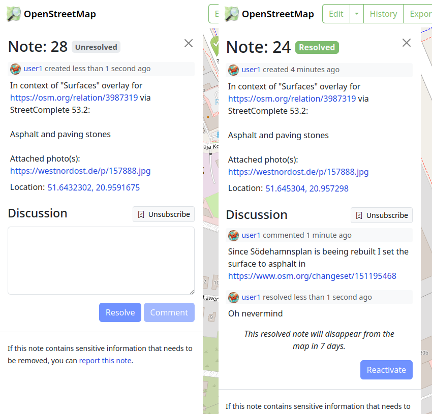
Notes UI Gets a Fresh Look

The most noticeable change this week is a refreshed user interface for notes. It’s now more in line with how changeset discussions look, making the whole platform feel smoother and easier to navigate. Future work will include a discussion pagination support.

And here’s how it looks for those who aren’t registered:

See full entry

At HOT, we are working on a collaboration with communities in informal settlements in Sierra Leone as part of the Know Your City project led by Slum Dwellers International.

The remote mapping of the settlements is hard, even with the excellent drone imagery flown by OpenStreetMap Sierra Leone. The environment is really dense, roofs overlap at different heights and structures that look like one from the sky actually include multiple buildings.

However, we have found the use of 3d and 2d imagery renders in parallel to be a bit of a game changer for this mapping activity. The mesh produced from the drone images allows us to angle and tilt in a way that we can better see how roofs interact with each other, what height they are and even sometimes how buildings are divided inside. We think this has vastly improved the accuracy of what we are able to do remotely.

3d mesh of Kolleh Town, Freetown, Sierra Leone

3d mesh of Kolleh Town, Freetown, Sierra Leone

See full entry

Location: Congo Town, Freetown, Western Area Urban, Western Area, Sierra Leone

Thank you to those who are currently mapping or have mapped Sweetwater Texas in these few days it means a lot to me I honestly thought no one was going to help me and I would be left alone to struggle but y’all have proved me wrong and I wanted to thank you all and a special thanks to Tex2002ans for doing a lot of the work keep up the good work man!

anyways if you’re interested in joining the help the link is here. osm.org/#map=14/32.4696/-100.4006