Users' Diaries

Recent diary entries

Posted by Thelone1986 on 2 June 2024 in French (Français).

J’ai quelques nouvelles vidéos en stock, c’est le moment pour un update donc 😁

Pour être honnête, le mois de mai avait commencé assez normalement avec rien de vraiment particulier comme “projet”. Mes trois premières vidéos sont d’ailleurs relativement classiques :

Ce mappeur OpenStreetMap retourne dans le Bois de la Neuville et ne peut cacher sa déception - Version live de ce changeset où je mets à jour un ancien chemin vicinal pour ainsi dire à l’abandon dans le Bois de la Neuville et râle sur l’état de ce dernier en gros

Ce vététiste intermittent vous emmène sur le Chemin de la Bidouille dans le Bois de la Neuville - Vidéo sur le terrain de la trace GPS que j’ai utilisé pour la précédente (c’est clair 😅?). Au moins, ça me permet de montrer les incohérences de la signalisation sur place et le délabrement de ce bois

Améliorons Seraing (sur OpenStreetMap) - Épisode 37 (Les jardins et sentiers cachés de la Chatqueue) - Version live de ce changeset où j’ajoute quelques petits sentiers et un lot de jardins familiaux dans le quartier de la Chatqueue

C’est ensuite que la fin du mois prend une autre tournure. Il y a une semaine, j’ai été faire un tour à Mons-lez-Liège pour trouver le tracé de l’ancien tram vicinal 723 dans son premier tronçon en site propre en partant de Jemeppe qui était en partie absent sur OSM. Ça n’a pas été évident parce qu’une bonne partie est à l’abandon et envahi par la végétation, mais on peut péniblement se frayer un chemin à travers les orties et ronces (j’ai une trace GPS qui le prouve 😏).

Bref, j’ai également remarqué lors de cette sortie une petite rue qui était indiquée comme highway=living_street (zone de rencontre) alors qu’elle ne l’est pas dans la réalité. C’est un problème sur lequel j’avais “travaillé” il y a bien un an d’ici à Boncelles où de nombreuses impasses étaient taguées ainsi alors qu’en réalité, une seule a les panneaux F12a et b adéquats d’une zone de rencontre. C’est comme ça que vient la vidéo suivante :

See full entry

Location: 50.596, 5.511
Posted by dcapillae on 2 June 2024 in Spanish (Español). Last updated on 6 June 2026.

Villa Cele-María, edificio protegido en Paseo de Sancha. Villa Cele-María, edificio protegido en Paseo de Sancha, vivienda unifamiliar de estilo neomudéjar de finales del siglo XIX, antigua residencia del ingeniero José María de Sancha. Fuente: trabajo propio (CC BY-SA 4.0) disponible en Wikimedia Commons.

Algunos edificios protegidos de Málaga están incluidos en la lista de patrimonio cultural de Andalucía del Instituto Andaluz del Patrimonio Histórico (IAPH). La villa Cele-María, por ejemplo, es uno de ellos.

Para evitar conflictos entre el mapeado de edificios protegidos de Málaga y el mapeado del patrimonio cultural andaluz, he adaptado la propuesta de etiquetado de edificios protegidos y documentado el uso de la clave «ref:iaph».

Mi interés principal en este momento se reduce solo mapear edificios protegidos de Málaga. No obstante, estoy aprovechando la ocasión para añadir la clave «ref:iaph» a aquellos edificios protegidos por el Ayuntamiento que aparezcan además en la guía digital del IAPH.

See full entry

Location: La Caleta, Centro, Málaga, Málaga-Costa del Sol, Málaga, Andalucía, 29061, España
Posted by IrdiIs on 2 June 2024 in English. Last updated on 3 June 2024.

I was surprised and happy to see that such remote villages are well mapped. This wikipedia article , although short, provides some context about the village.

Since Vukël was almost fully mapped, I just added a few buildings and then moved on to the nearby villages, adding buildings to those as well. I didn’t want to end the day with just a couple of buildings, so I roamed the map and chose a village named Abat (42.3106, 19.8115) and added some buildings there too. Here s also a very short article about Abat on Wikipedia.

“#100VillagesIn100Days, #Day2”

问题:

在中国,辅路经常出现在主要道路的两侧并和主要道路连接,OSM维基百科也有相应的提及,但没有说明辅路在十字路口应如何和主干道路连接 如图;image (位置:osm.org/#map=18/34.57204/119.15876

由图可见,车辆可以从辅路进入主干道路,因此在十字路口中应和主干道路连接,但连接方式,从哪里连接,百科没有提及。

其他编辑者的方案:

See full entry

Posted by IrdiIs on 1 June 2024 in English.

Shushicë, according to Wikipedia, has a population of around 8,000 people as of 2011, which are the latest public statistics provided by the government of Albania. This village is quite significant in terms of its size and population, making it more comparable to a small city rather than a typical village.

Mapping Shushicë was a challenging task due to its vast territory and the dispersed nature of its small houses. The scattered settlements across a large area added to the complexity, making it difficult to ensure comprehensive coverage. For future projects involving villages of this size, I am considering utilizing a tasking manager to streamline the mapping process and ensure thoroughness.

Additionally, I found a short Wikipedia article about the village that could benefit from further improvements and updates. You can find the article here. Enhancing this article with more detailed information about Shushicë’s history, culture, and demographics would be beneficial for anyone looking to learn more about this unique village, so i encourage you to also contribute to Wikipedia.

” #100VillagesIn100Days #Day1 “

Location: Byshek, Shushicë, Elbasan Municipality, Elbasan County, Central Albania, 3025, Albania

Hello Fellow Mappers, My name is Henny Vianelde de Jesus Pires, and I am from Timor-Leste. I have been using OSM since 2022 and am currently participating in the OMGuru Fellowship 2024. I am excited to share how I got involved with open-mapping, what I find fascinating about the fellowship, my experiences, what I have learned, and how it has impacted me.

Introduction

Participating in the OMGuru fellowship has been a significant journey of learning and growth. As part of the validation track, I immersed myself in the world of OpenStreetMap (OSM), using various online platforms to ensure the quality of mapped data. This entry outlines my experiences, lessons learned, and the impact of my work.

How I Got Involved with Open-Mapping

My journey with open-mapping began in 2022 when I first heard about OpenStreetMap. The collaborative and open nature of OSM intrigued me, and I quickly became passionate about contributing to this global map. The idea of creating detailed and accurate maps accessible to everyone, and after hearing about the OMGuru Fellowship, I was particularly excited and it motivated me to get involved and learn more about the different aspects of mapping.

Fascination with the Guru Fellowship

What fascinates me most about the OMGuru Fellowship is the opportunity to connect with like-minded individuals who are equally passionate about mapping and geospatial technology. The fellowship provides a unique platform for learning, collaboration, and growth. Additionally, the focus on ensuring data quality in OSM is particularly gratifying. Contributing to the accuracy and reliability of mapped data not only enhances the usability of OSM for various platforms but also builds trust among its users. By validating and improving data quality, I feel that I am making a significant contribution to the global mapping community and supporting projects that depend on precise and dependable geographic information.

Defining My Experience as a Guru

See full entry

Location: Dom Aleixo, Dili, East Timor

(Ελληνικό κέιμενο παρακάτω)

I’ve been dabbling with overpass today and wrote this query for correcting one of my biggest pet peeves in Greek name tags, the absence of stress accents. Since by the nature of the mistake it is often one out of thousands of street names and very subtle at a distance, it is quite hard to find manually, unless someone systematically added street names without stress accents on purpose in error. Maybe I should add these to the wiki page or make one for particularly Greek language examples. I excluded bus stops because in many Greek cities they are often written in all caps. I also exclude Σκρα and Κω, two single syllable words that are often names of streets in Greece. Neither caps nor single syllables are stressed.

Έπαιζα λίγο με το overpass σήμερα και έγραψα το παρακάτω query για τη διόρθωση ενός από τα μεγαλύτερα μου pet peeves στα ελληνικά tags για ονόματα, η απουσία τονισμού. Λόγω της φύσης του λάθους είναι συχνά ένα από χιλιάδες ονόματα οδών και αρκετά διακριτικό από μακριά, είναι αρκετά δύσκολο να βρεθεί με το χέρι, εκτός αν κάποιος συστηματικά βάζει ονόματα οδών χωρίς τόνους επίτηδες από λάθος του. Ίσως πρέπει να το προσθέσω στο wiki ή να κάνω σελίδα για ελληνικά παραδείγματα. Απέκλεισα τις στάσεις λεωφορείων γιατί σε πολλές πόλεις γράφονται με κεφαλαία. Απέκλεισα επίσης τις Σκρα και Κω ως κοινά μονοσύλλαβα.

// gather results nwr ["highway"] ["highway"!="bus_stop"] ["name"] ["name"!~"ά"]["name"!~"έ"]["name"!~"ί"]["name"!~"ή"]["name"!~"ώ"]["name"!~"ό"]["name"!~"ύ"] ["name"!~"Ά"]["name"!~"Έ"]["name"!~"Ί"]["name"!~"Ή"]["name"!~"Ώ"]["name"!~"Ό"]["name"!~"Ύ"] ["name"!~"ΐ"]["name"!~"ΰ"] ["name"!="Σκρα"]["name"!="Κω"] ({{bbox}}); // print results (._;>;); out meta;

Posted by IrdiIs on 1 June 2024 in English. Last updated on 16 August 2024.

Albania’s mapping, especially in rural areas, is lacking. Villages, in particular, are often not mapped at all. To address this, I’ve set myself a challenge: to map 100 villages in 100 days. I’ve used tools like Overpass Turbo and a Python script to select these villages randomly. Below, I’ve listed the villages, although I haven’t checked if they are already mapped. In the event that a village on the list has already been mapped, I will replace it with another. I’ll update regularly on my progress.

See full entry

Posted by Candid Dauth on 1 June 2024 in English.

I really missed Openptmap ever since the service stopped working a few years ago. It was an important feature of FacilMap that I had used frequently in my daily life. This is why I have decided to invest in a bigger server to be able to render and host the tiles myself.

I have set up a tile server with the original Openptmap styles on https://pt.facilmap.org/. You can browse the tiles through FacilMap.

For now, tiles are generated when first requested, so rendering the map will be very slow when a region is first accessed. Also, there are no automatic updates of the map yet, so for now the state of the map will be frozen in time. When I find the time, I want to bring the setup up to date to enable automatic updates. If you have the skills and want to contribute, what would be needed would be to rewrite the filter and style into an osm2pgsql flex output Lua script.

If you find this service useful, a financial contribution would be greatly appreciated.

依据辽宁省丹东市东港市政府公布的文件,对东港长安镇下辖的1社区6行政村以及部分村下有建制的小组(小村庄)进行补充,后续将对该镇及附近地区进行更具体的综合信息补充。也欢迎各位进行改进和批评。 图片:https://ibb.co/QXFk3B6

Location: 红石村, 长安镇, 东港市, 丹东市, 辽宁省, 中国

Welcome to the ninth OpenStreetMap NextGen development diary.

This week was focused on providing final touches to the core system. Within the few days I’ll publish details on how to get started contributing! Keep an eye for a dedicated diary entry 🙂/.

🔖 You can read my other development diaries here:
osm.org/user/NorthCrab/diary/

⭐ This project is open-source and publicly available:
https://github.com/Zaczero/openstreetmap-ng

🛈 This initiative is not affiliated with the OpenStreetMap Foundation.

Let’s jump into this week’s highlights.

macOS and ARM support

OpenStreetMap-NG development environment has received MacOS support. Meaning that it can now be developed on Linux, MacOS, and Windows through WSL2. The installation instructions are the same for all platforms and contain just a single step: install and run nix.

Changesets History Refresh

See full entry

Bułgaria jest krajem na południu Europy, graniczącym z obszarem Bałkanów i Azji Mniejszej (Turcji). Jest prawie 3-krotnie mniejsza terytorialnie od Polski, w ilości ludności - prawie 6-krotnie; w wielkości społeczności OpenStreetMap - prawie 10-krotnie mniejsza od społeczności poświęcającej swój czas na obszar Polski! To wszystko powoduje, że nawet w przypadku największych miast Bułgarii łatwo dostrzec “białe plamy”, które powinny być wypełnione budynkami, chodnikami, parkingami dla samochodów itd., nie mówiąc już o obszarach zagospodarowania przestrzennego jak lasy, pola uprawne, zbiorniki wodne itd.

Bułgaria to także - z racji Morza Czarnego i Gór Półwyspu Bałkańskiego, ciepłego klimatu śródziemnomorskiego, smacznej kuchni (słowiańsko-bałkańskiej, z wpływem kuchni tureckiej) i przystępnych cen (niższych niż w Polsce) - wspaniałe miejsce z uwagi na turystykę i wypoczynek (piszę to wszystko z doświadczenia własnego).

Niestety, dobrej jakości źródeł do mapowania Bułgarii nie ma - tu trzeba trzymać się trudno dostępnych danych kadastru (https://kais.cadastre.bg/) i zdjęć satelitarnych Esri. Ale oba one, w połączeniu z lokalną, bułgarską społecznością, która - dzięki narzędziom typu StreetComplete, Every Door czy edytora w OsmAnd - może “oddolnie” uzupełnić szczegóły nieznane nam sprzed biurka często setki czy tysiące kilometrów od Bułgarii - stanowi wystarczający zestaw do wsparcia OpenStreetMap w Bułgarii. Pomoc bułgarskiej społeczności odwzajemni się po stokroć podczas odwiedzania tego niedocenianego turystycznie państwa.

See full entry

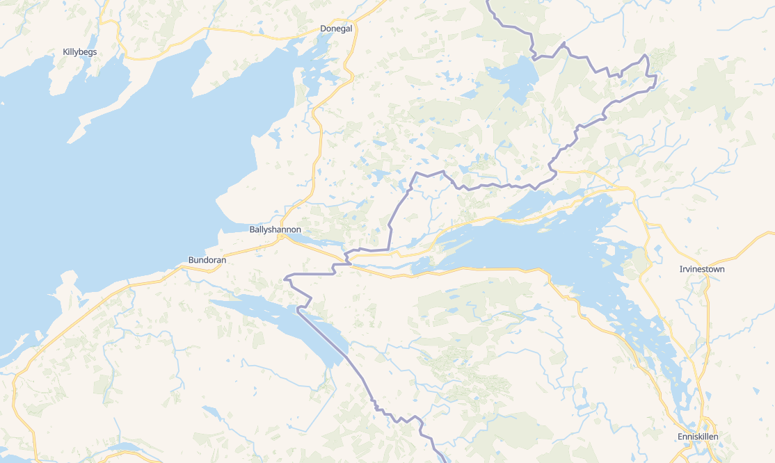
Esmu manījis, ka iekš OpenStreetMap Latvijas robežupes plūsma nereti sakrīt ar Latvijas robežu, bet… Kāpēc tā?!? Ja upe maina savu tecējumu, tad robeža NOTEIKTI NEMAINĀS.

Esmu veicis korekcijas ar Gaujas tecējumu un Latvijas-Igaunijas robežu, bet tagad nejauši pamanīju, ka kāds manu cītīgo darbu ir izdzēsis un atkal robeža sakrīt ar Gaujas tecējumu, tādā veidā nozogot Latvijas teritoriju.

Kā var atgriezt šo vandalismu?

Location: Tsirgumäe küla, Valga vald, Valga maakond, Igaunija

Le week-end dernier, comme annoncé, une carto party a eu lieu dans le Tarn & Garonne. Revenons sur le déroule dans ce billet.

Organisation

Sociale

Après avoir discuté avec le groupe toulousain des contributeurs d’OpenStreetMap. J’ai pris en main l’organisation d’une Carto Fête.

  1. Donc j’ai imposé le lieu, dans le Tarn & Garonne, comme j’ai assez bien argumenté sur le fait qu’il y ait peu de chance d’y avoir beaucoup de contributeurs. Que c’est une commune rurale, que ce n’est pas trop loin de Toulouse (et encore plus près de chez moi).
  2. La date, nous avons choisi mai, pour éviter la pluie et ensuite à l’aide d’un framadate, le jour - le choix étant entre le samedi et le dimanche.
  3. Ensuite, comme tout le reste, nous avons utilisé la liste de diffusion pour discuter.
  4. Quelques jours avant l’évènement, l’un des participants a proposé de créer un groupe sur Signal et personne n’a rien objecté.

Comme le début de l’organisation était assez public, nous avons été contactés par l’équipe “community” de tomtom. Ils voulaient nous aider pour cette cartofête. Nous n’avions rien à leur demander (ni pizza ni Gps et avons donc décliner l’offre d’aide).

technique

  • utilisation de la liste de diffusion
  • utilisation de Signal : avant, durant et après une fois les participants connus
  • StreetComplete le jour même, les téléphones portables pour la prise de notes, la prise de photos etc.

le déroulé

J’ai malheureusement été cloué au lit par de la fièvre et est dû me décommander à la dernière minute. Je suis encore énervé, embêter de ne pas avoir pu participer. Notre plan initial était de prendre Saint Antonin Noble val comme base et faire les villages alentours, mais il s’avère qu’il y avait assez de travail sur la ville même. Le résultat du travail ressemble à la copie d’écran ci-dessous.

See full entry

Location: Al Fond du Pont, Saint-Antonin-Noble-Val, Montauban, Tarn-et-Garonne, Occitanie, France métropolitaine, 82140, France

Tutorial sobre mapeamento de waterways com plugin FastDraw

Oficina sobre mapeamento de feições importantes para a redução de riscos de desastres (RRD) no OpenStreetMap

Desastre no Rio Grande do Sul (Brasil) - uMap para apoiar as ações de enfrentamento

Oficina sobre mapeamento de waterways no OpenStreetMap

Oficina sobre criação de web map com uMap e dados do OpenStreetMap

Palestra sobre criação de web map com uMap e dados do OpenStreetMap

Oficina sobre importação de pontos de interesse (POI) no OpenStreetMap

Mini curso para a Defesa Civil (Brasil)

Oficina sobre mapeamento de pontos de interesse (POI) com OpenStreetMap

Special interview about Brazilian NSDI on the first anniversary of YouthMappers UFRJ

Entrevista especial sobre a INDE no aniversário de 1 ano do YouthMappers UFRJ

YouthMappers UFRJ receives the Women’s Participation Award!

YouthMappers UFRJ recebe o Women’s Participation Award!

Our participation in the Open Data Day YouthMappers at UFBA 2024

Nossa participação no Open Data Day 2024 do YouthMappers at UFBA

Web map do mapeamento colaborativo para redução de riscos e desastes (RRD)

Web map of colaborative mapping for the Disaster Risk Reduction (DRR)

Mapear POI no OpenStreetMap e exibir dinamicamente com uMap

Mapping POI in OpenStreetMap and displaying dynamically with uMap

Resultados do GIS DAY 2023!

V Olimpíada Brasileira de Cartografia incluiu o OpenStreetMap como parte de sua etapa prática

V Brazilian Cartographic Olympiad included OpenStreetMap as part of its practical stage

Geocodificação com OpenStreetMap

Mapeamento humanitário e OpenStreetMap

Location: Recreio dos Bandeirantes, Rio de Janeiro, Região Sudeste, Brasil

Mapeamento de cursos d’água facilitado com o plugin FastDraw para JOSM

Dra. Raquel Dezidério Souto (IVIDES.org e YouthMappers UFRJ)

Este tutorial visa orientar a utilização do plugin FastDraw para Java OpenStreetMap Editor (JOSM), que facilita muito o desenho das feições e possibilita o traçado sinuoso, típico dos cursos d’água.

1- Instalar o JOSM https://josm.openstreetmap.de/

2 - Abrir o JOSM e instalar os plugins FastDraw e OpenData em Editar -> Preferências -> Plugins

3 - Realizar a autenticação na conta do OpenStreetMap (osm.org)

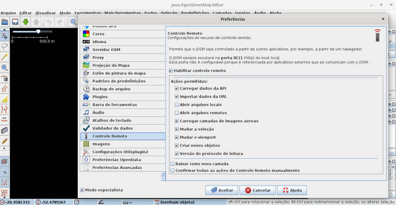
4 - Ainda com o JOSM aberto, em Editar -> Preferências, ativar a caixa de verificação “Modo especialista”, realizar a autenticação no OSM (item Servidor OSM) e ativar o Controle remoto. Clicar em Aceitar, para que as mudanças sejam efetuadas.

https://upload.wikimedia.org/wikipedia/commons/thumb/f/f2/Fig0_autenticacao_josm.png/800px-Fig0_autenticacao_josm.png?20240530024843

5 - Escolher uma tarefa a ser mapeada em https://tasks.hotosm.org/projects/16706, clicar em mostrar tarefas, clicar em um quadrado branco e em Colaborar. Informar seu nome de usuário e senha do OSM.

See full entry

Location: Centro Histórico, Porto Alegre, Região Geográfica Intermediária de Porto Alegre, Rio Grande do Sul, Região Sul, Brasil
Posted by SomeoneElse on 29 May 2024 in English. Last updated on 11 November 2024.

A simple "shortbread" / "VersaTiles Colorful" maplibre-gl vector map

Lots of people have written diary entries and there have been other announcements and demos. You might wonder why we need another?

The idea of this is to provide a “soup to nuts” guide in a similar style to the existing “Switch2osm” Serving Tiles guides for raster tile servers.

Introduction

There are two major pieces to this. The first piece creates a set of vector tiles that can be served by a web server. The second provides a way for clients to access that data - and clients also decide how to display it.

The code in this example is for web clients, but it’s also possible to create other sorts of clients too (for example, Android or iOS apps).

See full entry

Location: Larganhugh, Melvin Electoral Division, Manorhamilton Municipal District, County Leitrim, Connacht, Ireland
Posted by Zverik on 29 May 2024 in English.

I make Every Door to be the best on-the-ground surveying app. Its focus has always been shops and amenities, but it’s summer now! Ride a bike outside a city, take a scenic route. And bring Every Door with you, because it is ready for outdoor adventures.

Today version 5.1 has been published to both major app stores, and soon on the rest. Here’s what the app learned to do in May:

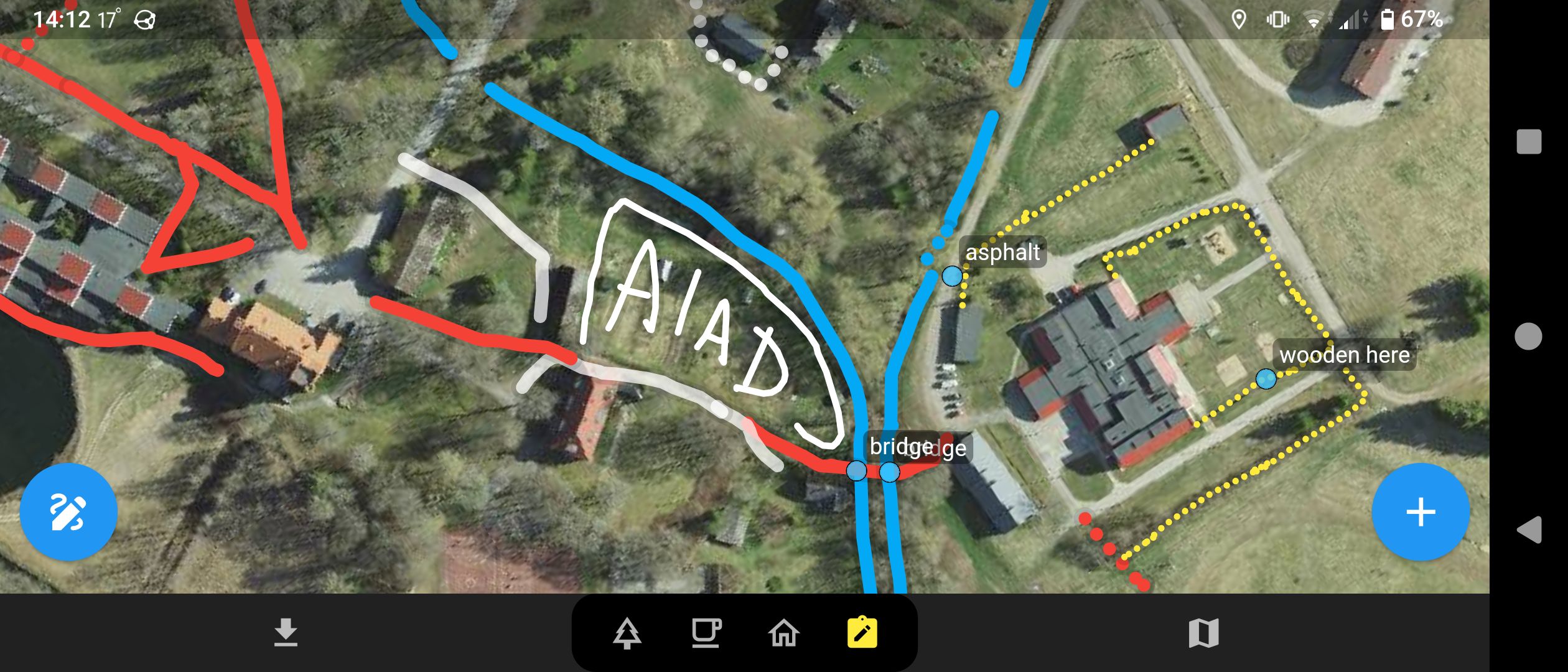
Every Door app with scribbles drawn on top of a satellite imagery

We have always had map notes, but now you can draw on the map! Saw an unmapped track road or a stream? Open the 4th mode in Every Door, unlock the scribble mode, choose the type and draw with your finger. This goes to a separate database, which you can then use in JOSM or Rapid.

Read this wiki page to learn how it works and how to add the layer to your editor.

See full entry

Two months later I’ve made my way deeper into a lot of OSM development of the last decade, learning changeset comments, OSM notes, catching up with recent tagging style and trends and using street imagery tools.

I tried to fix issues documented in OSM data as well as from the OSM notes map layer. After some quick wins I got challenged by tasks like merging dozens of tags and bus relations when merging split directions of Schandauer Straße in Pirna back to ‘ground truth’ - a 4/5-lane marked primary town highway. Destination tagging had been try-n-error before stepping into OSM community forum. That opened a wide pool of expertise and discussion supplementing the more authoritative wiki documentation, especially tools for reconstruction/QA of destination tags into visual form of road signs.

Tempted to photo-document rather than note down observations I joined Mapillary street imagery. It feels like a great tool for cheap document including sharing recent changes and situation in the field to fellow mappers. Despite of my rather basic equipment - mapillary app on mobile - I enjoyed looking at 360-degree-photograph-series of some very active contributors. These images look amazing and seem like the way to go.

Recently I made my first steps to preserving history in OpenHistoricalMap, the spin-off for information, that cannot and shouldn’t be preserved by current OSM life-cycle tagging. There is not much information in my area yet and a lot of discussion regarding rather basic mapping techniques. It feels like the pioneer days in OSM back in 2008.

More to come …