OpenStreetMap logo OpenStreetMap

Users' Diaries

Recent diary entries

Posted by The Core on 22 May 2024 in German (Deutsch).

Wir sind in Bewegung auf der Suche nach Orten wo wir Musik hören, tanzen, Internet nutzen, Panorama Sicht geniessen und Leute anziehen, die in Freiheit mit Anstand zu Mensch, Tier und Natur leben können und wollen.

Wir haben Regeln, zum Schutz unserer Gesundheit, der Umwelt, unseres Wohlbefindens. Wer ohne Regeln leben möchte ist bei uns am falschen Platz. (wie können hier Fotos hinzugefügt werden ?)

We are on the move, looking for places where we can listen to music, dance, use the internet, enjoy panoramic views and attract people who can and want to live in freedom with respect for people, animals and nature.

We have rules to protect our health, the environment and our well-being. Anyone who wants to live without rules is in the wrong place with us.

Estamos en movimiento buscando lugares donde podamos escuchar música, bailar, utilizar Internet, disfrutar de vistas panorámicas y atraer a personas que puedan y quieran vivir en libertad, respetando a las personas, los animales y la naturaleza.

Tenemos reglas para proteger nuestra salud, el medio ambiente y nuestro bienestar. Si quieres vivir sin reglas, has venido al lugar equivocado.

Location: Haza Almayata, Los Martínez, Viñuela, La Axarquía, Málaga, Andalusien, 29712, Spanien
Posted by NorthCrab on 22 May 2024 in English. Last updated on 23 May 2024.

Welcome to the eighth OpenStreetMap NextGen development diary.

This time the diary is one day early due to how much progress has been made.
There is more than enough for me to prepare a showcase 🏋.

🔖 You can read my other development diaries here:
osm.org/user/NorthCrab/diary/

⭐ This project is open-source and publicly available:
https://github.com/Zaczero/openstreetmap-ng

🛈 This initiative is not affiliated with the OpenStreetMap Foundation.

Notes UI Gets a Fresh Look

The most noticeable change this week is a refreshed user interface for notes. It’s now more in line with how changeset discussions look, making the whole platform feel smoother and easier to navigate. Future work will include a discussion pagination support.

And here’s how it looks for those who aren’t registered:

See full entry

At HOT, we are working on a collaboration with communities in informal settlements in Sierra Leone as part of the Know Your City project led by Slum Dwellers International.

The remote mapping of the settlements is hard, even with the excellent drone imagery flown by OpenStreetMap Sierra Leone. The environment is really dense, roofs overlap at different heights and structures that look like one from the sky actually include multiple buildings.

However, we have found the use of 3d and 2d imagery renders in parallel to be a bit of a game changer for this mapping activity. The mesh produced from the drone images allows us to angle and tilt in a way that we can better see how roofs interact with each other, what height they are and even sometimes how buildings are divided inside. We think this has vastly improved the accuracy of what we are able to do remotely.

3d mesh of Kolleh Town, Freetown, Sierra Leone

3d mesh of Kolleh Town, Freetown, Sierra Leone

See full entry

Location: Congo Town, Freetown, Western Area Urban, Western Area, Sierra Leone

Thank you to those who are currently mapping or have mapped Sweetwater Texas in these few days it means a lot to me I honestly thought no one was going to help me and I would be left alone to struggle but y’all have proved me wrong and I wanted to thank you all and a special thanks to Tex2002ans for doing a lot of the work keep up the good work man!

anyways if you’re interested in joining the help the link is here. osm.org/#map=14/32.4696/-100.4006

Posted by A35K on 20 May 2024 in English.

First time writing a diary, I have no idea how this is supposed to work

First off I´m gonna talk about the class:bicycle tag

This tag is used to describe how comfortable a certain way is for a cyclist (with class:bicycle=3 being great and …=-3 being really bad). The tag is mostly subjective and surveys are needed.

I first started using it when OSM based routers kept routing me over a secondary road where it is technically legal (?) to cycle on but rather dangerous due to heavy motor traffic combined with a speed limit of 80km/h. Since only GraphHopper seems to be using the class:bicycle tag for it´s routing it´s the only OSM router which has now stopped telling me to use that road. Great success!

Now fast forward a few weeks and I found out that this tag is extensively used in Munich to “improve” bicycle routing. I don´t fully agree with the way the people there implemeted it as now busy roads are tagged as “better” as seperate cycleways due to irrelevant things such as width.

But I don´t live in Munich so it´s not my problem, so I´d rather focus on implementing this tag in the city of Unterschleißheim. I´ve already done some progress and pretty much every road and path in Lohof-Süd is now equipped with this tag to improve routing, and it did work pretty well as Graph Hopper uses the safer roads even if the route will end up being a few meters longer. Great success again!

I want to implement this tag in other areas of Unterschleißheim but I am not really sure how to make sure that I´ve reviewed every road. I thought about creating a spreadsheet with every road name of the city but that would take a lot of time or good overpass-api skills (which I don´t have). I´ve decided that I would split the city into different sectors and add the class:bicycle tag for those sectors one by one.

About mapillary…

While this doesn´t fit to the rest of the diary I still want to include this as it would help implementing the tag.

See full entry

Location: Lohhof, Unterschleißheim, Landkreis München, Bavaria, 85716, Germany

The Bangladesh Open Innovation Lab (BOIL) and OpenStreetMap Bangladesh (OSMBD) are teaming up to host the “State of the Map Bangladesh (SotMBD) ‘2024” conference, a first of its kind in Bangladesh, a national gathering focused on mapping and geospatial technology. It aims to gather all significant stakeholders, including IM professionals, NGOs, government counterparts, industry leaders, academic experts, and geospatial enthusiasts from across the nation and the globe. This inaugural event aligns with the broader “State of the Map (SoTM)” event series facilitated by the OpenStreetMap Foundation and the global OpenStreetMap Community, reflecting a global effort to enhance open mapping initiatives. Additionally, SotMBD will be integrated into the Humanitarian OpenStreetMap Team’s (HOT) Opensummit program, emphasizing its role in fostering collaboration and sharing knowledge in the geospatial community.

Set against the breathtaking backdrop of Cox’s Bazar, the longest natural sandy sea beach in the world, the extraordinary event is set to unfold that promises to captivate and inspire. Scheduled for September 28th and 29th, 2024, this unique gathering aims to unite a diverse array of participants for a celebration of community and cooperation. The tranquil and scenic beach view will be an ideal location for an event aimed at promoting connections and creating enduring memories. Cox’s Bazar, known for its breathtaking views and lively local culture, not only serves as a location but also provides an engaging experience that enhances the atmosphere and appeal of the event. The organizers are carefully curating a program that will not only leverage the scenic beauty of the area but also underscore a commitment to inclusivity and engagement. Whether you are a local resident or a visitor from afar, this event promises an enriching experience that showcases the best of what Cox’s Bazar and Bangladesh have to offer.

See full entry

Location: Hotel Motel Zone, Cox's Bazar Sadar Upazila, Cox's Bazar District, Chattogram Division, 4758, Bangladesh

We participated in the OSPP hosted by the Chinese Academy of Sciences, which stands for Open Source Promotion Plan. It is held during the summer every year and encourages students of all grades to contribute to open source projects from July to September. This is very similar to GSoC.

Introduction

OpenStreetMap is a map project initiated in 2004 by Steve Coast of the UK, based on the principle of knowledge openness. Its data model enables mappers to represent and abstract complex real-world structures by utilizing three abstract elements types, for instance, public transportation. Since 2016, the OSM Community has submitted projects related to public transport to GSOC annually. The main work is focused on a JOSM plugin called PT Assistant.

Currently, the project we initiated aims to develop a cross-platform editor utilizing a modern front-end technology stack, which is easy to use with clear interactions.

Why do we need this project?

When editing public transportation relations using iD or JOSM, you may often spend a lot of time on tasks such as selecting each segment from the starting point to the endpoint. You might be surprised to find that even at an intersection where you want to turn, the continuous straight line has not been broken for your selection.

We hope to reduce such energy consumption thing for mapper when editing public transportation by automatically calculating possible bus routes through short-distance navigation after mappers specify the stations along the way. The mapper can then fine-tune it so that it conforms to the actual route taken by buses.

At the same time, we also hope to save time in certain situations, such as when creating a group of bus stops with identical names. There is no need for manual maintenance of multiple bus stop signs composed of relations; they will be automatically matched for you. Or when moving a station sign, parking spots are moved automatically.

See full entry

Hello OSM World,

This is the first post in the Worst of OSM in Ghana series. I start with improving landuse=residential in Kumasi.

About 3 years ago someone mapping for an institution decided to randomly map a ton of residential landuse areas across Ghana. Some local contributors had lengthy message exchanges with them before they stopped to map. Why? Because these landuse areas are either connected to some building or highway, etc… 
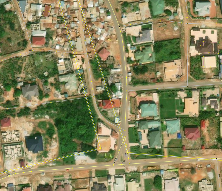
© OpenStreetMap Contributors. Screenshot from JOSM with Bing

Fast forward 2024, many of these ways still exist in OSM and interferes with new contributions. Kumasi was selected as the start of trying to reuse/delete/improve these landuse=residential because Sammyhawkrad have really put a lot of time into improving data coverage in Kumasi but these landuse=residential definitely throws him away.

In summary this is how I improved the data:

See full entry

Location: Alabar, Asokore-Mampong Municipal District, Ashanti Region, Ghana

sorry if my grammar sucks and all that I never had a good grasp on it in life. It’s been a few days since I started modeling Sweetwater so it can show up on Pokémon go when it updates their map though I’ve been aware that they might use specific versions but never hurts to model the town still, but the only issue is that no one in my town uses OSM anymore meaning I am completely alone.. a few days ago, I tried getting help which did work but not in the way I expected but hey better than nothing well all I wanted was help with buildings and all of that due to the town of Sweetwater Texas being hardly mapped (buildings wise). I tried requesting help though the notes, but it got resolved but the person gave me a website to help making it a bit faster but also giving me somewhat outdated building data.

if you’re interested in this whole thing and want to help out with the buildings or just update some information here’s the link to Sweetwater Texas

Recently while updating business information in my area, I noticed that outdated POIs would often include a defunct website. When attempting to follow the links in OSM, I was just presented with an error. That gave me the idea that I could proactively identify POIs that may need validated in person.

After some tinkering, I came up with a python script that will query OSM data for nodes with websites, then iterate over the websites to see which return errors when connecting. I started with logging these to a text file, but then realized that I could export them all to a kmz file and import them into Organic Maps. Now when I’m out and about I can launch Organic Maps to find areas that I should validate.

Screenshot of Organic Maps with pins through Amsterdam

When you select a pin, it’ll give you more details on the failure.

See full entry

Compléter l’étymologie des rues d’une commune

Sujet culturel et rigolo que de retrouver facilement ce que représente le nom d’une rue. Le tag name:etymology:wikidata permet de relier un objet OSM à Wikidata où l’on retrouve les données liées du Web de l’humanité :-).

Process:

  • Extraction des rues de la commune avec Overpass
  • De nombreuses moments pour faire la correspondance entre le nom de la rue et son objet Wikidata (recherche sur le web, dans des livres, aux archives communales et départementales) ;
  • Gestion du tout avec OpenRefine. Merci Wikitech pour la mise à disposition <3
  • Mise à jour du tag name:etymology:wikidata depuis le fichier constitué à l’aide du code Yapafo. Le commentaire du changeset est explicite et accompagné du hashtag “#TagNameEtymologyWikidata

Les données étymologies sont visualisables avec le super outil Open Etymology Map de Daniele Santini.

Mise à jour du taux de complétion des adresses dans OpenStreetMap. Cet article fait suite à 2 autres ici en mai 2023 et là en septembre 2022, où je compare le nombre d’adresses par communes en Wallonie entre la source de référence des adresses (ICAR) et OSM.

En Wallonie, 1,196,551 adresses sont répertoriés dans OSM, contre 1,634,840 dans ICAR (73.2 %). On était à 64.4 % en septembre 2022 et 67.1% en mai 2023.

Voici une carte choroplète, montrant, pour chaque commune, le degré de complétion des adresses dans OSM par rapport à ICAR. Les limites de provinces sont soulignées par un trait plus gras.

carte complétion adresses mai 24

Et une carte de l’évolution des adresses depuis mai 2023.

See full entry

Location: Au Pigeon, Marbehan, Rulles, Habay, Virton, Luxembourg, Wallonie, 6724, Belgique

Example of different map styles

Let’s imagine that you’re a pizza delivery company, and you’ve got an app that shows where you are, where your customers are and where a delivery person is between the two. Obviously you need some sort of map that shows the three in context. You can’t use Google Maps for cost or other reasons, and whatever framework your using will accept raster tiles in the almost universal format https://server/Z/X/Y.png, so why not use OpenStreetMap’s standard layer? After all, it’s free!

Well:

See full entry

Location: Pizza, Uvu Uda, Askira-Uba, Borno State, Nigeria

Amazing Experience ……..

The open street map foundation is an international not - for - profit organization supporting, but not controlling. the OSM project. it is dedicated to encouraging the growth, development and distribution of free geospatial data and to proving geospatial data for anyone to use and share. The OSMF had quite recently Started a worldwide membership campaign with the objective of growing and diversifying OSMF membership in regions where there are very low or no OSMF members.

I am proud to say that I was part of this campaign. On the first few virtual meetups via Google meet, I had promptly signed up for the campaign Ambassadors role as I believed I could use whatever little ideas and experiences. I have learnt a lot about community.

thank you for the wonderful opportunity.

Providing updates! The OSM Wiki of the OSMF Membership Drive Campaign 2024 Plan is in the wiki: osm.wiki/OSMF_Membership_Drive_2024

We will also provide updates and have a space for feedback in the Community Forum using this thread: https://community.openstreetmap.org/t/updates-osmf-membership-drive-campaign-2024/109280

Welcome to the seventh OpenStreetMap NextGen development diary.

This week, I focused on delivering core website functionalities and website and migration script optimizations 🚤.

🔖 You can read my other development diaries here:
osm.org/user/NorthCrab/diary/

📖 This project is open-source and publicly available:
https://github.com/Zaczero/openstreetmap-ng

🛈 This initiative is not affiliated with the OpenStreetMap Foundation.

In Case You Missed It…

OpenStreetMap-NG is planned to have its first development release at the end of this month, May. After this milestone, the project will be open for new contributors! My current work focuses on delivering on that promise, finishing the core functionalities, and stabilizing the code.

Originally posted in diary #5.5.

New Fast Rendering Engine

One of the highlights of OpenStreetMap-NG is its brand new, super fast object rendering engine. It’s a significant improvement over the current solution.

For example, rendering all of Poland (about 1500 ways) takes a mere 34ms.

See full entry

本文是中华人民共和国相关部门的法规政策,仅供读者参考。

来源:https://gi.mnr.gov.cn/202405/t20240511_2844891.html https://www.gov.cn/zhengce/zhengceku/202405/content_6950568.htm

自然资源部办公厅 工业和信息化部办公厅

关于规范移动互联网应用程序中登载使用地图行为的通知

自然资办函〔2024〕972号

各省、自治区、直辖市自然资源主管部门、电信主管部门,移动互联网应用程序主办者:

近年来,地图以其立体直观、耦合作用显著等特点,不断应用到移动互联网应用程序(以下简称APP)中,在推动经济社会高质量发展、服务百姓生活等方面作用日益凸显。为规范APP登载使用地图行为,进一步提升APP的直观性、交互性、动态性,现将有关事项通知如下:

一、提高政治站位

正确的国家版图是国家主权和领土完整的象征,体现了国家在主权方面的意志和在国际社会中的政治、外交立场。地图是国家版图最常见、最直观的表现形式,具有严肃的政治性、严密的科学性、严格的法定性。APP中登载使用未依法履行地图审核程序的“问题地图”,错绘我国国界线、漏绘我国重要岛屿,甚至标注涉军涉密敏感信息,将严重损害我国国家主权、安全和发展利益。各地、各有关单位、各移动互联网应用程序主办者要坚持总体国家安全观,充分认识正确登载使用地图的重要性,增强国家版图意识,坚决防止“问题地图”的产生。

二、规范相关行为

(一)依法履行行政审批。从事互联网地图服务的APP主办者应按照《中华人民共和国测绘法》《中华人民共和国反电信网络诈骗法》《互联网信息服务管理办法》《地图管理条例》等规定,向自然资源主管部门、电信主管部门履行地图审核程序、ICP备案手续。地图内容发生变化或者进行更新的,应依法重新履行地图审核程序。

(二)严格落实主体责任。APP主办者应落实安全主体责任,确保在登载使用地图时准确反映中国领土范围、行政区域界线、重要岛屿等并标示审图号;引用地图时要注明地图来源和审图号;对违反法律法规登载使用地图的注册用户要依法依约采取警示、限制功能、关闭账号、保存记录并上报等处置措施。从事互联网地图服务的APP主办者,还应持续强化技术能力建设,加强对互联网地图新增内容的核查校对。

(三)强化国家版图意识宣传。APP主办者应按照自然资源主管部门、电信主管部门要求,积极参与国家版图意识宣传工作,知悉了解地图管理相关法律法规,牢固树立“地图无小事”的观念,在APP开发、上线审查阶段明确规范使用地图的要求,从源头上防止“问题地图”的出现,以实际行动维护国家主权、安全。

三、增强协同联动

(一)优化服务。各地自然资源主管部门、电信主管部门要优化地图审核、APP备案政务服务,提供信息化服务等便利措施,提高工作效率。各地自然资源主管部门要加大标准地图投放力度,继续通过标准地图服务系统bzdt.ch.mnr.gov.cn以及国家地理信息公共服务平台“天地图”bzdt.ch.mnr.gov.cn向社会公众免费提供标准地图和具有审图号的地图,不断满足社会公众、法人主体对地图的需求。

(二)建立机制。各地自然资源主管部门、电信主管部门应建立信息共享、应急处理、联合惩戒等工作机制,形成工作合力。两部门定期通报有关地图审核信息及APP备案信息,对梳理发现的APP中的“问题地图”线索进行会商,对重点违规线索开展深入调查,对可能出现的问题进行预判,对趋势性问题提出措施,提高防范“问题地图”和抵御风险的能力,督促APP主办者落实安全管理责任义务。

(三)加强监管。针对登载使用地图的APP存在“应当送审而未送审的,使用未经依法审核批准的地图提供服务的,或者未对互联网地图新增内容进行核查校对的,通过互联网上传标注了含有按照国家有关规定在地图上不得表示的内容的,未在地图的适当位置显著标注审图号的”等违法违规行为,自然资源主管部门将会同电信主管部门对APP主办者依法采取处置措施,营造规范健康的互联网地图服务市场环境。

自然资源部办公厅 工业和信息化部办公厅

2024年4月24日

In March 2023, I conducted a survey on women’s participation in OSM activities. It became apparent that individuals’ perspectives came into place and interpreted the survey topic differently. The survey aimed to gather perceptions, opinions, and insights into why some women do not participate in OSM activities and what factors may discourage those who were already participating from continuing. There were various reactions about the survey, from questioning the relevance of the topic to commending the effort to address it.

I was fortunate to have had support from various individuals for the topic, including Heather Leson, Arnalie Vicario, Pete Masters, Geoffrey Kateregga, and the Geochicas family, who were interested and open to exploring the topic through webinars and discussions. One such webinar featured speakers from diverse backgrounds:

  • Stellamaris Wavamunno Nakacwa, Programme Director at Youthmappers EverywhereSheMaps
  • Mikko Tamura, Community Manager at Open Mapping Hub Asia Pacific
  • Jaqueline Amorim, Expert Mapper in Geostatical Data/HOT Data Quality Intern in 2022

The webinar was moderated by Dr. Prince Kwame Odame from Africa, a lecturer at the University of Education Winneba-Ghana. You can review the webinar here.

A unique aspect of the survey was that, in addition to focusing on individuals who identify as women, I also sought perspectives from men. I was pleasantly surprised by some of their positive viewpoints, although there were also negative responses. I am grateful to everyone who took the time to participate in the survey.

One key takeaway from the survey is the importance of considering diverse perspectives. Just because something may not be perceived as an issue by one person does not mean it isn’t significant to others. We all view the world through different lenses, and it’s essential to be considerate and open-minded to learn from various angles.

See full entry

Posted by FFWHol_Norimaki on 14 May 2024 in German (Deutsch). Last updated on 1 January 2026.

Zusammenfassung

Hydrantenplanerstellung Freiwillige Feuerwehr Holenbrunn. Ziel war eine lauffähige lokale Lösung um:

  • einen “eigenen” Hydrantenplan zu erstellen (Papierplan ausdrucken/ Plan für Hydrantenschau).
  • anderen Wehren die Möglichkeiten aufzuzeigen und die Vorgehensweise weiterzugeben (diese Doku).

Netter Zusatzeffekt

  • Für außerhalb des Ortsgebietes einen Hydrantenplan zu haben um sich grob orientieren zu können (keine “Einsatzlösung”)
  • Für im Ortsbereich “fremden” Wehren das Finden des “besten” Hydranten zu erleichtern … z.B. wenn das Auto mal zu Wartung ist (so OSM verwendet wird, keine “Einsatzlösung”).

Ziel

  • Aufnehmen der Hydranten (Löschwasserstellen& -tanks)
  • Erstellen von Lageplan für Hydrantenschau
  • Ausreichende Genauigkeit für Nutzung
  • Hydranten per Handy-App auffindbar machen
  • Niederschwelliger Zugang für viele Teilnehmer
  • Niederschwellige Wartbarkeit durch viele Teilnehmer
  • Möglichst kostenneutral (Verwendung von Open Source)
  • Kein(e) Wartungsaufwand / -kosten für IT-Infrastruktur (“Server” bei OSM, “Clients” auf privaten Mobilgeräten aka Handy)

Out of Scope

See full entry