Users' Diaries

Recent diary entries

Posted by DeLouredo on 29 October 2023 in Galician (Galego).

A Canliña. Unha zona pequena e alta situada entre A Tella e O Coutiño, cunha casa grande como referencia, lindante con terreos de escasa lonxitude e dispostos en sucalcos, con muros realizados en pedra e escaleiras integradas neles.

Ei van unhas liñas de José R. Veiga Formigo, que alí vivíu:

“Mis recuerdos son de la infancia y adolescencia. Era la casa de mis abuelos maternos y de las reuniones familiares inolvidables. Su situación es antes de llegar a Fonte da tella, a mano izquierda en un alto. Desde su balcón yo me sentaba a leer las aventuras del Capitán Trueno, y más adelante, y con otra edad, Los Gozos y las Sombras etc..”
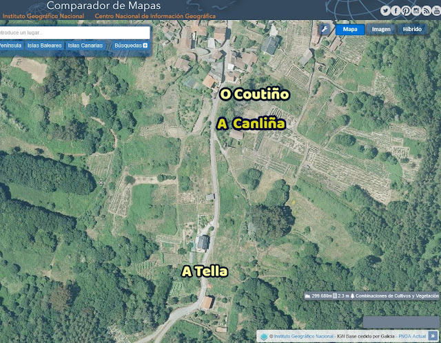
Mapa da zona A Canliña

Location: Casa Grande da Canliña, Louredo, Cortegada, O Ribeiro, Ourense, Galicia, 32200, España
Posted by N@Mabuza on 28 October 2023 in English.

This diary is a collaboration between Ibrahim and Nombuso.

As part of the open humanitarian mapping community working group mentorship programme, all mentees were asked to produce a legacy project. As Nombuso wanted to work on data that would benefit women and girls in Eswatini and Ibrahim wanted to improve his technical skills, we decided to collaborate on one joint project.

Choosing eSwatini health data as the focus of our project.

We know that good quality health data is an asset for women and girls (to be able to find where there are services, when facilities are open and how far they might be away). So we decided to investigate how well OpenStreetMap provided information on these services for map users. First, we tried to download and consolidate all of the health data in OSM (amenity=hospital, clinic and doctors).

Map of Eswatini

See full entry

This diary is a collaboration between Ibrahim and Nombuso.

As part of the open humanitarian mapping community working group mentorship programme, all mentees were asked to produce a legacy project. As Nombuso wanted to work on data that would benefit women and girls in Eswatini and Ibrahim wanted to improve his technical skills, we decided to collaborate on one joint project.

Choosing eSwatini health data as the focus of our project.

We know that good quality health data is an asset for women and girls (to be able to find where there are services, when facilities are open and how far they might be away). So we decided to investigate how well OpenStreetMap provided information on these services for map users. First, we tried to download and consolidate all of the health data in OSM (amenity=hospital, clinic and doctors).

Map of Eswatini

See full entry

Open Geospatial Data for Disaster Recovery/Response

Fiji is a small island developing state and has been and continues to be severely affected by the obvious impacts of climate change, i.e. increase in sea level causing coastal erosion, water shortages due to salt water intrusion and the more apparent impact of the increased occurrence of extreme weather events such as tropical cyclones, storms, floods, droughts etc. Having personally experienced some of the worst tropical cyclones that has ever made landfall in Fiji, the project has been developed in light of the after effects of these extreme events. It takes time, resources and finance to begin rebuilding after a tropical cyclone hits and many are ill-prepared for this recovery process. For years, many Fijian communities have been all too aware of and much too dependent on the disaster relief packages they receive post disaster occurrence from the Fijian government, FRCS, NGOs and even international aids. However, it should be made known that there are alternative forms of assistance available for individuals, businesses etc. in regards to disaster relief/rehabilitation packages. The aim of this legacy project was to map and update points of interests entailing locations and relevant information relating to financial institutions/bodies that offer or have in the past offered disaster recovery/relief packages to members of Fijian communities within the Northern and Central divisions.

Area of study

Text

Data Collection

A survey was undertaken to gauge respondents various level of awareness of current, available disaster recovery/response packages in Fiji. In addition, certain financial institutions were also contacted via face to face office visits and through email. The financial institutions targeted are as follows; (i) Sugar Cane Grower’s Fund (ii) Tower Insurance (iii) Fiji National Provident Fund (iv) Home Finance Company Ltd

Results

See full entry

Palestra no Latinoware 2023

Tive grande satisfação em ministrar palestra sobre Geocodificação com OpenStreetMap no XX Congresso Latino-americano de Software Livre e Tecnologias Abertas - Latinoware, no dia 18 de outubro de 2023. O evento é promovido há 20 anos pela Itaipu Binacional e pelo Parque Tecnológico de Itaipu -PTI (Foz do Iguaçu, Paraná, Brasil).

img1

Três estratégias para geocodificar com Nominatim/OSM

Na palestra, apresentei os aspectos relacionados à geocodificação com dados do OpenStreetMap e três estratégias que podem ser utilizadas para esse fim:

  1. Script Python com biblioteca Geopandas + Nominatim
  2. PostgreSQL (com PostGIS), pgAdmin4 + Nominatim
  3. QGIS e Plugin MMQGIS

See full entry

Location: -22,857, -43,234
Posted by Davidien on 26 October 2023 in English. Last updated on 29 October 2023.

I made it an obligation to participate in this years edition of the SOTM Nigeria. I must say, it was worth it; because the various topics presented during this year’s conference opened up my mind to new possibilities in the world of GIS. I am also immensely grateful to the sponsors of this event for affording me the opportunity to be awarded a travel grant. Thank you SOTM Nigeria, see you in Lagos in 2024!

Location: Kuje, Federal Capital Territory, 903101, Nigeria
Posted by Ghostwalking on 25 October 2023 in English. Last updated on 26 October 2023.

Over the last few months, I’ve been filling out the houses and buildings in southwest London because I’m bored and have taken a strange fixation on improving the map in this way.

I have noted a few things over the last few months, particularly how the addresses to flats and rows of townhouses are managed. when marking out an area for a building of flats it only lets me put one address in, when flats typically have multiple addresses attached to the same physical building.

Not a major drawback at the moment but this is the main reason im not filling addresses in as there are typicaly more than one address attached to each building. Im not a coder here but this is my mild wednesday musing put on paper.

Posted by 38446 on 24 October 2023 in English.

Two years ago I somewhat naively asked on the wiki whether ÖPNVKarte couldn’t perhaps render the interval key somehow. I don’t think it would have to be as nicely designed as Transportparadise’s Oxford Bus Map, which even separates bus routes that share the same way. In my opinion, it would be sufficient to have the different patterns per way travelled (i.e. if two or more lines share the same way the pattern for the most frequent interval could be shown, or, more ambitiously, the intervals added up) for the map to give an overview of where public transport can take you more or less reliably. Unfortunately, I have lacked knowledge, experience and patience to use Maperitive and/or Overpass to try out how this could be put into practice and soon forgot about it.

The reason I came to think of this again was a holiday in Colmar, Alsace, France. To an outsider, the intervals of the city buses there are completely nuts, see for example this timetable pdf. But generalizing “37-48-41-51-44-etc.” into interval=45 would seem acceptable to me and a less fundamental question than how to discriminate between workdays and weekend. I am reflecting on this from a rural setting, where there might be no buses at all on Sundays.

Anyway, to a tourist, Colmar’s and Alsace’s public transport system is grand, amply subsidized and only partly affected by the typical downward spiral.

For our first hiking tour, we started from Wettolsheim Marbach through the vineyards first to the Les Trois Chateaux ruins and then on to the reconstructed Hohlandsbourg before heading back to the bus at Wintzenheim. The bus to Wettolsheim in the morning was in fact an on-demand service, a taxi ordered via the Flexitrace app and included in the normal fare: 1.50€ for a single trip, 11€ for 10 rides or 7€ for unlimited travel in 72 hours within Colmar and suburbs.

See full entry

Location: Colmar, Colmar-Ribeauvillé, Haut-Rhin, European Collectivity of Alsace, Grand Est, Metropolitan France, 68000, France

Reflecting on my experience at the SOTM Nigeria 2023 conference in Abuja, I can only describe it as an extraordinary blend of education and inspiration. The paper presentations were nothing short of eye-opening, shedding light on various facets of mapping, including cartography and geography. What made this experience truly enriching was the opportunity to interact and obtain ideas with distinguished professors, seasoned cartographers, accomplished geographers, and fellow mapping enthusiasts. Moreover, I had the privilege of contributing to the conference’s success by joining the volunteer team. I extend my heartfelt gratitude to Dr. Victor Sunday the coordinator of Unique Mappers for his organizing and chairing the conference, I sincerely appreciate the organizers, partners, sponsors, both for the conference in creating an amazing and enlightening event, and for the grant, as I await the promised refund to the entire volunteer team who came from Enugu State to Abuja for the conference, Obasanjo Space Centre, Municipal Area Council, Federal Capital Territory, Nigeria. #SotM2023 #HOTopensummit #TomTom #UMT #LionMappers #AfriGist #NASRDA #SciStarter #WNHub #MiyaAcademy #OSM #OSMNigeria

Posted by b-unicycling on 23 October 2023 in English.

Some time ago, I started adding links to 3D models on Sketchfab to ogham stones, sheela-na-gigs and high crosses in Ireland. I thought that this was a good idea to add value to the map, because we already link 2D images, 3D is just so much cooler and more useful. Some of these artefacts are not accessible to the public at all times, and having a digital 3D model makes them accessible for all the world (with a fast enough internet connection). Of course, you could just browse Sketchfab, but having the geolocation can be interesting and useful too.

Sometimes, museums or universities have contracted someone to make 3D models of artefacts that might be in storage in a museum or inaccessible in a farmyard, thus providing OpenAccess to these models in digital form.

What started this initiative of was that I found a working photogrammetry app called Kiri Engine. Full disclosure now: They have made me an ambassador for their app, since I’ve been promoting it in a video already and have recommended it to a few friends in archaeology. But I would still promote it, even if they hadn’t done that.

I’ve made a video on how to use it (YouTube) which will be followed by another one soon. The previous video was about why and how to link to Sketchfab from OSM: YouTube. I had made a wiki page for Sketchfab, but it has experienced some editing since. For it to be useful, the link has to work as a link, so for now, we cannot use just an identifier for the model, but have to use a full link. Sketchfab does hoewever provide a short link which consists of https://skfb.ly/ followed by a (for now) 5-digit code of letters and numbers. This might be possible to utilize as an identifier. But for now, I’m using and would recommend using url:sketchfab with the short url.

See full entry

Die Graphenintegrations-Plattform (GIP) ist der zentrale, österreichweite Verkehrsgraph für alle Verkehrsformen inkl. Schiffe, U-Bahnen, Seilbahnen, Busse, KFZ, Radfahrer, Fußgänger etc.

Eine der markantesten Anwendung ist die intermodale Verkehrsauskunft für ÖV, MIV, Rad und Fußverkehr. Z.B. können Fußgänger die letzten Meter zwischen Haltestelle und Ziel durch Parkwege, Durchgänge etc. geroutet werden.

Diese amtlichen Daten werden in regelmäßigen Intervallen aktualisiert und unter CC-BY-4.0 allen Interessenten zur Verfügung gestellt. Die Quelldaten bleiben dabei im Besitz der Eigner (z.B. ASFINAG, ÖBB, Bundesländer …), es findet nur ein Abgleich der relevanten Daten statt.

Naturgemäß sind die höherrangingen Verkehrsdaten bevorzugt und inzwischen auch vollständig erfasst. Bei den Radrouten beginnt es sich auszudünnen, zur Zeit sind zumindest die Landesradwege österreichweit erfasst und als OGD verfügbar. Die Radrouten der Tourismusverbänden fehlen noch überwiegend.

Völlig blank ist die GIP bei den Wanderwegen. Mich wundert das nicht, denn Wanderwege sind eigentlich keine Verkehrswege sondern eher Wege für Freizeit und Sport. Im Gegensatz zu den Seilbahnen ist auch die unmittelbare wirtschaftliche Bedeutung gering.

Interesseneigner Wanderwege

Amtliche Daten zu den Wanderwegen könnte die Finanzierungskette Land - Tourismusverbände - Wanderwegeersteller (meist Gemeinden) transparenter und nachhaltiger gestalten. Sicher ein Vorteil für die Länder, weniger für die Tourismusverbänden, die den Freiraum gerne nutzen.

Möglicherweise ist auch das Militär daran interessiert. Die eigenen Ressourcen im Institut für Militärisches Geowesen (IMG) reichen für die eigenständige Datenerhebung nicht aus. Die historisch lang zurückreichende Unterstützung durch die Bundesamt für Eich- und Vermessungswesen (BEV) ist 2011 durch Einstellung der Österreichischen Militärkarte weitgehend weggefallen.

See full entry

Location: Innenstadt, Innsbruck, Tirol, Österreich