 OpenStreetMap
Users' Diaries
Recent diary entries

While I was mapping house numbers and other things in Ballyragget today, I noticed something curious: Buildings with “Step” or “Steps” in their name. There is a “Step House” in Ballyragget (check on OSM), probably called thus, because it has 5 steps leading up to the front door (a common feature in Georgian buildings). To my knowledge, there are only one or two more houses like that in Ballyragget, so having steps outside your front door must have seemed remarkable enough for people to give it that name.
 A.-K. D., CC BY-SA 4.0, via Wikimedia Commons
Then two other cases came to mind: the Steppes Bar in Callan (check on OSM) which seems to be named after the steps to the left of the entrance. Weird plural, but maybe it’s from ye olde times.
.jpg)
sdfds

摩崖石刻
historic=epigraph 似可,但目前使用较少
窑洞
可能 man_made=cellar_entrance 较好?
最高峰另有命名的山
natural=massif 据其wiki页可用于此用途,然而用者寥寥,且不允许为点状。
绿化带
landuse=village_green 、landuse=grass 不允许线状。
停船处
mooring=* 和 man_made=quay 不允许点状,leisure=marina \ amenity=ferry_terminal 允许为点状但前者是用来表示整个码头的(而不是泊位那块岸边)、后者专用于渡船上下客处。
宽阔的阶梯
似乎可以用 area:highway=steps ?
政府部门的院落
只有 amenity=townhall 、 office=* 不加别的标签就会渲染成点。 landuse=commercial 直觉上就不对;字面上比较符合的 landuse=institutional 、 landuse=governmental 、 landuse=civic_admin ,用的人都少,前二者在wiki分别标为“有争议”,“放弃”,第三者倒是“使用中”但不在 landuse=* 页的列表里,且都不渲染。
驾校考场
Невельск
Анива

I’m doing really, really detailed reed beds in Etulia Nouă, Moldova.
Moldova and it’s state
Moldova is not very detailed. In fact, most natural features aren’t even mapped. There are only roads, rough shapes of towns and town nodes. I’m currently creating lots of detailed reed beds and natural features there, especially near Lake Cahul.
Start detailing!
 I invite everyone to start detailing the undermined country of Moldova. It’s really beautiful! I’m detailing areas around Etulia Nouă, but you can pick any area you want, like Bălți, Giurgiulești, Comrat.
I enjoy reading people’s diary entries, so I’m starting my own. My current project is mapping public bookcases (PBs) in neighborhoods near me.
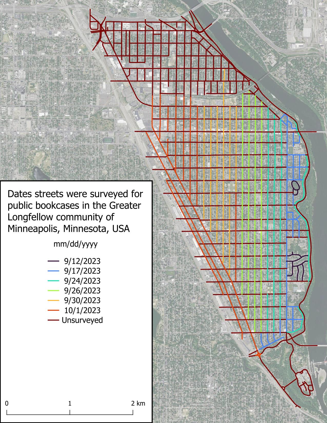
I started this project because I chance upon PBs when going for walks and can never remember where a PB is when I need one. There’s a map of Little Free Libraries (LFLs), but adding PBs to this map is “pay to play” which I don’t like, in addition to not displaying unaffiliated PBs. Other secondary goals include:
It seems I have developed a reputation in Ireland and the UK about my history mapping, because SK53 had tagged me in a toot about Martello towers. At first, I somewhat brushed it off, but as he probably knew, my interest was eventually triggered and I looked into the matter.
I remember that DeBigC was the first to tell me about Martello towers, but I can’t remember if he used a specific example or just shared his interest.
For those who aren’t familiar: Martello towers were built by the British Empire at a time when they were still ruling the waves, especially around the time of the Napoleonic Wars, when there was a threat of a Napoleonic invasion into British territory. They continued building them in port towns, so mostly along the coast, but not all of them are coastal. Apparently (according to Wikipedia), they are usually round and built in two levels with the guards living in it (i.e. building). They placed a cannon on the top which had a 360° reach, although one hopes that they only pointed it seawards.
The good news was that a lot of them were already mapped on OpenStreetMap, mostly with name=Martello Tower. The bad news (as pointed out in the toot) was that there was no consistent tagging scheme. Most of them were mapped as man_made=tower, and some had some sort of historic tag on them (ruins/ castle/ yes etc), but few were mapped as buildings. So, I came up with historic=martello_tower, skipping the proposal process and documented the tagging scheme in the wiki.
مركز وامارة
In this post, I’ll try to give some insights into the more recent work and workflows of the global State of the Map (SotM) program committee. After having been a member of the SotM program committee for the last couple of years, I figured this might be useful or at least interesting for other program committees or content teams.
Please note that the views and experiences expressed in this post are my own and that they are mostly based on my memory. I’m also trying to just describe how we worked, which may not be the best way, maybe not even a recommendable one, but one that seemed to work for us. Just because it worked for us doesn’t mean it will work for others though, and vice versa.
In some way, this post is also a follow-up to a previous post of mine where I wrote about the software and services behind the State of the Map. I’ll try to avoid duplicating content, so see the previous post for more information about the tools and services that were used.
Organisation
As long as I’ve been on the program committee, it was always organised such that it was mostly split into a ‘core program committee’ (I’ll refer to it as ‘core team’ in the rest of this post) and the full program committee (I’ll refer to it as ‘program committee’ in the remainder of this post), which included all members including the core team. I don’t remember if this split was a conscious decision, if it just emerged based on asking the program committee members about who wanted to help with which tasks, or if there was another reason. But at least so far, we haven’t had a reason to change this.
Program Committee
The primary tasks of the program committee were reviewing and rating the submissions of the talks, workshops, etc. and providing feedback on e.g. the draft for the call for participation before it got published. Once the call for participation was published, the program committee members were also encouraged to announce it in their local communities.
Core Team

Mapping a large urban area in its entirety is quite a rare task.
Pyongyang, the city I mapped, is an urban area 15km wide by 12km long. It took me over a year from April 2022 to May 2023 to complete, particularly the buildings and roads. But I’m really pleased with the result: just look at the state of the map!
Mapping a capital in its entirety is rare, and for several reasons:
-
Firstly, because all the major urban areas in the West have already been mapped. This leaves the countries with the fewest contributors, whose capitals may already have POIs… but rarely all the buildings and roads.
-
Secondly, because you need a good amount of motivation, when you’ve reached the 60,000th building and you’re still halfway there… well… you have to hang in there! I also think it’s hard to imagine embarking on such a lengthy mapping project. Imagine if you wanted to undertake a project like this for Hanoi… unfortunately it can be discouraging from the outset.
But mapping by small parts, by neighbourhood, is a method that worked quite well for me, so maybe it will work for others!
In short, there are still many capitals to be mapped on these basic themes! But getting started, and above all keeping going, is a fairly difficult task because you need to stay motivated. If you do, hang in there!
Mapping Pyongyang
Beginning of the idea
When I started mapping in North Korea and writing the contribution guide to the country (cf. my previous diary) I never thought I’d be embarking on such a task because… it’s a capital in fact! It’s big, it never stops, it’s long, you never see the end of it! But in fact it is ;)
But I didn’t start mapping in North Korea by saying to myself “I’m going to map the whole capital”. In fact, for a long time I never even thought about it. In fact, it’s a project that’s taken place in several stages.


Тепер ще один кусок моїх рідних країв Барської громади Жмеринського району (колишній Барський), було описано і внесено на 100%. Цей процент не враховує об’єктів в селах.

- Sparse OSM tools: osm.org/user/ivanbranco/diary/401437
- OSM Links from another user diary: osm.org/user/GrapeMapping/diary/401815
- Quick interactive analysis of the map stats and how they evolve over time (e.g. “how many trees are in the map in Italy”), includes estimation of completeness https://dashboard.ohsome.org/
- Gallery of cartography projects, mainly about Berlin https://hanshack.com/
- 30 Day Map challenge: https://30daymapchallenge.com/
- Even more beautiful maps: https://tjukanov.org/

… is what I am doing these days.
I’ve installed Terracer in JOSM software and I am learning JOSM along the way a bit. I also got Every Door on my mobile. It is much more versatile for correcting information about amenities than StreetComplete and at the same time still quite convenient to use.
Most of my tags still come from StreetComplete though. I find it particularly rewarding to answer questions for disabled or visually impaired people. I regularly see two elderly people on my local high-street and I see two kids, boy and a girl walking with sticks and I do hope that maybe one day the detail that people are putting into OSM will make some viable navigation apps for them. I also learnt about traffic lights with vibration mechanism underneath.
The difficulty is arbitrariness in tagging buildings. On the estate I live there’s a very old house which my wife describes as a “farm house”, but there’s no farm here any more and the building is used for residential purposes. I also learnt a very reasonable distinction between house, terraced or semi-detached house. I’d like to follow the tagging “building=house” “house=semidetached” or other to be more specific.
And how difficult must be to be a postman! Corner houses are particularly tricky. I came across semi-detached corner houses which seem to belong to different streets. There’s also lots of houses with names and no numbers and I think quite a few new blocks which do not exist on OSM. Will need to review with aerial imagery. I know of the offsets, but the GPS on my mobile is very unreliable so haven’t figured out yet how to correct it yet.

.

ថាកន្លែងល្អ

On September 26 IHE Delft and the Humanitarian OpenStreetMap Team organized a mapathon to map the areas affected by the earthquakes in Morocco and the floods in Libya.
Many new mappers attended the mapathon. We collectively uploaded 813 changesets containing over 50.000 total map changes in the span of only 3 hours.