OpenStreetMap logo OpenStreetMap

Users' Diaries

Recent diary entries

Posted by umbraosmbr on 12 September 2023 in English. Last updated on 13 September 2023.

The activation of Flood Mapping in the City of Muçum, RS has begun!

As a result of the rains that affected the state of Rio Grande do Sul, Brazil, UMBRAOSM, the Brazilian Chapters of YOUTHMAPPERS created an Activation project for mapping in the city of Muçum in the state of Rio Grande do Sul - Brazil for mapping the City! !

This project aims to map buildings, so if you want to use the MapWithAI tool (Rapid or JOSM), it is recommended to use this tool mainly in rural regions with low building density. This allows you to quickly add AI-predicted buildings and roads. However, human verification is necessary. Don’t just accept auto-detected buildings - ensure correct building alignment, geometry and road classification before saving your work.

If you want to use JOSM, you must download the [MapWithAI] plugin (https://github.com/KaartGroup/JOSM_MapWIthAI_plugin#readme). The plugin wiki page contains detailed usage instructions. You can also use the [building_tools] plugin (osm.wiki/JOSM/Plugins/BuildingsTools), which will make the geometry creation process easier. Once the building has been digitized, use the “q” key to adjust the geometry. For road mapping, remember that they must be connected to each other. Additionally, generate enough nodes to avoid sharp angles when changing road directions. In the case of intersecting roads, an intermediate node must be placed at the point where they intersect, unless there is a structure separating them, such as [bridges] (osm.wiki/Key :bridge) or [tunnels] (osm.wiki/Key:tunnel).

Powered by:

Umbraosm Brazilian chapters of youthmappers HOTHubLAC Brazilian Community of Openstreetmap

See full entry

Posted by GiftedIsha1 on 11 September 2023 in English.

I honestly don’t have the words to describe the overwhelming flow of emotions that I am experiencing regarding this project.

*This a whole new experience for me and I feel so blessed to be apart of this program and would honestly recommend anyone in joining and learning about the values and endless opportunities that exist with using (OPEN STREET MAP). From the first hand experiences in my community to mapping specified areas in my country it is such a remarkable experience for the young and young at heart to widen their horizons and try new things.

Location: Jamaica

Atualização - Dados do Censo Demográfico 2022


Dados de população

Os dados de população dos municípios brasileiros foram atualizados pelo mapeador Fidelis Assis, membro do OpenStreetMap Brasil.

Os dados são oriundos do Censo Demográfico 2022, realizado pelo Instituto Brasileiro de Geografia e Estatística (IBGE) e foram publicados no D.O.U. de 31/08/2023.

O total populacional é atribuído com a etiqueta population=N ( sendo N, o total), no ponto que representa o município (etiqueta place=city). E também nas relações.

Como exemplo, a consulta da cidade de Maricá no OSM - Figura.

Dados de geocódigo IBGE

Além desta atualização da população, Fidelis Assis e outros membros do OpenStreetMap Brasil também estão realizando a verificação dos dados de geocódigo IBGE, comparando os dados na base do OpenStreetMap com os que estão na base do IBGE - Figura.

Segundo a wiki Pt:Key:IBGE:GEOCODIGO, a chave IBGE:GEOCODIGO é utilizada exclusivamente no Brasil para possibilitar interações do OSM com o IBGE e outras instituições, sendo atribuída nas relações.

Ela tem como valor um código que identifica unicamente uma região administrativa brasileira no IBGE, podendo ser um município (admin_level=8), estado (admin_level=4), mesorregião, microrregião ou distrito.

Fidelis Assis verificou que, em alguns estados, os nós de municípios estão com IBGE:GEOCODIGO, que corresponde ao mesmo do primeiro distrito, o que necessita ser corrigido. A proporção dos nós problemáticos foi calculada por ele:

Rio de Janeiro: 4 (4%) Espírito Santo: 22 (28% ) Minas gerais: 60 (7%) São Paulo: 533 (84%) Paraná: 377 (96%) Rio Grande do Sul: 451 (91%)

Segundo Fidelis Assis, essas etiquetas precisariam ser removidas dos nós (edição simples) e as relações administrativas dos diversos níveis atualizadas com seu respectivo código IBGE (o que levaria mais tempo).

Divisas no OpenStreetMap

See full entry

Posted by aman_bagrecha on 10 September 2023 in English. Last updated on 11 September 2023.

On September 9, 2023 Let’s Talk Spatial and OSM Bengaluru organized a mapping party in Chamrajpet, Bengaluru, India. We had 367 contributions to OpenStreetMap with 6 first-time contributors. After we finished mapping, we were #1 in the world in terms of number of edits!

photo1

The idea of organizing an outdoor mapping activity originated on the day when OSM celebrated its 19th Birthday. My social media was flooded with mappers celebrating in various different ways to show their love towards OSM.

On the last day of FOSS4G I saw mappers mapping the streets of Prizren - noting down the opening hours, contact details and much more information onto OSM. Though I missed the opportunity to map with them, I saw this could be done in my city, with the help of expert mappers.

See full entry

Location: Sunkenahalli, Bengaluru Central City Corporation, Bengaluru, Bangalore North, Bengaluru Urban, Karnataka, India

This week continued working on the barefootstache-mapping-croatia project to align with my upcoming trip to the area.

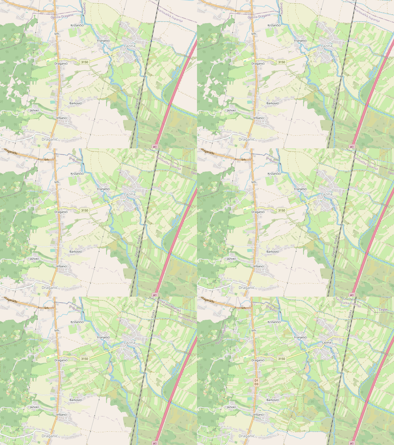
While mapping east of Vrbanci, I noticed that I was almost done with its boundary and completed it.

before and after animation of OpenStreetMap depicting land cover addition mainly farmland, meadow, heath, scrubs, wood, and many other land covers

Quick Overview

See full entry

Location: Lazina, Mjesni odbor Lazina - Franjetići, Draganić, Municipality of Draganić, Karlovac County, 47201, Croatia
Posted by pedrito1414 on 9 September 2023 in English.

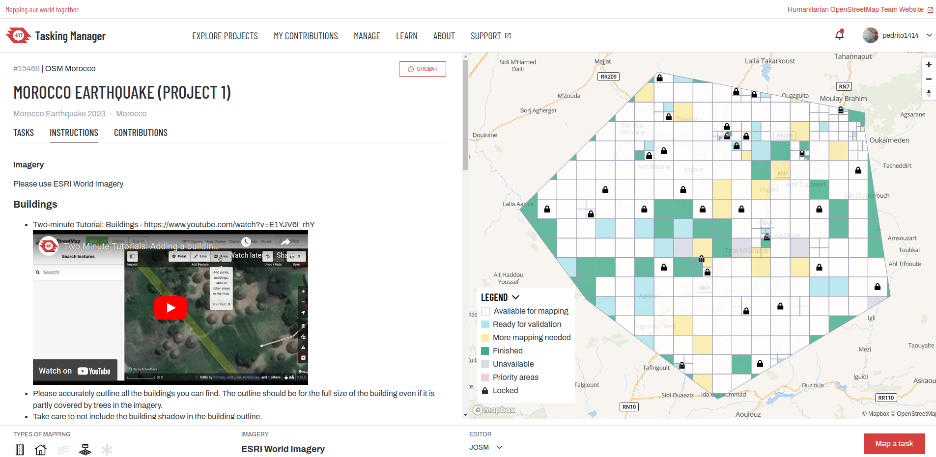
Following the earthquake in Morocco last night (08-09 Sept 2023), staff from HOT’s West and Northern Africa Open Mapping Hub and OSM Morocco agreed to launch an activation to support response efforts.

If you would like to support by mapping, please do. The first project is now on the HOT Tasking Manager and more will follow.

HOT Tasking Manager

You can also keep track via the activation wiki page : 2023 Morocco Earthquake.

If you have questions or would like to engage, you can do so via the HOT slack or the OSM community forum.

Thanks in advance for your time and skills in support!

在随便乱翻的时候翻到了东营的天地图网站,发现有乡镇区划图和“宗地”选项可以覆盖在底图上。这里附上链接 https://www.dysmap.cn/ (我之所以不画是因为在上学 没时间(懒)) (

Location: 东城街道, 东营区, 东营市, 山东省, 257000, 中国
Posted by Black_Diamond on 8 September 2023 in English.

The USGS 3D Elevation Program (3DEP) is awesome. When mapping roads, creeks and trails that are covered by trees, it’s nearly impossible to use any satellite imagery in any meaningful way. Even if someone spends the time to use GPS to track a road or hiking trail, it is even harder to find someone to walk down the middle of a lot of creeks to track the path of the water flow. It’s also not uncommon for the GPS trace to be off by several feet or even have gaps in the data near tall dense trees, which reduces the accuracy of the path being traced on a map. 3DEP can help in such situations.

three dimensional elevation program (3DEP) Logo

I believe that this data is only available for most of the US territories. So if you are mapping outside outside of the US, this may not be beneficial to use.

See full entry

Posted by prispe on 8 September 2023 in English.

On the 6th of September 2023, we the members of the committee had a review on the volume of applications submitted by the applicants for SotM Africa which is slated to be held in Cameroun this year 2923. Letters were sent to the applicants whose application was not successful.

On the 8th, we concluded were 15 of the applicants made it to the top. Letters will be sent to them by the 9th of September, 2023.

Make a Donation to UMBRAOSM Union of Brazilian OpenstreetMap Mappers and keep the site in AR and your projects!

https://www.umbraosm.com.br/doacao.html

These are the data to send a Pix to the Neon account!

To send by keys: Email: umbraosm@gmail.com

Name: Roberto Borges De Sousa

See full entry

Herausforderung: Kartografiere dein Wohnklo!

Dies ist eine Aufforderung an euch alle das Gebäude in dem ihr wohnt in OpenStreetMap ausführlich zu kartografieren, also tragt einfach alle Informationen ein, die ihr über das Gebäude wisst.

Zwei Überlegungen vorab, bevor ich erkläre, wie das am Besten geht:

  1. Es ist wahrscheinlich, dass ihr nicht wollt, dass andere wissen wo ihr wohnt, aber Änderungen in #OpenStreetMap werden natürlich mit dem Account, mit dem sie erstellt werden verknüpft und das ist öffentlich einsehbar. Wenn ihr also nicht wollt, dass jeder herausfinden kann wo ihr wohnt, dann empfehle ich, dass ihr einen OSM-Account anlegt, der nicht euer Standard-Nickname ist. Wenn ihr also normalerweise @flottebiene23 heißt, dann nennt euch einfach Brummer42 oder sogar KcA4TbGsu ist ja auch ein schöner Benutzername. Nur könnt ihr dann halt mit eurer Leistung auch nicht angeben.
  2. Zweck der Aktion ist unter anderem ein paar Leute mit dem OSM-Fieber zu “infizieren”. Also dazu zu bringen, dass sie auch künftig das ein oder andere zur Datenbank beitragen. Schon klar, dass da nur 1% hängen bleiben oder so, aber hey, 1%. Aber es ist natürlich auch schön, wenn einfach ein paar Leute ihr Wohn-Gebäude in OSM mit Daten anreichern, das ist ja auch ein Wert an sich.

Die Idee dazu kam mir unter anderem als ich vergangenes Jahr auf dem #34C3 mit @SWW13 zusammensaß und es mir sagte sein Wohngebäude sei nur so marginal in OSM drin. Daraufhin haben wir den Eintrag ausführlich gepimpt und auch die kleine Sitzbank vorm Haus und den Parkplatz gegenüber und den Glascontainer in Sichtweite noch eingetragen.

Dieser Artikel entstand ursprünglich auf diaspora*, aber ich habe ihn noch auf GitHub kopiert, auf OSM.org und auf mein Wordpress Blog

Also, Bock drauf? Dann los!

Schritt 1: Konto erstellen

See full entry

O Instituto AddressForAll em parceria com a Esri começa a liberar pacotes de dados cedidos por centenas de prefeituras do Brasil e outros países. São mapas de eixos de vias, lotes, edificações, divisas de bairros, pontos de endereços e quadras, que podem ser carregados no QGIS e JOSM para melhorar o OpenStreetMap.

Os dados serão disponibilizados em licença CC0 e CC-BY com permissão para o OSM (as licenças estará no box de metadados de cada pacote de dados) . A primeira cidade liberada é Cachoeiro do Itapemirim/ES, Brasil. Confira post no blog do Instituto.

Post blog AddressForAll: https://blog.addressforall.org/e66bce20076b

Comentários, sugestões e questões para orientar as próximas liberações também são bem-vindos.

(postagem do Instituto AddressForAll)

Location: Centro, Cachoeiro de Itapemirim, Espírito Santo, Região Sudeste, Brasil

Натрапив на дефект у побудові шосейних вело маршрутів в Komoot (на Graphhopper), але це може повторюватись і на інших навігаторах (OSMAnd ітд)

При побудові шосейних треків (коли треба виключно асфальтні дороги), він відмовляється в деяких місцях вести по шосе, а обходить цю ділянку по будь-яких дорогах поруч, включаючи грунтовки і тропи. А якщо примусово прокласти там трек - пише "вам треба буде спішуватись з вело" і збільшує загальний час маршруту.

Проблема виявилась у неповному заповненні тегів якості доріг з порушенням порядку заповнення.

Зазвичай, якщо теги дороги не заповнені, але вказаний її ранг ('trunk', 'primary', 'secondary'), то маршрутизатори вважають її асфальтом.

І ось тут хтось ставить тег якості поверхні smoothness, забуваючи про surface. Коли дорога гарна, хоча б intermediate, проблем ніяких. Але якщо 'smoothness = bad', то маршрутизатор вирішить, що там грунтовка. І навіть ранг дороги 'primary' вже не допоможе, і відправить нашого шосера блукати по реальним грунтовкам

І звісно, це наче проблема розробників, але пошук через Overpass показав, що в Европі дуже мало ділянок з подібною проблемою, лічені випадки.

Можна просто виправити поточні проблемні ділянки в Україні, але постане інша задача. У нас дуже багато шосе не мають тегів типу поверхні (хоча навіть зі супутника видно, що то asphalt). І лише питання часу, коли хтось з маперів поставить знову тег якості поверхні, забувши вказати її тип, чим зробить цю дорогу "непроїздною" для шосейного велосипеда.

І доводиться просто час від часу робити пошук через Overpass

When I started getting involved in mapping on OSM around July 2021, I asked myself: “But why hasn’t anyone made a guide to help me map this country?” and indeed, there was no specific guide to contribute on North Korea!

North Korea Mapping Guide

Beginning

After learning and integrating all the basic OSM tags (including highway=*, building=*, natural=*, landuse=* etc.) and mapping some small towns of the country, I thought about creating a personal page of recurring tags for easy retrieval.

Then the idea came to me to make a thematic page on the contribution specific to this country.

Access to the terrain in North Korea is complicated, and a good understanding of satellite imagery is essential, so a guide to the subject becomes all the more relevant. So I decided to create one!

See full entry

Location: 39.008, 125.752

Revised Script for usage in macOS 12+ with zsh:

#!/bin/zsh
echo "Download"
wget -t0 -c "http://download.geofabrik.de/europe/andorra-latest.osm.pbf"
wget -t0 -c "http://download.geofabrik.de/europe/austria-latest.osm.pbf"
wget -t0 -c "http://download.geofabrik.de/europe/belgium-latest.osm.pbf"
wget -t0 -c "http://download.geofabrik.de/africa/canary-islands-latest.osm.pbf"
wget -t0 -c "http://download.geofabrik.de/europe/czech-republic-latest.osm.pbf"
wget -t0 -c "http://download.geofabrik.de/europe/denmark-latest.osm.pbf"

echo "Convert"
./osmconvert --drop-version andorra-latest.osm.pbf -o=andorra-latest.o5m
rm -rvf andorra-latest.osm.pbf
./osmconvert andorra-latest.o5m -o=merged.o5m
rm -rvf andorra-latest.o5m

for FILE in ./*.osm.pbf; do ./osmconvert --drop-version $FILE -o=$(basename $FILE .osm.pbf).o5m; ./osmconvert $(basename $FILE .osm.pbf).o5m merged.o5m -o=merged_cache.o5m; rm -rvf $(basename $FILE .osm.pbf).o5m; mv -v merged_cache.o5m merged.o5m; done

echo "splitter" 
## latest splitter Version r653 used
java -Xmx5G -jar splitter-r653/splitter.jar --output-dir=tiles --max-nodes=1200000 merged.o5m

echo "mkgmap"
## latest mkgmap Version r4910 used
## template 2022pn.typ used, use what you like :)
java -Xmx5G -jar mkgmap-r4910/mkgmap.jar --country-name=OSMMap --family-name="OSM map" --product-version=1 --bounds=bounds-latest --dem-interpolation=auto --make-poi-index --poi-address --unicode --index --split-name-index --gmapsupp --report-routing-islands -c mkgmap-r4910/examples/sample.cfg -c tiles/template.args 2022pn.typ --style-file=../ --check-styles --route --net --gmapi --add-boundary-nodes-at-admin-boundaries

echo "final clean up"
rm -rvf *latest.o5m
rm merged.o5m
cd tiles
rm -rvf *.osm.pbf
cd ..
rm -rvf 6*.img 
rm -rvf ovm_6*.img

echo "The End"