OpenStreetMap logo OpenStreetMap

Users' Diaries

Recent diary entries

Tree mapping is a task that is better done in person than using aerial imagery, unless it is a tree row. The reasoning being that node placement of natural=tree is more precise than looking from above, since more often than not the imagery is not that clear.

Trees tell a story

When looking at this area it is fascinating how one can make out man made structures relative to the placement of trees.

trees and tree rows as nodes and ways in JOSM

Further once adding the leaf_cycle and leaf_type one can create shade maps that could be practical during heat waves like at mapasdesombra.org or if jveuxdusoleil.fr extended its algorithm to include tree details as well.

One can add the tree’s height and diameter with a check date to create a timeline of the tree’s lifespan, though also add more potential data points in ecological terms.

Or one can add the genus and/or species to ease the search for foragers like mundraub does with their overlay map.

Tree specification

See full entry

Posted by qeef on 3 September 2023 in English.

The damn deploy repository of the Divide and map. Now. has been refactored. And that’s a great opportunity for another round of load testing.

This is the third round of load testing, see the first and the second one if you are interested.

The load testing is a bit different from the last time. I performed load testing of new, freshly deployed damn project instance on $6/month VPS with 1 GB RAM, single 2.5 GHz vCPU, and 25 GB SSD. (The changes from the last time are that there is no more load testing of the “production” server, the price increased by $1/month, and shared_buffers is now 256 MB instead of 409 MB.)

The preparation for load testing on the server’s side, when the damn project is deployed, is just to run

docker-compose -f damn-deploy/gen.yml run --rm prepareloadtest

to create 1000 test users and 10 (load) testing areas in the database. For each run of load testing, the database has been deleted and created again with

systemctl stop damn-http.service
reboot
docker volume rm damn-deploy_damndb-volume
systemctl start damn.target
docker-compose -f damn-deploy/gen.yml run --rm prepareloadtest

commands. For each run of load testing, log the server’s utilization with

sar -o load-test-100 -A 15 $((4 * 61)) 1>/dev/null 2>&1

Then, from that file, you can generate data series and plot the graphs with

./get-info.sh 100
gnuplot plot1.pl
gnuplot plot2.pl

where the content of the corresponding files is

get-info.sh:

See full entry

Como presidenta do Instituto Virtual para o Desenvolvimento Sustentável - IVIDES.org, idealizei, organizei e ministrei o curso de “Capacitação em mapeamento com OpenStreetMap”, para dar início às atividades do Capítulo YouthMappers UFRJ, Rio de Janeiro, Brasil, do qual, sou também presidenta e conto com a colaboração do Dr. Manoel Fernandes, professor mentor; do Dr. Paulo Menezes, professor mentor colaborador, todos nós do Lab. GeoCart-UFRJ; e ainda, com a fundamental colaboração de alunos e alunas do nosso laboratório e de unidades vizinhas do Centro de Ciências Matemáticas e da Natureza, especificamente, da Geologia; da Meteorologia e da Ciência da Computação e Núcleo de Computação Eletrônica - NCE. Poderia desfiar um rosário de instituições nacionais, principalmente do Rio de Janeiro, que fazem parte do nosso grupo de pesquisa, mas estou aqui para falar do nosso curso!

Apresentação do curso

O curso foi ministrado entre os dias 20 de julho e 24 de agosto de 2023 e transformou-se em um curso de fluxo contínuo, uma vez que houve interesse de demais pessoas, que conheceram a iniciativa após o início de sua realização. Assim, aos participantes que concluirem com sucesso - vide as condições presentes no portal https://ivides.org/curso-osm-2023, serão emitidos certificados ao final das fases de seis meses. Os envios de resultados são realizados por esta mesma plataforma e os certificados serão enviados por e-mail cadastrado no curso (vide no mesmo local, o portal web, as informações sobre a Secretaria).

See full entry

Posted by scruss on 3 September 2023 in English.

… unless you want a greatbighuge label inexplicably hovering over the map at z=16.

Looking over this fine city of Toronto, I saw a couple of brown labels for places that are sort-of not real. Exporting and grepping local exports showed me they were landuse ways with a name value set.

I’m sure there are plenty of good examples where a landuse area would have a name. In these cases, though:

  • one was the name of a city/developer study from roughly five years ago that has disappeared from the record since then. Will it become a neighbourhood name? Who knows, but that’s for the future and not for us to force. (fun fact: it’s apparently the densest concentration of office workers in the city. Less fun but very Toronto fact: there is no dedicated transit there. I had a job there ~2006–2008 and new transit was planned, but then the trainwreck formerly known as Mayor Rob Ford happened so it didn’t.)

  • one was a drive-by tagging error by an out-of-band specialist. I really think they meant it for a bus stop.

Aligned with my personal policy of “Only kvetch after fixing”, they’re gone and our z=16 will be so much less jarring. Thank me later.

Posted by pnorman on 1 September 2023 in English.

The Standard Tile Layer has a lot of traffic. On August 1st, a typical day, it had 2.8 billion requests served by Fastly, about 32 thousand a second. The challenges of scaling to this size are documented elsewhere, and we handle the traffic reliably, but something we don’t often talk about is the logging. In some cases, you could log a random sample of requests but that comes with downsides like obscuring low frequency events, and preventing some kinds of log analysis. Critically, we publish data that depends on logging all requests.

We query our logs with Athena, a hosted version of Presto, a SQL engine that, among features, can query files on an object store like S3. Automated queries are run with tilelog, which publishes files daily to generate published files on usage of the standard tile layer.

As you might imagine, 2.8 billion requests is a lot of log data. Fastly offers a number of logging options, and we publish compressed CSV logs to Amazon S3. These logs are large, and suffer a few problems for long-term use because they:

  1. contain personal information like request details and IPs, that, although essential for running the service, cannot be retained forever;
  2. contain invalid requests, making analysis more difficult;
  3. are large, being 136 GB/day; and
  4. become slow to query, being compressed gzip files with the only indexing being the date and hour of the request, which is part of the file path.

To solve these problems we reformat, filter, and aggregate logs which lets us delete old logs. We’ve done the first two for some time, and are now doing the third.

See full entry

Posted by Heather Leson on 31 August 2023 in English.

How do we better organize to support the Humanitarian OpenStreetMap Team organization, staff, membership, and community? We have been on a journey to open up and consider what is the best way forward for HOT’s Governance. Now that we have the HOT Living Strategy, we have more incentive to imagine how we might evolve. We are taking stock of our governance and investigating how we might be able to encourage more people to engage in the governance of HOT.

The HOT Governance Working Group (GWG) started the process of research and engagement with the HOT membership in January 2023. We’ve documented this process in the GWG meeting minutes. Together we designed a terms of reference to hire support to help us research some initial bylaw adjustments and wider organizational needs and structures.

Our first big research is exploring how we govern with the board and to better support the membership chair. There will be future steps and research to consider the role of the membership and how we collaborate with the Open Mapping Hubs.

The board and membership asked us to consider the following topics: the possibility of appointed board members, board member stipends, and membership chair term. See the current HOT bylaws

Why the proposed changes

The HOT voting members have a wide range of skills, and have brought much insight and change to the organization. Currently, HOT’s board is elected from and by the voting membership. Over the past years, HOT board and organization have identified gaps in key expertise for the board, including legal, finance and large-scale fundraising. This has been documented in various OSM diary posts, the HOT board election discussions, and the Board and GWG meeting minutes.

See full entry

Location: Kemptville, North Grenville, Leeds and Grenville Counties, Eastern Ontario, Ontario, K0G 1J0, Canada

今天把好多原来是一整块的小区乡村分割然后补名字。晚上又试着给了几个小区画建筑…… 要开学了,以后可能就没有这样的机会画这么多了……唉 啊对 还有街道分界线问题……有空亲自去东边看看吧

Location: 王庙镇, 鱼台县, 济宁市, 山东省, 中国
Posted by MKnight on 29 August 2023 in German (Deutsch).

… wenn das Gute liegt so nah …

Ich hab mal für Leute mit etwas schmalerem Geldbeutel ‘ne Sammlung an deutschen Reisezielen zusammengestellt, die man zum Einen unbedingt gesehen haben muss und zum anderen man nach der Reise viel zu erzählen (oder besser zu erklären?) hat…

Das isse, viel Spass: osm.wiki/User:Dex2000#%22sch%C3%B6ne%22_Reiseziele_in_Deutschland

P.s. Wenn ich mich recht entsinne, war ich nur an einem dieser Orte. Welcher, wird nicht verraten, sonst klickt ja niemand…

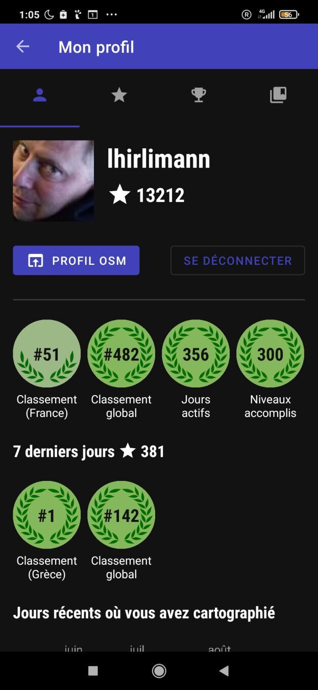
Last week I had a week of vacation in beautiful Greece. As I needed to do some kind of daily exercise, I decided to walk and played with streetcomplete. I’ve been off the app for a few months due to lack of motivation. After one hour of going around and adding things I looked at my profile and was #1 on Greece what a shock. Screenshot of my streetcomplete profile showing me being number 1 in Greece after 3 days

Wondering how that could be?

  • Are all greeks using iphone? (I doubt)
  • Is no one using OSM in Greece? (I doubt)
  • Is Streetcomplete missing some greek translation (probably, I didn’t check).
  • Am I the only one doing streetcomplete while on vacation?
Location: Kato Spileo, Agios Dimitrios, Municipal Unit of Meliteieis, Municipality of Southern Corfu, Corfu Regional Unit, Ioanian Islands, Peloponnese, Western Greece and the Ionian, 490 80, Greece

OSM에는 왜 이렇게 흐릿한 갈래가 많을까……

외국 사람들에게 한국의 ‘곰’, ‘탕’, ‘국’을 갈래지으려면 갈래지을 수 있을까?

도대체가 말이 안 되는 짓거리를 언제까지 하고 있을 건가…… ㅡ.ㅡ


Why does OSM have so many fuzzy branches……

Is it really possible to make Korean ‘gom’, ‘tang’, and ‘guk’ forked for foreigners?

How long are we going to keep doing this nonsense…… ㅡ.ㅡ

Hello! Today, I want to share a handy script that can enhance your experience with JOSM on MacOS by enabling a dark mode theme. Dark mode not only looks sleek but can also reduce eye strain, especially during late-night mapping sessions.

Note: This script is specifically for MacOS users.

Step 1: Download JOSM

If you haven’t already, download the latest version of josm-tested.jar here. Save it to a location on your Mac.

Step 2: Install the FlatLaf Plugin

FlatLaf is a fantastic plugin that allows you to apply dark themes to Java applications. After installing the plugin and restarting, go to the menu and select the dark theme: JOSM → Settings → Display → Look and Feel → FlatLaf Darcula

Step 3: Create and Run the Script

Now, let’s create a script that will launch JOSM with a dark theme. Open your favorite text editor and paste the following code:

shell #!/bin/zsh

java -Dapple.awt.application.appearance=NSAppearanceNameDarkAqua -Xmx7168m -jar /Users/YourUsername/Documents/josm-tested.jar

Make sure to replace YourUsername with your actual MacOS username. This script does the following:

  • #!/bin/zsh: Informs your system to use the Zsh shell to execute the script.
  • java -Dapple.awt.application.appearance=NSAppearanceNameDarkAqua -Xmx7168m -jar /Users/YourUsername/Documents/josm-tested.jar: Launches the Java runtime with dark mode enabled, allocates 7168MB (or 7GB) of RAM to JOSM (you can adjust this value), and specifies the path to your JOSM JAR file.

Step 4: Save and Make the Script Executable

Save this script with a .command extension, for example, josm-dark-mode.command. To make it executable, open your terminal, navigate to the directory where you saved the script, and run the following command:

shell chmod +x josm-dark-mode.command

Step 5: Execute the Script

Now, you can simply double-click josm-dark-mode.command, and JOSM will launch with a beautiful dark theme, thanks to the FlatLaf plugin and the MacOS appearance setting.

See full entry

Location: Cape Town Ward 115, City of Cape Town, Western Cape, 8001, South Africa

Introduction

Hi everyone, this is my final report for my GSoC’23 project: support Vespucci preset extensions in JOSM.

Previous diary entries

Getting started

Project Summary

About the project

Vespucci utilizes the JOSM preset format but has extended the configuration to work better outside of the narrow realm of JOSM. The project aimed at adding these additional extensions in JOSM. These extensions include deprecated, regions, exclude_regions, value_type, and alternative. see Vespucci preset documentation

Work done

The presets can have the additional attribute “regions”, which will contain the ISO codes of the countries to which the preset is applicable. “exclude_regions” will invert the meaning of “regions”, i.e., the preset should not be applied in countries specified under “regions”.

A warning message is displayed before the upload if the preset is applied in the country not defined in the “regions”.

See full entry

Posted by barefootstache on 27 August 2023 in English.

It has been just over a week that I have accomplished the 365 daily MappingChallenge (Mastodon) and decided to persist with a 100 weekly challenge instead. One of the main (Mastodon) reasons is how daily contributions are being processed based off of UTC+0, which is manageable if one does not travel. Further this week I have decided to use the OSM Diary over Mastodon, since this way I can do long form entries with less constraints and possibly reach a larger audience.

Quick overview

In week 54:

  • 34 change sets created in total
  • 5327 node changes in total

all were done within JOSM.

Changes

  • extracting sidewalks from roads
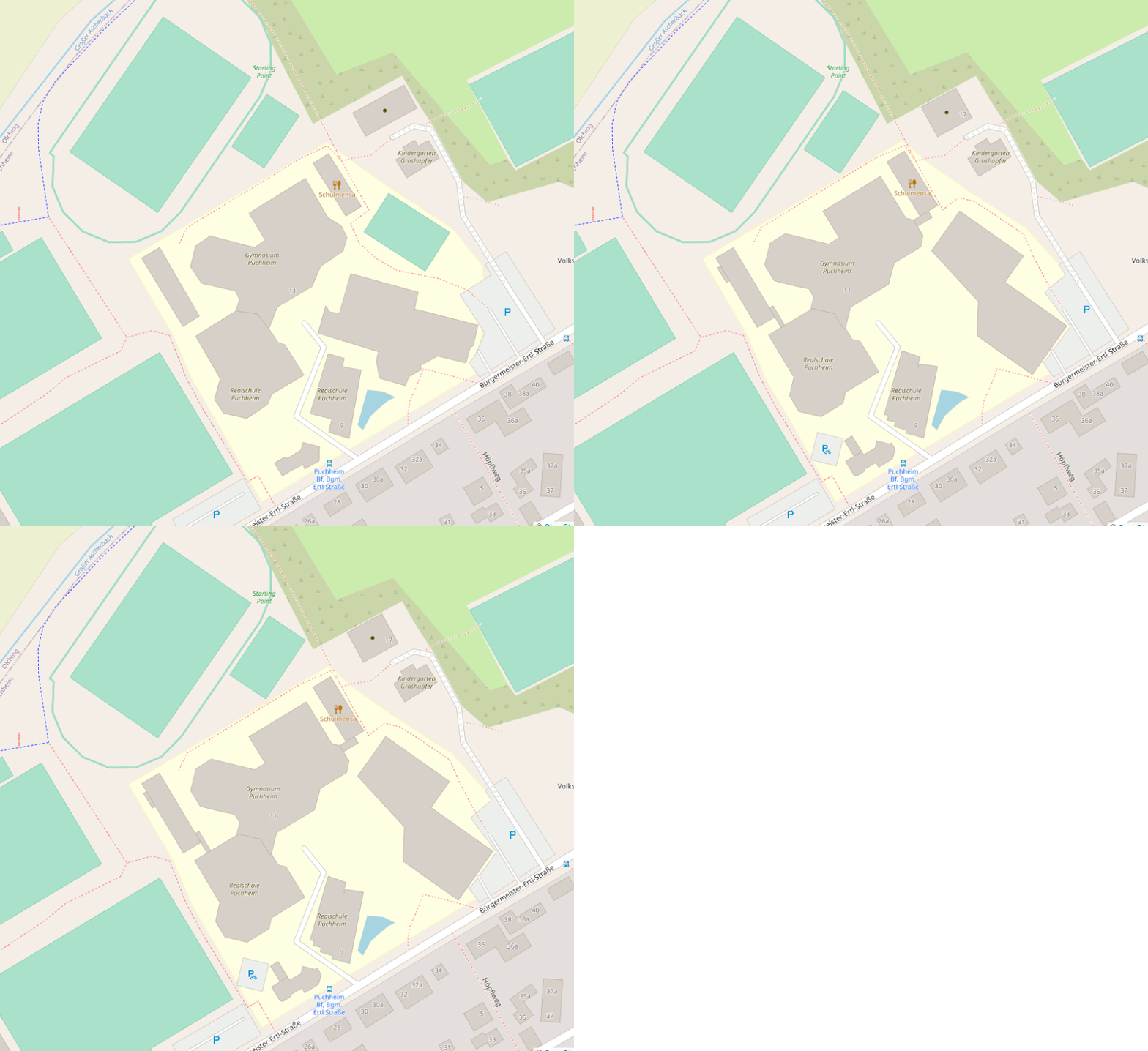
  • splitting up schools
  • adding roof shape and roof material

Puchheim Realschule and Gymnasium

Location

Before and after animation of building geometry changes of a school district

Puchheim Mittelschule and Grundschule

Location

See full entry