Users' Diaries

Recent diary entries

Posted by MKnight on 29 August 2023 in German (Deutsch).

… wenn das Gute liegt so nah …

Ich hab mal für Leute mit etwas schmalerem Geldbeutel ‘ne Sammlung an deutschen Reisezielen zusammengestellt, die man zum Einen unbedingt gesehen haben muss und zum anderen man nach der Reise viel zu erzählen (oder besser zu erklären?) hat…

Das isse, viel Spass: osm.wiki/User:Dex2000#%22sch%C3%B6ne%22_Reiseziele_in_Deutschland

P.s. Wenn ich mich recht entsinne, war ich nur an einem dieser Orte. Welcher, wird nicht verraten, sonst klickt ja niemand…

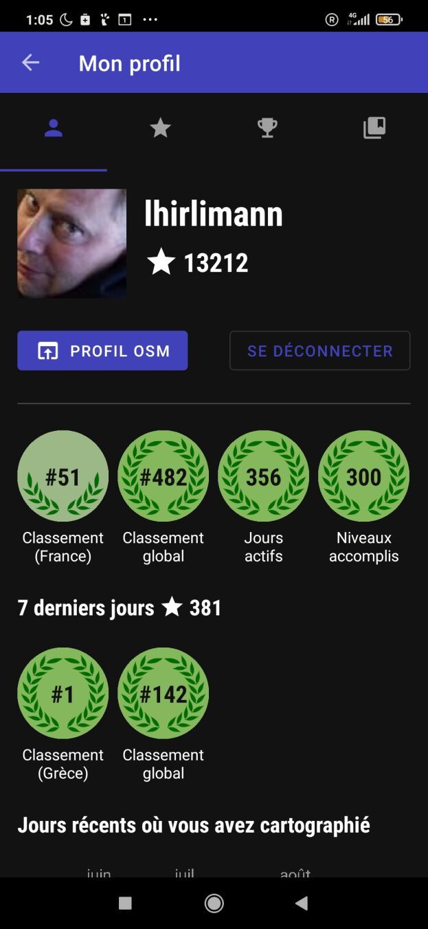
Last week I had a week of vacation in beautiful Greece. As I needed to do some kind of daily exercise, I decided to walk and played with streetcomplete. I’ve been off the app for a few months due to lack of motivation. After one hour of going around and adding things I looked at my profile and was #1 on Greece what a shock. Screenshot of my streetcomplete profile showing me being number 1 in Greece after 3 days

Wondering how that could be?

  • Are all greeks using iphone? (I doubt)
  • Is no one using OSM in Greece? (I doubt)
  • Is Streetcomplete missing some greek translation (probably, I didn’t check).
  • Am I the only one doing streetcomplete while on vacation?
Location: Kato Spileo, Agios Dimitrios, Municipal Unit of Meliteieis, Municipality of Southern Corfu, Corfu Regional Unit, Ioanian Islands, Peloponnese, Western Greece and the Ionian, 490 80, Greece

OSM에는 왜 이렇게 흐릿한 갈래가 많을까……

외국 사람들에게 한국의 ‘곰’, ‘탕’, ‘국’을 갈래지으려면 갈래지을 수 있을까?

도대체가 말이 안 되는 짓거리를 언제까지 하고 있을 건가…… ㅡ.ㅡ


Why does OSM have so many fuzzy branches……

Is it really possible to make Korean ‘gom’, ‘tang’, and ‘guk’ forked for foreigners?

How long are we going to keep doing this nonsense…… ㅡ.ㅡ

Hello! Today, I want to share a handy script that can enhance your experience with JOSM on MacOS by enabling a dark mode theme. Dark mode not only looks sleek but can also reduce eye strain, especially during late-night mapping sessions.

Note: This script is specifically for MacOS users.

Step 1: Download JOSM

If you haven’t already, download the latest version of josm-tested.jar here. Save it to a location on your Mac.

Step 2: Install the FlatLaf Plugin

FlatLaf is a fantastic plugin that allows you to apply dark themes to Java applications. After installing the plugin and restarting, go to the menu and select the dark theme: JOSM → Settings → Display → Look and Feel → FlatLaf Darcula

Step 3: Create and Run the Script

Now, let’s create a script that will launch JOSM with a dark theme. Open your favorite text editor and paste the following code:

shell #!/bin/zsh

java -Dapple.awt.application.appearance=NSAppearanceNameDarkAqua -Xmx7168m -jar /Users/YourUsername/Documents/josm-tested.jar

Make sure to replace YourUsername with your actual MacOS username. This script does the following:

  • #!/bin/zsh: Informs your system to use the Zsh shell to execute the script.
  • java -Dapple.awt.application.appearance=NSAppearanceNameDarkAqua -Xmx7168m -jar /Users/YourUsername/Documents/josm-tested.jar: Launches the Java runtime with dark mode enabled, allocates 7168MB (or 7GB) of RAM to JOSM (you can adjust this value), and specifies the path to your JOSM JAR file.

Step 4: Save and Make the Script Executable

Save this script with a .command extension, for example, josm-dark-mode.command. To make it executable, open your terminal, navigate to the directory where you saved the script, and run the following command:

shell chmod +x josm-dark-mode.command

Step 5: Execute the Script

Now, you can simply double-click josm-dark-mode.command, and JOSM will launch with a beautiful dark theme, thanks to the FlatLaf plugin and the MacOS appearance setting.

See full entry

Location: Cape Town Ward 115, City of Cape Town, Western Cape, 8001, South Africa

Introduction

Hi everyone, this is my final report for my GSoC’23 project: support Vespucci preset extensions in JOSM.

Previous diary entries

Getting started

Project Summary

About the project

Vespucci utilizes the JOSM preset format but has extended the configuration to work better outside of the narrow realm of JOSM. The project aimed at adding these additional extensions in JOSM. These extensions include deprecated, regions, exclude_regions, value_type, and alternative. see Vespucci preset documentation

Work done

The presets can have the additional attribute “regions”, which will contain the ISO codes of the countries to which the preset is applicable. “exclude_regions” will invert the meaning of “regions”, i.e., the preset should not be applied in countries specified under “regions”.

A warning message is displayed before the upload if the preset is applied in the country not defined in the “regions”.

See full entry

Posted by barefootstache on 27 August 2023 in English.

It has been just over a week that I have accomplished the 365 daily MappingChallenge (Mastodon) and decided to persist with a 100 weekly challenge instead. One of the main (Mastodon) reasons is how daily contributions are being processed based off of UTC+0, which is manageable if one does not travel. Further this week I have decided to use the OSM Diary over Mastodon, since this way I can do long form entries with less constraints and possibly reach a larger audience.

Quick overview

In week 54:

  • 34 change sets created in total
  • 5327 node changes in total

all were done within JOSM.

Changes

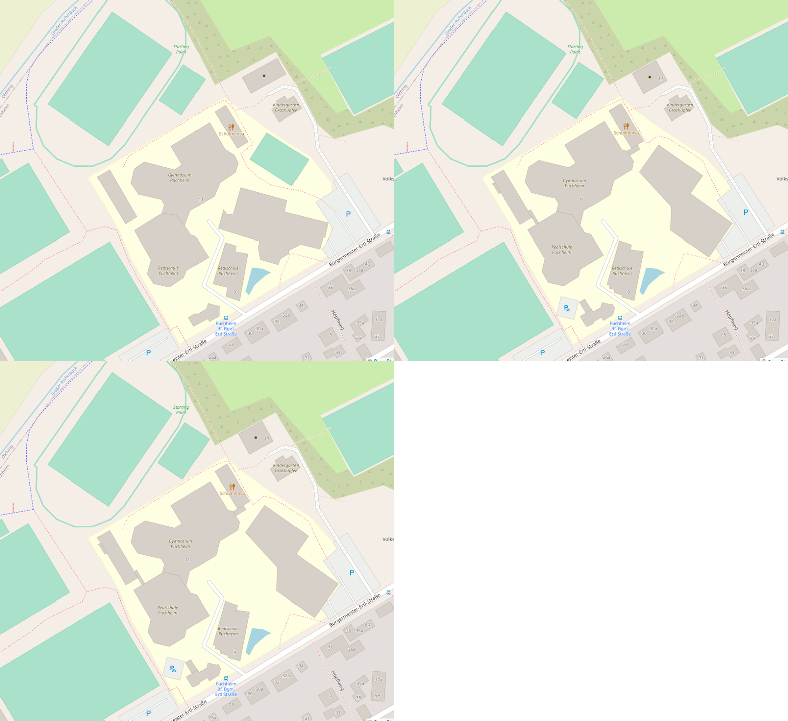
  • extracting sidewalks from roads
  • splitting up schools
  • adding roof shape and roof material

Puchheim Realschule and Gymnasium

Location

Before and after animation of building geometry changes of a school district

Puchheim Mittelschule and Grundschule

Location

See full entry

Após desfrutar de um delicioso café da manhã no encantador distrito de Lapinha da Serra, partimos animados para a desafiadora travessia da majestosa Serra do Tabuleiro. Essa região é um verdadeiro tesouro natural, repleta de características únicas que encantam os aventureiros.

Durante nossa jornada, fomos agraciados com paisagens deslumbrantes e uma diversidade impressionante de vegetação. A serra é famosa por abrigar formações rochosas, cânions exuberantes, cachoeiras cristalinas e uma rica fauna e flora

Uma das partes mais desafiadoras da travessia foi a ascensão ao cume do Breu, onde praticamente precisamos nos aventurar em uma escalada. Lá em cima apreciamos ainda mais a grandiosidade da serra.

Por volta das 15 horas, atravessamos o Rio Parauninha, claro que não deixamos de entrar. Próximo a esse local, descobrimos um trecho que foi carinhosamente nomeado de Prainha, uma área com areia qu simula uma praia, embora alimentada pelas águas do rio. Foi nesse momento que nos deparamos com o primeiro e único grupo que encontramos durante toda a travessia. Admiramos sua iniciativa de explorar a região em bicicletas.

Ao longo do caminho, passamos por diversas porteiras. Cruzamos campos onde rebanhos de bois e vacas pastavam tranquilamente, em meio a uma paisagem que parecia ter saído de um cartão postal.

Enquanto o sol se punha, continuamos em nossa caminhada, proporcionando um espetáculo visual único.

Enfim, chegamos ao acampamento, onde nos acomodamos, relembramos os desafios superados e nos preparamos para descansar. A sensação de realização e gratidão nos acompanhou enquanto nos entregávamos ao merecido descanso.

Location: Lapinha da Serra, Santana do Riacho, Minas Gerais, Região Sudeste, Brasil
Posted by b-unicycling on 27 August 2023 in English.

Heritage Week is an annual number of days (it’s longer than a week by now) taking place in August in Ireland. There is a wide array of events including talks, workshops, guided walks etc all around built and natural heritage. This year’s topic was “Living Heritage”.

Recording Milk Churn Stands

Early on in my effort to map milk churn stands in Ireland, I thought that it was not sustainable for me to travel around the country and look for the needle in the haystack, when the locals knew where all the milk churn stands were. So I decided to give a talk which would hopefully raise awareness about the endless possibilities OpenData, OpenSource and OpenStreetMap offers. It was supposed to be a workshop, but I had a funny feeling that the demographic of the audience would turn it into a talk. It actually turned out to be the first event on the Heritage Week website. The Minister for Heritage (, Housing & Electoral Reford) who I happen to be friends with offered to attend, and of course I thought that would be a great opportunity to promote OSM.

The venue was a library in a rural town which used to have a creamery, because I thought it might attract people who remembered the time when milk churn stands (aka creamery stands) were still in use. Once the librarians heard that the minister was attending, they got a bit excited and let the regional library manager know. The big day arrived on August 16th, and he did attend. I had brought the OSM Ireland pull-up poster for the photo op, and also for branding awareness reasons. - So many people still don’t know about OSM, even though everyone by now must have been exposed to it one way or another.

See full entry

Location: Talbotsinch, Talbot's Inch, Kilkenny Rural, Kilkenny, County Kilkenny, Leinster, Ireland
Posted by miku0 on 27 August 2023 in English. Last updated on 29 August 2023.

Hi everyone,

I am thrilled to present the final updates on my ongoing project focused on enhancing the search experience in Japan. For reference, you can find the previous blog entry here and the interim report here. In the last interim report, I introduced the changes related to the sanitizer. The associated pull requests for these changes can be accessed here. Regarding this article, you can find the pull request for this specific change here.

In this final update, I will provide detailed insights into our efforts in the “Address Search” realm, specifically related to the tokenizer.

Enhancements in Address Search Methods in Japanese

Japanese Addresses are written in one large string without spaces and Nominatim needs help to find the words. As an illustration, for instance, consider the Japanese address “東京都新宿区西新宿2丁目8−1”. Although it lacks spaces, it can be divided into internal segments such as “東京都” (similar to a state or district), “新宿区” (akin to a city), “西新宿” (akin to a town), and “2丁目” (a block). However, Nominatim only divides such addresses using ICU (International Components for Unicode) transliteration, not based on this semantic division. Fig.1 illustrates a debugging example with multiple potential candidates.

See full entry

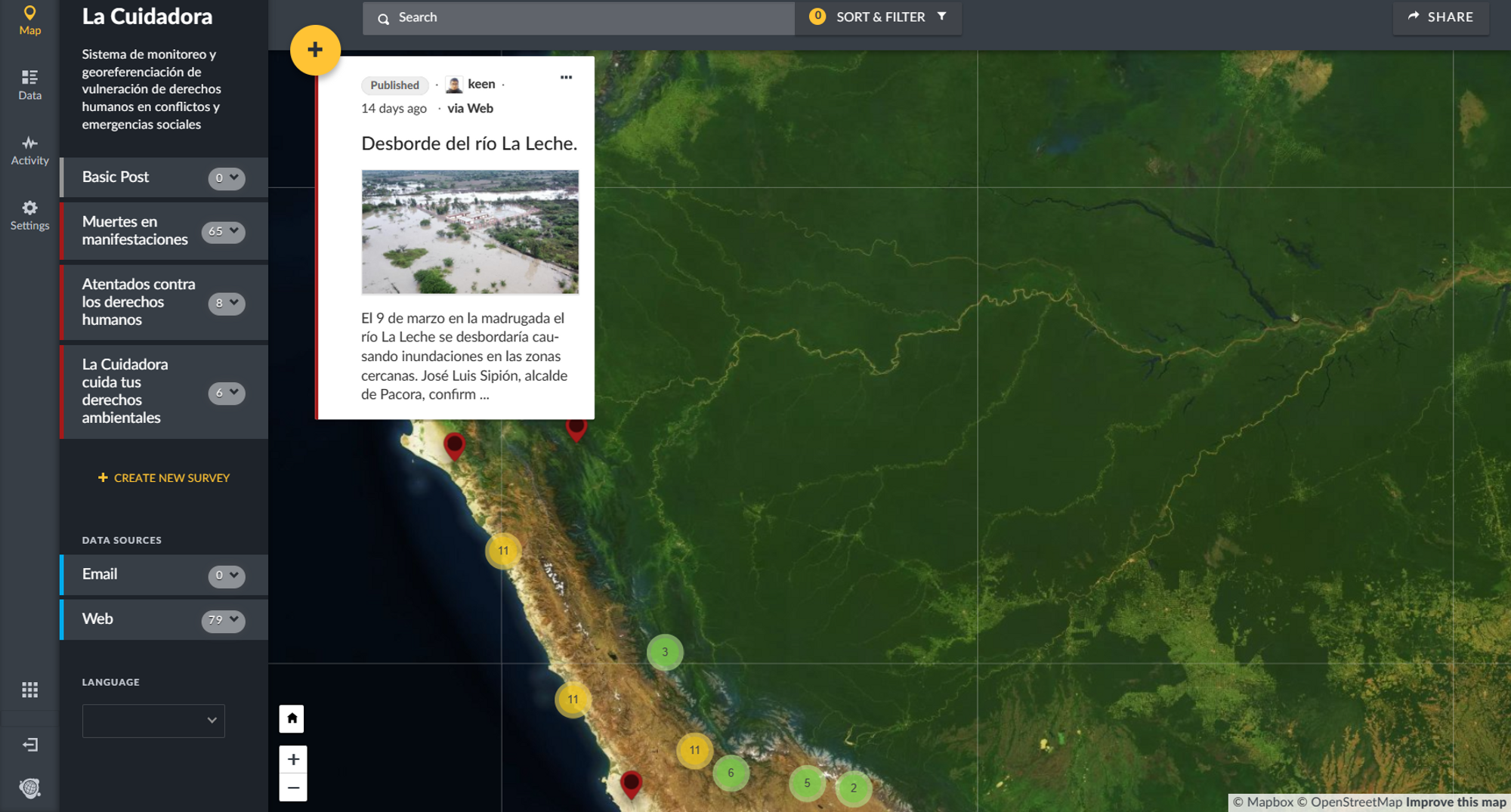
La Cuidadora

“La Cuidadora es un sistema de monitoreo y sistematización de atentados contra los derechos humanos. La plataforma se desenvuelve de forma colaborativa y abierta, pudiendo cualquiera de los usuarios subir un caso de manera anónima. Funciona como un mapa interactivo en el que se pude geolocalizar el punto exacto o referencial del hecho, además de poder recopilarse una serie de datos en las viñetas, desde el nombre de los actores y la descripción del evento hasta el día en el que ocurrió.”

  1. ¿Cómo solucionaremos nuestros problemas?: La Cuidadora

La Cuidadora te cuida

OpenStreetMap como una política educativa global: Aprendizajes desde el Perú

Hace meses publiqué mi primer artículo sobre mis impresiones y perplejidades al respecto de OpenStreetMap, espero sean de utilidad para la comunidad, sino, pues lo intenté, me gustaría iniciar una literatura entera sobre OSM en el Perú, solo estoy pensando en voz alta. Aquí link:

  1. OpenStreetMap como una política educativa global: Aprendizajes desde el Perú
  2. También publicado en YouthMappers
  3. También por los amigos de Bolivia, Pachakamani Conferencia en el auditorio José María Arguedas en la Facultad de Ciencias Sociales en la Universidad Nacional Mayor de San Marcos en el marco del evento Gestión Popular del Riesgo del Desastre + GRD.
Location: Los Cipreses, Lima, Lima Metropolitana, Lima, 07006, Perú

Project name: Guidelines for mapping of wetlands and floodzones. Case study of Lower Sinu river basin in Caribean region of Colombia

Description

The goal of the project is to test the mapping case study to build a document with guidelines for mapping in this areas. It comes from the experience of the “Water telling stories” Social Movement, a root social initiative of near 47 communities, grassroots organizations from 5 municipalities around the ecosystem of the Lower Sinu River Basin, located in the north coastal side of the Cordoba Department, in the Caribean region of Colombia. As part of the technical support team of the movement, Iḿ leading the mapping project for this area.

More info:

I used the jamboard to put one the difficulties from my side:

“I can’t find allies for my legacy project from my OSM local and regional Community. I need people to help me to identify the needs of mapping wetlands and flood areas.”

I’m working with one volunteer from Youth mappers in Colombia who is interested in help to this mapping project. As I said in my diary entry, previously I had lead one mapping session to invite people to join our tasking manager mapping task to map Bajo Sinu “Lower Sinu River basin”.

In my action plan I have:

See full entry

Location: Lorica, Bajo Sínú, Córdoba, Colombia
Posted by pb07 on 26 August 2023 in French (Français). Last updated on 30 January 2024.

Réseaux de carrefours

Dans beaucoup de régions les offices de tourisme proposent des boucles de randonnées décrites dans des topoguides imprimés ou accessibles sur intenet.
La plupart du temps, sur le terrain ces boucles sont complétées par des itinéraires de liaison, balisés aussi, mais il est souvent difficile d’en trouver une cartographie détaillée. Des panneaux Info rando dans les villages montrent que l’ensemble boucles + liaisons forme en fait un réseau de carrefours : tronçons balisés reliant deux carrefours indiqués par des poteaux.

Depuis quelque temps, des contributeurs d’OpenStreetMap travaillent à intégrer ces réseaux de carrefours dans la base de données OpenStreetMap. Pour ma part, j’ai intégré une bonne partie du réseau en Ardèche Sud (plus de 1700 km actuellement).

Ces réseaux apparaissent dans plusieurs visualisations : Waymarkedtrails, Knooppuntnet, Thunderforest outdoors

J’ai par ailleurs développé un outil, basé sur Leaflet, permettant de visualiser ces réseaux sur différents fonds de carte, de construire de proche en proche un itinéraire personnel dans le réseau puis de l’exporter sous forme de fichier GPX. Voir par exemple le réseau Ardèche Sud : Itinéraires Ardèche Sud.

Moyennant quelques requêtes Overpass, cet outil peut être adapté à n’importe quel réseau de carrefours.