OpenStreetMap logo OpenStreetMap

Users' Diaries

Recent diary entries

Hello everyone, better late than never, and yeah, that’s my first time here =D

This is meant to be a testimonial covering a somewhat more technical part, for a more “fun” version, I made a thread on Twitter* with LOTS of good photos!! (last year I’ve made a similar) !!

Well, in the beginning, I wasn’t expecting to even be at the event, like, another continent, too expensive travel… I’ve submitted my piece of work, that I was already working on It was (accepted)[https://talks.osgeo.org/foss4g-2023/talk/CRPWUS/]!

Then I’ve been approved for the travel grant program and also as a volunteer!!! I was so so glad, then I need to say thanks again for OSGEO, FLOSSK, UFPR, and HOT they were the ones that made the travel possible!!

Kosovo is a lovely country, there’s amazing and quite affordable food everywhere! Also, the locals and the “locals”, but from Albania (I found this shared sense of belonging very enchanting) received me very well, I got to know many badass people from FOSS community, like the giants from OpenLabs and Cloud 68, they are incredible people and contributors, now I’m really eager to get to know Tirana!

Now getting to the promised technical part: I saw so many solutions and applications, It’s so amusing to see ever-growing FOSS software, including in fields like 3D GIS and even digital twins fancy stuff.

As an OSM lover what I found most heartfelt was that everyone was so fond of OSM there, all applications with base maps had some OSM flavor/derived there, and all making analysis using OSM as the main or one of the data sources…

See full entry

Location: Kurilat, Kurilla, Municipality of Prizren, District of Prizren, 20080, Kosovo

Do we (OSM) have a league table for all countries/ entities (non-countries?), which is based on the quality of OSM mapping in that country?

I ask this question, because I was undertaking a MapRoulette challenge, to help with mapping in Algiers, and although some pockets of excellent mapping existed, it seemed clear that this was very much the exception.

  1. How do we gather metrics, to assess the quality of mapping in a given country, so that quality can be improved?

  2. How do we engage with the ‘local’ OSM community, to perhaps help them to improve mapping?

  3. Can we define a regular (and repeatable) set of MapRoulette challenges, that would enable remote mapping to be carried out, in support of ‘hands-on’ mapping/ surveying carried out by ‘locals on the ground’?

  4. How do we publicise tools such as StreetComplete, to help populate the data/ metadata of a country, in order to build upon the ‘big picture’ data that is gathered?

  5. What are we missing, above?

Please add to this, and edit, as appropriate.

Many thanks,

Chris

Posted by Tomas_J on 30 July 2023 in English. Last updated on 19 April 2025.

My personal list of the OSM projects for Slovakia (assorted by importance):

  • house numbers adding
  • cyclo routes adding
  • tracks adding (based on strava heatmap)
  • new bildings adding based on ortophoto
  • wikidata and wikipedia tags adding
  • waterways adding
  • railways tracks (re-)numbering
  • cry me a river - river precising
  • run forest run - forests’ precising
  • changes sets` review requests from new users
  • railway lines (long distance, commuters) - https://loom.cs.uni-freiburg.de/global
  • school/ agricultular (ex. JRD) areals
  • 3D buildings (churches, POI buildings…)
  • roundabouts precising
  • rail and informal path crossings’ access (type: node child railway child (highway=path -access=no)) -maxspeed -missing power lines

ToDos:

Welcome tool - https://welcome.osm.be/europe

Surfaces - https://data.humdata.org/m/dataset/slovakia-road-surface-data

JuRaVa cycloroute - to map by armchair mapping

Oprava názvov ulíc| Wikidata

Location: Očová, District of Zvolen, Region of Banská Bystrica, Stredné Slovensko, 962 23, Slovakia

Inspired by my endeavours to create a colour-coded map of sewer vents/ stink pipes by manufacturer, and by my county council’s endeavour to undertake a survey of holy wells, I started adding name:etymology:wikidata first to the holy wells in Co. Kilkenny, but then to the whole of Ireland.

I had produced a video about mapping holy wells in March 2021, but I think I need to make an updated one, because I was oblivious of the name:etymology group, and instead, had suggested people use subject:wikidata. Silly me. But at least, I only had to retag some of them rather than looking up every name.

Some saints or holy people like St. Patrick and “Our” Lady where easily identified, of course, but there were some very obscure saints there for which I had to create wikidata entries. For some, I just could not figure out which saint the holy wells were named after. I also had to skip St. Brigid and St. Kieran, because either name relates to more than one saint.

The first night I did this, I gave every saint a colour or colour combination, but I had to give up on that, because it is called the land of 1,000 saints after all. Here’s a list of saints IN Ireland on wikipedia: https://en.wikipedia.org/wiki/List_of_saints_of_Ireland. There are holy wells named after Biblical saints and early, non-Irish saints as well.

Some holy wells are also not named after a saint, but after the cure they supposedly give, Tobernasuil would be healing eyes, for example. That’s how far my Irish goes… But I’ve asked someone for help. But I added the wikidata identifier for “eye” in that case.

See full entry

Posted by Barro on 29 July 2023 in Finnish (Suomi). Last updated on 2 June 2024.

Lisäilen ja päivittelen OpenStreetMapiin pyörätelineitä menetelmin, jotka on muuttuneet ajan saatossa, kun olen löytänyt uusia käytäntöjä ja sovelluksia tähän hommaan. OpenStreetMapin wikissä on myös kattava yleisen tason esitys siitä, että mitä kaikkia menetelmiä on yleisellä tasolla kartoittamiseen tarjolla, josta voi myös hakea vinkkejä.

Seuraavissa luvuissa tarkastellaan hieman eri lähestymistapoja pyöräpysäköintimahdollisuuksien syöttämiseksi OpenStreetMapiin, joita olen itse käyttänyt saadakseni pyörätelinetiedon lisäämisen OpenStreetMapiin suhteellisen vaivattomaksi. Näitä menetelmiä voi hyödyntää myös minkä tahansa muun paikkapistetyypin lisäämisessä OpenStreetMapiin.

Varusteet

Liikun yleensä ympäriinsä sähköavusteisella polkupyörällä. Minulle on tärkeämpää löytää ja päivittää pyöräilyyn liittyviä paikkapisteitä kuin saada joltain tietyltä alueelta mahdollisimman kattavaa karttaa aikaiseksi. Joten polkupyörä on tässä tapauksessa se loogisin liikkumisväline.

Aluksi välineistössä oli pelkästään kännykkä, mutta sitten erikseen hankin 8” täppärin pääasialliseksi OpenStreetMap-navigointi- ja -lisäyslaitteeksi. Tämä kulkee pyörän tangossa RAM-kiinnikkeillä (kuva 1), joka mahdollistaa koteloriippumattoman kiinnityksen. Tällä hoituu suurin osa työsarasta, kun kentällä lisäilee ja tarkistaa paikkapisteitä sitä mukaa, kun niitä tulee vastaan.

See full entry

Posted by Hungerburg on 29 July 2023 in English.

Rock glaciers – a mixture of ice and gravel that very slowly flows down a slope – are not mapped much. So it seems. Let us have a look. They are said to cover 167.2 out of 12.640 km² in the province where I live, so no small feat.

There is an inventory of 5769 polygons for them in mountainous Austria available for free online. Here to the description - https://doi.org/10.17738/ajes.2020.0001 - Here to the data - https://doi.org/10.1594/PANGAEA.921629

As usual, data is BIG. Let us trim it down a bit first: We only want rock glaciers in the narrow sense, of those only the so-called intact ones, and that not so overnoded.

ogr2ogr -simplify 0.01 -s_srs RGs_all_LambertProj.prj -t_srs EPSG:4326 Blockgletscher.geojson RGs_all_LambertProj.shp -where "LfState='INT' and LfType='rg'"

Resulting Blockgletscher.geojson loads quickly into JOSM. We can now pan and zoom the data smoothly over OSM-Carto background. This goes to show that rock glaciers are in fact mapped! Yet not as one might infer from the name, as natural=glacier, but natural=scree instead, at least, where there is something mapped at all and not just blank space.

See full entry

Location: Pfunds, Bezirk Landeck, Tyrol, Austria

Ich hab mal die etwas interessanteren overpassabfragen aus meiner lokalen Sammlung zu meiner Wikiseite hinzugefügt. Zum einen, damit auch andere was davon haben, zum anderen, damit ich die auch an anderen Rechnern habe und die nicht rumtragen muss.

Alles noch recht durcheinander und tlw. mgl. doppelt, sortier ich andermal. Da sindse: osm.wiki/User:Dex2000#Neu

P.s. “meine” in Anführungszeichen, weil ich die alle irgendwo zusammengesammelt habe und bestenfalls nur modifiziert.

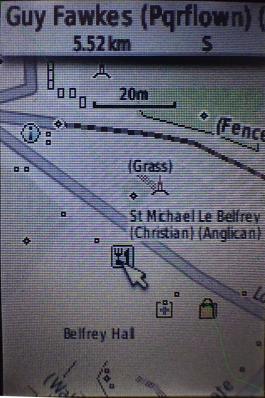
For many years I’ve used Garmin devices for both for navigation and for collecting data for OSM. As well as lots of premade maps in different styles it’s actually pretty easy to tinker with the map style yourself, although the OSM wiki makes it seem much more complicated than it actually is. It’s also pretty easy to see what OSM keys map to what values - there’s a file for points, one for lines and one for polygons that shows what OSM key and value corresponds to what Garmin feature.

I also maintain a web map style that tries to be much more inclusive than other web maps in terms of what it shows (have a look around the map legend for that), and thought that it’d be great to do the same for Garmin maps too. The web map style uses a lua script to preprocess OSM data before the CartoCSS code deals with it, which makes the latter much, much simpler. It turns out that exactly the same approach works when creating Garmin maps too, as described on this page.

See full entry

Location: 53.962, -1.083

Why are you mapping sidewalks as separate paths, rather than as tags on roadways?

While sidewalks as tags are adequate for many applications, they lack the ability to add detail to crossings and curbs. This information is vital for people who use visual and/or mobility aids. There is a project called OpenSidewalks which aims to bring equity to pedestrian data and provide routing tools for people whom have more specific mobility needs than what traditional routing tools can accommodate. Here is an excerpt from their mission:

Pedestrian pathways are critical infrastructure in urban environments that help people engage in their professional, community, and daily lives. To promote equitable urban growth, transit-oriented development, and resilient communities, we must give strategic, pedestrian-centric consideration to our sidewalks and pedestrian pathways, which are the dynamic connective tissue of our physical environments. Individuals experience the built environment in innumerable ways depending upon many factors, including their mobility. Therefore, their optimal path through the built environment is not necessarily the shortest or most direct route (despite the inherent Google Maps bias). Rather, their travel experience is influenced by static physical features, e.g., the availability of curb ramps and auditory signaling at crosswalks, as well as transient conditions (like precipitation). Automated routing applications can also make great use of this kind of data. For example, provided with such information, individuals prone to slipping on wet terrain could circumvent cobblestone sidewalk surfaces on rainy days, and individuals who require curb ramps can selectively identify routes that can accommodate their needs.

Additionally, much of Montréal already had sidewalks mapped as separate ways, and I am just expanding that coverage.

Guidelines

Sidewalks

Sidewalks should be:

See full entry

This text is a continuation of my previous diary and do what the title says. The draft already existed 6 months ago, but just today I’m publishing this diary. Anyway, there’s comment I head about this on the @Wikimaps telegram

“You seem to be doing what we were doing 10+ years ago before Wikidata existed” – Maarten Dammers opinion on what this approach doing

Well, he’s right… but there’s a reason for that. This diary have 4 parts, the examples are on 3.

1. Preface

This extension could be perceived as one approach to make general proposed data extraction from OpenStreetMap Wiki, which , in a ABox vs TBox dicotomy, is the closest of a TBox for OpenStreetMap (*).

*: if we ignore id-tagging-schema and, obviously, other custom strategies to explain the meaning of OpenStreetMap data, which could include cartocss used to explain how to render as image. I do have a rudimentary draft of try to make sense of all of her encodings here, but not ready for today.

1.1 Wikibase is not consensus even between what would be ontologists on OpenStreetMap

Tip: for those wanting to view/review some past discussions, check https://wiki.openstreetmap.org/wiki/User:Minh_Nguyen/Wikidata_discussions#Wikidata_link_in_wiki_infoboxes. The same page from Minh Nguyen has other links, such as discussions to remove the entire Wikibase extension from OSM.wiki at https://github.com/openstreetmap/operations/issues/764.

See full entry

Posted by NorthCrab on 24 July 2023 in Polish (Polski). Last updated on 15 August 2023.

🗺️🦀 Witam społeczność OpenStreetMap,

Z zadowoleniem ogłaszam mój najnowszy projekt, osm-budynki-orto-import - w pełni autonomiczne narzędzie do importu budynków, które obecnie funkcjonuje w Polsce. Jest to mój kolejny krok w kierunku uczynienia OpenStreetMap (OSM) bardziej dynamiczną i wydajną platformą.

Podgląd zbioru danych

Narzędzie to zostało zaprojektowane w celu uproszczenia i zwiększenia dokładności procesu importu budynków. System wykorzystuje oficjalne dane budynków w połączeniu ze zdjęciami ortofotograficznymi w celu weryfikacji poprawności danych przed ich zaimportowaniem.

Sercem tego projektu jest zaawansowany model wizji komputerowej, którego precyzja sięga 99,7%. Moim zdaniem dokładność ta przewyższa możliwości większości przeciętnych mapujących, zapewniając szybszy i bardziej niezawodny sposób mapowania struktur.

See full entry