OpenStreetMap logo OpenStreetMap

Users' Diaries

Recent diary entries

Posted by NorthCrab on 24 July 2023 in English. Last updated on 15 August 2023.

🗺️🦀 Hello to the OpenStreetMap community,

I am happy to announce my latest project, osm-budynki-orto-import — a fully autonomous building import tool currently in operation in Poland. This is my next step towards making OpenStreetMap (OSM) a more dynamic and efficient platform.

Dataset preview

This tool is designed with the objective of making building import process simpler and more accurate. The system utilizes official building data in conjunction with ortophoto imagery to validate the accuracy of the data before importing it.

At the heart of this tool lies an advanced computer vision model, with a precision as high as 99.7%. This accuracy is, in my opinion, superior to the capabilities of most average mappers, providing a faster and more reliable way of mapping structures.

See full entry

Posted by mapmeld on 23 July 2023 in English.

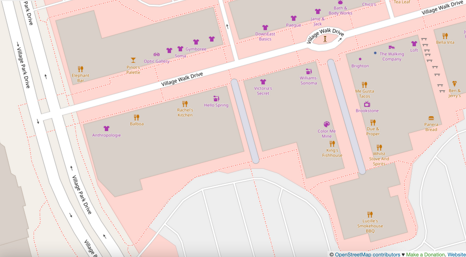
Last fall I posted about “Living Streets of OpenStreetMap US”. In Las Vegas, I encountered two pedestrian streets (tagged with highway=pedestrian), and they’re in an outdoor mall.

The next aisle over, by the Panera, is a walkable area tagged with benches but doesn’t have highway=pedestrian. I mapped a bike rack.
There’s also a splash pad on the map, which isn’t in any of the standard OSM renderers.

While visiting Moab, I corrected the new Utah Raptor state park to “Utahraptor”, and added two sculptures downtown (“Get Your Mind Rolling” was memorable).

I added some local businesses, parking access roads, residential access roads in a new development, etc. There are a good number of bike racks in national parks which ought to be mapped.

Shortly after I posted about bikes in northern Wisconsin / Lake Superior area, I found BicycleBenefits.org through the local co-op. Get discounts!

See full entry

Location: Moab, Grand County, Utah, 84532, United States

Como dito anteriormente, para as pessoas que estão interessados em aprender mais sobre o JOSM, gostaria de compartilhar alguns vídeos que registrei durante meus mapeamentos. Estes vídeos oferecem um pouco do meu processo e podem ajudar aqueles que são novos no JOSM ou que desejam aprimorar suas habilidades.

Aqui estão os links para os vídeos:

  1. Vídeo 1
  2. Vídeo 2
  3. Vídeo 3
  4. Vídeo 4
  5. Vídeo 5

Estes são apenas alguns exemplos do trabalho que tenho feito. A intenção é mostrar um pouco do processo de mapeamento e fornecer alguns recursos educacionais para a comunidade OpenStreetMap.

Além disso, em breve espero começar a publicar conteúdo adicional no meu blog, Balaio Cientifico. Fique de olho para mais atualizações!

Estou de Volta ao OpenStreetMap

Olá a todos,

Depois de uma longa pausa, estou finalmente de volta ao OpenStreetMap. Quero compartilhar algumas novidades que podem ter impacto significativo no modo como continuamos a mapear nosso mundo.

Aquisição de um Novo GPS

A primeira grande notícia que quero compartilhar é que finalmente consegui adquirir um GPS. Esse é um avanço enorme para mim, pois irá melhorar muito a precisão do mapeamento, especialmente nas regiões rurais.

  • Por que o GPS é tão importante?

Até então, contava principalmente com mapas baseados na web e imagens de satélite para realizar minhas contribuições. Embora estas sejam ferramentas úteis, têm limitações, especialmente quando se trata de áreas rurais, onde a cobertura do satélite pode não ser muito clara ou atualizada.

  • Quais são os benefícios?

Com um GPS, agora posso coletar dados no terreno, tornando as contribuições muito mais precisas e úteis. Seja uma trilha pouco conhecida, um ponto de referência ou uma estrada rural, posso garantir que esses recursos sejam representados com precisão no OpenStreetMap.

Projetos Futuros

A segunda grande notícia é que, apesar da pausa, minha paixão por mapeamento não diminuiu. Na verdade, ela só aumentou. Quero levar minha experiência e conhecimento a um público maior, ajudando a educar mais pessoas sobre o valor e a importância do OpenStreetMap.

  1. Blogging

Em breve, começarei a abordar mais sobre o OpenStreetMap no meu blog, Balaio Cientifico. Planejo compartilhar dicas úteis, truques, guias passo a passo e relatórios de experiências. Este será um ótimo recurso para novatos e veteranos do OpenStreetMap.

  1. Tutoriais

Além disso, tenho planos de criar tutoriais de vídeo, mostrando como maximizar o uso do OpenStreetMap e do GPS para criar os melhores mapas possíveis.

Eu já criei alguns vídeos no meu canal no youtube. Se você ainda não visitou, te convido a dar uma olhada.

Por hoje é só. Em breve eu volto escrevendo mais.

Если вам срочно нужны свежие карты для Organic Maps (OM), то:

  1. Выберите на https://extract.bbbike.org нужный вам регион
  2. Укажите почту, на которую вам придёт выгрузка
  3. Запросите выгрузку и дождись письма. Следить за статусом выгрузки можно здесь: https://download.bbbike.org/osm/extract/ В принципе, с этой страницы тоже можно скачать выгрузку
  4. Скачайте полученный архив и распакуйте его.
  5. Найдите на телефоне папку Android/data/app.organicmaps/files/<дата из шести цифр>/ Для iOS: подключите iPhone к макбуку->Finder->File Sharing найдите папку organicmaps
  6. Переместите в неё файл из архива заканчивающийся на .mwm
  7. Дайте ему имя вида: Russia_Lipetsk Oblast.mwm. Чтобы точно узнать имя файла сначала скачайте карту этого региона через OM. Запомните имя, удалите файл и переименуйте перемещённый файл

⚠️ Иногда карты могут быть не совместимы с последней версией OM. Тогда может помочь перемещение карт в папку карт прошлого месяца.

See full entry

Не забуваємо маркувати на карті археологічні пам’ятки(городища, стоянки, могильники). Історія, що лежить під земле також має значення.

Location: Семихатки, Білки, Білківська сільська громада, Хустський район, Закарпатська область, 90132, Україна
Posted by Z_Empty on 20 July 2023 in Chinese (China) (‪中文(中国大陆)‬). Last updated on 22 July 2023.

很早就看到了长沙周边丘陵山地已被绘制了不少,粗看还觉得绘图者做得很好,但从没有细看过。今日偶然放大查看长沙西部已被绘制“完成”的部分,才发现质量十分低下:

See full entry

Location: 桔子洲街道, 岳麓区, 湘江新区, 岳麓区, 长沙市, 湖南省, 中国
Posted by qeef on 18 July 2023 in English.

We have organized mapathons in Prague. We planned them, met on site, trained new mappers, mapped something and went to the pub. There we discussed and planned and exchanged our ideas. We called ourselves the core team. (I am only writing in the past tense because I am not there anymore; there is actually still a core team organizing mapathons in Prague.)

I was involved in Missing Maps CZ & SK from 2016 to 2020. I was involved in organizing mapathons. During that time I wrote and still maintain the mapathoner plugin. I like free software and I know that it is different from open source. I lobbed for openness. In 2020, I published Divide and map. Now. – the damn project and still maintain it. In 2022 I wrote simple hot intersecting areas and have not updated it since.

I am not sure if it’s time for this diary, but I want to write down my opinion about the core team and the community, because we have been talking about the community and the core team all along. And in my opinion, these two terms are often misunderstood.

DISCLAIMER: These are my own views. Please read this diary accordingly. I am in no way affiliated with OSMF, Missing Maps, HOT, MSF or the Red Cross.

Have you heard of WHAT, WHY, HOW and WHO questions? This is one of my favorite ways to discuss things.

Missing Maps’ WHAT and WHY are clear from their website. Let me put it another way: map the (vulnerable people of the) world because it’s a good thing. WHO is the community, the mappers. HOW is decided by the core team.

See full entry

Posted by b-unicycling on 18 July 2023 in English. Last updated on 3 August 2023.

I had added the odd sewer pipe using man_made=sewage_vent, because I had spotted some and was curious what they were. But someone in the Irish community had pointed out the under-documentation of man_made tags, so I did a bit of work, looked it up on wikidata and decided to go for man_made=sewer_vent instead. (I thought that man_made=sewer_ventilation_pipe was a bit long.) I retagged the existing ones which weren’t many anyway and added a few more from Wikimedia, especially in England, where many were covered by geograph.co.uk and one particular user (Rodhullandemu) especially. Sewer pipe on Regent Road By Phil Nash from Wikimedia Commons CC BY-SA 4.0, CC BY-SA 4.0 https://creativecommons.org/licenses/by-sa/4.0, via Wikimedia Commons

Some in Ireland and in England are listed monuments, believe it or not.

See full entry

Posted by pluton_od on 17 July 2023 in English.

I want to improve/update the lane information on the US highways where I traveled (maybe I’ll come back there one day and use OSM for navigation). The first one is US 6 in Utah, a part of the route between Salt Lake City and Moab, where great Arches and Canyonlands National Parks are. Bing aerial imagery is pretty good and recent in the US, so it’s pleasant to use. It’ll be an ongoing project in between other mapping.

What I’m mapping:

  • number of lanes, turn lanes, change lanes (near intersections), placement;
  • removing note:lanes where it’s now redundant;
  • turn restrictions including implicit ones;
  • connectivity relations inferred from road markings;
  • occasionally aligning the road to the Bing aerial photos.
Location: Sky View, Utah County, Utah, United States
Posted by b-unicycling on 17 July 2023 in English. Last updated on 31 July 2023.

I discovered an unrecorded shipwreck recently on Bing imagery, but because I don’t have the energy to put it all into words again, I’ll just copy and paste the press release I sent out today. It’ll be another chance to get the word out about OpenStreetMap.

I also made a video about it, but it’s a but all over the place, because I recorded, as the story developed, so it might be jumping around a bit. Sorry.

https://youtu.be/0gKV-SA1iNE

wikidata entry

Press release

Craft mapper discovers shipwreck after almost 100 years

Volunteer OpenStreetMap contributor Anne-Karoline Distel discovered a shipwreck on July 9th 2023 in the River Barrow. It was identified as the Tresness, a three-mast schooner which sank on August 21st 1929 on its way from New Ross to St. Mullins.

Anne had been mapping along the River Barrow using newly released Bing satellite imagery, when she discovered the wreck which is about 25m long and clearly visible on the imagery, possibly because the photographs were taken at low tide. After consulting with underwater archaeologist Jimmy Lenehan, she reported the discovery to Karl Brady at the Underwater Archaeology Department of the National Monument Service. Karl was able to identify the ship; it had made the news in the Irish Independent, the Northern Whig and Belfast Post and many other newspapers at the time.

See full entry

Location: New Ross Rural ED, New Ross Municipal District, The Municipal District of New Ross, County Wexford, Leinster, Ireland

THE BEGINNING: Let’s do a reunion in Kosovo! That was my first reaction when I was first introduced to the idea of FOSS4G conference last year (when I was still in New Zealand) by our host Gresa Neziri, one of the main persons at the event, and a dear friend. Luka and Slavica, my two other Balkan friends were also joining. Exciting! Although, I have moved away from spatial data analysis for my research, the opportunity to reconnect with old friends from ITC, Netherlands and potentially connect my research on disasters and ethics with spatial planning was an opportunity I did not want to miss.

See full entry

Location: Främre Luthagen, Fjärdingen, Uppsala, Uppsala kommun, Uppsala County, 753 13, Sweden

Привет всем! в перспективе, всем беспилотным системам придется это учитывать, однако, и сейчас есть актуальность. давайте создадим бесплатный слой дорожной разметки и знаков! по ним потом будут ее наносить повторно, не дадим монополизировать эту информацию…

Location: Полесский, Московский район, Брест, Брестская область, 224012, Беларусь

A virtual discussion on the subject “The Sustainability of OpenStreetMap Communities” held on July 4th, 2023 was the sixth of the Humanitarian OpenStreetMap Team (HOT) Community Working Group Peer-to-Peer Learning Series aimed at supporting the new OSM chapters in Saint Lucia and Dominica. What follows are some key takeaways from that discussion.

The session got underway with an icebreaker of sorts where participants were asked to give one word that could be used to describe a sustainable OpenStreetMap community. The question garnered 19 responses, including: inclusive, resilient, accessible, accountable, self-sustained, and active.

What are the potential challenges or barriers to sustaining an OSM community?

The question received about 21 responses. Lack of resources was a commonly repeated theme, with the key resource being financial.

Other challenges highlighted include a lack of motivation and the inability to replace leaving members. It was noted that language differences can also be a factor.

Additionally, there were personal testimonies of challenges, for example, Covid 19 stopped in-person meetings for OSM Kenya forcing online meetings, which hindered some of the members.

What funding models or strategies can be implemented to ensure the long-term sustainability of an OSM Community?

This question was particularly relevant coming off of identifying the lack of financial resources as a prevalent challenge to the sustainability of an OSM community. Again 21 responses were generated.

Membership fees were raised as an avenue for fundraising, but some felt that it might be counterintuitive as it may scare away would-be members.

A key source of possible funding is grants from the OSM foundation, although it was more typical for newly forming communities.

The groups’ earning potential was also discussed, for instance maybe the community should be allowed to take up a funded project or use the varied skill sets within the group for earning finances.

See full entry

Location: Jetrine, Laborie, LC11 101, Saint Lucia