Users' Diaries

Recent diary entries

Posted by @Garam on 6 February 2023 in Korean (한국어).

오래간만에 왔더니 사람이 많이 늘어난 것이 눈에 띕니다.

예전에는 한국어 일기는 혼자만 작성했었고 한창 포켓몬고가 유행하던 때에는 동네에 포켓스톱을 만들어 달라는 글이 간혹 올라오던 곳이었는데 활발해진 게 보기 좋고 더불어 과거에 서양 중심적인 툴 내에서 제가 하던 고민들도 여럿 보이네요.

한국 지역의 태그와 관련해서 과거에 정리했던 위키 문서가 묻혀 있는 듯하여 다시 올려 놓습니다. osm.wiki/Korea_tagging

오늘도 즐거운 편집 되시기 바랍니다.

Posted by watmildon on 6 February 2023 in English. Last updated on 8 February 2023.

About me

A photograph of the mountains near Gold Bar Washington. A range of rocky peaks are in the distance with nearer hills covered in green trees. A river winds it's way through the middle of the photo

I started mapping in June 2020 as a way to find parks and trails near my home in Redmond, Washington. My daughter loves adventures and provides huge motivation. I am a software engineer by trade and from that bring my passion for great tools. I love being able to work with others on a project that is expansive, vivid, and important.

My mapping

See full entry

Hello and thank you for reading why I’m interested in continuing my service on the OpenStreetMap U.S. board for one more term!

This organization, under the excellent leadership of Maggie Cawley, has been making great strides in supporting our community and open geospatial data. I have been involved in a number of these efforts and would love to have one more appointment to follow through on these projects and help steer OSM U.S. on its path.

Specifically, I’ve been leading the Trails Working Group, a collaboration of OSM mappers, data users and land managers, towards building a better system for trail data that protects our environment and keeps people safe and informed. The Trails Stewardship Initiative is a project I’m passionate about. I am excited to see where it leads OSM U.S. in cooperating with entities that use our data. I am also highly interested in academic connections, such as the opportunity we had to work with data science students at the University of Virginia to help build a tool that will identify where the map is underrepresented. I am also part of the TeachOSM Education Working Group, which is focused on building materials that help teachers bring OSM to their students. OpenHistoricalMap is another space where I see immense growth potential for connections to students given all the data that can be created on that platform.

In last year’s election cycle, I mentioned the following priorities for building connections in the OSM U.S. community and they still hold true:

  1. Education Connections – expanding the awareness of OSM among students as something to which they can contribute as well as use as a data source
  2. Community Connections – encouraging local groups to engage in OSM to help address their community needs
  3. Professional Connections – opening communication with government entities to create symbiotic relationships with OSM

See full entry

Начал записывать углублённый курс лекций по JOSM. Для начала выпустил три большие лекции по работе с геометрическими объектами в редакторе JOSM.

1) JOSM. Лекция по работе с геометрией объектов, часть 1 [1ч45мин] https://www.youtube.com/watch?v=TGDZWOhPEAs

  • Типы геометрических объектов OSM
  • Режимы рисования
  • Сходство и отличия разных режимов рисования
  • Способы выделения объектов (массово, поштучно, перечнем, поиском), которые предоставляются базовым JOSM и плагином Utilsplugin2
  • Инструменты рисования, которые предоставляются базовым JOSM, а так же плагинами Fastdraw, Building Tools и Improve Way.

2) JOSM. Лекция по работе с геометрией объектов, часть 2 [1ч11мин] https://www.youtube.com/watch?v=xxWha-FcqZc

  • Разрезание линии сразу в нескольких местах
  • Разрезание замкнутых линий (почему требуется не меньше двух точек, можно ли обойти этот запрет и для чего он нужен)
  • Рисование кругов по двум точкам, по трём, рисование дуг по трём точкам. (И почему сегментов у круга получается именно столько, а не иначе, как сделать если хочется больше/меньше.)
  • Добавление промежуточных точек на существующие фигуры без изменения их формы.
  • Добавление точки перекрестка на пересечение двух линий (и для чего это нужно)
  • Несколько дополнительных возможностей плагина Building Tools
  • “Замена геометрии” и опасность этого инструмента
  • Два инструмента для лоскутного зонирования без мультиполигонов (и для чего такое может понадобиться).

3) JOSM. Инструмент Поиск со сложными запросами [26мин] https://www.youtube.com/watch?v=9E9yea1FuTs

  • Как работать с инструментом Поиск на примере “ищем в городе все подъезды многоэтажек, для которых не указан диапазон квартир”.
  • Как работать с инструментом Фильтр, используя запрос, сконструированный при помощи инструмента Поиск.

See full entry

Posted by hdevine825 on 5 February 2023 in English.

I’m Harrison Devine, and I am running for the OpenStreetMap US board. I edit on OSM and OHM as hdevine825. I have come to OSM through a confluence of my love of maps and open projects.

I got my first start in OSM contributing a few changesets to a HOT project in 2014. I never engaged with the community during this brief stint, and I think that is one reason I did not get more involved. Fast forward to 2021, in the midst of the pandemic, I dove into editing Wikipedia. As I got into Wikipedia, I discovered a passion for cataloging information and contributing to open projects. Then in late 2021 I got back into editing OSM and quickly got involved with the local mapping community.

I’m located in Brooklyn, NY where the map is already densely populated. That has led me to mapping smaller details of sidewalks, tactile paving on curbs, and benches in parks. My largest contributions have been in mapping sidewalks around Brooklyn. I also work on welcoming new mappers and connecting them to the community through the OSM US Slack and giving feedback and resources for their mapping.

Professionally, I work in non-profit accounting. In this role, I work with multiple organizations overseeing their finance function. Often I am the person presenting financial statements to the non-profits’ boards. This has given me considerable experience with compliance and best practices that I hope to contribute to OSM US.

See full entry

Posted by LegzDev on 4 February 2023 in Spanish (Español). Last updated on 5 February 2023.

Educacion primaria y secundaria básica:

Circulo infantil, Jardin de niños (0 a 5 años):

Primaria (Preescolar a 6to grado):

Secundaria Básica (7mo a 9no grado):

After having been involved with the organization of the last few global State of the Map (SotM) conferences, I recently got asked if I could provide some information about the technical side of how hybrid events work to one of the organizers of a future local SotM conference. While writing down some of these details, I figured that this might be of general interest, hence this diary post which also contains various aspects about hybrid events based on our hybrid SotM 2022.

The post will try to cover the last three global SotMs and thus not only technical aspects of a hybrid conference: SotM 2020 was originally planned to take place in Cape Town, South Africa, but had to be moved to a purely online format for well-known reasons. Still for the same reasons, SotM 2021 was planned as an online conference from the beginning. And finally, SotM 2022 in Firenze was our first hybrid conference.

Please note that all views, opinions and experiences expressed in this post are mine and not necessarily shared by the SotM Organizing Committee or other SotM Organizing Committee members. The post is also mostly based on my personal memory only, so I certainly missed or wasn’t aware of many aspects and details, especially in all the areas where I wasn’t involved at all. It also concentrates on the technical side of things and how we did them, not so much on e.g. more social aspects or why we did something in the specific way we did it.

Organization and planning

See full entry

Following the Global State of the Map in Italy, the Inaugural State of the Map Nigeria came to be this time with Mr Victor Sunday as the Chair.

The conference was organized by Unique Mappers Network Team and saw attendees from various states of Nigeria, from Hong Kong, Tanzania, Brazil, Zimbabwe just to mention a few. I was in for Quality Assurance and Volunteer Lead alongside Kaue de Moraes Vestena. It was great learning especially from the Nigerian Community how they are using FOSS, contributing to OSM and all. It was an honor launching this hybrid conference and paving way for many to come.

My gratitude goes to Mr Victor Sunday for also trusting my capability in this, the Unique Mappers Team at large and to the Humanitarian OpenStreetMap Team (HOT unSummit) for sponsoring me. So Mr Victor asked me again to give closing remarks like I did in Italy, if it’s now a calling I don’t even know. I am thrilled to be part of the Unique Mappers Network as an Intern – this also adds to the space. I am more than grateful.

Posted by pedrito1414 on 2 February 2023 in English.

Sharing with you again some of the things that Ruben and I have been excited about, and some of what’s coming up, in the HOT community and across the humanitarian open mapping movement.

Things that have excited us this week…

Congrats to the HOT training working group who had an impressive 52 participants at the advanced JOSM training last weekend!

Chisom Okwuchi shared a lovely OSM diary of her experiences as a Community Working Group mentorship lead

… and, the organising group for the mentorship program is now planning for the next phase and will be looking for mentors and mentees in the next few months!

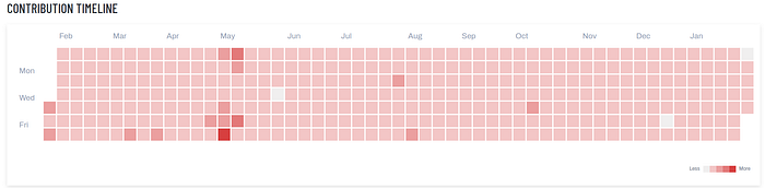
Shout out to Kraan46, one of HOT’s global validators, who has now validated on 360 days out of the last year — an impressive feat and huge contribution!

Contribution timeline for Kraan46

Contribution timeline for Kraan46!

Kudos to OSM Uganda, who have established a new MOU with the Terego district on integrating OSM learning into schools.

See full entry

Posted by Jemimah Mukisa on 2 February 2023 in English. Last updated on 3 February 2023.

Upon getting the news of being awarded a scholarship to attend and participate in the State of the Map Tanzania 2023, I was so excited to travel since it was my first time to visit Tanzania. I thank God that I made it to the conference which commenced on the 20th-23rd of January.

My highlights from the first day were from the Resilience Academy I was amazed by the tremendous work they do to impact the society through collaboration and partnerships to train young people with skills and knowledge to achieve the country’s sustainable development goals. My evening was sparked when I toured around the neighborhood I noticed that the transport system was properly planned with easy access and convenience.

The lightning talks were very insightful as people shared their experiences in OpenStreetMap and how they have been able to grow their communities. I realized that Tanzania has a wide network of mappers whereby they have established and promoted youth mapping chapters within their universities as compared to my country therefore I learned that more effort to grow our community here in Uganda is key in order to achieve the designed goals for the country with the use of OpenStreetMap.

I got a chance to participate in the Advanced QGIS training with the trainers Ian Coady and Steve Penson who did an amazing job teaching us the course exhaustively. I learnt a lot and I plan to use the knowledge to advance in my career. I was also given an opportunity to present the application of photomapping in OpenStreetMap with the use of Mapillary. https://youtu.be/OgoRLDUNhHQ

Meeting the Geochicas (women in Geospatial) was enlightening, we got to share experiences and the way forward to expand the number of women in this sector. The conference gathered many people from different parts of the world. Interacting and engaging with them broadened my thinking scope from their experiences in OpenStreetMap and beyond. I made so many friends and am grateful for having them join my network.

See full entry

Location: University Residential Houses, Kijitonyama, Kinondoni Municipal, Dar es-Salaam, Coastal Zone, 25195, Tanzania
Posted by ElvioMendes on 1 February 2023 in English.

I am looking for a way of making an API call and obtain a list of routes that started within a given location and ended within a given location:

Inputs or columns from data table

Input variable the departure place: Lat range and Long range Input variable for arrival place: Lat range and Long range Input variable (range) for the duration of the trip Filtering per vehicle type, avoid certain routes per multiple variables….. Timespan for the search (data start and date end).

Output:

List of all the trips existing for the above, including :

date and times polyline format if possible Name of roads, turn left/right Speeds on the streets (optional)

Does anyone know if at all possible?

Location: Penge, London Borough of Bromley, Greater London, England, SE20 7TN, United Kingdom

Recently I found Streamlit which is a pretty cool Python library that makes it easy to create web apps for visualising data.

I converted changeset dump from planet.osm.org to Parquet file format and uploaded it to AWS S3 storage. Then created this streamlit app in their free cloud: https://ttomasz-tt-osm-changeset-analyzer-main-apdkpy.streamlit.app/ which displays some basic statistics.

The app leverages the power of DuckDB, a database engine that can query these files over internet on demand. Parquet files, which are a popular format in modern cloud data lakes, have several advantages over traditional file formats. They are column-oriented, compressed, and support range requests, which means that you can download only the portion of the file you need, instead of having to go through the entire file, making processing larger datasets much faster.

DuckDB works similarly to SQLite in that it doesn’t have a dedicated server. You run the queries locally [0]. This makes the setup super simple you either install the binary or configure connection in IDE like DBeaver and you can run SQL queries.

Running these simple SQL queries over remote Parquet files takes about a minute or two. Trying to do the same with a custom script on raw changesets.xml.bz2 file would run longer not to mention that the effort to prepare the code would be much much larger.

It would be great if OSM hosted more “consumption ready” data instead of relying on users to do their own coding and parsing.

Let me know if you have some ideas for charts/tables that could be added to the demo.

[0] - well in this case they are running on streamlit cloud’s server but you can run the queries locally on the same parquet files easily

Posted by DeLouredo on 30 January 2023 in Galician (Galego).

O actual cruceiro da Alfarrapa é contemporáneo do situado no cruce de Refexón co Tabolado. O seu autor foi don Juan Míguez Domínguez. Anterior a eles é o do barrio da Torre. Os tres compóñense de pedestal, fuste octogonal e cruz. Non teñen imaxes.

O anterior cruceiro que aquí estaba caeu por mor dun carro que chocou con el, segundo unha versión. O párroco, don Esteban Viso, decidíu poñer os restos no muro da súa viña, ben visibles, e restauralo. Nunca pasou tal. Levantouse un novo cruceiro, por obra e desexo de don Juan Míguez (mesmo autor que o do Tabolado). Os restos están ben visibles no muro da antiga viña de don Esteban, no Pireiro, enfronte dun cruce de camiños, así que poden visitarse e fotografar con toda facilidade.

Location: Casa Grande da Granxa, A Telleira, Soutelo, Rabiño, Cortegada, O Ribeiro, Ourense, Galicia, 32200, España