 OpenStreetMap

I have contributed to open street map using mapswipe as a member of Oyo mappers team
Users' Diaries
Recent diary entries
I have contributed using map swipe as a member of Oyo mappers team
I have mapped using mapswipe as a member of Oyo team
I have mapped using mapswipe as as a member of oyo member team
I have mapped using mapswipe as a member of oyo mappers team
I’m no stranger to GIS, so I jumped right in. Filled in BLM routes around Painted Gorge, Mica Gem, and Buck Canyon. Cleaned up some routes at Valley of the Moon and along Grapevine Canyon.
Still need to add a couple routes to Painted Gorge but I want GPS data first. There are discrepancies between BLM maps and aerial photos that can only be resolved by going there in person.
The Yuha Basin is also on my to do list, but I definitely want GPS data for that first. The BLM map isn’t that great and there are a lot of tracks on the ground that differ from the map.

After a summer break here we are. We just got over 5000 Table Tennis Tables in Switzerland. Here is the [TagInfo]{https://taginfo.osm.ch/tags/sport=table_tennis#chronology} We can expect another boost the next days because I have an agreement with my neighbour driving pingpongtische.ch, that we can use his database to find yet unmapped tables in OSM. We would not just import these, but scroll through them and check if we can verify their positions with the Swisstopos SwissIMAGE.
So for the next 1000… :-)
%20by%20Vince%20Emond.jpg)
Hi all,
Many people have been asking me over the last year what technology HOT is working on, what’s on the cards for the future and where we are headed. Given my role, all good questions I want to answer. The good news is, I have some of the answers and would like to share them with everyone for feedback, ideas or inputs as you feel compelled.
Sharing here for community comments hot_tech’s t21 basemap. This document outlines what underpins our future direction, decisions and deliverables.
For those that don’t want to read the whole thing, as the elevator pitch reads, the heart of our mission lies here:
By redirecting resources to augment and amplify the efforts of others, the future of hot_tech will no longer be focused on building technology for open mapping collectives, but instead building technology with them.
While I recognise this doc may not answer all questions and possibly raise even more, we see this as the starting point, our nodes and ways, our building=yes from which we can start to add more depth.
For those that just want the short version, I have summarised all the key changes in our ‘right turn document’, which clearly outlines not only what we plan to do, but also how we plan to do it.
Like it says at the end of the doc ’The closing of this document marks the opening of the conversation’, so I look forward to having this conversation with our entire collective of hot_tech supporters, stakeholders, contributors and users.
Kindness,
Bo

Dear all,
Today, v5.4.0 of the OpenStreetMap Carto stylesheet (the default stylesheet on the OSM website) has been released. Once changes are deployed on the openstreetmap.org it will take couple of days before all tiles show the new rendering.
Changes include
- Added a new
planet_osm_line_labelindex (#4381) - Updated Docker development setup to use offical PostGIS images (#4294)
- Fixed endline conversion issues with python setup scripts on Windows (#4330)
- Added detailed rendering of golf courses (#4381, #4467)
- De-emphasized street-side parking (#4301)
- Changed subway stations to start text rendering at z15 (#4392)
- Updated road shield generation scripts to Python 3 (#4453)
- Updated external data loading script to support pyscopg2 2.9.1 (#4451)
- Stopped displaying tourism=information with unknown information values
- Switched the Natural Earth URL to point at its new location (#4466)
- Added more logging to the external data loading script (#4472)
Thanks to all the contributors for this release including ZeLonewolf, kolgza, and map-per, new contributors
For a full list of commits, see https://github.com/gravitystorm/openstreetmap-carto/compare/v5.3.1…v5.4.0
As always, we welcome any bug reports at https://github.com/gravitystorm/openstreetmap-carto/issues
Introduction
Later today (September 22, 2021) OpenStreetMap US is hosting a discussion on trail tagging. There has been a lot of chatter recently about how to map these, and the following summarizes my current thoughts on the matter going into tonight’s meeting. I wrote these up mainly as a way to organize my own thoughts, and I’m sure that my opinions will change after further discussion.
Definitions
A path is any way not meant for wheeled motor vehicles. A trail is path or other way signposted or recommended by the landowner for use by those who are not in wheeled motor vehicles. Paths are mapped as ways, and trails are mapped as relations.
Paths that do not exist and never existed
These paths should be removed from OSM. If remote mappers keep restoring them, it may be worthwhile to leave the line tagged with only a note.
Paths that do not exist but recently used to exist
These paths should be tagged with abandoned:highway=path where found, but ideally they should not have been added in the first place. If these paths are deleted, from my experience, locals will inevitably add them back.
Paths that exist but should not exist according to the landowner
Tag as highway=path + access=no + informal=yes where found, but ideally they should not have been added in the first place. There are arguments to be made for using a different tag than path, but none exists as of yet. Deleting these from OSM is futile as locals or remote mappers will inevitably add them back.
Paths that exist and are only to be used by the landowner and guests
Tag as highway=path + access=private where found, but ideally they should not have been added in the first place.
Paths that exist and are tolerated
Tag as highway=path + access=permissive + informal=yes.
Paths that exist and are authorized
Tag as highway=path and include a surface tag
Paths that are part of trails
Tag as highway=path + surface=* and include in a type=route relation
Posted by googlenaut on 22 September 2021 in English.
Last updated on 27 September 2021.
how do you make those 3d-models, especially the more complex structures? .. here’s my reply.
Well, it’s an ambitious task to to it but it isn’t so superhard as it seems. The main difficulty is to get hi-res satellite imagery and some information on building levels and height. Another difficulty comes from the blind modelling approach in JOSM. You can get some help from the Kendzi3d Plugin, but I don’t make use of it. So it’s always a little surprise what the rendering engines does with the uploaded changeset. I’m not a big fan of commercial F4mapDemo with its animated objects. I prefer to see good results on OSMbuildings and OSMgo
I usually start with a floorplan, which could be found on wikipedia or other building related websites. You can resize it to match your favourite scale. When it comes to building parts i make use of the building symmetry. The roof shapes could be estimated from the hi-res satellite imagery. But there’s no height information apart from the shaddow length. So if there’s nothing on wikipedia, emporis, streetview or other, I use some photogrammetry tricks to get the information I need. I often combine some simple structures to achive a higher complexity. But I try to keep it as simple as possible. I also avoid to use multi-polygons, cause their roof will never be rendered the way I want it. Finally i check that all parts won’t overlap with the building outline and put everything in a single building relation. That’s it.
Editado San Carlos y Quillon usando fuentes de la INE

Hi all,
Here’s my response to the question listed on wiki page for the board election.
osm.wiki/Humanitarian_OSM_Team/Board_Elections_2021
Please feel free to comment or message/mail me, talk to you soon!
By Arnalie Vicario
Q1. What is/are the impact/s of the shift from global to regional structure of HOT on voting members?
A1. Strengthen the regional/local community is good in many ways including reducing the language barrier and harmonizing the open culture to local. Voting member is usually the opinion leader of local/regional community. As a result, about the impact of the shift from global to regional structure, it could be good to HOT.
Q2. Conversely, how do you think the voting members should interact (e.g. what is their role) with the Regional Hubs?
A2. Regional hubs can assist the voting members and the local communities to work more aligned to the vision/mission of HOT. The active voting members may talk with regional hubs more often for the harmonization of local/personal interests and HOT objectives.
By Matt Gibb
Q3. How can we support HOT volunteers who may experience burnout as we work towards HOT’s Audacious goals (including Voting Member and non-Voting Member volunteers), while the number of HOT paid staff grows?
A3. Burnout in community happens, so the responsibility of paid staff is getting heavier. We should facilitate more communications so we “speak out before burnout”. We also could take turns (flying geese paradigm) to be responsible for the tasks towards HOT’s audacious goals that potentially burnout community members.
By Heather Leson
Q4. What are the most important things the HOT board should be doing for the 1. membership 2. board 3. staff 4. global OSM community?
A4. (1) to facilitate the friendly (in many ways) environment for our community members. (2) be the plus to the operation of HOT. (3) share the experience and expertise. (4) be more influential in global community.
Posted by SmartFinn on 20 September 2021 in Russian (Русский).
Last updated on 23 September 2021.

В чем сложность
После смещения основных дорог к откорректированным снимкам (причины описаны тут Исправляем Угледар), пришла очередь править здания. Принцип правки зданий по спутниковым снимкам довольно простой, ничем не отличается от добавления новых, сначала смещаем контур на крышу нужного дома, правим, потом переносим контур на фундамент этого строения. И уже здесь начинаются первые проблемы, и чем больше этажность — тем больше проблем.
Большинство зданий окружено деревьями, повезет если будет виден хотя бы один угол дома у земли, но зачастую нет и этого. Но хуже всего дела обстоят с дорогами ведущих к подъездам, особенно если они находятся к востоку и к северу от зданий, их скрывают не только деревья, а и сами дома.
Как рисовать в таких условиях
Из описаного выше следует что полагаться только на подложку в виде аэроснимков не получится. Ситуацию могли б исправить панорамы улиц, но такого для Угледара не подвезли. Фотографий на Google Maps и Mapillary либо просто нет, либо они не дают достаточную картину.
К счастью доступен вариант по-лучше, а именно Генеральний план міста Вугледар 2019 года.
Чтобы превратить это в инструмент возьмем файл ГП_схема вулично-дорожньої мережі.pdf, как более близкое к тому что нам нужно, сконвертируем его в PNG (gp_vugledar.png) . Далее, с помощью плагина PicLayer для JOSM, превратим полученный файл в подложку и и откалибруем (gp_vugledar.png.cal).
После чего задача становится тривиальной. По снимкам Maxar Premium Imagery (Beta), как более свежие и четкие снимки этого региона, корректируем контуры зданий, после чего включаем слой с Генеральным планом г. Угледар и переносим контур на соответствующее место. С дорогами все еще проще, рисуем по вверх генплана, оглядываясь на Maxar.
Все объекты в Угледаре, у которых есть тег source=ГП_схема вулично-дорожньої мережі.pdf; Maxar, нанесены именно таким способом.
Полезные ссылки

what is this about?
this entry describes a possible workflow for identifying missing road segments, thanks to the standard low-res Strava heat map. you may also use it to reclassify all those ‘highway=track’ that so many remote mappers keep creating for our ‘surface=unpaved’ unclassified and tertiary roads.
the mapping practice here described is totally manual, and quite obviously its speed will be inversely proportional to the precision you want to achieve.
preparation steps
- install JOSM
- in JOSM, activate the low resolution Strava heat layer
- do that by editing the Imagery Preferences settings,
- look for Strava among the available default entries,
- select the cycling and running heat map,
- activate it.
- you will need to restart JOSM after activating the new imagery layer source.
typical editing session
prepare for mapping
- add the OpenStreetMap (Carto) Standard layer,
- roughly choose an area of interest,
- add the Strava heatmap layer, but do change its transparency to 50%,
- add your favourite Aerial photography layer (here I will be using Bing because I will show screenshots and the Bing license allows didactic and instructional use. in mapping I tend to prefer Maxar.)
- order the layers so that:
3: is Strava, on top of both:
2: your favourite aerial photography layer,
1: the Carto standard map,
identify a missing road
Posted by Yarik32 on 19 September 2021 in Ukrainian (Українська).

Дисклеймер: зміни, які я вносив для того, щоб створити мем, не були завантажені у OSM. Прошу тих, хто вирішить скористатися цим гайдом, також утриматися від завантаження мемів у OSM
У кінці 2018 року гуглокарту (тьфу) заполонили школи, парки, усе назване на честь Рікардо Мілоса. Через деякий час усе виправили, а псувати їхню мапу під меми стало набагато складніше. Із свідчень очевидців (мене тоді ще не було в OSM), нам досталось не так сильно. Але хотілося б похайпувати на мемах, де в куточку гордо написано © OpenStreetMap contributors. Тому я вирішив створити гайд по створенню мемів на основі даних OSM.
Я намагався написати його так, щоб було хоч трохи зрозуміло тим, хто вперше дізнався про OSM, тому для тих, хто мапить і, тим більше, використовує його дані, тут усе й так буде зрозуміло.
Власне для обробки даних OSM я пропоную використовувати QGIS, бо інших ГІС не досліджував.
➕/➖ описаного мною методу:
➕ Використовує дані OSM;
➕ Дозволяє максимально змінювати вигляд мапи
➕ Дозволяє змінювати дуже великі об’єкти, міста, області
➖ QGIS має підвищенний поріг входження
➖ Вимагає багато часу
➖ Потрібен комп’ютер (мабуть)
Скачування географічних даних
OSM містить дані про безліч видів об’єктів. Але якщо нанести на мапу абсолютно все, то вона виглядатиме як чорний прямокутник. Тому ми візьмемо лише найнеобхідніше: будинки (building), використання земельних ділянок (landuse, natural), дороги (highway) та річки, озера (waterway, natural).

Hey everyone, I would like to have a mapper meetup sometime. I am loving OpenStreetMap and would like to meet with other mappers in the region.
Posted by SomeoneElse on 18 September 2021 in English.
I’ve added a new page to the switch2osm guide: “Manually building a tile server (Ubuntu 21.04)”. The work that the Debian developers have done to include the required software inside Debian 11 is now in Ubuntu 21.04, so there’s actually less setup work needed than in previous Ubuntu versions.
Ubuntu 21.04 isn’t an LTS release, so Debian 11 or Ubuntu 20.04 are still the recommended options for servers that are expected to stay around for a while. One of the regular faux pas with the Natural Earth download site has just been and gone, but the guide includes a workaround in case problems reoccur there.
唐山地区(路南区、路北区、古冶区、开平区、丰润区、丰南区、曹妃甸区、迁安市、遵化市、滦州市、迁西县、玉田县、滦南县、乐亭县、芦台经济开发区、汉沽管理区)现在有多位本地居民在OSM中对唐山地区的道路、公园、住宅区、公交线路等信息进行更新和维护,希望外地人特别是外国人不要凭借个人的想法对我们已经确认并绘制完成的正确内容进行修改或删除。 唐山地区的道路,国道标记为主干道路(trunk),省道标记为主要道路(primary),县道标记为二级道路(secondary),乡道标记为三级道路(tertiary)。以上同样适用于全中国。 我发现刚有人将唐山沿海两区县的道路给更改、删除了,比如将宽大的省道、主路改成住宅区道路、因为卫星地图老就把已经确认修建好的道路删除了……我怀疑是外国人干的,因为中国的mapper应该都知道国道、省道是怎么什么吧。 我们这些唐山本地mapper所绘制的信息都是我们本人经常接触的、居住地附近的、去过的地方,以及从新闻里看过的、政府官网发布的、规划图里定好的、电子地图里能看见的。 唐山地区的地图怎么画,我们都是有共识的,有问题我们会自己修正,希望外地特别是外国的绘制者(如果没有足够的把握)不要大范围乱动,尤其是道路信息等级。 希望我说的那个外国人不要在全国范围内乱改中国的国、省、县、乡道了。

Début de l’aventure ici
Ça y est !
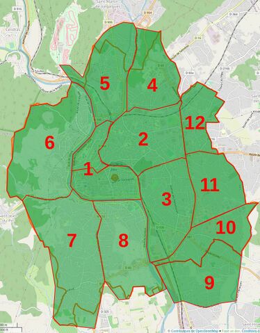
Le projet d’adressage est terminé. Cela aura été beaucoup plus long que prévu avec un gros coup de mou sur les parties 6 et 7. J’avais commencé par le centre ville qui, s’il est très dense en numéros fut très rapide à traiter (peu de bâti à mettre à jour, voies correctement renseignées et incrémentation des adresses de 2 en 2). Comme c’était le début, ça a été mon référentiel pour établir les zones. Malheureusement, les zones hyper urbanisées et rurales sont très différentes à traiter. Dès que l’on arrive dans les quartiers semi-ruraux, v’là la galère :