
Walking around and adding new objects to OSM helps to get to know the area a lot.
At the moment, I’m adding only street names and house numbers. Adding roads or deleting some, because my area is relatively new and things change here fast.
 OpenStreetMap
Walking around and adding new objects to OSM helps to get to know the area a lot.
At the moment, I’m adding only street names and house numbers. Adding roads or deleting some, because my area is relatively new and things change here fast.
临港大发展 洪庙大振兴
tldr; hot_tech is running the second round of an ai-assisted mapping study
Call to action: please sign up to participate or share with your networks
time: read: 5m | sign-up: 5m
best before: Sept 17th, 2021
Hi all!
As some of you may remember, earlier this year HOT undertook an experiment to compare tradiational mapping with AI-Assisted mapping. After the first round of results have been gathered (soon to be released), hot_tech will be undertaking round two (Sept 17th, 2021) and we are looking for beginner mappers (<50 changesets) to join the study.
The experiment is designed to compare the results of traditional remote mapping workflows (editing in ID Editor) with emerging AI assisted workflows (editing with RapID). To do this, we will be conducting mapping experiments of two locations (Uganda and US), with beginner mappers (<50 changesets) using the two different remote mapping workflows (RapID and ID).
On Sept 17th, 2021, we will run one mapathon of 90 minutes, with participants being randomly assigned - prior to beginning mapping - to map building footprints with either ID or RapID. Data will be gathered on the existence of map features in two locations (US and Uganda) from which we will compare the completeness of mapped features and similarity of map features when compared with an OSM reference dataset.
For the mapathons we will be using convenience sampling from our networks by generating a public call for participants.
A couple of specific asks, please email if:
_ You would like to be involved in any capacity (organising, recruiting, sharing, supporting, please shoot me an email)
_ You would like to support the mapathons specifically, that would be great
_ You would like to participate in the mapathons please please sign up to participate HERE »
Thanks all, I hope everyone is safe and well and looking forward to exploring this with you all soon.
Kindness,
bo
Street I live on.
From the OSM wiki Key:name
I’m currently tidying up a couple of loose ends in preparation for the release of version 16 of Vespucci. One of those dangling bits was supporting the new format of the name-suggestion-index (NSI).
The NSI was conceived back in 2013 by Aaron Lidman as a list of canonical name spellings for chains of stores, restaurants and other similar facilities, most notably for use in iD. Vespucci has supported use of the NSI nearly since day one, see a diary post from 2014 (this works quite differently in current Vespucci versions). Since then it has morphed to a, supposedly, authoritative source of tagging for a very wide range of objects. Some would say that the current version has expanded its reach far beyond what is actually useful (flagpoles ffs), but that is not the topic of this post.
Prior to the release of iD 2.20 the NSI had been in a long period of stasis with updates being made to the data, but these were not actually being deployed and given the larger format changes I had all but forgotten about it and the data in Vespucci was really old. However over the last couple of months some colleagues pointed out some weird behavior in Vespucci and iD when using NSI generated presets for tagging. In particular name tags are being added to things like excrement bag dispensers and automated postal package depots.
Como já falando no texto anterior o OpenStreetMap não é tão amigável com o usuário comum mas serve muito bem para os cartógrafos, também recebi muitos comentários que o OSM não é um produto final e sim uma base de conhecimento compartilhada e até algumas comparações com linux… Mas usar o OSM não deveria ser difícil ou depender do rebrand de grandes empresas, acredito que tem como atingir o usuário comum e ganhar mercado e sendo opensource e ainda trazer mais mapeadores para a comunidade.
A alguns venho trabalhando no que seria um cliente ideal em que eu realmente usasse e recomendaria para meus amigos e colegas isso venho crescendo desde que eu li o artigo The Mobile Map App Part I: The Void então descidir criar um rascunho:
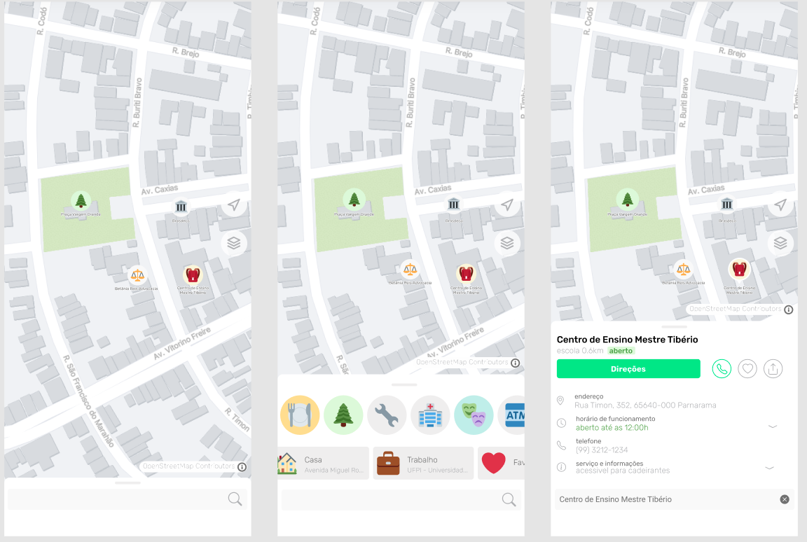
Só que para tirar essa ideia do papel eu preciso de sua ajuda, caso você tenha alguma experiencia em Flutter ou React e queria levar o OpenStreetMap a um novo patamar por favor entre em contato: gustavo22soares@pesso.al
As already mentioned in the previous text OpenStreetMap is not so friendly to the common user but serves very well for cartographers, I also received many comments that OSM is not a final product but a shared knowledge base and even some comparisons with linux… But using OSM should not be difficult or depend on the rebrand from big companies, I believe that it has a way to reach the common user and win market and being opensource and still bring more mappers to the community.
For some time now I have been working on what would be an ideal client that I would really use and recommend to my friends and colleagues. This has been growing since I read the article The Mobile Map App Part I: The Void so I decided to create a draft:
But to get this idea off the paper I need your help, if you have some experience with Flutter or React and want to take OpenStreetMap to a new level please contact me: gustavo22soares@pesso.al
I’ve noticed that Anchorage has several bus routes, yet only one has actually been somewhat put on the map (route 102). I’ve looked into what setting up a bus route would look like and after setting up another one halfway (route 10), I’ve figured out what needs to be done in order to complete a large project like this.
First off, Openstreetmap is not very good with creating a bus line easily, as tagging needs to be in a specific order according to the Wiki page on bus routes (the issue is currently being looked at as of now), so I think the method of mapping bus routes will be most efficient when done this way:
This is a pretty large project that’s going to take a bit of effort, so any outside help is greatly appreciated. Also, if you’re knowledgeable in creating bus routes and you see any errors in this method or my mapping, please feel free to correct me or the issue.
Yet here we are again, the Chinese Commies just spit on everything they thought was rightful. Yes yes, I explicitly use the term 'Commies' as gallantry since I came from 'the Taipei and environs' by their courtesies. BTW, 'Taiwan' or 'Formosa' is the place if you can't recall.
I was rather indolent to express any political views on the OpenStreetMap as it should be a site to record facts, not a place to be poisoned by political flim-flam. However, the landscape has changed too much from a niche and friendly environment to a colossal and somewhat hostile one.
More and more Chinese mappers joined as China rises, but many rather acting irrationally and nonconstructive. These mappers can mainly be categorised into 4 major doctrines:
Unfortunately, all of them were never cared to listen nor discuss, while the community members try to be friendly and sagacious. Which let me rethink the need to embrace or cope with such gibberish, rather.
Resumen: “Mapear” y “cartografiar” significan lo mismo, pero la primera es más corta y comunica el concepto de “hacer mapas” de manera más sencilla y directa. Además, “mapear” es un término aceptado por la RAE y usado en todo el mundo hispanohablante, por lo que no hay razón para evitarlo o reemplazarlo.
¿Qué verbo usas cuando quieres expresar la acción de hacer mapas? ¿Mapear o cartografiar? Esta pregunta puede parecer trivial, pero tiene su importancia en el ámbito de la traducción y la edición de mapas, especialmente en proyectos colaborativos como OpenStreetMap.
Como colaborador de traducciones “crowdsourced”, de vez en cuando me encuentro con algún traductor que reemplaza la palabra “mapear” por “cartografiar”. Esto lo hacen porque creen que “mapear” es un chilenismo o una “traducción de baja calidad” por parecerse a su versión en inglés (“to map”). Pero, ¿es realmente así?
En primer lugar, hay que aclarar que “mapear” no es un anglicismo, sino una palabra formada a partir del sustantivo “mapa” y el sufijo “-ear”, que indica acción. Esta forma de derivación es muy común en español. Por tanto, no hay nada de malo en usar “mapear” como verbo.
En segundo lugar, hay que señalar que “mapear” no es un chilenismo, sino una palabra reconocida por la Real Academia Española (RAE) y usada en todo el mundo hispanohablante. Según el Diccionario de la lengua española (DLE), “mapear” significa “hacer mapas”. Esta definición se ajusta perfectamente al ámbito de la cartografía, que según el mismo diccionario es el “arte de trazar mapas geográficos”.
Es cierto que el verbo “mapear” se incorporó al DLE en 2014, con la publicación de la 23.ª edición, y que se trató de un aporte de la Academia Chilena de la Lengua, por lo que quedó etiquetado como si fuera un término dialectal. Sin embargo, eso no significa que solo se usara en Chile ni que fuera una novedad. De hecho, hay ejemplos de uso de “mapear” en textos anteriores a 2014 y procedentes de diversos países.
Thank you EOS :-)
P.S. The copyright symbol on said tool indeed made me uncomfortable using it straight away, hence I decided to bother EOS (LOL)
J’ai beaucoup “collaboré” dans Google Maps et au décidé cet été de me degoogliser au maximum. En effet, Google a bloqué mon compte agence ads évoquant des raisons floues.
Ils ont perdu ma confiance déjà bien égratignee. En tant que mini agence web, j’évite gafam et consorts pour accompagner mes clients et amis vers des endroits plus sûrs et plus sains.
Goog. M’a fait envoyer deux mois de relevés bancaires pour qu’ils lèvent enfin l’interdiction. Ce qu’ils ont faut après deux mois, sans même envoyer un mail.
Je sais que la privacy et la protection des individus en général est ma raison de vivre (carrément).
Il en découle ce qui permet aux gens de vivre : les réseaux de distribution : data, trains, et énergie particulièrement. Surtout si c’est vert. C’est agréable de trouver des gens ouverts qui pensent un peu comme moi. Cette communauté fait beaucoup de bien à tous.
Vive le libre, vive le web, vive la vie !
Salto
While the amenity=parking tag is used “de facto”, the amenity=parking_space micromapping oriented tag has been introduced and approved by vote on 2011-05-01. The main reason for it’s introduction is to help people, disabled or not, easily find parking spots inside parking lots without any important downside to it.
Other voted proposals introduced the parking:lane=* and parking=street_side tags and while those are quite useful (I’m still reserved concerning the first), I’d rather map parking spaces directly as those kind of parking’s capacity is generally quite low. The parking:lane proposal even adds:
Consider using parking:lane=* as a simple alternative if the streetside parking spaces are stretched over a longer section of the road and no micromapping of these areas is desired.
Ha! Which fool wouldn’t want some micromapping in its life? Micromapping is love, micromapping is but the purpose of life.
The tag is especially useful in combination with the footway=acces_aisle tag (not to be confounded with service=parking_aisle which is oriented towards vehicular routing) which is used for pedestrian routing in parking lots.
This tutorial makes use of the JOSM editor along with the BuildingsTools and Gridify plugins and the high resolution of aerial imagery in France. Some similar functions may be found on other editors that I don’t know of, feel free to try and find your own workflow in the journey for the slickest parking lot micromapping.
The main difficulty about mapping parking spaces comes from its typology. Up to now I have found four different kinds of geometry and I’ll go through them from the simplest to the hardest to map in my opinion. The overall pattern of those is implicit and it’s recommended to use the parking:orientation key to specify if necessary.
Este artículo hace parte de una serie de artículos que he escrito acerca de las notas. En el primero escribí sobre el contexto de las notas frente a la comunidad de OpenStreetMap, y en el segundo sobre cómo crear, ver, y cerrar las notas desde diferentes aplicaciones. Aquí están los artículos:
En este artículo explico cómo analizar las notas y si hay muchas activas en la zona de interés, poder diseñar una estrategia para cerrarlas.
Comencemos con un servicio que ha creado Pascal Neis específicamente para notas. Antes de continuar es importante mencionar que Pascal ha creado una gran cantidad de herramientas para análisis de datos de OSM, lo cual facilita el trabajo o análisis de OSM desde diferentes aristas.
Con respecto a las notas, él nos ha puesto a disposición una página que permite ver las notas de cada país, discriminadas por las abiertas, las cerradas y las totales, donde además hace un cálculo de la tasa de resolución: https://resultmaps.neis-one.org/osm-notes
Esta página permite inducir cómo la comunidad de cada país está involucrada en el mapa, en la parte de resolución de notas. Además, puede dar una idea de cómo, de manera general, está la comunidad involucrada activamente en contribuir en el mapa. Se puede ver que los países con mayor cantidad de notas resueltas, y los de mejor tasa de abiertas/cerradas, son los países que tienen comunidades de colaboradores más involucradas y activas.
J’ai profité de l’été pour me (re)-lancer dans le chantier “serveurs de tuiles”.
OpenStreetMap France héberge génère plusieurs fonds de carte à l’aide de ses “serveurs de tuiles”:
rendu “FR”, une adaptation commencé en 2012 du style OSM de l’époque, destinée à un public francophones (noms en français en priorité, icône plus parlantes en France, etc) avec des ajouts originaux (terrains de sport, etc)
le rendu “humanitaire” largement utilisé par HOT et disponible aussi sur openstreetmap.org
le rendu “CyclOSM” , le petit dernier, lui aussi disponible sur openstreetmap.fr
À cela s’ajoute aussi OpenRiverBoat, un rendu adapté à la navigation fluviale, des rendus en langues régionales, des rendus techniques.
Les trois premiers sont assez fortement utilisés et complexes. Le rendu “FR” contient par exemple 82 couches différentes parfois multiples ce qui donne au total plus de 170 couches de dessin pour arriver au rendu final avec plus de 10000 règles qui servent à décider comment représenter graphiquement tel ou tel objet.
Le cœur est une base postgresql/postgis, qui contient les données OSM utiles à la fabrication du fond de carte et à sa mise propre mise à jour.
Les données OpenStreetMap brutes sont importées dans postgresql puis mises à jour régulièrement à l’aide d’osm2pgsql. Typiquement la base résultat occupe environ 1To.
La génération du fond de carte est faite par renderd qui utilise la librairie mapnik pour transformer les données vectorielles issues de postgresql en images en appliquant une feuille de style.
Cette feuille de style au format XML utilisée par mapnik, est générée à l’aide de kosmtik à partir un code source écrit en cartocss, une sorte de CSS adaptée à la cartographie.
This diary explores the problems with the OSM Wiki entry for service=driveway, and why is there a need for service=driveway2. In the process, it also describes the headaches encountered while trying find a optimal solution. However, deeply entrenched opinions makes this process untenable.
The topic of discussion will need to begin on how OSM tags are designed in an hierarchy, which begins with initial key-value pair of highway=service, followed by classifier tags service=driveway or service=parking_aisle. Note that highway=service without any service=* does not tell the data consumer if this is simply a minor way that is un-classified (not yet assigned a classification type such as parking_aisle or alley or driveway), or if this minor way is an implicit driveway. In general, a data consumer will assume that the way is un-classified, instead of assuming that it is an implicit driveway.
The classifier issue is the first issue present in the service=driveway Wiki entry - that suggests that minor ways linking from major roads to parking_aisles should be tagged as an implicit driveway with no classifier tags.
We seek your community input - please help us by sharing the Etiquette guidelines and giving input on the OSM wiki by September 8, 2021. We also have some upcoming consultation meetings to hear your views. ## Announcement
The LCCWG moderation subcommittee is holding two online public meetings about the revisions to the current Etiquette Guidelines, which are now open for public comment.
The draft guidelines are found here, with comments open to Sept 8:
Both public online meetings will be held via Big Blue Button in this room:
Two timeslots to accommodate a global audience.
7 AM Pacific Time (US) 10 AM Eastern Time (US) 2 PM UTC 4 PM Central European Time
11:00 PM Pacific Time (US; evening of Sept 3) 02:00 AM Eastern Time (US) 06:00 AM UTC 08:00 AM Central European Time 09:00 Nairobi 11:45 Kathmandu 1300 Jakarta 1400 Manila 1600 Sydney
See full details for the Etiquette and moderation process on the wiki -. The draft guidelines are found here, with comments open to Sept 8th, 2021
With thanks on behalf of the subcommittee
Hutan Kota Kaombona Kota Palu
I have mapped areas of Bodmin Moor especially around Minions which was originally a mining settlement. Large parts have been mined until around 1900, but it is likely that there has been mining since prehistory.
Early mining, as least medieval, was largely based on streamwork. This is described here (https://historicengland.org.uk/listing/the-list/list-entry/1020051). That describes a particularly large example near Minions. This website (https://www.aditnow.co.uk/Photo/Gonamena-Tin-Streamwork_50013/) includes some photographs.
As seen in those pictures, the ground is heavily disturbed. That case is fairly extreme. Often the area is smaller, but usually following a stream, and only a few metres deep. Frequently the ground is sandy with fine gravel, presumably from the extracted waste. Actually that is true in places at Gonamena, and it is also true of other smaller workings around Minions.
We don’t (yet) have any good tagging for these places, but I had used landuse=surface_mining which I think captures these distinctive areas quite well. Together with disused=yes. Unfortunately another mapper decide to change that tagging to landuse=quarry which is just plain wrong.
I have now changed to historic=mine (I am not keen on that) and landuse=disturbed (also not really a landuse) until someone comes up with better ways of capturing these special places. Perhaps I might change historic from mine to surface_mining.
There is a thread on talk-gb@openstreetmap.org about this.


%20by%20Vince%20Emond.jpg)


