 OpenStreetMap

Magic Earth routet dich im Kreisverkehr, von der Pragerstraße kommend, in die erste Ausfahrt in die Ernst-Vasovec-Gasse. Um ins Bauhaus zu gelangen müsste man die 2. Ausfahrt nehmen. Beim darauffolgenden Kreisverkehr bin ich schneller, wenn ich die 2. Ausfahrt nehme und die Nebenfahrbahn(Wiener Straße) benutze. Hier ist zwar eine 30km/h Geschwindigkeitsbeschränkung aber ich umfahre die Ampel an der Krezung Wiener Straße/Weißes Kreuz Straße. (Magic Earth routet mich in die 1. Ausfahrt, zur Ampel) An dieser Ampel bin ich letztens cirka 1 Minute gestanden. Vom 2. Kreisverkekehr weg (1. Ausfahrt) auf der Wiener Straße über die Kreuzung (Ampel) nach links zum Bauhaus cirka 110 Sekunden. Fahre ich die Nebenfahrbahn (30 km/h), ohne Ampel cirka 60 Sekunden
Users' Diaries
Recent diary entries

Hier,
je me suis fait plaisir en lisant ces trois blogs :
- le blog officiel du district de Kerguelen, un des cinq districts des Terres australes et antarctiques françaises - TAAF
- blog officiel du district de Crozet
- Lent a charger , saint paul
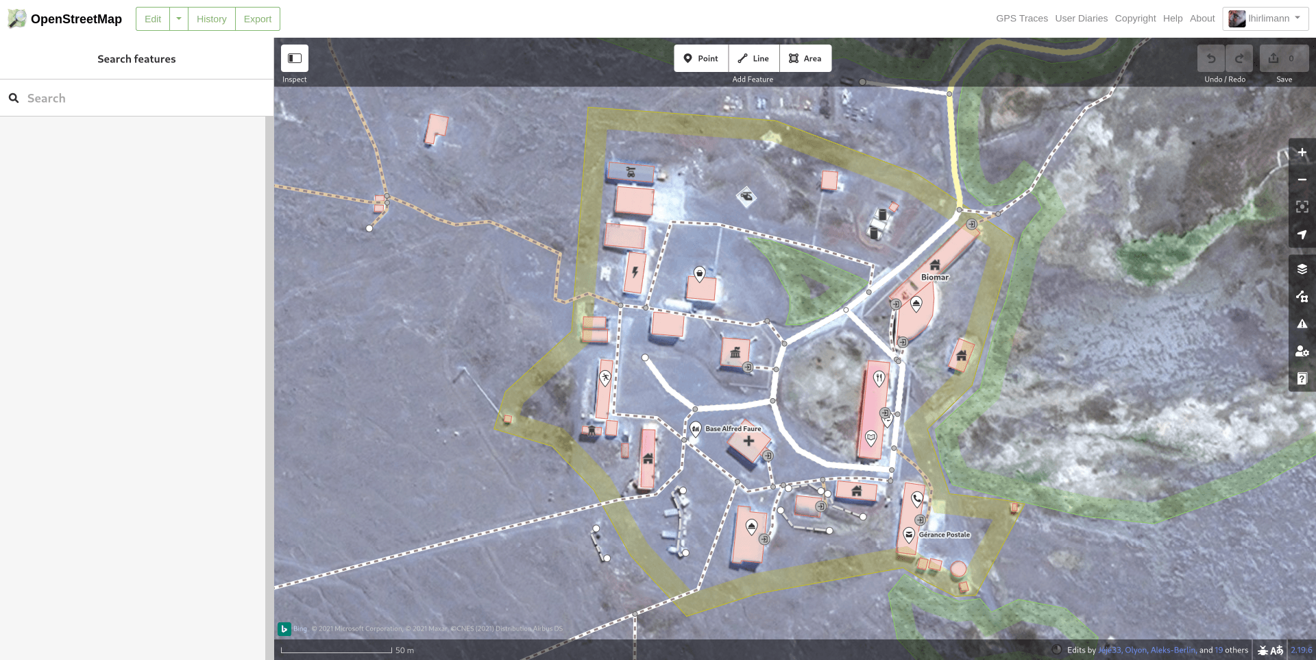
Aujourd’hui je regarde la carte et ho surprise :

Hello,
I want to show a map in an other program (3DVista) to show customers the position of the hotel. So I copy the HTML code and put it into this program. When I activate it and show it in the internet the map is to see but not the map marker. Is the problem known? Can I do anything?
best regards Andreas Moeller, Berlin, Germany

Today I’m introducing this road mapping tool in Openstreetmap https://mapwith.ai/rapid#background=Maxar-Premium&disable_features=boundaries&map=16.20/-7.83211/-49.36525 where it makes mapping in Openstreetmap very easy.
The tool detects unmapped roads in Openstreetmap through artificial intelligence and makes life easier for the mapper,
More tools can be found on the site of UMBRAOSM - União dos Mapeadores Brasileiros do Openstreetmap.
Hoje venho apresentar essa ferramenta de mapeamento de estradas no Openstreetmap https://mapwith.ai/rapid#background=Maxar-Premium&disable_features=boundaries&map=16.20/-7.83211/-49.36525 onde facilita muito o mapeamento no Openstreetmap.
A ferramenta detecta estradas não mapeada no Openstreetmap atraves de inteligência artificial e facilita muito a vida do mapeador,
Mais ferramenta pode ser encontrada no site da UMBRAOSM - União dos Mapeadores Brasileiros do Openstreetmap. https://www.umbraosm.com.br/ferramentas-para-o-osm.html
Raphael de Assis
Recife/PE. - Brasil

A NEWLY DEVELOP SUBDIVISION
Ja, es ist Jahr 2 mit Corona.
Bei uns ist aktuell wohl die britische Variante die verbreitetste, wobei – wenn es nach der WHO geht – ab sofort griechische Buchstaben die Varianten bezeichnen sollen.
Wo die doch jeder alle kennt – oder gibt es da mehr als 5 Buchstaben? Die Wikipedia nennt 24 “klassische” plus 7 “nicht-klassische” Buchstaben. Direkt mal endlich auswendig lernen.
Wie geht es dann wohl nach 33 Varianten weiter?
OSM? Achja, aktuell trendet die App “StreetComplete”. Diese zeigt dort, wo man gerade ist, Fragen zu unvollständigen Mappings. Etwa, wieviele Etagen ein Gebäude hat, welche Bürgersteige es gibt und ähnliches.
Ist eigentlich ganz spaßig.
Hello everyone, through this diary I would like to introduce myself to the broader OSM community and share plans regarding my GSoC project
About Me:
I am Zohaib Ansari, an undergraduate student in Electronics and communication from New Delhi, India
I spend my free time learning programming, working on my own small open source projects
I was introduced to OSM by a friend I play geoGuessr with, and coming across Vespucci made me interested in applying to OSM as the project idea seemed pretty interesting
Element history widget for Vespucci
During the GSoC coding period, I will work on creating the element history widget as a library for android apps, the element history widget will bring a feature similar to JOSM’s native element history comparison dialog to android (with certain platform limitations)
The Main features of this library would be:
- Display information about all the iterations an OSM element has gone through
- Selection of any 2 versions of the element from the history and allow comparison between them
- Displaying other information including coordinates, changesets etc
Apart from creating the library, I would also work on providing robust test cases for the library itself and for Vespucci after the library has been integrated with it.
I will keep a detailed account of my work in the github wiki of the project and will also keep this diary entry updated throughout my time working with Vespucci, please feel free to reach out if you have any questions regarding my work or anything else!
Link to detailed Roadmap and Progress for this project: Wiki
Introduction
Hi OSM community! My name is Vuong Ho, an international student at the University of Rochester in the U.S. I am currently living in Ho Chi Minh City, Vietnam, though, since due to Covid-19, I haven’t had the chance to go the States yet. In my free time, I like to tinker away with my small personal projects, play games with my friend, and watch cat videos on Youtube. Once this pandemic is over, I am thinking of going mapping around too!
Though I have never contributed to open-source, I really like the idea of openly sharing software for public use and would like to contribute to a project someday. Therefore, I am really glad to have the opportunity in this GSoC to contribute to OpenStreetMap!
My GSoC project: Opening hours tag evaluator
As noted by Simon Poole, the current opening hours parser lacks a complete evaluator for its input opening hours tag. This project will center around building an evaluator to determine if an input of date and time translates to a location is currently opened or closed based on an opening hours tag (specifications here). This evaluator will also support checking sunrise/sunset and holiday information, if any is provided in the opening hours tag, since these are supported by the parser.
The evaluator will be in the form of a data structure resembling a compact calendar, though this may change over the course of the project since I will be making use of the test-driven development framework to develop the evaluator. The information on sunrise/sunset and holidays is taken externally, using other open-source libraries and data. My full project proposal can be found here.
The milestones for my project in the span of two months of this year’s GSoC are:
- Creating a simple evaluator that supports checking open/close status of time and day
- Adding support for sunrise/sunset information
- Adding support for holidays information

- A közvetítés a megszokottól eltérő helyen lesz! meet.jit.si/osm-hu
A fagyizáson személyesen felmért adatokat kombinálnánk a többi meglévő forrásunkkal és ez alapján pontosítanánk a helyszínt. További információk a Wiki oldalon olvashatók:


Hello everyone!
I will be sharing my GSoC’21 journey with OpenStreetMap through this diary. Feel free to ask me questions if you have any, I would be delighted to answer them!
Who am I?
I am Antonin Jolivat, a French student in an Engineering School which specializes in Computer Science.
Passionate about Software Engineering, I spend many time to discover new domains and create personal projects related to them. The rest of my time, I like to read about what others people do, entertain myself with various things and work out to stay in shape.
I came accross OpenStreetMap while working on a project involving maps and it stayed in my mind. I recently got involved a lot more as I have chosen OSM as my organization for the GSoC’21, and I am very happy to have made this choice! :)
My GSoC Project: QA Reports Extraction Tool for Nominatim
This project is mainly concerning Nominatim but it will help to increase overall OSM data quality.
Nominatim is the OSM’s main geocoding software used to process geocoding requests on OpenStreetMap data. The software uses its own database schema which differs from the one used by the main OSM database. As a result, Nominatim processes OSM data in a way that allows to discover a lot of inconsistencies. The idea of the project is to build a Quality Assurance Tool which will analyze the Nominatim database and extract errors from the OSM data.
Those errors would be made available to everyone through a map, so that OSM mappers will be able to correct them easily.
At the beggining, we plan to use Osmoscope to display the data errors through a map. This map may be available under https://nominatim.openstreetmap.org/osmoscope (/!\ subject to change)
In the future we could even imagine to share the data errors through other tools, like in the form of challenges suitable for https://maproulette.org/.
The main goals of the project are:

About Me
I am Yash Srivastava, an undergraduate student from the Indian Institute of Technology at Roorkee in Uttarakhand, India. I usually spend my time exploring different technologies and creating various projects.
Apart from development, I enjoy solving rubix’s cubes, reading books, watching anime. I also love adventure sports and travelling to different places.
Journey to OSM
I was working on creating a website for my college society where we needed to integrate a map to find the location of our college society.
At first, I tried with Google Maps integration, but the location was not found there and integrating it also required some API keys, which involved more work. Later while searching for alternatives, I found out about OpenStreetMap and how we can integrate it with our website and make changes to its database in a hassle-free way.
GSoC Project: Interface for reporting search bugs for Nominatim
The project proposal can be found here
Currently, there is no standard platform where users can report geocoding bugs or send feedback. Generally, if a user wants to give feedback or report a bug, one has to have a GitHub account and then create an issue that is not feasible. Thus we aim to create an Interface for reporting search bugs for Nominatim.
It will have the following project goals:
-
The interface will be mobile-friendly.
-
The backend will store log files for the reported bugs.
-
Test suit will be created and iterated parallel to both frontend and backend.
Since this year GSoC has a shorter period thus we will have the following stretch goals:
-
We will be adding a python script that will export log files to a CSV format that can be processed through Geocode-Tester to recheck the reported bugs.
-
Dockerizing the whole application for the portability of code.
-
Creating a Continous Integration pipeline using GitHub-Actions.
-
Adding internationalization support.

Creo que un problema importante para la calidad del mapa son los mapathones.
Durante la pandemia se han multiplicado los mapathones on line. A los que yo he asistido, normalmente, tras una introducción, se dividen los mapeadores en varias salas. Cada sala tiene asignado un representante del equipo organizador para resolver las dudas del grupo
Se podrían implantar dos normas para mejorarlos:
1.- No admitir al mapathon a mapeadores nuevos que no hayan completado al menos un tutorial de los que hay en la red (learnosm.org, el incluido en la ayuda del iD Editor, …). Yo veo que actualmente se admiten mapeadores que ni siquiera se han registrado aun en OSM. Los que no hayan podido completar ese mínimo trabajo previo pueden ser dirigidos a un próximo mapathon
2.- El equipo organizador debe comprometerse a revisar todos los changesets del mapathon en un plazo corto de tiempo (¿7 días?) y mandar un informe de ello a cada mapeador. Si es preciso, se reduce el número de mapeadores al número que pueda revisar el responsable de cada sala.
El equipo organizador debería velar por la categoría de los responsables de cada sala de mapeo

Are you wondering what to map next? Don’t worry we got you covered! We have three interesting tasks as the next maproulette challenges for you all. They are for mappers who are just starting or are experienced. Here are the tasks for you all:

- Connectivity checks: https://maproulette.org/browse/challenges/17714
- Sharp Angle checks: https://maproulette.org/browse/challenges/17716
- Invalid turn restrictions: https://maproulette.org/browse/challenges/17715
- Crossing ways: https://maproulette.org/browse/challenges/17943
- Wrong one way- double way - https://maproulette.org/browse/challenges/17958
- Road Islands - https://maproulette.org/browse/challenges/17950
Put your mapping hats on and let’s do some mapping!
We would love to hear suggestions and feedback from you on these tasks so that we could better ones next time.
PS: Can’t wait to see who is going to be on top in this challenge (psst.. We have some goodies for you) 😉
Happy Mapping!

maps are the guidance of all places and proper locations for all.
Is it possible to create an (Area-)Symbol for wide Stairs which are broad but with few steps, only. This could be used in general, too.
Primeiro Voluntário no Brasil.

Hoje Pesquisando os Usuários no OpenstreetMap acabei encontrando esse usuário com registro de Primeiro Voluntário no Brasil, a data do seu registro e de 2006 e o Nome de Usuário se chama, Claudomiro e o seu Diário osm.org/user/Claudomiro/diary relata que é o primeiro voluntário no Brasil, Seu Diário também mostra informações de Viagem, encontros com outros Mapeadores e todo o Inicio da Comunidade Brasileira do Openstreetmap que hoje conta com muitos mapeadores que se registra todos os Dias.
About 6 weeks ago, I signed up to openstreetmap.org (OSM) to map my contact’s addresses and my public transport routes. My thinking was that adding these details will mean I will use OSM based apps everyday. When I add new contacts in the future, I will add their addresses to OSM too.
Of course, the first address I added was my home address and then the addresses on my street. I posted my initial impressions of OSM in my diary and people commented about my diary entry. I read their comments and their diary’s. I learnt from their diary’s that addresses can be automatically imported to OSM from government data sources as long as OSM have permission to use those data sources. I didn’t want to be doing work that could be automated, so I checked to see if my government offered open data that listed all the addresses in Australia. I learnt that such data existed and that another OSM mapper was requesting the appropriate government permissions to automatically import this data to OSM. I also learnt that with a powerful computer and AI software that buildings can be mapped too. I felt quite disillusioned and decided to take a break.
I came back with the idea of recording GPS traces of my public transport routes, but then I learnt that the GPS on my Nokia 6.2 has a known issue with accuracy.
Then I decided I would add nodes for local businesses, which is based on local knowledge and will not be automated for many years to come!! Initially, I thought I could map those businesses off the top of my head having passed them for years. As soon as I sat down at my PC to add those businesses I realised I couldn’t remember some businesses.
So, I went down the street, mentally recording the sequence of the businesses. I returned to type in the business names and their addresses. OSM made me really look at my surroundings and there were things I didn’t notice in my neighbourhood. That’s when I got hooked on adding more information about these businesses to OSM.

This diary is about load testing. I find load testing useful mainly because of two reasons: 1. it shows multiuser access problems; 2. it shows how good is the implementation.
The idea is to simulate mapathon. A mapathon is an event where multiple mappers map the same (big) area. To manage the work, the area is divided into smaller squares. Then, each mapper asks the server to map or review a square, works some time on the square, and finally asks the server to mark the square as needs mapping, needs review, or is done.
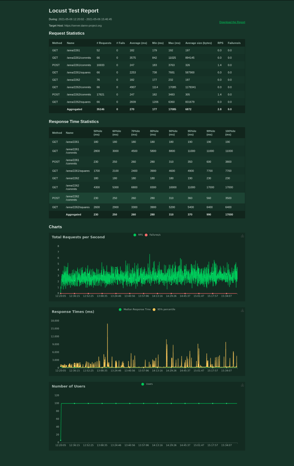
I use locust.io to load test the damn server. The test file is part of the repository. There is 80 % of mappers, 20 % of reviewers, and 2 testing areas. Each mapper/reviewer works for 30 - 60 seconds, then waits for 30 - 60 seconds, and then works again. All the mappers are spawned within the first minute. The test is stopped soon after there is 0 % to map for both of the areas.
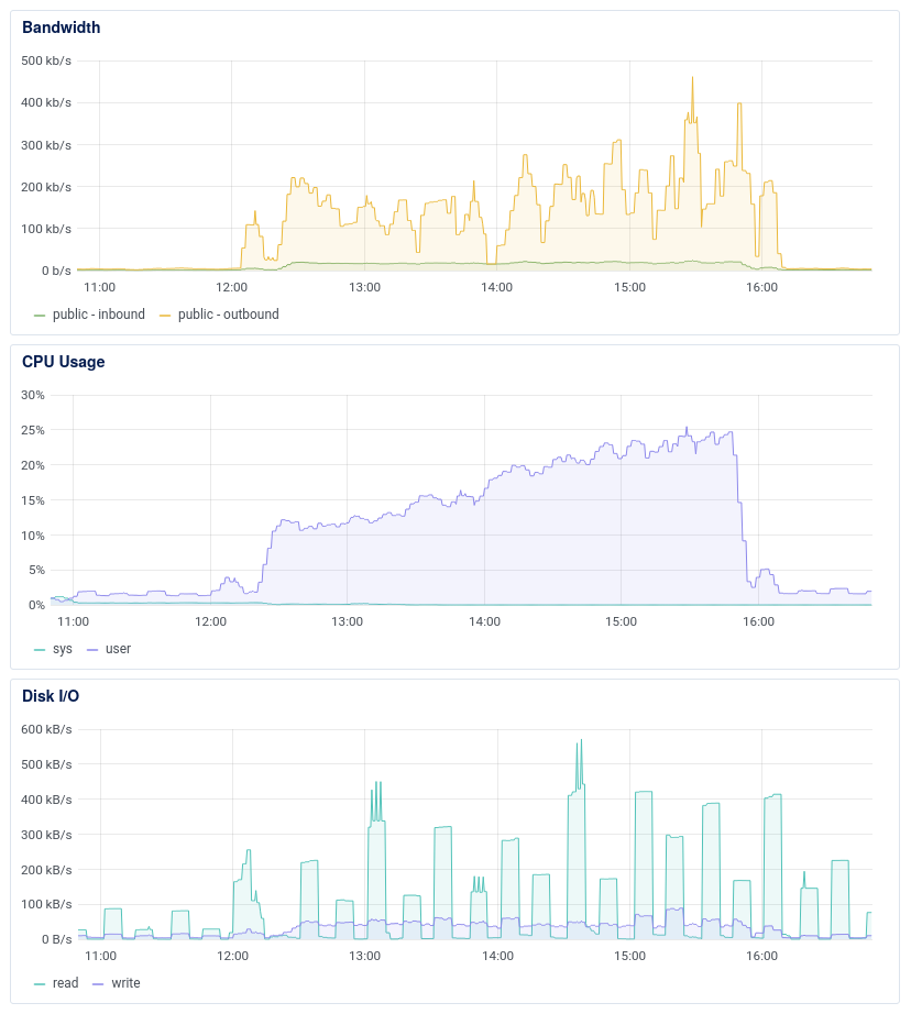
damn-project.org runs on $5/month VPS with 1 GB RAM, single 2.2 GHz vCPU, and 25 GB SSD disk.
100 mappers handled The first round of load testing gives the idea about the server after the refactoring. The average response time for 100 mappers is 270 ms. Not bad, I would say.
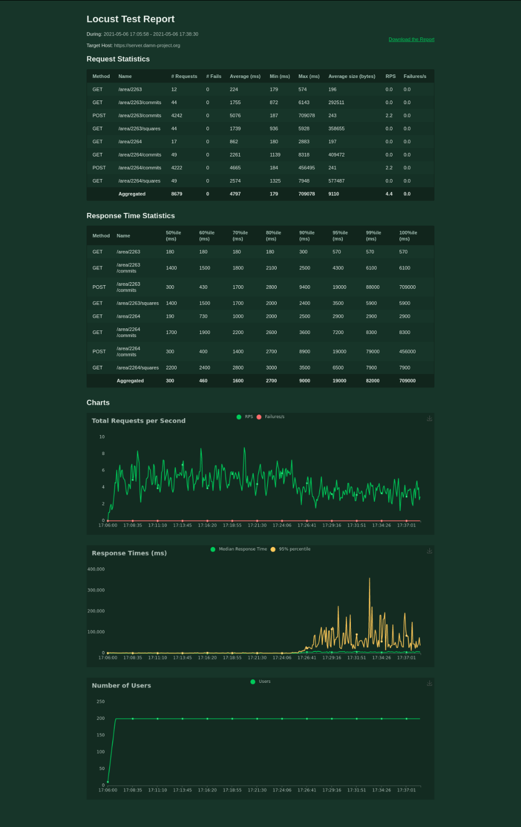
It’s a bit worse when testing 200 mappers, though. I’ve stopped the test after 20 minutes.
Some improvements Two years ago, I decided that there must be some better solution for the problem of dividing a big area into smaller squares. I found that there is PostGIS extension to PostgreSQL so I decided to go with it. Two year later (now,) I’ve discovered database indexes.
Also, I’ve read part of the documentation and set postgres parameters.
Finally, I switched gzip on.
1st traced to this place.


Quand j’ai commencé à cartographier en septembre dernier, j’ai eu la chance de rapidement tomber sur un territoire vierge dans OSM. Par territoire vierge, j’entends qu’il existe quelque chose sur le terrain mais qu’OSM n’en a pas connaissance. Aucun rendu ; visuellement, rien.
À vrai dire, j’étais tombé sur plusieurs zones très peu renseignées, mais il y avait toujours une petite trace de quelque chose. Ici, rien.
Ce qui m’a marqué dans ce cas-là, c’est qu’il s’agit d’un parc animalier touristique et qu’il n’est pas récent. Vous l’aurez deviné, c’est la Vallée des Tortues. Charmant parc animalier, modeste, pour petits et grands, qui se trouve à Sorède, non loin de la frontière espagnole.
🐢 http://www.lavalleedestortues.fr/
Si vous passez dans le coin, je vous invite à y faire un tour.
Au départ, donc, rien.
