Users' Diaries

Recent diary entries

Posted by c tito young on 9 February 2021 in English. Last updated on 10 March 2021.

Spanish: Geoglifo de Dieu Incas con Serpiente

The geoglyph of the Dieu Incas with Serpent is over 100m wide x 200m long. Oriented north to south, it sits on a moderate slope surrounded by other geoglyphs telling a themed story. Its profiled head, body and snake headwear faces east and the figure of this subject becomes less and less distinguishable below its waist. The depiction is a man, carrying a backpack, with a large python snake coiled on its headdress. It looks down staring at its hand. Both the snake and him are directing their view to the same place, but its difficult to determine exactly what. He has long hair, wears a thick coat and one can see his backpack is tightly bundled with what appears as ropes. In its backpack it carries the head of a cadaver, and helmet and some other stowed items.

Location: La Primavera, Vista Alegre, Province of Nasca, Ica, 11401, Peru

I want to share a community investment initiative HOT Is piloting in collaboration with OMDTZ (OpenMap Development Tanzania).

Over the next five years, HOT aims to support a movement of individuals and communities who create and use OpenStreetMap data to improve local lives and livelihoods in places vulnerable to crisis or experiencing multidimensional poverty. The strategy for using the Audacious project funds to achieve this centres around moving decision-making, resource allocation, support and engagement closer to these places. Partly, this is through the launch of four regional mapping hubs, but we also want to try and innovate in other ways.

HOT’s microgrants programme has proved successful over the years but we know that our reach in many places is limited and that, despite a diverse community panel for selecting winners, we cannot have a deep understanding of the context (and therefore the challenges, opportunities and constraints) in every one of 94 countries.

For this reason, we are piloting a devolved community investment programme, where we can pass on the budget for multiple grants to a trusted partner (in this case, OMDTZ) to design and implement a programme at a national level. With a few caveats (around principles, objectives, diligence and reporting requirements), we want OMDTZ to be free in designing a programme of community support and investment that works for Tanzanian contributors, communities and organisations.

We hope that by doing this the funds will be more accessible and have greater local reach, that the funded work will have greater local relevance and impact and that we (HOT) and others can learn from OMDTZ’s successes and failures and improve our own programme.

We also hope that, if the pilot is successful, we are able to replicate or adapt a similar strategy in other countries with strong OSM community organisations. In fact, if you think this is something that could work where you are, we’d love to hear from you.

See full entry

Posted by Rob Lanphier on 9 February 2021 in English. Last updated on 14 February 2021.

I think I’m getting the hang of OSM editing again. Back when I lived in West Seattle, I did a lot of OSM editing of the really-poorly aligned maps of my neighborhood. Once I moved to West Portal, I found OSM didn’t seem to need as much help in my neighborhood. I’m in a different neighborhood of San Francisco now, which the maps aren’t as good, but I’m hoping to improve them.

I’ve created a grouping (a “road route”) for Guadalupe Canyon Parkway: https://www.openstreetmap.org/relation/12291160. My hope is that I’ll learn how to do this correctly by editing a portion in an area that many editors know well, so that I can do things correctly when I’m in an area that most other folks don’t know well.

UPDATE: I created an item in Wikidata for this road (https://www.wikidata.org/wiki/Q105488967) and linked relation/12291160 to it.

Location: San Mateo County, California, United States
Posted by ikiya on 8 February 2021 in Japanese (日本語). Last updated on 9 February 2021.

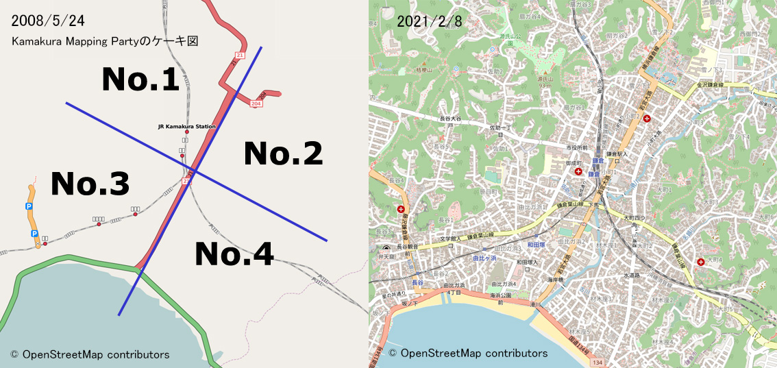
2008年、国内OSMメーリングリストTalk-jaでのコミュニケーションが活発になり、MLの中でマッピングパーティー開催が提案され、マッピング開催地は鎌倉と決まりました。5月24日(土)鎌倉駅前にはじめて?日頃MLで活発なやり取りをしていたメンバーがオフラインで顔を合わせることとなります。この日ここから現在まで長いお付き合いになっています(感謝)。

2008年5月 第一回鎌倉マッピングパーティー

kamakura2008mp


Active mapping daysが3月に3000日となります。 記念としてカウントダウン的にOSMに関わる出来事についてふりかえり日記を書いています。 マッピング日数は“How did you contribute to OpenStreetMap?”を参考にしています。Pascal Neis氏に感謝します

Posted by c tito young on 8 February 2021 in English. Last updated on 11 March 2021.

A side view of an octopus geoglyph 25m long x 20m wide shows an etching of eight arms and two eyes, facing east on a moderate sloped land. Its arms loosely coil with one of its eight arms appearing to be holding on to some sort of object. It is unclear what is the purpose or what was intended by drawing of this octopus

There is another geoglyph to the east of the octopus, It is unclear what if there is any relationship this octopus geoglyph has to that object. .

Location: La Primavera, Vista Alegre, Province of Nasca, Ica, 11401, Peru

Traduction fr : Un système d’exploitation Ubuntu 20.04 virtualisé / léger sur Windows 10

We dont all have access to a Linux OS, but note for Windows 10 users, that you can easily install a virtualized Ubuntu 20.04 OS. It will work simultaneously with Windows and will require little ressources. See this tutorial on how to install WSL2 and Ubuntu 20.04 https://alessio.franceschelli.me/posts/windows/wsl2-upgrade/

As said in the tutorial :

« WSL2 is the second iteration of the Windows Subsystem for Linux which finally allows running linux virtualized inside Windows. This new version brings real  virtualization using a real linux kernel, but, compared to a traditional virtual machine, it runs on a lightweight hypervisor getting close to bare-metal performance.»

You can even communicate with you Windows PostgreSQL server, replacing localhost by samenet

ie. psql -h samenet -p 5432

If you have problems to communicate through internet, look at your firewall to assure it does not block ougoing links from your linux OS.

Good solution to tests / Develop. While writing test scripts for changesetMD Replication scripts, I was able to use this solution to test easily on my laptop.

Всем привет.

Наткнулся на ролик компании “Racurs”.

Ход строительства Крымского моста на радиолокационных снимках Sentinel-1.

Цитата:

Ролик был создан на основе 40 разновременных снимков, полученных радиолокационными спутниками миссии Sentinel-1. В набор попали изображения с мая 2015 года по ноябрь 2017 года.  

Тема мне интересна и есть желание научится чему-то новому, особенно – обработке радарных снимков для выяснения зон паводков/наводнений/etc., как пример:

а также, создание карт вертикальных смещений - после землетрясений, активности вулканов, панических сообщений СМИ о “просадке мостов и/или сооружений” :

Данные можно использовать для оценки объема и границ кризисного картографирования. Где точно нужно уточнить или срочно создать с нуля, по уже устаревшим снимкам.

See full entry

Location: Краснодарский край, Южный федеральный округ, Россия

The humanitarian OpenStreetMap Community Working Group has taken the decision to revisit our scope and purpose.

We want to better serve…

  • OSM communities in places vulnerable to humanitarian crisis or experiencing multidimensional poverty
  • Communities or orgs that use (or want to use) OSM for social impact
  • People that want to show solidarity with these communities through collaboration and support.

…and be less focused on the Humanitarian OpenStreetMap Team (HOT) specifically.

Draft community definitions

In order to work out how to evolve, we would like to invite interested people to join us in one hour workshops to try and understand what scope, principles and objectives will serve this new purpose. We would love to have a diversity of people and perspectives inform this work.

The insights from these workshops will be used to inform a draft of the working group’s new terms of reference, which will be published in advance for consultation.

See full entry

Posted by c tito young on 8 February 2021 in English. Last updated on 11 March 2021.

The 60m wide x 70m long front facing geoglyph of the Sun God is oriented close to northeast to southwest. This representation shows a stern jawline and stern mouth, two piercing eyes, and prominent nose lays on a moderate slope. The artwork has shoulder length hair and feather headdress like crown. The face depicts high cheekbones. There is no references to a torso arms or legs. The head faces straight forward, with little understanding on how it related to other nearby geoglyphs.

To the left of this geoglyph (5m) is a 25m x 25m geoglyph, It seems to be oriented in the same direction as the geoglyph of Sun God, but how its related is not clear.

Location: Vista Alegre, Province of Nasca, Ica, Peru
Posted by c tito young on 8 February 2021 in English. Last updated on 15 April 2021.

The Geoglyph of the Groove Bill, 210m long x 100m wide is of a flying bird heading pointing in the westerly direction. The etching shows a side view of a body, and extended wing is propped over its body, with a long tail fluttering behind. Situated on a land surface of moderate slope along with many other geoglyphs might suggest this flying bird depiction might be part of an story. Other geoglyphs near this animal image, might or might not be necessarily related.

Location: Vista Alegre, Province of Nasca, Ica, Peru

Planteamiento

Las zonas rurales son las que menos atención tenían (cuando comencé a mapearlas en octubre de 2019) y faltaban de identificar muchísimas localidades claves, además de elementos naturales como picos, ríos, mesetas, cañones, dunas, etcétera.

El boom por el senderismo para afrontar la poca actividad física por el COVID19 llevó a la gente común explorar cerros y áreas naturales resultando muchos rescates por las autoridades.

Objetivo

Tener herramientas de localización para gente común y estas sean difundidas por las distintas aplicaciones de mapas. Guías confiables y lo más completas posibles para evitar extravíos. Dado que no se puede obligar a la población a no acudir, por lo menos darle un poco de ayuda para no perderse.

Desarrollo

Lo primero fue señalar las distintas localidades, para lo cual fue de vital importancia apoyarme en tres instituciones oficiales que tienen los datos más completos: el INEGI, el Instituto Nacional Electoral y la Secretaría de Comunicaciones y Transportes a través de su organismo de Caminos y Puentes Federales. También me apoyé, en algunos casos de controversia en documentos catastrales municipales y verificación en el lugar mismo.

En cuanto a los elementos naturales, la mayoría estaban ya documentados en el Mapa digital de México y en sus cartas topográficas de hoja en distintas escalas, pero también existían elementos muy conocidos que no aparecían en esta cartografía, para lo cual tuve que acudir a los lugares acompañando a equipos de senderismo como también pedir información a los habitantes para tomar nota y colocar dichas referencias.

See full entry

Location: La Hacienda, Rayones, Nuevo León, México
Posted by SomeoneElse on 7 February 2021 in English. Last updated on 14 June 2022.

The OpenStreetMap Community Index is designed to show people what community groups there are within OpenStreetMap, in any part of the world. If I look near me I see a local pub meeting (sadly on hold during the pandemic), some country-level resources, and then international resources.

On a couple of occasions I’ve seen things that are missing or need updating, and this diary entry is designed to complement the existing documentation to describe what needs to be done to fix that.

Creating a local copy

In my case I already have a fork of https://github.com/osmlab/osm-community-index at https://github.com/SomeoneElseOSM/osm-community-index. There’s a “fork” button in the top right of Github’s UI that allows you to do this.

Next, I’ll create a local branch to work on. The default branch at https://github.com/SomeoneElseOSM/osm-community-index is “main” and the UI will say “This branch is even with osmlab:main.” because (in your case) you’ve only just created it. In github’s branch selector just type the name of the new branch to create. In this case I created “add_forum_at_world_level”, because I noticed that there wasn’t a link to the OSM Forum at the international level, although there are many links to country-level forums from the community index.

Next, “git clone” your repository wherever it is you want to work. I’m working on a completely new virtual machine to do this, so I have to take a slight detour first - see “setting up ssh access to github” below. Once that’s done:

mkdir ~/src
cd ~/src
git clone git@github.com:SomeoneElseOSM/osm-community-index.git
git checkout add_forum_at_world_level

Note that I’ve used a version of “git clone” that is designed to work with ssh. Github is (rightly) moving away from password-based verification and will send you a warning email if you try and use a password during the transfer period.

See full entry

Location: 21.871, 33.737
Posted by c tito young on 7 February 2021 in English. Last updated on 11 March 2021.

The geoglyph of the emu 75m wide by 150m long and oriented north to south on a moderate sloped terrain depicts an emu feeding from the ground. The bird is facing the viewer but also turned towards the east. There are suggestions of heavy feathering for the animal, but the current sat image is unclear if suggestions of repeated coloration changes that might be representative of long plumes of feathers were intentional for the animal. Look along of the animal’s head, neck and back. The artist rendition of the animal gives it ergonomic stature and gives the feeling this animal is a survivor. It is unknown at this time whether or not this image is related to other nearby geoglyphs. The three toed, long legs, body, long neck head and beak are etched wonderfully. It is unclear if the animal is related to the other nearby geoglyphs and exactly if there is additional stories to be told regarding this artwork.

Location: Vista Alegre, Province of Nasca, Ica, Peru
Posted by ikiya on 7 February 2021 in Japanese (日本語). Last updated on 9 February 2021.

まだ情報の少ないOpenSteetMapについて調べて2007年12月アカウント登録しました。編集操作の練習をしたり、どうしたら地図が更新されるのかなど少しずつ理解できてきました。 そして2008年3月、待望のOSMの国内メーリングリストTalk-ja: OpenStreetMap talk ML for Japanese User が立ち上がります。これで国内に芽生え始めていた個々のOSMマッパーがつながることとなります。OSM国内コミュニティの誕生です。そして私にとってもOSMが沸騰する、世界が変わる、忘れられない2008年が始まります。

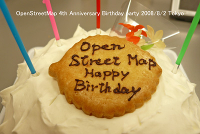
OSM4thcake 第4回OpenStreetMap記念誕生パーティー 2008/8/2


Active mapping daysが3月に3000日となります。 記念としてカウントダウン的にOSMに関わる出来事についてふりかえり日記を書いています。 マッピング日数は“How did you contribute to OpenStreetMap?”を参考にしています。Pascal Neis氏に感謝します。

Posted by c tito young on 6 February 2021 in English. Last updated on 11 March 2021.

One huge question I have about time used in tracing Nazca lines and its shapes, is the lack of certain geometries, one would expect. Very often, long distances of perfectly straight lines, with long acute angles are common, as with lots of evidence where two lines starting rather close to each other might meet many meters away to a single point.

What seems rare is having multiple lines being the same exact length, and perfect right angles. Angles that are 90 degrees or that angles of 30 or 45 degrees, perfect circles, semi circles and/or use of tangents are never seen or given much importance. The uses of golden sections, and those proportions, never seem to be given much importance. Curves and tangents from other shapes and curves are occasionally shown, plus those that relate to a specific shape or object might be well represented. significant geometric importance. One also would expect to see more use of Pi, but without true perfect squares, rectangles or circles, any calculation using Pi is also not given any special importance. There also doesn’t seem to be much whole number equally divided segmented distances. While occasionally a line might bisect, its for more organic than just that therefore not based on any grid pattern.

See full entry

Location: Buenos Aires, Nasca, Province of Nasca, Ica, Peru