Users' Diaries

Recent diary entries

Posted by bobwz on 5 November 2020 in English. Last updated on 6 November 2020.

This will be my third and final installment in a series of articles discussing device I’ve used when preforming surveys when contributing to OSM.

In the first article, I talked about accuracy limitations associated with GPS signals while the second gave an overview of four specific mapping devices I’ve personally used. In this article I’ll compare the accuracy of three devices previously discussed using GPS traces.

Test Setup

To test device precision, I recorded GPS traces along a hike with a variety of line-of-sight obstructions to the sky with each device recording at the same time. The traces were assigned colors to help differentiate each device:

  • Samsung Galaxy S10e - Orange
  • EcoDroidGPS - Green
  • Garmin GPSMAP 66sr - Purple

The arrangement of the devices are as follows:

  • The EcoDroidGPS was placed in a backpack with the reciever on an antenna mast above my head.
  • The Garmin was attached to one of the backpack straps with the built-in antenna stub poking just above my shoulder.
  • The S10e was in one of the side pockets of the backpack.

The EcoDroidGPS and S10e location information were sampled every one second within a GPX track using the app OsmAnd. The 66sr records as an “activity” with location information sampled every one second. The resulting GPX track was downloaded from the device.

Results

The Bridge

Before arriving to the trailhead, I had to walk along the shoulder of a bridge spanning a medium size river. The bridge is long enough to offer a best case scenario for accuracy. There is a good 45 degrees of sky visible from most angles in the center of this bridge.

The result of a stretch of road with minimal interference is quite predictable, all three traces are stacked right on top of each other without significant deviation.

See full entry

Posted by Ngawit Aman Daniw on 5 November 2020 in English.

After being inactive for a long period, I am back to contributing again to OpenStreetMap. The once-poor Internet infrastructure in my area has hampered my online mapping in the last five (5) years. Fortunately, the connectivity has improved a lot now (albeit intermittent at times, as one would expect in a mountainous terrain that generates its own, unique weather system affecting signal quality). Another factor that discouraged rigorous mapping here in the North is the long absence of updated satellite imagery. Thank mapping gods, we now have updated satellite data. Yey!

In this article, I’ll continue sharing my experience on finding a generally-available commercial device to be used with preforming surveys for contribution to OSM. I previously wrote about GPS precision and why, by itself, it is limited to meter precision.

Below are the devices I’ll be discussing based on my own usage. I’ll share how I used them and my thoughts on each. In a final article of this series, I’ll provide a GPS trace comparison of the EcoDroidGPS, smartphone, and Garmin GPSMAP 66sr as well as which device I’d pick if doing it all over again.

Modern smartphone (Samsung S10e)

The first device I used for surveys and general contributions to OSM was with a smartphone. I currently use a Samsung S10e with the below Android apps depending on the complexity of my contribution:

  • OsmAnd - Used for adding basic POIs and creating GPS tracks with built-in plugins.
  • StreetComplete - Used for casual contributions and tag refinement on existing features.
  • Vespucci - Used for more complex editing of most features in OSM. Offers an editing experience like iD or JOSM, except on mobile.

Not surprisingly, since I generally have my phone with me, this is the most convenient when I stumble across mapping opportunities in the wild. The location accuracy is acceptable. It can be used to map larger roads and general POIs without issue, but is not accurate enough to trace a sidewalk or trail. I’ve also noticed that accuracy improves in urban areas likely due to the ability for Google’s location services to supplement GPS data with nearby WiFi access points and Bluetooth.

See full entry

Posted by Bako on 4 November 2020 in German (Deutsch).

In der Sächsischen Schweiz im Bielatal gibt es einen relativ neuen Gipfel namens Waldhorn. Der Name wird in der Karte nicht angezeigt, in keiner Zoomstufe. Wenn ich den Gipfel bearbeite, steht der Name schon da. Was kann das für eine Ursache haben, wie kann ich es berichtigen?

Location: Rosenthal, Rosenthal-Bielatal, Königstein/Sächs. Schw., Sächsische Schweiz-Osterzgebirge, Sachsen, Deutschland

https://weeklyosm.eu/ru/archives/13884

Чтобы больше людей читали ЕженедельникОСМ публиковал ссылки в дневнике, на форуме ОСМ и гис-лаб, в соц. сетях… Нужно продолжить каждую неделю публиковать ссылки?

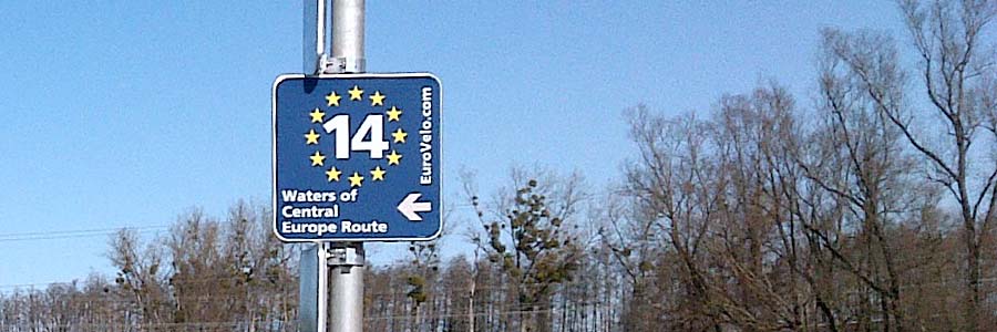
Im Frühjahr ist mir im Burgenland eine neu ausgeschilderte Radroute aufgefallen, der EuroVelo 14 “Waters of Central Europe Route”. Daraufhin habe ich die Relationsstrukturen des EV14 in OSM angelegt und die bestehende Teile in Ungarn und den neuen Teil im Burgenland eingefügt. Die Teile in Salzburg und der Steiermark blieben leer, da sie nicht ausgeschildert waren.

Wenig überraschend dauerte es nicht lange und die Lücken waren geschlossen. Meine Frage an den Mapper, welche Quelle er benutzte, beantwortete er mit entwaffnender Offenheit:

… The GPX of the EuroVelo routes can be downloaded publicly from the EuroVelo website (https://www.eurovelo.at/en) … I have no ‘ground’ knowledge of the EV14. My only goal is to have the route mapped completely such that cyclists from all over the world can enjoy it, which is the goal of the European Cyclists’ Federation. …

So sympathisch die Motive sind, so gibt es doch einige Problempunkte, die ich exemplarisch an diesem Fall ansprechen möchte.

See full entry

«Дружеская компания» - осенняя сессия семейных волонтерских команд в рамках Марафона полезных дел ![https://vk.com/okcm_okcm?w=wall-156078047_1203]

Location: Нижняя Согра, Абакан, городской округ Абакан, Хакасия, Сибирский федеральный округ, 655015, Россия
Posted by pnorman on 3 November 2020 in English.

A common task with OpenStreetMap data in PostGIS is to convert polygons to points to place labels. For simple polygons, the centroid can be used, but some shapes like C-shaped polygons, the centroid can lie outside the polygon, so ST_PointOnSurface is used. This function guarantees the point returned is within the polygon.

The only issue with ST_PointOnSurface is that it throws an exception on some invalid geometries. This isn’t a problem with a database created by a recent version of osm2pgsql which only creates valid geometries, but for older versions or other data loaders it’s unacceptable. This has lead people to writing wrapper functions that check the validity or catch the exceptions, but I’ve seen no benchmarking of the various options.

To benchmark the options, I loaded the planet data from 2020-10-12 and looked at named water polygons - those that matched ("natural" = 'water' OR waterway = 'riverbank') AND name IS NOT NULL. To make the system better reflect a tile server under load, I set max_parallel_workers_per_gather to 0 and jit to off. I then ran the query EXPLAIN ANALYZE SELECT function(way) FROM planet_osm_polygon WHERE ("natural" = 'water' OR waterway = 'riverbank') AND name IS NOT NULL;.

I tested with ST_Centroid, ST_PointOnSurface, ToPoint from postgis-vt-util, a function that checked validity before calling ST_PointOnSurface, a function that caught the exception from invalid geometries, and a function that used ST_Centroid for polygons with 4 corners and ST_PointOnSurface otherwise. The definitions are at the end of this post.

Function Time
ST_Centroid 277s
ST_PointOnSurface 408s
ToPoint 575s
point1 568s
point2 409s
point3 409s

Parallelism

See full entry

Atendendo a pedidos, a partir de hoje você poderá enviar sua área a ser mapeada para o mapeia.space, uma das vantagens é um mapeamento mais detalhado de uma área e uma melhor organização para mapear áreas maiores, então vamos as instruções:

Usando o geojson

essa é sem duvida a maneira mais fácil de se criar uma área para se enviar acesse https://geojson.io/ e desenhe um polígono e baixe o arquivo como geojson esse método é recomendado para uma área personalizada

Usando limites administrativos

então queres usar limites administrativos para definir sua área?? no caso você terar que pesquisar o nome da cidade no OpenStreetMap ou relação, então copie o numero da relação e envie

Escolhido e definido sua área, antes de enviar você precisa

  • definir tags que apareceram nos comentários das alterações, apareceram como # então escolha palavras simples para definir sua tarefa
  • descrição é a parte que deve conter tanto o por que da sua tarefa existe como os objetivos dela, então seja descritivo, links para seu projeto se for o caso, e é claro na descrição é que vai conter toda instruções para que outros mapeadores possam fazer sua tarefa!!

depois de concluído todas esses pré-requisitos mande um e-mail com tudo gustavo22soares.gs@icloud.com

Bom Mapeamento!

Posted by bobwz on 2 November 2020 in English.

I’ve spent a fair amount of time looking for the “perfect” consumer device to be used in my on-the-ground surveys that provides better-than-average accuracy without spending thousands on survey-grade equipment. This article series is an attempt to catalogue my experience to those who are interested.

Before diving in, I’d like to review the obstacles to accuracy when surveying using GPS-enabled devices. While this subject may be common knowledge to those familiar, it took me a considerable amount of time to understand some of these points and was a major driving factor in my quest for the “perfect” device.

GPS vs. GNSS

Throughout this article I’ll use the term “GPS” to refer to the systems and satellites that provide longitude and latitude location information to a user. Please note that this is not 100% accurate, however, since “GPS” is a specific satellite (known as a “constellation”) location system among many. In fact, GPS is part of a general Global Navigation Satellite System or GNSS. Other GNSS systems are as follows:

  • GPS
  • GLONASS
  • Galileo
  • BeiDou

I’ll be using “GPS” in an attempt to minimize confusion to those (like myself) who were unfamiliar with this distinction until now.

Precision Limitations

In brief, GPS works by analyzing a time code that is continuously sent by satellites in orbit around Earth. Receivers take that time code from multiple satellites and determine how long it took for the receiver to receive the time code data. This information is then used to calculate a longitude and latitude location on Earth.

See full entry

Between 7 October and November 2020, a series of tropical cyclones and seasonal monsoons caused heavy rainfall, floods and landslides in Central Vietnam. About 230 deaths and 53 missing were reported in the national media.

With the help of Russell at HOTOSM, I created this project to contribute map data of the districts where the highest number of deaths occurred. These districts mainly lie in the mountainous part central region and therefore more prone to natural disasters. Although open to Beginner mappers, this is more accurately an intermediate difficulty mapping experience.

URL: https://tasks.hotosm.org/projects/9734

Help map flooded areas in Vietnam! Cyclone Molave brought heavy rains, widespread flooding and at least one major landslide to Vietnam.