Users' Diaries

Recent diary entries

Posted by ljc_jlyb on 10 August 2025 in Chinese (China) (‪中文(中国大陆)‬). Last updated on 28 July 2026.

延吉市 133000

133000市区(进学、新兴、北山街道)、小营镇东郊部分(光明、光进、小营、新光村)

133001市区(河南、建工街道)、小营镇南郊部分(东光、东新、东明、东风、仁坪、吉兴、新光、新农、河龙、理化、长东)

133002市区(公园街道)、小营镇西郊部分(民主、吉兴、果树村),依兰镇北郊延吉河以西部分(发展、大成、实现村)

133003依兰镇部分(原烟集乡下辖的兴农、利民、台岩、龙渊村)

133004依兰镇部分(原依兰乡的九龙、古城、平安、春光、东兴、北大、兴安村)

133005三道湾镇(镇区、五道、梨树、东沟、平岗村)

133006三道湾镇(南张芝、北张芝、屯田、支边村)

图们市 133100

133100市区、开发区

133101石岘镇(镇区、陆地、永昌、河北、春华、东兴、石岘…)

133102月晴镇部分(原月晴镇的笠峰村、水口村、杰满村、榆基村、马牌村、歧新村、石建村、白龙村)

133103长安镇全部、月晴镇碧水村

133104

133105凉水镇全部

汪清县 133200

珲春市 133300

龙井市 133400

133400市区、智新镇部分(明东村、智新村、

133401朝阳川镇部分(原朝阳川镇的镇区、三峰、三成、东丰、光荣、凤林、勤劳、合成、吉成、德新、朝阳、长青村)

133402老头沟镇部分(原铜佛寺镇的大马村、永胜村、泗水村、铜佛村、铜尚村、铜心村、铜西村、鹰岩村)

133403老头沟镇部分(原细鳞河乡的细鳞村、文化村、日新村)

133404老头沟镇部分(原老头沟镇的镇区、勇进村、大箕村、太阳村、奋斗村、官船村、官道村、宝兴村、廉明村、新成村、桃园村、老西村、龙水村)

133405老头沟镇部分(原天宝山镇的天宝社区、新成村)

133406原为长安镇邮编,现用133103

133407朝阳川镇部分(原太阳镇下辖的仲坪、太兴、柳新、横道、龙盛村)

133408朝阳川镇部分(原八道镇的八道、平道、长胜村)

133409原为三道湾镇邮编,改用133005

133410无资料

133411原为三道湾镇南张芝、北张芝、屯田、支边村邮编,现统一使用133006

133412原依兰乡,改用133004

133413无资料

133414东盛涌镇(原东盛涌的镇区、龙山村、平安村、东盛涌村、延东村、东明村、勇成村)

133415东盛涌镇部分(原石井乡的石井村、龙山村、龙河村)

133416德新乡全部

133417开山屯镇全部

133418无资料

133419三合镇(镇区及三合、北兴、鹤栖村)

133420空号

133421三合镇(富裕村)

133422原为白金乡勇新村

133423白金乡(白金村、平顶村、勇新村)

和龙市 133500

133500市区(人民大街邮政支局、同心路邮政支局、丰民路邮政支局、河西邮政支局、海兰邮政支局、春化邮政支局);龙城镇部分(牛心村、太平村、…)

133501东城镇全部

133502头道镇部分(原龙水镇的江南社区、龙海村、龙湖村、新民村、龙源村、龙水村)

133503头道镇部分(原头道镇的江北社区、延安村、明兴村、三河村、龙坪村、龙新村、广新村、新北村、镇兴村)

133504头道镇部分(原龙门乡的龙门村、青龙村、长仁村)

133505八家子镇全部

133506西城镇部分(原西城镇的新城社区、金达莱村、二道村、龙浦村、城南村)

133507西城镇部分(原卧龙乡的甲山村、卧龙村、和安村)

133508福洞镇全部

133509龙城镇部分(原土山镇的土山村、官地村、水南村、五明村、和兴村、源河村)

133510南坪镇部分(原勇化乡的高岭村、兴化村)

133511空

133512南坪镇部分(原德化镇的友谊社区、南坪村、龙渊村、柳洞村、车厂村、高产村)

133513南坪镇部分(原芦果镇的芦果村、龙坪);崇善镇部分(原芦果乡的竹林村、兴南、梨树、土城)

133514崇善镇部分(富民社区、大洞村、古城村、上天村)

133515龙城镇部分(工农村等)

Transjakarta, jaringan rute Bus Raya Terpadu (BRT) terpanjang di dunia ini menjadi tulang punggung transportasi umum di dalam Kota Jakarta. Dengan ratusan rute dan ribuan kendaraannya, Transjakarta menjadi bagian penting dalam identitas Kota Jakarta. Namun sayangnya, data rute dan infrastruktur pendukung Transjakarta kurang diminati untuk dipetakan. Hal ini mendorong saya untuk memetakan Transjakarta, setidaknya jaringan koridor utamanya terlebih dahulu.

Mengenal sistem Transjakarta

Transjakarta merupakan sistem jaringan bus kota di Jakarta. Ditinjau dari rutenya, rute Transjakarta terbagi menjadi dua, yakni rute BRT dan non-BRT. Rute BRT merupakan rute yang berjalan sepenuhnya di jalur khusus dan hanya berhenti di halte BRT. Sementara itu, rute non-BRT merupakan rute bus kota yang melayani halte di pinggir jalan dan biasanya tidak melewati jalur khusus. Sebagian kalangan membagi lagi rute non-BRT menjadi rute non-BRT yang juga melayani halte BRT dan rute yang sama sekali tidak melayani halte BRT (sepenuhnya melayani halte biasa di pinggir jalan).

Jalur khusus yang dimaksud pada kenyataannya tidak benar-benar “khusus”. Sebagian jalur khusus memang memiliki pembatas atau separator untuk memisahkan jalur untuk bus dan kendaraan lain. Namun, sebagian lainnya hanya berupa jalan yang diberi marka, sehingga pada kenyataannya juga dipakai oleh kendaraan lain. Sebagian lainnya bahkan tidak memiliki penanda apapun, sehingga bus “BRT” berjalan di jalan yang tidak memiliki perlakuan khusus apapun terhadap bus Transjakarta.

See full entry

Location: RW 04, Gambir, Jakarta Pusat, Daerah Khusus Ibukota Jakarta, Jawa, 10110, Indonesia

This is a compilations of what I sent to other people.

I have taken it from the cadastre at (https://seduvi.cdmx.gob.mx/programas-delegacionales-de-desarrollo-urbano), I was extremely surprised that CDMX’s cadastre has not being used because it is in the public domain (“Este programa es de carácter público, no es patrocinado ni promovido por partido político alguno y sus recursos provienen de los impuestos que pagan todos los contribuyentes.”) You only need to credit the source: “Agencia Digital de Innovación Pública “Sistema Abierto de Información Geográfica (SIGCDMX)” Disponible en: https://sig.cdmx.gob.mx/”.

After reading osm.wiki/Import/Guidelines, I will make a import page for CDMX data to serve as a documentation for where the data comes from.

Step 1

I download the data from (https://sig.cdmx.gob.mx/datos/descarga). There are two types of data there, the actual cadastry data “Descarga de datos del catastro” and landuse data “Descarga de datos SEDUVI”. The cadastry data is basically a bunch of points and I find that the only useful data there is the address data, which is fairly inaccurate.

It is better to download the landuse data since it has the polygons to work with. I download the shapefile from the “Descarga de datos SEDUVI” section. I’m working at Cuauhtémoc alcadia because it is the central alcadia of CDMX

Generally, since houses in Mexico are connected to each other, often the landuse is the building footprint itself. But, for more complex places like schools, churches, hospital, government areas, etc. it only covers the surrounding of the complex.

Step 2

See full entry

Posted by Dokdo on 10 August 2025 in Korean (한국어).

한국어

저는 건물 중 2층에 난간을 생성하고 싶었는데, f4map demo에서 보니 난간이 엉뚱하게 1층에 생성되어 있었습니다. 2층에 난간을 생성하려면 어떻게 해야 하나요? (참고로 2층은 테라스입니다) 참고 사진: https://ifh.cc/v-x6kwaD

English(by Google translator)

I wanted to create a railing on the second floor of a building, but in the f4map demo, the railing was created on the first floor. How can I create a railing on the second floor? (For reference, the second floor is a terrace.) Reference photo: https://ifh.cc/v-x6kwaD

Location: 산하동, 북구, 울산광역시, 44264, 대한민국
Posted by WilliamHarrison on 9 August 2025 in English.

Hello!
I’ve been mapping in OpenStreetMap for a few years now, and I believe the current method of mapping routes is quite painful and wastes hours of editors’ times to just upkeep it, So, here is my idea on how we could fix it.


The Idea

In essence, it is to have just one start node and one end node, the router (using the bus profile) then calculates the route deterministically, with additional points in between added only as needed to achieve the desired path.

For example, in the case above, the route can be simplified from 123 ways down to just 5 nodes representing the path. (In reality there would be nodes at every station, so it wouldn’t be as few as 5)

This approach is;

  • Resilient to edits,

  • So many times easier to maintain.

Demonstration image showing 5 nodes representing a bus route. I’ve compiled Valhalla on Linux and created a quick proof of concept program showing this can already be implemented (unofficially) in custom code.

See full entry

Posted by Rivai Sigit on 9 August 2025 in Indonesian (Bahasa Indonesia). Last updated on 16 August 2025.

Riau: Empat Sungai Raksasa

Pembukaan

Dua hingga tiga abad sebelum kita mengenal provinsi yang bernamakan Riau, dahulu para pelaut mengetahui daerah ini sesuai dengan nama sungai besar yang ada. Sungai Rokan, Siak, Kampar, dan Indragiri, terkenal dengan sumber daya yang mereka bawa ke berbagai pusat perdagangan di Selat Melaka. Kedatangan Portugis ke Melaka dianggap sebagai titik mula nama ‘Riau’ terdengar, karena kata ‘Sungai’ dalam bahasa Portugis adalah ‘Rio’. Mungkin penjajah Portugis pada zaman itu tidak bisa mengucapkan nama-nama sungai tersebut dengan baik, dan perubahan simpel dengan merujuk mereka sebagai ‘orang-orang sungai’ lebih mudah bagi mereka untuk diingat.

Tiap sungai ini mempunyai sejarah & ciri khas-nya tersendiri, dan diary ini akan mencoba untuk menjelaskan secara singkat tentang keberadaan empat sungai besar yang ada di Riau.

Rokan: Sungai Kejayaan

Sungai Rokan

See full entry

Posted by Brazil Singh on 8 August 2025 in English. Last updated on 12 August 2025.

Brazil Singh My OSM Wiki

About Me

I am Brazil Singh, an open mapping advocate, digital innovator, web developer, and community leader from Bangladesh. As an Open Mapping Guru at the Open Mapping Hub Asia-Pacific, I equip communities with practical and impactful mapping skills. I play a key role in managing social media for the OSMF, and actively contribute as a volunteer in the OSMF Local Chapters and Communities Working Group (LCCWG).

As a dedicated mapper, trainer, community organizer, and advocate, I have worked with the OSM ecosystem at local, regional, and international levels. From mapping in flood-affected areas of Thailand to mentoring YouthMappers across Asia and beyond, to volunteering with HOT and the OSMF Communication Working Group, I have seen firsthand how collaboration can create meaningful impact.

See full entry

Posted by Mannivu on 8 August 2025 in Italian (Italiano).

Ho creato un breve video per spiegare come indicare le corsie, le corsie di svolta e le corsie dedicate al trasporto pubblico locale su OSM. Nel video spiego come farlo usando iD, JOSM e Vespucci (purtroppo non ho accesso all’ambiente iOS, quindi non ho potuto fare alcun video in quell’ambiente). Il video è caricato su Wikimedia Commons, ma sono molto incerto sulla licenza che ho utilizzato, quindi finché è online lo potete trovare in

https://commons.wikimedia.org/wiki/File:Corsie_su_OSM.webm

Se in futuro verrà cancellato, capirò se e come ricaricarlo su un’altra piattaforma.

OBRA COLETIVA SERÁ LANÇADA NO III WORKSHOP MAPEAMENTO PARTICIPATIVO E CARTOGRAFIA SOCIAL - MPCS 2025


Read in English

O livro Estudos de caso em mapeamentos colaborativo e participativo é uma obra coletiva, organizada pela Dra. Raquel Dezidério Souto, que integra 20 capítulos com relatos de pesquisas que adotaram metodologias de mapeamentos coletivos - colaborativo ou participativo e de cartografia social, nas cinco regiões do Brasil e com os mais variados fins, desde a conservação da Natureza, passando pelo reconhecimento das comunidades tradicionais, o inventário da infraestrutura urbana e a valorização do patrimônio histórico-cultural. Esperamos que a sua publicação lance luz sobre a importância e aplicabilidade dessas metodologias e contribua para expandir a rede de conhecimento, em torno dessa temática.

O lançamento do livro já tem data: 29 AGO 2025, 16h (UTC-3), com transmissão pelo canal IVIDES no YouTube

O programa completo do Workshop MPCS 2025 já está publicado nesta direção

Nos veremos em agosto, no evento 100% online e completamente aberto ao público. As inscrições podem ser realizadas na página do evento

See full entry

BOOK RELEASE IN THE III WORKSHOP ON PARTICIPATORY MAPPING AND SOCIAL CARTOGRAPHY - MPCS 2025


Ler em português

The book “Case studies in collaborative and participatory mapping” (original Estudos de caso em mapeamentos colaborativo e participativo) is a collective work, organized by Dr. Raquel Dezidério Souto, which includes 20 chapters with reports on research that adopted collective mapping methodologies - collaborative or participatory and social cartography, in the five regions of Brazil and for a wide variety of purposes, from nature conservation to the recognition of traditional communities, the inventory of urban infrastructure, and the enhancement of historical and cultural heritage. We hope that its publication will shed light on the importance and applicability of these methodologies and contribute to expanding the network of knowledge around this theme.

The book release date has been set: August 29, 2025, at 4 p.m. (UTC-3), with live streaming on the IVIDES YouTube channel

The complete schedule of the Workshop MPCS 2025 is now available here.

See you in August at this 100% online event, which is completely open to the public. The registration is available on the official website

See full entry

Posted by alan_gr on 8 August 2025 in English. Last updated on 17 August 2025.

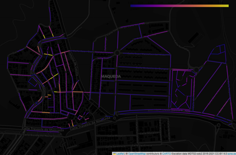
Map of the Maqueda barrio in Malaga, showing streets colour-coded by estimated gradient, on a dark background

This image shows the Maqueda barrio in Malaga, with streets colour-coded by estimated gradient. The flat area to the east shows up with cold colours, while the western part of the barrio, which straddles a ridge, generally has warmer colours. But why did I make this map, and what does it have to do with “streets that are really steps”?

In my wanderings around the city of Malaga, I have often come across flights of steps that are not tagged as highway=steps in OpenStreetMap. Usually they are tagged as residential or footway, with misleading results for anyone using OSM-based maps or routers to find their way around the city.

See full entry

Location: 36.735, -4.568
Posted by shetto on 7 August 2025 in English.

I started mapping on 7 of August using StreetComplete. I discovered (unfortunately) that I understood some criteria concerning road smoothness wrong, and I was no longer sure if my edits from the first day were correct, so I decided to delete most of them, to remap and do it properly. Furthermore, I apologize if anyone had any inconvenience of my poor first mapping steps.

I will stick to mapping and hope to improve in the future. :)