
Today I mapped a village named Vesqi located in Baldushk, close to the capital.
I did not know there was a reservoir in Baldushk so another one to visit added to my list.
“#100villagesin100days #day23”
 OpenStreetMap
Today I mapped a village named Vesqi located in Baldushk, close to the capital.
I did not know there was a reservoir in Baldushk so another one to visit added to my list.
“#100villagesin100days #day23”
Today I mapped the tiny village of Kaftall.
Kaftall does not have many houses, but they are spread all around the hill in quite a big area.
I also moved around a little and mapped some building on the surrounding areas.
“#100villagesin100days #day22”
In new version of userscript, I focused on analyzing edits. QuickLook for changesets, hotkeys, filtering changesets, mass actions and more.
Help wanted: I would be grateful if someone knows how to get into the site code and manage the map (add new objects, change layers, colors …) This would make it much easier for new features to appear. Otherwise, they will only be available in OSM-NG (: upd: solution found!
Now you don’t need to open OSMCha for simple changesets. Tag changes will be visible directly on the changeset page.
I started my journey as an OSM contributor in August 2018. My knowledge was initially limited to the iD editor and HOT tasking manager platform, with minimal community mapathon contributions within Nigeria. Consequently, my contributions to OSM were very low and inconsistent.
In November 2023, while seeking more opportunities to volunteer and contribute to the growing OpenStreetMap community, I discovered the OM Guru fellowship organized by the Open Mapping Hub Asia-Pacific. I applied as a Mapper, which complemented my background as a Remote Sensing and GIS student.
During my six-month tenure in the fellowship, I was exposed to various aspects of mapping, from building data capturing using JOSM, to Amenities/POI mapping with Every Door, and street-level imagery capturing using Mapillary, focusing on Disaster, Humanitarian, and Climate action. Additionally, I learned and developed my skills in JOSM validation and field mapping. The weekly training sessions and webinars exposed me to more applications of GIS and Remote Sensing in open spatial data science, thus enhancing my geospatial expertise.
One significant highlight of the fellowship was the Climate Change Challenge, where OM Guru-led groups competed in 8 climate challenges. I led a team of OSM contributors, which provided me with valuable leadership and teamwork experience. I was exposed to more applications and tools within the OSM ecosystem, such as Mapswipe, Maproullete, and mapping with RapidID. I contributed to mapping high priority, disaster prone and impacted areas in Asia-pacific countries.
I can’t save the changes. It shows error instead
Travelling to Thessaloniki today and got a 10-hour bumpy bus drive ahead.
Mapping while travelling by bus is definitely a huge challenge, but I think I managed to map Hajdaraj.
I think the village includes another area close to it, but somehow it is separated in a different residential area. Ill double check to make sure I got it all.
“#100villagesin100days #day21”
Práce, úpravy, pot, a únava. Když lze spatřiti tu tmu na konci tak lze nalézt světla u té lampy ke koši vzdálené u mostu starého, tam daleko od hory mezi kopci hledící do údolí, vidím tu vodu téct, tam kam už se nikdo nepodívá. Tam kde jsem spatřil jiskru mého citu.
Welcome to the twelfth OpenStreetMap NextGen development diary.
This week brought some exciting updates and major news!
🔖 You can read my other development diaries here:
osm.org/user/NorthCrab/diary/
⭐ This project is open-source and publicly available:
https://github.com/Zaczero/openstreetmap-ng
🛈 This initiative is not affiliated with the OpenStreetMap Foundation.
We are now welcoming new contributors! To show our appreciation, we offer contributor incentives. If you’re familiar with Python, join us – it’s easy to get started!
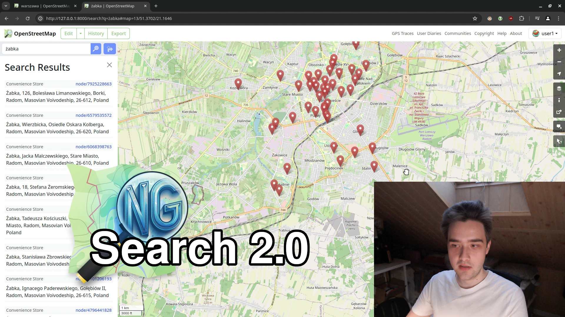
This week, we made significant strides towards our NextGen vision. The new search functionality is nearly complete, and I’ve recorded a short video comparing OSM Ruby and OSM-NG side-by-side.
⬇ Click below to play ⬇
or click here: https://peertube.monicz.dev/w/c7Qwif6S4MpvuBBDu7x8LM
Na oficina, foram abordados: conceitos importantes de mapeamento colaborativo, modelo de dados, editores e aplicativos para dispositivos móveis, download e upload de dados; e demonstração de uso do editor iD e dos plugins do QGIS (OSMDownloader, QuickOSM e QuickMapServices).
Os arquivos da oficina e um roteiro para pŕatica estão disponíveis em português, na pasta virtual.
At the moment I’m only doing small edits, or edits using StreetComplete. I got frustrated by some people making bad edits which persuaded me there were other things that I could do rather than editing OSM.
Particularly annoying behaviours for me:-
My main goal with editing OSM is to improve route planning on foot, bicycle, or public transport, hence why I’m keen to get surface, tracktype, smoothness, access, and construction tags correct.
I can not believe it that it has already been 20 days into the challenge and I have mapped over 30 villages so far. For the next five days I will be in Thessaloniki with a group of Wikimedians from the Balkans and I hope I manage to map every day, but if I don’t, I promise I will catch up.
If somebody following this want to catch up and learn or contribute to enriching Wikipedia, Commons and Wikidata from 26 to 30 June, reach out and ill let you know where you can find us.
Today I mapped Perkola and the surroundings. Perkola was partially mapped, so I moved around the map and mapped some other areas too.
“#100villagesin100days #day20”
We have started to export and upload contribute all the GPS Routing Data we have collected from our motorcycle 360* data recorder for [Vietnam Street View project] (https://streetview.vn).
Check our our Trace History upload in here: (osm.org/user/openmap-vn/traces).
The data we contribute will partly support the construction of the navigation process for projects using the open map OSM.
We all know that you should never map for the renderer and you should only map what is on the ground. But I think I’ve found the third sin, changing the ground to match the map. This nine year old way is a service lane with a name, but doesn’t give a source for the name. Doing a survey showed no signs and historic photos show it as without signs. So I contacted the local council, City of Charles Sturt and asked if they could erect signs, which they have.
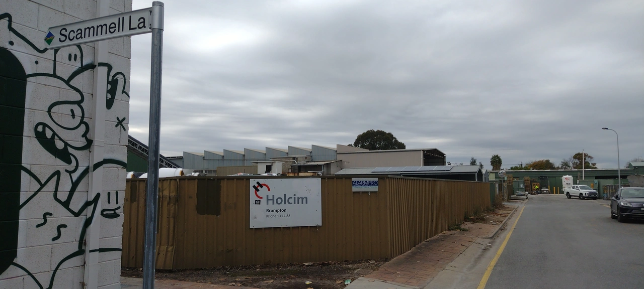
I don’t feel the least bit guilty. 😊😊😊
Today I mapped Leminot a village with a population of 860, in Korçë.
“#100villagesin100days #day 19”
Walked into town and along seafront down to Lancaster Gardens.
dsx dc fce qd
Good news! Heavy goods vehicle and HGV have been accepted into the Oxford English Dictionary as of this month. Now that these are proper British English words, we can finally tag all those truck restrictions we’ve been holding off on.
The Creative Commons Zero (CC0) waiver is, in my opinion, the most free way to release open-source software. Unlike licenses that impose conditions on the use, modification, or distribution of software, CC0 allows me to waive all my rights to limit what users can do with the software. It effectively places the work in the public domain. This absolute waiver ensures that the software can be freely used by anyone, for any purpose, in any way. Here’s why I choose CC0 when releasing open source software and why I cannot – and will not – grant permission to use my CC0 software.
Other licenses impose various requirements on using software, such as:
In contrast, CC0:
This complete freedom fosters innovation, as developers can build upon CC0-waiver software without worrying about legal ramifications or compatibility issues with other licenses.
That means:
I started my journey in OSM Mapping contribution in September 2020. I have worked in multiple OSM HOT Tasking projects in ID editor and JOSM. The community has been a blessing for me as it was more engaging and conscious of OSM mapping and having a journey making the world a better place through OSM Mapping.
At the end of December 2023 Open Mapping Hub- Asia Pacific hosted a program call to all active contributors to embark on a journey with AP-Hub of fellowship of active mapping and community engagement with AP-Hub network and OSM community. I passed the exam with joyous remarks. I was selected for Mapping track out of 15 been selected for the Mapping Track of OM Guru Fellowship. There was 3 different track set by AP-Hub, one Mapping track (tasked for mapping), 2nd Validation Track (tasked for validation of OSM Mapping), and 3rd Training track (Tasked for training participants). On first month, we had 100 task mapping in HOT Tasking Manager. It was a rigorous mapping in Philippines, Vanuatu and Micronesia. On 2nd month, we have worked on Everydoor App POI collection. I have roamed around my neighborhood to taking detailed data of the POIs. On the 3rd month March 2024, we worked on Mapillary of 500 images. Then on 4th month April, we worked on QGIS mapping, before and after image of OSM Mapping and 100 mapping tasks in HOT Tasking Manager. On 5th month May 2024, we validated 200 tasks in HOT Tasking Manager.
The entire journey had made me a consistent mapper and having learnt many new applications to contribute to OSM Mapping, I am grateful to AP-hub for the amazing opportunity.
5 Jahre - und ein paar Tage, habe selber viel zu tun momentan - sind es schon her, seit dem ich mir ein Account auf OpenStreetMap angelegt habe. Für mich fühlt es sich eher wie 20 Jahre an, weil sich so viel verändert hat, sowohl bei mir, als auch in der Welt um mich herum. Ich weiß aber noch, warum ich damit angefangen habe und wo ich stand zu dem Zeitpunkt.
In dieser Zeit finge ich ernsthaft an, mich mehr und mehr für Datenschutz zu interessieren. Davor hatte ich dieselben Medien benutzt, die die meisten benutzen würden - ein stinknormales Android mit Google-Account und WhatsApp, für E-Mails vertraute ich GMX und die sozialen Netzwerke meiner Wahl waren YouTube und Twitter (letzteres heißt mittlerweile X, da E. Musk diesen Buchstaben so sehr liebt wie er selbst). Über den Kuketz-Blog bin ich erstmals auf OpenStreetMap gestoßen. Die Datengrundlage in meinem Wohnort war aber recht alt zu dem Zeitpunkt und nach einiger Wartezeit kam ich zum Entschluss, selber anzupacken, da sich die Lage nicht verbessert hatte.
In dieser Zeit hat sich viel bewegt - sowohl in der OSM-Community als auch außerhalb. Ich habe aber aus persönlichen und gesundheitlichen Gründen kaum mit der Community interagiert, sondern eher meine eigenen Sachen gemacht. Jedoch haben wir uns dennoch ohne große Kommunikation gegenseitig geholfen.
Die meisten Edits waren eher kleiner und spontaner Natur, aber ich hatte auch einzelne größere Projekte durchgeführt:



.png)


