 OpenStreetMap

Highway, Building, Barrier, Tower, Area, Landuse, and more.
Users' Diaries
Recent diary entries
if you history user of 2 years form highways this finding. was edit errors has been yandex map.
Posted by ZeLonewolf on 30 April 2024 in English.
Last updated on 2 May 2024.

There is a long discussion happening in the United States section of the community forum regarding where to draw the line between the “main” populated place node values, and specifically the place=* values of city and town in New England. I thought it would be useful to do a bit of analysis to see how these values are distributed across the database when compared to population. Through this analysis, I include all tags which have place values of city, town, village, hamlet, and isolated_dwelling. I also only include nodes that have a population tag.
My overpass query for each category looks like this:
[out:csv(::id,place,population;true;"|")][timeout:60];
node[place=city][population];
out;
One of the challenges of analyzing this key is that because it represents order-of-magnitude differences, its distribution is log-normal. In other words, it forms a bell curve provided that the X-axis is drawn logarithmically.
To look at this data logarithmically, I grouped the place nodes logarithmically, in steps of 1, 2, and 5 per 10x jump. When viewing the distribution of place=town, the log-normal shape comes out quite clearly. The number on the X axis represents the upper limit of each bin.
Posted by Raquel Dezidério Souto on 30 April 2024 in Portuguese (Português).
Last updated on 2 May 2024.

✔ Oficina sobre criação de web map com uMap e dados do OpenStreetMap
✔ Palestra sobre criação de web map com uMap e dados do OpenStreetMap
✔ Oficina sobre importação de pontos de interesse (POI) no OpenStreetMap
✔ Mini curso para a Defesa Civil (Brasil)
✔ Oficina sobre mapeamento de pontos de interesse (POI) com OpenStreetMap
✔ Special interview about Brazilian NSDI on the first anniversary of YouthMappers UFRJ
✔ Entrevista especial sobre a INDE no aniversário de 1 ano do YouthMappers UFRJ
✔ YouthMappers UFRJ receives the Women’s Participation Award!
✔ YouthMappers UFRJ recebe o Women’s Participation Award!
✔ Our participation in the Open Data Day YouthMappers at UFBA 2024
✔ Nossa participação no Open Data Day 2024 do YouthMappers at UFBA
✔ Web map do mapeamento colaborativo para redução de riscos e desastes (RRD)
✔ Web map of colaborative mapping for the Disaster Risk Reduction (DRR)
✔ Mapear POI no OpenStreetMap e exibir dinamicamente com uMap
✔ Mapping POI in OpenStreetMap and displaying dynamically with uMap
✔ V Olimpíada Brasileira de Cartografia incluiu o OpenStreetMap como parte de sua etapa prática
✔ V Brazilian Cartographic Olympiad included OpenStreetMap as part of its practical stage
Posted by Raquel Dezidério Souto on 30 April 2024 in Brazilian Portuguese (Português do Brasil).
Participação no Festival Latinoamericano de Instalação de Software Livre - FLISoL Rio 2024
A Dra. Raquel Dezidério Souto, presidenta do IVIDES.org® e do YouthMappers UFRJ, ministrou palestra na edição carioca do FLISoL 2024, sobre Web map com uMap e OpenStreetMap, abrangendo os assuntos:
-
Conceitos básicos relacionados ao web mapping;
-
Características, modelo de dados, licença, acervos de dados, conversores, editores, APPs do OpenStreetMap;
-
Características do uMap, suas vantagens e limitações;
-
Estudo de caso - Web Map da Infraestrutura para Redução de Riscos de Desastres (RRD) no Município de Maricá (Rio de Janeiro, Brasil).
Todos os arquivos da apresentação podem ser encontrados na pasta virtual, que inclui a cópia do vídeo.
O vídeo da sessão pode ser encontrado também no canal do IVIDES.org® no YouTube.
Um agradecimento especial ao público participante ao vivo e aos(às) espectadores remotos! Agradecemos ainda aos(às) organizadores(as) do FLISoL Rio 2024, que contribuem para a disseminação do Software Livre na nossa cidade!
IVIDES.org® é uma marca registrada. Para entrar em contato sobre esta ação: ivides@ivides.org.
Posted by mvogelsteller on 29 April 2024 in German (Deutsch).

OpenStreetMap (OSM) ist ein kollaboratives Projekt, das es Nutzern ermöglicht, Karten und geografische Daten frei zu bearbeiten und zu nutzen. Dieses „Wikipedia der Kartenwelt“ bietet detaillierte Informationen zu geografischen Standorten und lokalen Ressourcen, die von einer aktiven Gemeinschaft aus freiwilligen Kartografen ständig aktualisiert werden.
Verbesserte Sichtbarkeit für Arztpraxen
Einer der größten Vorteile von OpenStreetMap ist die erhöhte Sichtbarkeit, die es Arztpraxen bietet. Durch die Registrierung ihrer Praxis auf OSM können Ärzte und Ärztinnen sicherstellen, dass sie von potenziellen Patienten leicht gefunden werden. Dies gilt für allgemeinmedizinische Hausärzte ebenso wie für spezialisierte Fachärzte wie Zahnärzte, Hautärzte, Gynäkologen, Urologen, Chirurgen, Psychiater, Neurologen, Augenärzte, Kinderärzte und sogar Tierärzte.
Routenplanung und Erreichbarkeit
Für Patienten ist es oft eine Herausforderung, den Weg zur nächsten Arztpraxis zu finden, besonders in unbekannten Gegenden. OpenStreetMap kann hier Abhilfe schaffen, indem es genaue und benutzerfreundliche Karten zur Verfügung stellt, die nicht nur die Lage der Praxis zeigen, sondern auch Informationen zu öffentlichen Verkehrsmitteln, Parkmöglichkeiten und barrierefreiem Zugang bieten. Dies verbessert die Erreichbarkeit und Patientenfreundlichkeit enorm.
Lokale Vernetzung und Community-Support
OpenStreetMap fördert nicht nur die individuelle Sichtbarkeit, sondern unterstützt auch die Vernetzung innerhalb der lokalen medizinischen Community. Praxen können leichter Kooperationen und Überweisungsnetzwerke mit benachbarten Fachärzten aufbauen, was insbesondere für spezialisierte Disziplinen wie Neurologen oder Psychiater von Vorteil sein kann.
Katastrophenhilfe und Notfallsituationen

[Semi-automated translation of the Italian diary entry]
On OpenStreetMap, a tree can be represented as a natural=tree node.
Leaf type 🌿
leaf_type is the most common tree-related tag in the database, this is because it is easily verifiable and is supported with a quest by StreetComplete. The values are broadleaved and needleleaved. Some argue that palms should not be tagged as broadleaved but with a value of their own, =palm.
Leaf cycle 🍂
This tag describes whether a tree is deciduous or evergreen. Most needleleaved tree species are evergreen, but this is not always the case, so do not infer this value automatically. You can add this value easily if you know the species, or more simply if it is autumn/winter. If not, you can try to see if satellite or street-level imagery taken at those times are available.
Genus and species 🌳
If you are not an expert, there are tools that can help you recognise the genus/species of a plant, such as Pl@ntNet and iNaturalist, both of which also exist as mobile apps. On OpenStreetMap there are many trees with species (or species:wikidata or species:xx) that do not have leaf_type or leaf_cycle. These values are of course identical for each species (and also for many genus) and can therefore be easily deduced. There are two lists on the OSM wiki that contain these values for genus and species.
MapComplete has a dedicated tree theme that can be used to enter the species while SCEE has a dedicated quest (“What is the genus or species of this tree?”).
Monumental trees 🏛️
Monumental trees can be mapped adding denotation=natural_monument. In Italy they are recorded by the Ministry of Agriculture, Food Sovereignty and Forests (Masaf) with annual updates. You can map them by adding ref:masaf, which is a unique code assigned by the ministry.
Su OpenStreetMap, un albero può essere rappresentato come un nodo natural=tree.
Leaf type 🌿
leaf_type é il tag maggiormente valorizzato nel database, questo perché é facilmente rilevabile (basta un’occhiata) ed é supportato con un’apposita quest da StreetComplete. I valori sono broadleaved (latifoglia) e needleleaved (aghifoglia). C’é chi sostiene che le palme non debbano essere taggate come latifoglia ma con un valore tutto loro, =palm.
Leaf cycle 🍂
Questo tag descrive la caduta fogliare, cioè se un albero é caducifoglio o sempreverde. La maggior parte delle specie di alberi aghifoglia sono sempreverdi, ma non é sempre così, non inferite quindi questo valore automaticamente. Questo tag é facilmente compilabile se conoscete la specie, o più semplicemente se é autunno/inverno. In caso contrario potete provare a vedere se sono disponibili immagini satellitari o foto a livello stradale scattate in quei periodi.
Genus e species 🌳
Se non siete esperti, esistono degli strumenti che possono aiutarvi a riconoscere il genere/specie di una pianta, come Pl@ntNet e iNaturalist, entrambi esistono anche come app mobile. Su OpenStreetMap esistono moltissimi alberi con species (o species:wikidata o species:xx) che non hanno leaf_type o leaf_cycle. Questi valori sono ovviamente identici per ogni specie (e anche per molti generi) e quindi possono essere facilmente deducibili. Sulla wiki di OSM esistono due liste che contengono questi valori per genere e specie.
MapComplete ha un tema dedicato agli alberi che può essere utilizzato per inserire la specie mentre SCEE ha una quest dedicata (“What is the genus or species of this tree?”).
Alberi monumentali 🏛️
Il Ministero dell’agricoltura, della sovranità alimentare e delle foreste (Masaf) ha censito (con aggiornamenti annuali) gli alberi monumentali d’Italia. Potete mapparli aggiungendo loro il tag denotation=natural_monument e ref:masaf. Quest’ultimo é un codice univoco assegnato dal ministero.
Posted by matthewsheffield on 28 April 2024 in English.
Last updated on 2 May 2026.
I’ve finished (for a second time!) mapping all the paths in my local cemetery. The first time another mapper decided that concrete or gravel ways designed for walking on weren’t “paths” and deleted them all. He also seemed to have strong feelings about people cycling in cemeteries, which is odd as The Greater Metropolitan Cemeteries Trust actually endorse it as a use of their land. As my daughter is buried in the cemetery I feel some ownership of the place, and do love it and Merlynston creek that flows through it. I’m hoping no one vandalises my work again.

I received a request to update my previous list of people who map every single day. The top 3 places remain the same, with Aurimas Fišeras passing the 10 year mark of non-stop mapping! Congratulations on an amazing accomplishment, and a big thank you to all of these dedicated mappers!
Posted by umbraosmbr on 27 April 2024 in English.

SotM Latam 2024 - Belém/Pará - Brasil.
The State of the Map Latam 2024 will take place in the city of Belém, Brazil, from December 6 to 8, 2024 at the Instituto Federal do Pará, this being the sixth edition of the ‘Latin American OpenStreetMap Conference’ and aiming to promote the use of OpenStreetMap (OSM), and the integration of OSM mappers, developers, open data communities, free and open source software communities, students, researchers, geoinformation professionals, non-governmental organizations, companies and public institutions.
SotM Latam 2024 After the voting period for choosing the SotM Latam 2024 logo has concluded, I am pleased to announce that the chosen option is 1.

Posted by busBR on 27 April 2024 in Brazilian Portuguese (Português do Brasil).

A Empresa Metropolitana de Transportes Urbanos de São Paulo (EMTU) anunciou um aumento significativo nas operações intermunicipais, adicionando 41 novas viagens em dias úteis em cinco linhas que servem diariamente cerca de 14 mil passageiros. A partir de 22 de abril de 2024, os usuários das regiões de Santana de Parnaíba, Francisco Morato, Jandira, Franco da Rocha e São Paulo experimentarão uma melhoria significativa na frequência dos serviços.
Detalhes da Ampliação do Serviço pela EMTU
As linhas metropolitanas que receberão os incrementos são operadas pela concessionária Anhanguera. Esta expansão inclui a adição de cinco novos ônibus, configurados para aumentar o conforto e a eficiência do transporte público nessas rotas.
A decisão de expandir as viagens foi baseada em um monitoramento contínuo e análises do Centro de Gestão e Supervisão da EMTU, que acompanha em tempo real a demanda e as operações dos ônibus.
Como Acessar os Novos Horários
Para os passageiros que desejam consultar os novos horários, a EMTU disponibiliza atualizações através de seu site oficial e pelo aplicativo para dispositivos móveis, disponível para iOS e Android.
Linhas com Incremento de Viagens
- Linha 852: Francisco Morato (Centro) para Santana de Parnaíba (Terminal Rodoviário da Fazendinha)
- Linha 346: Jandira (Jardim Nossa Senhora de Fátima) para Santana de 1. Parnaíba (Terminal Rodoviário Alphaville)
- Linha 352: Santana de Parnaíba (Cidade de São Pedro) para São Paulo (Lapa)
- Linha 216: Francisco Morato (Jardim da Alegria) para Franco da Rocha (Centro)
- Linha 386: Santana de Parnaíba (Várzea De Souza) para São Paulo (Pinheiros)
Sobre a EMTU


Years ago when searching for a viewpoint from an old photo where I wanted to do rail photography I managed to locate the exact cliffside overlook and discovered a somewhat hidden gem of trail network in the process.
Though there is an official dirt road in the canyon below and a few desire paths offshooting from it the hills above remained relatively unmapped not showing up in the otherwise void of an area.
With the understatement of the local forecast for the afternoon/evening I packed my beloved eTrex 20x in the camera bag along with my trusty Nikon D700 planning to take in some of the views while there in between tracing runs expecting no more than some cloudiness and a light sprinkling.
Posted by RicoElectrico on 26 April 2024 in English.

There are some object categories in OSM whose exact classification is often a matter of contention and edit wars. Main highways are one of the most prominent examples. There was a small edit war in Poland which resulted in no less than 4 blocks, but I did not let that crisis go to waste:
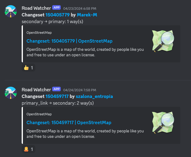
Behold road-watcher, a quick Python project that regurarly queries Overpass API for highway=secondary and above within a specified boundary and then detects any classification changes, sending them to a Discord channel (though it’s trivial to substitute it with another means of notification).
Posted by mvogelsteller on 26 April 2024 in German (Deutsch).
OpenStreetMap (OSM) hat sich als wertvolles Tool für viele Branchen erwiesen, darunter auch die Hotelbranche. Die Integration von OSM in die Online-Strategie eines Hotels kann dessen Sichtbarkeit und Suchmaschinenoptimierung (SEO) erheblich verbessern. In diesem Artikel erkunden wir, warum OpenStreetMap für Hotel-SEO wichtig ist und wie Hotels von dessen Einsatz profitieren können.
Erhöhte Online-Präsenz für Hotels
Einer der größten Vorteile der Nutzung von OpenStreetMap ist die verbesserte Online-Präsenz. Hotels, die auf OSM gelistet sind, erscheinen in einer Vielzahl von Map-Anwendungen und Diensten, die OSM-Daten nutzen. Das schließt beliebte Apps für Navigation und Reiseplanung ein, welche täglich von Millionen Nutzern verwendet werden. Diese erhöhte Sichtbarkeit kann dazu führen, dass ein Hotel von potenziellen Gästen leichter gefunden wird, was die Wahrscheinlichkeit von Buchungen erhöht.
Lokale SEO-Optimierung für Hotellerie
Lokale Suchmaschinenoptimierung ist für Hotels besonders wichtig. Wenn Ihr Hotel auf OSM gut repräsentiert ist, verbessert es die lokale SEO, da die Plattform von verschiedenen Kartendiensten und Suchmaschinen zur Datenverifizierung genutzt wird. Eine korrekte und detaillierte Darstellung in OSM hilft Suchmaschinen zu verstehen, wo sich Ihr Hotel genau befindet und welche Dienstleistungen es bietet. Dies ist entscheidend, wenn Nutzer nach Hotels in einer bestimmten Region oder Stadt suchen.
Kostenfreie und bearbeitbare Plattform
Im Gegensatz zu vielen anderen Kartendiensten ist OpenStreetMap kostenlos und von einer Community getrieben. Hotels können ihre eigenen Einträge hinzufügen oder bestehende aktualisieren, um sicherzustellen, dass die Informationen immer korrekt und auf dem neuesten Stand sind. Diese Aktualität und Genauigkeit der Daten ist für die SEO-Performance entscheidend. Durch regelmäßige Updates können Hotels ihre Sichtbarkeit in lokalen Suchergebnissen verbessern und sich positiv von der Konkurrenz abheben.
Posted by mvogelsteller on 26 April 2024 in German (Deutsch).
OpenStreetMap (OSM) ist mehr als nur ein Kartendienst im Internet: Es ist eine globale Gemeinschaft, die daran arbeitet, freie und editierbare geographische Daten für die ganze Welt bereitzustellen. Als leidenschaftlicher Verfechter der Bedeutung offener Daten und der Gemeinschaftszusammenarbeit möchte ich in diesem Blogartikel teilen, warum ich mich für OSM engagiere und warum ich glaube, dass auch Sie es in Betracht ziehen sollten.
Freie und Offene Daten
In einer Welt, in der geographische Informationen zunehmend kommerzialisiert werden, bietet OSM eine kraftvolle Alternative: Eine freie Karte, die von jedermann verwendet und bearbeitet werden kann. Diese Offenheit fördert nicht nur Innovation und Kreativität, sondern stellt auch sicher, dass diese wichtigen Daten dort verfügbar sind, wo kommerzielle Anbieter vielleicht kein Interesse haben zu investieren. Indem ich zu OSM beitrage, unterstütze ich ein Modell, das Wissen und Ressourcen demokratisiert, was meiner Überzeugung nach für eine gerechtere Welt unerlässlich ist.
Community und Zusammenarbeit
OpenStreetMap ist das Produkt einer engagierten Gemeinschaft von Freiwilligen rund um den Globus. Diese Gemeinschaft ist vielfältig: Sie umfasst nicht nur Kartographen und Geografen, sondern auch Menschen aus allen Bereichen des Lebens, die ihr lokales Wissen einbringen. Durch meine Beteiligung an OSM habe ich nicht nur die Möglichkeit, zur Karte beizutragen, sondern auch von anderen zu lernen und dauerhafte Verbindungen aufzubauen. Diese Zusammenarbeit auf globaler Ebene stärkt mein Gefühl der Zugehörigkeit und zeigt mir, dass meine Beiträge, egal wie klein sie sind, einen Unterschied machen.
Bildung und Empowerment
Posted by euroPathfinder on 25 April 2024 in German (Deutsch).

Am 24.04.2024 fand für die Touristiker des Saarlandes der zweite Teil eines Seminars zum Thema Route 3.0 & OpenStreetMap statt. Auf Einladung durch Klaus Wallach von der Tourismus Zentrale Saarland nahmen mit Barthwo und mir auch zwei saarländische Mapper an dem von Thomas Froitzheim durchgeführten Seminar teil. Motiviert wird das Seminar durch die neue Richtlinie Route 3.0 des Deutschen Tourismusverband (DTV).
Ziel des Seminars war es, die Touristiker mit dem Konzept OpenStreetMap bekannt zu machen und zur Kontrolle der richtigen Hinterlegung von Wander- und Radtourrelationen in OSM zu schulen. Dabei konnten die Touristiker sehen, dass sehr viele der Routen bereits von fleißigen Mappern in OSM hinterlegt wurden. Im Rahmen der Schulung kamen Tools wie BRouter-Web, GPX Viewer sowie WayMarkedTrails zum Einsatz. Anhand dieser Tools können die Touristiker nun:
- die aktuellen .gpx-Dateien bestehender Routen aus ihren Datensystemen mit den Relationen in OSM vergleichen, um fehlende oder fehlerhafte Relationen zu identifizieren, sowie
- ohne Vorerfahrung mit wenigen Klicks .gpx-Dateien erstellen, die bei kurzzeitigen temporären Umleitungen den Touristen zur Verfügung gestellt werden können.
Die meisten Touristiker kamen im Rahmen des Seminars zum ersten Mal mit der Datenstruktur von OpenStreetMap in Kontakt. Da das Anlegen oder Modifizieren von Relationen durch unerfahrene Nutzer viele Risiken birgt, wird eine Lösung unter Zuhilfenahme der Mapper-Community benötigt, anstatt den Touristikern das recht komplexe und zeitaufwendige Thema Relationen aufzubürden.
Posted by King edgar on 24 April 2024 in English.

The SMCoSE YouthMappers Chapter, renowned as one of Tanzania’s largest mapping communities, hosted a transformative mapathon on April 14, 2024, at the esteemed Sokoine University of Agriculture. This event marked a pivotal moment of collaboration, extending invitations to other YouthMappers chapters in Morogoro, thus amplifying the inclusivity and impact of the initiative. Central to the mapathon’s objective was the concerted effort to contribute to Project #15530 within the HOT Tasking Manager, focusing on mapping cities across the Eastern and Southern Africa Region. By leveraging the power of open data, participants aimed to craft detailed base maps crucial for diverse applications, ranging from urban planning to efficient disaster response strategies.
Amidst an atmosphere described as “fantastic,” the event witnessed a remarkable accomplishment, the successful mapping of approximately 25,000 buildings. This feat not only underscores the collective dedication of the participants but also showcases the tangible outcomes of community-driven endeavors. Moreover, the mapathon served as a platform for new mappers to acquaint themselves with essential mapping tools such as ID Editors and JOSM, empowering them to contribute meaningfully to the OpenStreetMap ecosystem.
Special recognition is duly owed to the Open Mapping Hub Eastern and Southern Africa (OMHESA) for their unwavering support, notably through the prestigious Spatial People Award. This acknowledgment not only highlights the significance of collaborative partnerships but also accentuates the pivotal role of organizations in facilitating impactful mapathons and community initiatives. In essence, the event epitomized the ethos of collaboration, learning, and contribution inherent within the mapping community, further advancing the cause of open data dissemination and spatial awareness in the region.
Posted by Beth Tapetes on 24 April 2024 in Brazilian Portuguese (Português do Brasil).

Beth Tapetes
Theatro da Paz, Belém/Pará - Brasil

O Theatro da Paz foi fundado em 15 de fevereiro de 1878, durante o período áureo do Ciclo da Borracha, quando ocorreu um grande crescimento econômico na região amazônica. Belém foi considerada “A Capital da Borracha”. Mas, apesar desse progresso a cidade ainda não possuía um teatro de grande porte, capaz de receber espetáculos do gênero lírico. https://www.theatrodapaz.com.br/
Credito da Foto; Wikipedia, https://pt.wikipedia.org/wiki/Wikip%C3%A9dia:Wiki_Loves_Par%C3%A1#/media/Ficheiro:Teatro_da_Paz_3.jpg Theatro da Paz, Belém/Pará - Brasil
