 OpenStreetMap

rt。此疑问是在补充长沙地铁3号线的名字时产生的。
百度百科采用的是“长沙轨道交通x号线”;
维基百科采用的是“长沙地铁x号线”和“x号线”;
长沙市各个总体规划文件上采用的是“长沙轨道交通”;
媒体大都采用“长沙地铁x号线”;
而长沙市轨道交通集团公司官网上,则既使用“长沙轨道交通x号线”又使用“长沙地铁x号线”,或者就只写“x号线”。
所以究竟哪个是正确的呢?在“长沙轨道交通x号线”、“长沙地铁x号线”、“x号线”三者中,osm应采用哪一个呢?
(目前osm中已标注线路名称采用的是“长沙地铁x号线”)
Users' Diaries
Recent diary entries
Posted by mappinglander on 16 August 2023 in Turkish (Türkçe).

- Başlamadan önce, eğer “kent rehberi”nin ne olduğu hakkında hiçbir fikriniz yoksa bora can’ın listesindeki sitelerden birkaçına girip bakmanızı tavsiye ederim.
Bildiğiniz üzere kent rehberlerini JOSM’de PicLayer gibi uygulamalarla kullanışlı şekilde görüntüleme (dikkatinizi çekiyorum sadece görüntüleme) biraz fazla zahmetli. Hızlıca bunun çözümüne geliyorum: Bunun için çılgınca bir şey denedim ve oldu. Harita altlıkları genelde WMS ve/veya WMTS veya benzeri formatta olur, standarttır. Ben de açıkçası “bence bu arkaplanda da bu şekilde, o zaman bu uygulamalar da çok özensizce yapıldığı için ben de web geliştirici araçları ağ kısmına veri transferini kaydedip bunları kolaylıkla bulabilirim.” diye düşündüm ve de ilginç bir şekilde bu varsayımım tuttu.
Türkiye’de “kent rehberi” denilen olayda kullanılan iki büyük yazılım var: ArcGIS (ki bu dünya çapında da yaygındır, bizde de çok yaygındır), Belsis üzerindeki uygulamalar (gerçi bunların çoğu da arkaplanda ArcGIS ya da NetGIS çalıştırır, NetGIS çalıştıranlarına IMS gibi bir şey deniyor. Burada NetGIS çalıştıranlarından bahsedeceğim) ve NetGIS (ArcGIS kadar yaygın değildir ancak bilinir, Türkiye’de KEOS da deniyor anlamadığım bir şekilde). Çünkü kimse tepeden tırnağa kendi yazılımını yazıp “debug”uyla ayrı uğraşmak istemez, onun yerine üstüne kendi arayüzünü çizer o kadar. Hatta bazı durumlarda bu arayüz o kadar çirkin oluyor ki uygulamayı kullanasınız gelmiyor. Bunun dışında GeoWebServer, CitySurf gibi daha küçük çapta kullanılan ya da tamamen özel olarak yapılmış uygulamalar da mevcut, bunlara girmiyorum. Bunların da bazıları bahsettiğim metotla kolayca halledilebilirken bazıları için imkansız gibi bir şey.
Harita altlığı çekme yöntemlerine gelirsek:
ArcGIS
Belki de uğraşması en kolay olanı. Genelde ayarlamalara dikkat edilmediği için https://(site)/arcgis/ şeklinde, sonrasında altlıkların her birine bakarak yukarıdaki seçeneklerden WMS veya bazen WMTS seçeneğiyle istediğiniz altlığı çekmek mümkün.

Over the past few days, my perspective on OpenStreetMap (OSM) has undergone a seismic shift. For the longest time, I held OSM in the highest regard, viewing it as a beacon of transparency and people-centricity amidst a sea of profit-driven tech conglomerates.
Chapter 1: The Banner of Surprises
My view started to waver a couple of days ago when a new donation request banner popped up on the main OSM page. Though its sheer size and prominence were unsettling, the real issue lay in the near-invisible close button. When I voiced concerns on its ready-for-production state, opposition awaited me on the other end. Was this a shift in OSM’s priorities?

Chapter 2: The Amazon Alliance
This entry was meant to test this Diary feature.
Sorry for the clutter.
Posted by Piotr Strębski on 15 August 2023 in Polish (Polski).
Last updated on 20 May 2025.


(Inspiracją dla tego wpisu w dzienniku był dla mnie trwający już ponad 3 lata kontakt ze strażakami z Jednostki Ratowniczo-Gaśniczej nr 1 w Suwałkach, których serdecznie pozdrawiam!)
Nawet najbardziej zaangażowanego kartografa serwisu OpenStreetMap (“mappera”) mogą z czasem ogarnąć wątpliwości czy znudzenie, u podłoża których stoi pytanie: “A tak właściwie, na co to komu?”. Czasem, poza osobistą satysfakcją czy osobistą nagrodą za włożoną pracę (w postaci możliwości wykorzystania w praktyce stworzonych przez siebie przed chwilą map = odwzorowania rzeczywistości), potrzebujemy po prostu czegoś więcej, poczucia sensowności społecznej a nie tylko indywidualnej (dla nas czy naszych znajomych). Każda więc informacja zwrotna ze strony np. służby straży pożarnej, że to co się robi ma sens i jest na co dzień przydatne i wykorzystywane w bieżącej pracy - to kop satysfakcyjny motywujący do dalszej pracy!
Posted by petrusko on 14 August 2023 in French (Français).
Last updated on 15 August 2023.

Découverte du Disc Golf, ou Frisbee Golf.
Du coup on rigole à ajouter un terrain de ce loisir/sport
osm.org/way/1198132418
avec les infos du wiki
osm.wiki/Tag:leisure%3Ddisc_golf_course

osm.wiki/File:Disc_golfer_and_basket.jpg
Have fun ;)
EDIT :

Hello everyone, I am here again with the 5th Blog of my journey as an Outreachy intern. For those who don’t know me , I am Neelima Mohanty , selected as an Outreachy intern at Humanitarian OpenStreetMap Team (HOTOSM) for the May to August Cohort. If you are new to my blog then make sure you read my previous Outreachy Blogs before going through this blog post.
This is the second last week of my Outreachy internship and I almost feel like I am a part of the HOT Community or in other words I feel like I know many members of HOT already. Apart from my mentors Rob Savoye and Petya Kangalova , the list of members whom I know are Kshitij Raj Sharma , Omran Najjar , Susmina Manandhar and Sam Woodcock . Informal chats with all these people made me more familiar with this community. Let me introduce all of them with you and what I have learnt from the informal chats with them.
Kshitij and Omran are part of the dev team for fAIr project of HOT . I learnt a lot from each one of them about backend and frontend of that project and understood their work to implement AI in the process of mapping .
I already have written about my interaction with Sam Woodcock in my 2nd Blog . But that was how we came to know each other for the first time . Whereas when I got selected as an Intern , he sent me a message introducing himself and told me that he would like to help me in my technical documentation work in FMTM if I face any issues . Then I came to know that he had been volunteering for FMTM since a long time.
And finally and very recently I met with Susmina Manandhar from Nepal who work as an Associate Project Manager at NAXA one of the partners of HOT . We together worked for two weeks and prepared the Lightning Talk Video of the FMTM project for Code for All summit. While in these two weeks , we met almost everyday and not just talked about work but she also shared about herself and her University days .

OSM is ChAozsz.
OSM is like an unprincipled anarchist society.
OSM is like an anarchic society with a broken system.
OSM is an anarchic society of absolute equality that has collapsed
Who can resuscitate the OSM ecosystem?

I had mapped my first mass path a little over two years ago and made a video about it: https://www.youtube.com/watch?v=JyxYRqNG6aI. I’m revisiting the topic now for reasons I will get into.
What is a mass path?
In Ireland, mass paths are either footpaths people used to walk to church or - more often - to school (because the school tended to be very close to the church). Those mass paths are basically short cuts across fields and were used until the 1960s or thereabouts. The other type of mass path dates back to the times of the Penal Laws, when Catholics were forbidden to go to mass (and to school). They met at secret locations, mass rocks or mass pits, to celebrate mass. The went out of use with the end of the Penal Laws.
Why my re-awakened interest?
My local county council had wanted to start a project to record mass paths in the county, and I considered applying for it, but I could not meet their conditions (driver’s license, insurance). This was regrettable, because I could have assembled the perfect team, but it was not possible for us. However, thanks to determination and OpenData platforms like OSM and Wikimedia, it doesn’t mean we can’t record some of them.
Methodology
Today I spent half the day in the forest near Bahrdorf to prepare an orienteering map in OOMapper. First I downloaded the OSM data into the app, then set out with a tablet computer as well as fieldpaper, pencil and compass to add all the features necessary for orienteering. There are of course lots of details to attend to, but I want to write about the role of OSM in orienteering mapping today.
For a forest map that I set up from scratch, OSM data come in handy because they provide a georeferenced basemap to start from. But other than that, 99% of the orienteering map is my work, and there is not much in what I do that is of interest for OSM (except the odd information board or a path that has disappeared).
Things are quite different when it comes to sprint orienteering maps, which mostly show parks and urban areas. The availability of OSM data was a real game changer here, because we used to draw all the building outlines by hand. For a quick training map, there is a webservice that renders OSM data in an orienteering map design and lets you download the map as a nicely styled pdf. Of course, this map will only contain the features that are present in OSM and cannot be edited further, so I still prefer to use the OOMapper app with downloaded OSM data, so I can add whatever features I need for the orienteering map - and more than a few of them will also be useful in OpenStreetMap.
The biggest question here is: do I add the features after downloading from OSM, or before? One the one hand, since OSM data helped save such a lot of time, it seemed only fair to give back. Moreover, if all orienteering features of a specific area were present in OSM, I wouldn’t have to bother about map backups, and every interested orienteer could download a decent o-map from the webservice mentioned above.
So this is what I brought me to OSM. Needless to say, today I spend far more time on OSM mapping than on mapping for orienteering.
Posted by Kamil Kalata on 13 August 2023 in Polish (Polski).
Last updated on 19 June 2024.

Dzień dobry.
Planuję podzielić obszary zabudowy mieszkaniowej w Zwoleniu (przede wszystkim linia nr 857055120) na mniejsze części. Mam zamiar rozłożyć tę pracę na co najmniej kilka etapów, w tym niżej wymienione:

North America has a lot of streets that go “straight north and south”.
This presents a difficulty because once a road’s azimuth goes left of due north, its labels must flip to avoid becoming upside down (as the street continues curving.)
This is not usually a problem with straight parallel streets, as all will be left or right of due north, thus their labels will all either read all upwards or all downwards.
So why do the labels on Brown Avenue, in Evanston, IL USA flip back and forth, disturbingly different than its neighboring fellow north-south streets? (See osm.org/way/23392043 and inspect its avenue name at different zoom levels.)
Ah ha, because it wavers sightly back and forth over true north! Let’s check those azimuths as we go along it:
wget https://www.openstreetmap.org/api/0.6/way/23392043/full
perl -F\" -awnle 'next unless $#F==18; print "@F[-2,-4]"' full |
  sort -k 2n | gmt mapproject -Aof -o2
NaN
1.34312351808
1.4347131823
0.581553728998
-0.40040076319
-0.406099373288
0.930238524534
0.595013044226
1.17968994378
Anyway, “you got to draw the line somewhere” for when to flip lettering, so it’s at true north. Adding some “AI fuzz factor” would probably just complicate algorithms.
Muss ich jetzt auf Google Maps umsteigen? Ich finde in der PC-Version nicht die Möglichkeit, gezielt Campingplätze anzuzeigen. Es fehlt das sogenannte Burgermenü. Wenn ich als Suchbegriff “Campingplatz” eingebe und vorher mühevoll mein Zielgebiet herausgezoomt habe, werde ich mit dem ersten Treffer mit der Nase irgendwo bei Würzburg aufgeprallt und muss mühevoll wieder die Gegend aufzoomen. Usability ist wohl hier ein Fremdwort. Es muss immer möglich sein, “auf dem angezeigten Kartengebiet” zu suchen und die Ergebnisse als Position grafisch anzuzeigen. Denn das brauche ich meist, wenn ich mit Karte arbeite.
Artificial terrain modeled after natural terrain (자연 지형을 본 따 만든 인공 지형)
ตำแหน่งและความถี่หายไป

What’s this for?

~~~This blog is also posted on my Medium account here ~~~
We often talk about how OpenStreetMap contributes to various initiatives like disaster responses, urban planning, land use analysis, and research. However, I believe we’re not doing justice to OSM by not sharing how it has profoundly impacted our personal lives. As OSM celebrates its 19th birthday, I’d like to offer my story as a birthday gift — a glimpse into how OSM has transformed me. I hope you find my journey an enjoyable read!
I became a part of OSM in 2015, just a few days after completing my final university examination. To be honest, I joined because I found myself with time on my hands, waiting to secure a job opportunity. Little did I know that this decision would mark the beginning of a transformative journey.
I got introduced to OSM by Geoffrey Kateregga, when the Ramani Huria, (Swahili for Open Map) a HOT-led project was kicking off in Tanzania. The project involved over 150 students & fresh graduates from the University of Dar es Salaam and Ardhi University to map flood-prone areas of Dar es Salaam, and this is where OSM started transforming me!
I made my first map edit at the campus ground, and it sounds trivial but I was super excited after Geoffrey mentioned that, anyone in the entire world can be able to see what I mapped, validate and actually use that! Honestly, it’s that thrill that keeps me engaged with OSM even today — yes, it’s that powerful! haha.

I’m lucky sometimes to find something just like this. Uhhh. It was tough. https://osmcha.org/changesets/139739372
before

Posted by LySioS on 10 August 2023 in French (Français).
Last updated on 17 August 2023.

Intro
J’ai découvert il y a quelques jours l’initiative de la commune de Pontevedra, en Espagne, d’implanter sur son territoire des cartes de temps de déplacement à pied entre les différentes zones d’intérêt de la commune. Cette initiative date de 2011 et s’inspire du graphisme schématique des plans de métro.
Cela s’appelle un metrominuto.
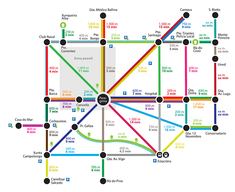
le metrominuto originel, source: https://metrominuto.info/
L’intérêt est de valoriser un autre mode de déplacement que la voiture en affichant le temps réel de parcours à pied entre 2 endroits de la ville, ces derniers étant souvent surestimés.
Cela permet, en additionnant les différentes valeurs temps des segments empruntés d’avoir une idée approximative de son temps de trajet.
Depuis, ce projet a fait des émules. Quand on recherche metrominuto sur internet, la plupart des plans qui ressortent sont espagnols. En France, on peut citer la ville de Toulouse et tout récemment, Saint-Brieuc.
Types


On the 9th of August 2023, I participated in the State of the Map Africa scholarship committee in reviewing the application submitted by members of OSM Africa for sponsorship to this year conference that to be held in Cameroun.