Users' Diaries

Recent diary entries

Posted by valhikes on 15 March 2023 in English. Last updated on 28 March 2023.

I expect this is only a problem in those places that have wild camping allowed as the norm. Bureau of Land Management and Forest Service lands fall into this category and cover a lot of the western United States and a little of the eastern ones. I’ve failed at finding an answer via search engine. There could be something on the wiki for the tourism=camp_site tag, but it’s not there now.

For me, this question has come up specifically in mapping backcountry (hiking) areas where camping is generally allowed wherever a person might want to settle for the night, but there is often a lake where camping has been banned outright. This is more than the usual banning of camping within 100 feet of water that is often found in Congressionally designated Wilderness areas. This is for singled out areas.

Some examples:

Sheep Lake in West Elk Wilderness. (38.7534N, 107.2366WSee rule 6 here.) No camping within ¼ mile.

Gilpin Lake, Gold Creek Lake, and Three Island Lake in Mount Zirkel Wilderness. (40.7825N, 106.6793WSee here.) No camping within ¼ mile.

Shadow Lake in Ansel Adams Wilderness. (37.6946N, 119.1243WSee here.) No camping at the lake or between the trail and creek.

Thousand Island Lake in Ansel Adams Wilderness. (37.7202N, 119.1796WSame link.) No camping within ¼ mile of the outlet.

Lower Golden Trout Lake in John Muir Wilderness. (37.2410N, 118.7207WSame link.) No camping within 500 feet of the lake.

Crystal Lake in Hoover Wilderness. (38.0003N, 119.2454WSame link.) No camping at lake. There’s quite a few more at this link, but this covers all the wildernesses represented.

Geneva Lake (and many more) in Maroon Bells-Snowmass Wilderness. (39.0969N, 107.0775WSee here.) Camping in designated (numbered) sites only. Sites have been marked at Geneva Lake, but not at Capitol Lake, for instance. Included to show a less restrictive case.

See full entry

Location: Gunnison County, Colorado, United States

Üdvözlök mindenkit, immáron 2023-ban, boldog új évet kívánok minden egyes olvasónak, akinek még nem volt esélye, hogy megköszönthessem, e csodás alkalomból. Rögtön az elején egy kis összegzést szeretnék tartani, mi is történt 2022-ben:

  • 2022-ben vettem először részt online OpenStreetMap-es fonón, Matrix-on
  • Megtanultam kezelni a JOSM programot
  • Feltérképeztük egész Siklóst és környékét az épületeket (is) tekintve, figyelve a megfelelő háromdimenziós megjelenésükre is (a szintek és a tetőformák megadásával)
  • Megérkeztek az OpenStreetMap-es matricáim
  • Elértem az országos 9. helyezést az OpenStreetMap aktivitási listán
  • Bekapcsolódtam egy csomó OpenStreetMap-pel kapcsolatos alkalmazás fordítási projektjeibe.

Vidám, új, szép

Ahogyan azt fent is említettem, közeleg az az időszak, amikor beköszönt a tavasz, hosszabbodnak a nappalok, a természet újra “beindul” és a legtöbb térképész, köztük én is, útra kél. A terv nálam a szokásos, a június-július és az augusztus az a hónap, amikor rá tudok igazán kapcsolni a térképezésre, hiszen ekkor van a legtöbb időm, na de jogos a kérdés, mit is várok 2023-tól?

  • Legalább ugyanennyi aktivitást a nyílt forrású OSM-es projektekben mint eddig
  • Felvinni a házszámokat és címeket az épületekhez Siklóson amiket előzöleg felrajzoltunk
  • Feltérképézni (épület szinten legalább) azokat a városokat, falvakat, amiket kigyűjtöttem a jegyzeteimben
  • OSM tapasztalotkról bemutatót tartani
  • Esetlegesen országos OSM-es konferencia
  • Megtervezni, átbeszélni a közúti események jelentésének, megjelenítésének hatékony módját
  • Hirdetni az OpenStreetMap-et a környéken matricák segítségével, és összekovácsolni a helyi közösséget egy klub keretein belül

Búcsúzóul, természetesen csak a következő alkalomig, annyit üzennék, hogy kellemes húsvétot és jó térképezést kívánok minden egyes térképész kollégának!

Posted by watmildon on 14 March 2023 in English.

Act now to save from eye strain!

Did your JOSM UI text become a huge bother to read? Is it too tiny? Are the icons not as you’d expect? You may be suffering from a case of Too High DPI! It’s more common than you think!

Thankfully the medicine is easy enough to apply at home. You’ll need to find and edit the properties of the JOSM.exe file. It’ll be at a path like C:\Users\admin\AppData\Local\JOSM (you’ll need to change “admin” to whatever your user account is). Right click the exe > properties > Change high DPI settings > check “Use this setting to fix scaling problems…”

A screenshot of dialog boxes showing the workflow enable high DPI correction on Windows

Posted by cyton on 14 March 2023 in German (Deutsch). Last updated on 12 May 2023.

Erweiterte Version ist hier: osm.org/user/cyton/diary/401534

Erst die Datenlayer vom geoportal berlin in Qgis anzeigen, dann diese herunterladen als kml. Anlagenbäume und Straßenbäume sind separat im geoportal.

Dann die kml in JOSM öffnen, das dauert erstmal etwas. Die kml Datei dann als .osm Datei speichern.

Die .osm datei mit meinem python script umformen. Dort ändere ich die tags und metadaten, damit sie dem OSM standard entsprechen, bzw. als zu löschen markiert sind.

Diese veränderte .osm Datei wieder in JOSM laden, und source=* und source:date=* hinzufügen, sowie natürlich natural=tree.

Diese Datei dann auf mein Android Handy befördern, und dort in Vespucci öffnen.

Vor ort alle ref und etwa die position der Bäume prüfen.

Dann etwa an den Bäumen fehlende Nummern mit ref:signed=no merken.

Zuhause Dann die ursprüngliche Datei laden und vom Handy die fehlenden ref abschreiben, etwaige positionsunstimmigkeiten oder fehlende Bäume nachtragen, oder gefällte löschen.

Hochladen.

Ich bitte um Verbesserungen für diesen Workflow. Am liebsten hätte ich etwas das StreetComplete näher kommt, Vespucci ist sehr umständlich zu Bedienen. Leider ändern sich oft die sichtbaren Layer, das nervt etwas.

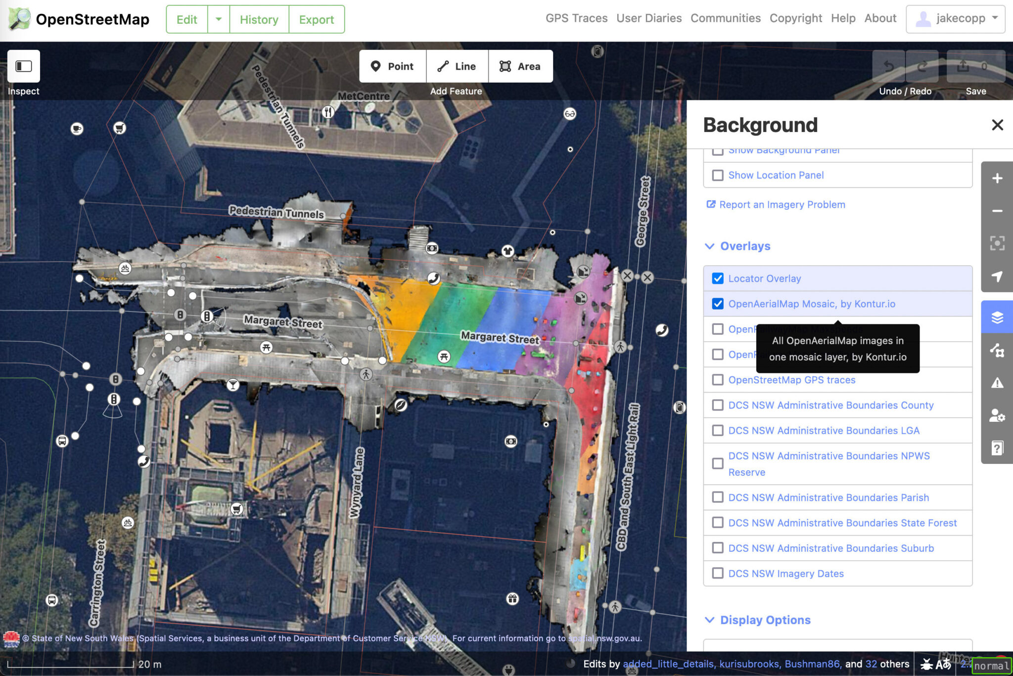
I wrote a blog post on how you can create your own aerial imagery and 3D models of streets with the built in iPhone LiDAR sensor and open source tools in the OpenDroneMap package.

I’ve found you can attach your iPhone to your bike and generate LiDAR point clouds of the kerb and cycleway infrastructure if you go slow!

https://jakecoppinger.com/2023/03/generating-aerial-imagery-with-your-iphones-lidar-sensor/

Let me know what you think! I appreciate any feedback or improvements on the process.

OpenAerialMap imagery in iD editor

Location: Sydney, Sydney CBD, Sydney, New South Wales, 2000, Australia

In Flanders, all traffic signs are open data. This information is hugely useful. Well, it could be. Most of the traffic signs date from several years back and have not been updated since. The Flemish Verkeersborden.vlaanderen project intends to change that. Municipality by municipality, we see updates starting to happen. Several of them have done a complete update, or at least do occasional additions.

In a perfect world, when the municipality decides to change a traffic situation (a new speed limit, a new one-way restriction,…), they start to work in this database. First there’s a planned sign. Then when it is installed, it becomes a real sign. The real sign is offered to the OSM mapping community (and Waze, TomTom, Here, …) and they add the info to the affected street - almost in real time.

We’re not quite there just yet, but the edits in the database that do happen are still useful. Obviously because it makes for a better map. Less obviously because it saves everyone a lot of time. We often get a mail from municipalities: “hey, we have changed reality, can you now change your map”. We want to be able to say: “oh we know, we already updated it!””

So we’re building on a tool in good Road Completion tradition to make sure that if the government provides the data, we can guarantee that we’ll be up to date. This in turn might be a little incentive for more municipalities to keep their bit of the database online. Just like in Road Completion, we “accidentally review” the government data as well. When we map traffic signs, we spot errors. Often user error, sometimes logical errors. These can then help municipalities to improve their data quality or even local reality. OSM data users will be able to see how well we keep track of new traffic signs - they won’t have to trust us on our word that the data is good.

See full entry

The Operations Working Group is looking at what it take to deprecate HTTP Basic Auth and OAuth 1.0a in favour of OAuth 2.0 on the main API in order to improve security and reduce code maintenance.

Some of the libraries that the software powering the API relies on for OAuth 1.0a are unmaintained, there is currently a need to maintain two parallel OAuth interfaces, and HTTP Basic Auth requires bad password management practices. OAuth 2.0 libraries should be available for every major language.

We do not yet have a timeline for this, but do not expect to shut off either this year. Before action is taken, we will send out more notifications. Deprecation may be incremental, e.g., we may shut off creation of new applications as an earlier step.

What can you do to help?

If you are developing new software that interacts with the OSM API, use OAuth 2.0 from the start. Non-editing software can require authentication support, e.g. software that checks if you have an OSM login.

If you maintain existing software, then look into OAuth 2.0 libraries that can replace your OAuth 1.0a ones. We do not recommend implementing support for either protocol version “by hand”, as libraries are readily available and history has shown that implementing your own support is prone to errors.

If you do not develop software that interacts with the OSM API, this change will not directly impact you. You may need to update software you use at some point.

I have been developing Street Spirit, a new style using OpenStreetMap data. It uses Maplibre GL for client side rendering of MVTs generated by Tilekiln, which supports minutely updates using the standard osm2pgsql toolchain.

To focus style development, I have set its aims as being suitable for

  • use as a locator map,
  • to show off what can be done with OpenStreetMap data,
  • to be up-to-date with the latest OpenStreetMap data, and
  • using to orient a viewer to a location they are at.

Although not complete - if a style can ever said to be complete - it is at the point where there’s enough features to give the overall feel of the map, at least for zooms 12 and higher. Lower zooms are missing many features still, particularly roads and rail and some landcover and other fills.

Because the style has a more clearly defined purpose, I’ve been able to use more of the colour pallet than many other styles, particularly compared to styles designed for overlaying other data on top of.

I’ve set up a dev instance on one of my servers, using OSM data from 2023-02-27. Have an explore around.

Some of the bigger areas that need work are

  • Missing mid- and low-zoom features
  • Missing fills
  • A consistent set of POI icons
  • More POIs

If you’re interested in contributing to the work, let me know. Contributing will require some technical knowledge in the following areas

  • MapLibre GL style specification, focusing on layers and expressions, including data-driven expressions;
  • YAML, in particular appropriate indentation for arrays. MapLibre GL styles tend to feature deeply nested arrays; and
  • SQL for writing read-only PostGIS queries if modifying vector tiles.

See full entry

Posted by watmildon on 12 March 2023 in English. Last updated on 12 December 2025.

The header from an incoming email from Google Alerts

Google alerts

In the fall of 2021, there was a notice issued renaming many (~600) natural features in the United States. There was very likely to initiate a cascade of renames for various map features. For example, the name for the road up the mountain peak will likely change to match the new name.

At the tail end of our renaming work, I set up a few Google Alerts related to the theme of the order and promptly forgot about them.

Map updates!

Starting a few months ago the alerts began firing! Each week I would get an email or two about town councils or other agencies planning to rename some feature or another.

Another one came into my inbox this morning announcing that a resort near a renamed waterway was updating it’s name. A bit of checking the resort website to confirm the new name, a few clicks in iD, et voila!

It will certainly be interesting to see whether the roadway, golf course etc get similar updates and I’ve made a note to myself the check back in a few months.

See full entry

Posted by mapmeld on 11 March 2023 in English.

Waymo

I used the driverless ride-share from Waymo to go from the Phoenix airport to downtown. The airport pickup location was a bit out of the way, so I added a taxi stand point on OSM.

Many neighborhoods had building footprints added in Phoenix in just the past 2 years. I was able to add some details to trails or new construction.

Wisconsin and the U.P.

I’m planning a summer bicycle trip from Duluth, east through Wisconsin and Michigan’s Upper Peninsula. There are gravel trails along highways (likely old rail lines) which are commonly used by ATVs and snowmobiles. OSM coverage of these is good. What surprised me on Google Maps is that huge swathes of this area have one low-res StreetView from 2008-09? This might be an entry point for Mapillary and others. I’d like to use this and/or tagging to find bike racks.

Durbin Feeling Language Center

I recently listened to a talk by Chris Skillern (New Leaves: The Cherokee Syllabary in the 21st Century). The Cherokee Nation opened this new language center building in Nov. ‘22, but none of the stories gave its address, and it wasn’t a point on Google Maps. Looking up older news articles from when the building was selected, I found it nearby. Then I saw that the Bing imagery included new construction which was not present on Maxar. Typically I had thought Bing was older? But maybe that’s getting a refresh.

This is part two which highlights the results of the OSM user survey. Read part 1 about demographics and identity and part 2 about the favourite maps

How well-known is MapComplete?

Not that well-known, it seems. In the previous question, 11 people out of 59 who took the time to fill out this question, mistook MapComplete for StreetComplete. This is a clear sign that there is still some work to do.

How did people get to know MapComplete?

How did people get to know MapComplete in the first place?

Via Reddit (13 mentions), Twitter and Mastodon (13 mentions) and the Weekly OSM (9 mentions).

There are honorouble mentions for online chatrooms (6 mentions), word of mouth (6 mentions), the OSM-forum (3 mentions) or ‘arriving via a specific map’ (3 mentions).

From these results, it’s clear that the online spaces where I regularly pitch MapComplete (namely Reddit and Mastodon) also resulted in some people discovering MapComplete.

However, this makes me wonder how applications such as StreetComplete and EveryDoor got to such a big userbase quickly. It seems that creating a mobile phone app with offline capabilities helps with this.

Good questions to ask next year?

I’m planning on doing a similar survey next year (or in one year and a half) to see how things evolve. To be able to compare results, it is interesting to have the same questions, even though some improvements can probably be made (e.g. in wording and more nuanced options).

It is also hard to gauge if people are part of a marginalized group. As such, it is hard to know if we reach those people as well.

But there might be room for other good questions. If you have suggestions, feel free to let them know

Anything else you’d like to say?

This was the question with the most uplifting answers, as many, many people wrote in a compliment about how much they like MapComplete and the work I did! (Well, some of them were probably thinking about StreetComplete)

Thank you everyone involved!

Conclusions

See full entry

Posted by wille on 10 March 2023 in English.

OSMCha is almost eight years old now. A project that I started in my spare time to try to solve some data quality issues of the Brazilian OpenStreetMap community, grew up, became my job for some years, and is now an essential component of the OSM software ecosystem.

Since the beginning, Mapbox has been a crucial partner for OSMCha. They believed in the idea right after I presented it at a State of the Map LatAm conference. In 2015, they had around 10 people doing quality assurance in OSM data and there wasn’t a clear workflow on how to keep track of the changes in OSM. The main idea behind OSMCha was to register all changesets in a database, run some automatic checks to flag possible quality issues, and make the changesets searchable. That solution seemed interesting to the Mapbox team, so they started using it right away, improved the tool, and kept it running during all those years.

However, since June 2021, OSMCha is running without constant maintenance, and only one new feature was added, with the sponsorship of Wikimedia Italia. The lack of a team responsible for monitoring and maintaining the infrastructure caused a few days of downtime.

Now it’s time for a new phase in the OSMCha history! OpenStreetMap US has just accepted it as a charter project. This partnership will provide the structure to raise funds for development and hosting, and will also open the possibility for the entire OSM community to influence the future of OSMCha.

In collaboration with the OSM community, I believe we will be able to keep OSMCha running and provide yet more value for the users.

Soon, we will announce how you can engage in the OSMCha community meetings. Right now you can join the #osmcha channel in the OSM US Slack and continue reporting issues in the GitHub repository.

We also welcome companies and non-profit organizations that are interested in supporting OSMCha. Write to wille AT developmentseed.org if you want to have a chat about how you can collaborate with us.

Posted by نصرقائداحمدالهلالي on 10 March 2023 in Arabic (العربية). Last updated on 21 August 2025.

قرية ضريبة العرش. هي إحدى قرى الجمهورية اليمنية، وتتبع جغرافيا محافظة البيضاء وادريا مديرية العرش منطقة رداع. ويبلغ عدد سكانها 2363 نسمة حسب التعداد السكاني عام 2004، وتقع في الجنوب الغربي لمديرية العرش وتبعد عن مدينة رداع 9كم ومساحتها الجغرافية 21كم مربع. تقع شمال مدينة رداع، وتجاورها قرى [[قرن الأسد ]] و[[ماور]]، مما يمنحها موقعًا متوسطًا بين المعالم الجغرافية والتاريخية للمنطقة.

== المقدمة == بين الجبال الصامتة التي تروي الحكايات، وعلى سفوح الزمن المتجذر، تقف قرية ‘'’ضريبة العرش’’’ شامخةً بهويتها وتراثها في مديرية العرش بمحافظة البيضاء. ليست مجرد تجمع سكني، بل ذاكرة حيّة تختزل أهازيج الماضي وهمسات الجغرافيا. هنا، في وديان خصبة وأعالي الجبال، تنسج ضريبة العرش حكاياتها الخاصة؛ حيث يروي [[جبل مرغم علي]] و[[قلعة حمة جريد]] و[[غيل القطارة]] قصة قريةٍ تتنفس الأصالة، وتزهر بالذاكرة.

== الجغرافيا والطبيعة == تمتاز ضريبة العرش بتضاريس جبلية ووديان زراعية، وتحتضن مجموعة من المعالم البارزة، من بينها: * ‘'’جبل مرغم علي’’’: معلم طبيعي بارز يُعد نقطة مراقبة وموقع حماية لقلعة الملك الحميري شمر يهرعش . * ‘'’غيل القطارة’’’: مورد مائي ارتبط بعادات اجتماعية وموسمية مثل الحصاد والاستبشار الزراعي. * ‘'’قلعة حمة جريد الأثرية’’’: أطلال تاريخية على قمة جبلية، تشير إلى وجود مدينة قديمة عمرها آلاف السنين.

== السكان والأنشطة == يعيش في القرية سكان ينتمون لأسر قَبَلية مترابطة. يعتمد سكانها على الزراعة، وتربية المواشي. تنتشر المجالس الشعبية التي تُستخدم لتبادل الروايات وحل النزاعات.

’'’إلى قلب قرية ضريبة العرش’’’ هو مسار توثيقي داخل القرية، يهدف إلى تسليط الضوء على أبرز معالمها من خلال سرد مرتب يتتبع العلاقة بين الإنسان والمكان. تُمارس في قرية ضريبة مجموعة من العادات والتقاليد الاجتماعية التي تُعبر عن الهوية الثقافية المحلية، من أبرزها:

  • ’'’البراع التراثية’’’: رقصة جماعية تؤدى في الأعراس ومواسم الحصاد، وتتخللها أبيات شعبية تمجد الأرض والانتماء.
  • ’'’مراسم الزواج التقليدي’’’: تبدأ بمسير جماعي من المجلس الشعبي إلى بيت العروس، وتُرافقها الزوامل الشعبية .

See full entry

Location: حمة نخلة, القابل, مديرية العرش, محافظة البيضاء, اليمن