 OpenStreetMap

Identificação das superfícies para produção de energia foto voltaica.
Users' Diaries
Recent diary entries

The 21st to 25th of November was the peak of my OSM journey in 2022. I was selected as one of the SOTMA Scholars to attend the event in Legazpi, Philippines. HOT Asia Pacific HUB was the one who invited me. From Indonesia, Zainab was also selected along with me and the other scholars that came from Nepal, Sri Lanka, Vietnam, Pakistan, India, Bangladesh, and Timor Leste.
This was actually my first time visiting the Philippines. I enjoyed so much stay in Legazpi. We visited the Mayon Volcano, tried various local culinary, and played amazing race games aside from attending many choices of talks and workshops at Bicol University (the venue where SOTMA 2022 was held)

It was wonderful to meet with the OSM community in Asia. We shared a lot of experiences, stories, and meaningful OSM journeys as that one is the one why we were at the event. I always remember every detail of the discussion I have made with almost all of the participants in the SOTMA 2022.
Just after the New Year, there were a few reports of people getting stuck and having to be rescued while hiking in the English Lake District.
There are writeups of this in “The Great Outdoors” magazine here and on Alex Roddie’s blog here. They really are worth reading - the consensus on IRC, Mastodon etc. was that the quality of the article was streets ahead of what you might expect to see in the generalist national press.
Lots has been written about how map and app developers can try and convey information to a user beyond “this is a way of getting from A to B” (including an OSM diary entry that I wrote in December 2022), so I won’t go over that again.
However, one particular quote from the Great Outdoors article did stand out for me, and it’s this:
A spokesperson for Keswick Mountain Rescue Team, which carried out the rescues, said: “There is no path via this route – only a scramble of loose scree which also requires the walker to negotiate the rocky outcrop of Slape Crag. It’s the scene of previous callouts.”
The reason why that stood out is that “path” can mean different things to different people:
-
an actual signed path suggesting that people on foot are encouraged to go via a particular route. In England and Wales there’s the concept of “public footpaths” (and public bridleways), which is a legal right of foot (and horse) access across what might be otherwise private land.
-
some indication on the ground that people often go via a particular route
Often the two coincide, and “where you’re supposed to go” matches “where people do actually go” correspond. Sometimes, however they don’t.
Fifteen days in
Fifteen days into the year and the first UK quarterly project of 2023.
I’m quite encouraged by the early progress we’ve made on notes. As noted in the wiki page, there were just over 30,000 open notes at the start of the year. Right now that figure is 29,327. About 700 new notes have also been opened in that time, so that’s around 1500 notes closed already!
My own mapping efforts comes in peaks and troughs like I suspect many of ours do. Personally I’ve found this project quite fun. An open note can motivate me to help update the map as it gets me looking at the sources available whilst addressing the issue in the note.
So far my preferred way of browsing notes is using ResultMaps by Pascal Neis.
Types of notes
A few types of notes I’ve seen.
Nonsense, or notes used for non-mapping purposes
A fair few notes are clearly non-mappers who dropped a note on the map to share where they were planning to meet up, where they found random stuff or were otherwise planning work. Clusters of notes such as ‘Site Location’ ‘This is the place’ could be found in some cities, or ‘fungi?’ up a hill side.
Stuff that is already mapped
Many notes are highlighting new amenities, houses, roads, etc. These are then found to have been mapped since but the note not closed. An easy win for this project.
Partial info
A note that just says ‘closed’ or ‘paths missing’ is a good cue but would be much easier if it includes the business name that might have closed, or the vector of the missing paths at least - particularly in areas where some paths are already mapped. Or worse, a note that just says ‘Name changed’ with little indication of what was the old name, let alone the new one.
Street Complete generated

مزرعة محمد بن عبدالله الشراري
Posted by Erick Faria on 15 January 2023 in Brazilian Portuguese (Português do Brasil).

Divulgação do OSM
Venho refletindo sobre a pequena capilaridade do OSM no Brasil. Passados alguns anos que estou nessa comunidade, é pouca a adesão dos brasileiros ao projeto. Recentemente eu vim pensando em elaborar conteúdos em meu blog Balaio Científico para divulgar o OSM e como as pessoas podem colaborar com o projeto.
Penso que muitas pessoas não conhecem o OSM e por isso não fazem contribuições. Talvez se fosse mais divulgado, as pessoas teriam mais interesse e a comunidade seria maior, assim como é em alguns países da Europa.
Vou deixar aqui algumas ideias que tenho de conteúdo.
- O que é o OSM e o seu propósito
- Como fazer edições no site do OSM
- Conteúdos sobre o JOSM e como fazer edições.
Sobre o JOSM eu acho que é o mais importante, pois não há muitos conteúdos em língua portuguesa. Há uma carência grande de tutoriais que ensinam como utilizar o JOSM. Se a pessoa não falar inglês, terá muita dificuldade em aprender.
Essas são algumas ideias que deixo aqui registrado para a comunidade. Se alguém quiser colaborar, sinta-se a vontade.
Posted by AngocA on 15 January 2023 in Spanish (Español).
Last updated on 16 January 2023.

El API Overpass y su lenguaje de consultas es algo que los voluntarios de OpenStreetMap debemos aprender en algún momento. Se usa en MapRoulette para definir los desafíos; en JOSM para descargar cierto de tipo de datos; directamente en la consola Overpass-Turbo. En fin, en muchos lugares podemos necesitarlo. Sin embargo, aprender este lenguaje no es tan fácil, ya que la documentación en algunos casos es abrumadora, y la mayoría está en inglés. Pero desde el grupo MaptimeBogota, hemos arreglado un tutorial y lo hemos traducido al español, para que la curva de aprendizaje sea más suave y podamos aprovechar esta excelente herramienta.
Hace 5 años, escribí una entrada en este diario donde listaba algunas páginas para aprender Overpass, de las cuales algunas entradas siguen siendo vigentes:
- Overpass API en el wiki.
- Manual de usuario.
- Overpass turbo en el wiki, que es la página web para ejecutar consultas overpass - QL.
- Overpass-turbo-turorial de datadesk
Otra entrada que había incluido, y que personalmente me parecía la mejor es LearnOverpass. Sin embargo, dicha página dejó de funcionar hace unos años por un llamado interno a Overpass había cambiado por lo que no mostraba resultados. Al parecer, en este momento no hay desarrolladores mejorando o corrigiendo el código. Por tal motivo, decidí hacer un fork y hacerle unas mejoras por nuestro lado (El problema de estas mejoras, es que han habido cambios que no permiten ser integrables con la versión original, ya que la URL base la tuve que cambiar.) La página está en: https://maptimebogota.github.io/learnoverpass/
Las diferencias con la versión original no son solo la correción de la URL hacia Overpass, sino también la corrección de las actividades, ya que un restaurante no existe, por lo que los queries no funcionan. La gran diferencia es que las actividades se tradujeron al español, con eso la comunidad hispanohablante puede aprender más fácilmente overpass.

In 2022, I had the big privilege to join the Humanitarian OpenStreetMap team for the southern and Eastern Africa Hub in Zambia as a volunteer. My experience can not be explained on one plain paper or page. I have received more skills than I expected and overwhelming lessons. In fact, I am not geospatial by profession but a records and archivist manager. I have learned all my spatial life off my profession through the help of #YouthMappers #Crowd2MapTanzania and #HOT. In addition, today I can simply say I am an expert in the Geospatial spectrum and I do train massive of people in this field. I have no paper but the skills and knowledge that i have acquired directing through networking, collaboration, and Mapathons. Lastly, i have done a lot of self-development to ensure that at least I make sure i do something daily in spatial and open mapping areas. Contact info charlesmchilufya@gmail.com +260962256767 (calls and WhatsApp).
Leadership and #Volunteerism
Posted by renminbo on 14 January 2023 in German (Deutsch).
Der “gute Wanderweg” ist ja fast immer ein Pfad, Tracks sind nicht so beliebt und dürfen auch bei Premiumwegen nicht zu oft vorkommen. Und bei Pfaden fehlen mir oft: Ein Tag, dass die Attraktivität einstuft, unabhängig von den schon vorhandenen Tags (s.u.). Da könnten eingehen: schöne Aussicht, Schatten im Sommer, etwas Licht im Winter, interessante Wegführung, Nähe zum rauschenden Bach. Wie man so etwas definieren könnte, ist nachzulesen auf den Seiten der Weg-Zertifizierer (also Wander-Institut etc.).
Wir haben ja eigentlich schon eine ganze Menge an Tags, die die Attraktivität beschreiben können: die Breite, die glatte Wegoberfläche und die Sichtbarkeit (Visibility). Hier scheint mir der Haken zu sein, dass die meisten Renderer diese Tags gar nicht auswerten. Und wozu trägt man Tags ein, wenn sie in den Karten nicht auftauchen? Änderungen am Rendern könnte also helfen.
Trotzdem meine ich, dass es für Apps wie Komoot nicht einfach ist, einen “schönen” Wanderweg per Autorouter zu erzeugen. Und die Zukunft der Wanderkarte liegt ja irgendwo bei diesen Apps.
Ich würde mir ein neues Tag für Premium-Eigenschaften wünschen, das widerspiegelt, ob ein Pfad von einem normalen Wanderer als “Traumpfad” oder als “langweilig und öde” eingestuft wird - also eine Art von Grade 1 - Grade 5.
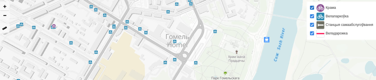
At the end of 2021, I had an idea to collect missing bicycle infrastructure data in Homieĺ (Bielaruś), then visualize and generate statistics. Thus began a project called Bicycle Homiel.
Projects Stages
- Collecting and adding missing data to OpenStreetMap: both missing objects and characteristics of objects
- Export data into a PostgreSQL database
- Calculation of general statistics with SQL, calculation of statistics by districts with PostGIS
- Export geodata into GeoJSON; export statistics into JSON
- Uploading geodata and statistics to the website
Point objects (parking, shop, repair station) were collected using Every Door. Cycleways were photographed, and then missing data were added using JOSM.
And while cycleways were generally fine, most of the shops, parking lots, and repair station were missing in OSM.
Statistics
As of 13.01.2023 OpenStreetMap has 629 bicycle parking, 17 km of cycleways, 14 bicycle shops, and 4 bicycle repair stations in Homieĺ.
Posted by bkil on 13 January 2023 in Hungarian (Magyar).

Részletek / details: https://wiki.osm.org/Hungary/20230116

Hi all ! I want to share the information about that I have created two OpenStreetMap Bot on Twitter
- Open Street Map Retweet Bot
https://twitter.com/OSM_retweet_bot
This Bot is created to follow the recent trends on OSM, What people are thinking or doing in OSM, This bot will try to retweet the tweets with hashtags : #osm, #openstreetmap and #hotosm, Runs every three hour
- Open Street Map Stats Bot
This Bot is an implementation of standalone open source tool called OSMSG https://github.com/kshitijrajsharma/OSMSG, This tool uses osmium to analyze the change files from OSM using different URLs and generates the stats in different file formats such as CSV, JSON, image etc. It has a GitHub action enabled which will run the stats for requested region and global and produces the stats in CSV and image format and shares it with the twitter community, You can follow the GitHub tool itself to see / download the stats. I have added Nepal as monitoring country, but if you want any other countries, you can request it via opening an issue or mentioning bot to twitter. https://github.com/kshitijrajsharma/OSMSG/tree/master/stats Since it uses GitHub, you can also go through the historical stats using GitHub history it will keep updating the same file when it runs and shares the link in twitter
Both projects are open source and beta release, I will be looking for the recommendations and improvements on future ! Thank you !

- Saving lives on water
- Providing data to map dangerous water body areas
- Improving the safety of sails on water bodies
Posted by Chiquinho gavião on 11 January 2023 in Brazilian Portuguese (Português do Brasil).
É minha primeira publicação no diário do OSM, espero poder contribuir com a comunidade e entender melhor as funcionalidades do OSM.
Posted by OMNIBUS on 11 January 2023 in Spanish (Español).

Best regards Johan,
Recently we have opened the project Ciénaga Grande del Bajo Sinú, Córdoba, Colombia.
Despite I have been mapping in this area since 2017, as a colaborator of Water telling stories Social Movement “Movimiento Social el Agua Contando Historias”, I haven´t called other mappers to help us.
We need a lot of support to better mapping such an ecosystem like this. We are planning also write to HOT OSM HUB Latam to propose our project to be accompained by them.
I want to invite all mappers interested to join the task of mapping the swamp.
Here is the link to the wiki, the task and telegram coordination group. If you have any questions I will be attentive, soon we will convene spaces of exchange on this area with the OSM community.
- https://tasks.hotosm.org/projects/13935
- osm.wiki/Colombia/Project-Cienaga-Grande-Bajo-Sinu
- https://t.me/redhumus
Thank you
I was going to do some more field name surveying next week, but shock, horror, it is no longer possible to “make an atlas” on fieldpapers.org.
DeBigC and I have tried to find out why. There was a post on GitHub, even before I noticed it, but no reply. DeBigC was more successful on Reddit, where the reason is given as having run out of funding.
This really is a shame; it was such a useful tool. Maybe there is a way to bring it back?
EDIT 11-01-2023 21:41: It’s back working again, very strange.

Dear all,
Today, v5.7.0 of the OpenStreetMap Carto stylesheet (the default stylesheet on the OSM website) has been released. Once changes are deployed on openstreetmap.org it will take couple of days before all tiles show the new rendering.
Changes include - Unpaved roads are now indicated on the map (#3399)
-
Country label placement improved, particularly for countries in the north (#4616)
-
Added elevation to wilderness huts (#4648)
-
New index for low-zoom performance (#4617)
-
Added a script to switch between script variations for CJK languages (#4707)
-
Ordering fixes for piers (#4703)
-
Numerous CI improvements
Thanks to all the contributors for this release, including wyskoj, tjur0, depth221, SlowMo24, altilunium, and cklein05, all new contributors.
For a full list of commits, see https://github.com/gravitystorm/openstreetmap-carto/compare/v5.6.2…v5.7.0
As always, we welcome any bug reports at https://github.com/gravitystorm/openstreetmap-carto/issues
Posted by Paulo Rogério Albuquerque de Oliveira on 10 January 2023 in Brazilian Portuguese (Português do Brasil).
Eu e Zaila 9 a 11 Jan 23
Posted by Oleg Kholin on 10 January 2023 in Russian (Русский).
Похож на Openstreetmap, но контуры зданий и их положение отличается. Видимо использовали другие космоснимки для прорисовки. Особенно накопать про наполнение карт не удалось. Может кто-то поможет? Чисто ради интереса.