 OpenStreetMap

60% done
Users' Diaries
Recent diary entries
Posted by TreeTracks on 12 January 2022 in English.

Hi folks, for everyone interested in OpenStreetMap’s fantastic road data… I’ve just posted a series of blogs about unsealed roads in Victoria. I’ve pitched it at cyclists rather than mappers to widen the audience, but you should still find lots of interest I hope.
https://little-maps.com/2022/01/12/the-great-vic-gravel-route-exploring-victoria-on-unsealed-roads/
It starts with the question, how far can you ride across Victoria without hitting a paved road? Then displays Victoria’s major ‘gravel zones’, and plots the route that crosses Victoria from west to east which contains the shortest possible distance of paved roads. It’s very circuitous.
A series of supplementary posts expand on the main theme and describe how the maps and routes were made. I hope you find it interesting. Best wishes Ian

Neboder Asfalt Za jebeni Zagreb ovaj kutak ima parkova, jezera, pozitivna 0
Ljetovanje i za guštanje svakog slobodnog trenutka Uživancija
Im new to this but find it very interesting…
Posted by AngocA on 11 January 2022 in Spanish (Español).
Last updated on 23 January 2022.

Este artículo hace parte de una serie de artículos relacionados con notas:
- Las notas de OpenStreetMap.
- Manipulación de notas.
- Análisis de notas.
- Tipos de notas.
- Técnicas de creación y resolución de notas.
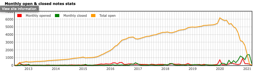
Después de poco más de 1 año de haberme dado cuenta de la gran cantidad de notas abiertas en Colombia, y ver que nadie de la comunidad colombiana estaba resolviéndolas, hoy 10 de enero de 2022, ya puedo decir que ¡hemos cerrado todas las notas viejas de Colombia, habiendo logrado nuestro objetivo! Ahora en adelante, los miembros de la comunidad solo debemos mantener esa baja o nula cantidad de notas abiertas, respondiendo a tiempo a las personas que dan retroalimentación, y hacer las modificaciones respectivas en el mapa.

I often see Nordic pistes on top of already existing way. This is not appreciated. I found a very good tutorial here: https://www.opensnowmap.org/iframes/how-to-eng.html
It adds examples to the “official” docu from here: osm.wiki/Tag:piste:type%3Dnordic
making minor changes to boundary adjustment
To to

C’est passé à 30km/h autour de chez moi depuis début janvier, en particulier visible par le marquage des rues à 50 km/heure (les autres étant par défaut à 30 je suppose, je n’ai pas encore trouvé de source expliquant cela).
Avant de passer à une modification plus vaste et automatique (voir par exemple ici), j’ai modifié ma petite zone de confort en sélectionnant à la main les diverses rues concernées, les rues concernées autour de chez moi sont seulement des residential et des secondary, donc assez simple à filtrer dans JOSM.
Ensuite 1 petit tour sur le rendu cyclosm.
C’est un bon moyen de voir les erreurs, comme par exemple : - j’avais filtré les rues ayant déjà des “maxspeed=*” / or il y avait un maxspeed erroné sur une des rues - j’avais raté la sélection à la main d’une des rues, idem cela saute à l’oeil,
Avant de m’attaquer à l’édition plus large et pour avoir une source supplémentaire concernant les rues à 50, j’ai fait une demande de données à la plateforme OpenData.
À suivre
PS : ceci est mon premier billet de journal, juste pour témoigner de petits moments de contribution :)
Posted by Minh Nguyen on 9 January 2022 in English.
Last updated on 8 March 2026.

A recent id-tagging-schema pull request introduces presets specific to Germany that would make it easier for mappers there to tag schools by type based on locally understood terminology. It’s a great idea, one that hopefully will be extended to other countries like the United States in due time. Some Americans will see a “Kindergarten” preset and intuitively expect a complementary “Elementary School” preset too.
School type presets wouldn’t just be a matter of convenience to mappers. Local maps of the U.S. conventionally distinguish between different types of schools, namely between elementary schools, middle schools, high schools, and colleges and universities. I’d like to eventually see OpenStreetMap-based maps that make the same distinctions.

School classification has long been a tricky subject in OSM. There are at least three documented, machine-readable schemes for classifying schools:

(wird in Kürze geschrieben)
Posted by lubosb on 6 January 2022 in Slovak (Slovenčina).
Last updated on 8 January 2022.
Určené najmä známym jedného zanieteného turistu, ktorý sa príliš nevyzná v podrobnostiach.
Openstreetmap
Ide o mapový projekt, ktorý pokrýva celý svet - tvorený bežnými ľuďmi alebo firmami podľa svojich potrieb alebo záujmov.
Mapové údaje obsahujú informácie o jednotlivých prvkoch. Napríklad prameň pod sedlom Lúčky obsahuje číslo objektu, súradnice a jeho parametre natural=spring, refitted=yes a odkaz na jeho fotografiu. Tie parametre znamenajú, že ide o prameň a bol upravený človekom (strieška, korýtko atď.)
Tieto mapové údaje si môže každý stiahnuť a s dostatočnými znalosťami vykresliť podľa svojich potrieb.
Freemap
Freemap je jednou z možností, ako vykreslovať jednotlivé mapové údaje z Openstreetmap. V našom prípade zamerané najmä pre turistov na Slovensku.
Takže vyššie spomenutý prameň nájdeme aj vo Freemap ale zakreslený nielen krúžkom, ale aj s chvostíkom, ako sme zvyknutý z klasických papierových máp. A doplnený strieškou, čo znamená, že prameň je upravený.
Osmand
Osmand je ďalšou z možností, ako tieto údaje vykreslovať, tentokrát však ako aplikácia pre smartfóny a bez nutnosti hľadať internet v prírode.
Osmand je dostupný cez Google obchod v bezplatnej verzii (skromnému turistovi postačuje) alebo v platenej verzii s neobmedzeným počtom sťahovaní a ďalšími funkciami navyše.
Vhodné je doinštalovať aj doplnok, ktorý doplní aplikáciu o možnosť stiahnutia vrstevníc resp. tieňovania. Ten je však v obchode dostupný asi len v platenej verzii - takže najprv vyskúšajte Osmand, či bude vyhovovať a potom kupujte.
V aplikácii si stiahnite mapu Slovenska (označená názvom Štandardné mapy), v iných krajinách je možnosť stiahnuť aj len vybraný región (Česko > Moravsko-sliezsko, Poľsko > Sliezske vojvodstvo a pod.), keďže stiahnutie kompletných máp Česka a Poľska na občasnú turistiku napríklad v okolí Čierneho pri Čadci môže zabrať zbytočne veľa pamäte.
Posted by SimonPoole on 6 January 2022 in English.
Last updated on 13 January 2022.

As every quarter I’ve updated the contributor statistics in the OSM wiki. The most notable effect is the drop off in new contributors in the 2nd half of 2021, which can at least partly be attributed to the demise of maps.me as a source of new mappers.
This is more obvious when you consider just the new users from this source
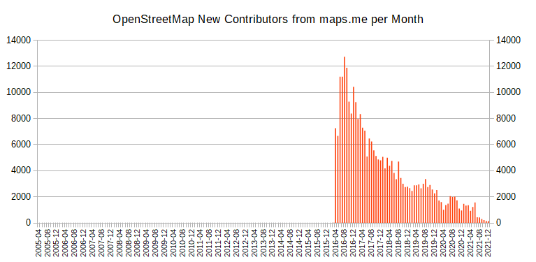
Note that the numbers include new users using organic maps, but even that doesn’t change the trend.
See my diary posts from 2020, 2018 and 2017 for more on the topic.
.png)
I’m really enjoying contributing to OSM so far.
I’m learning JOSM and adding a lot of data in Alexandria VA. Mainly creating row homes and now adding streets, city and zipcode to houses.
I add house numbers via Street Complete.
I also started a next door group. Hopefully others join! There’s a lot to do.
Posted by Mateusz Konieczny on 6 January 2022 in English.

osm.wiki/Editor_usage_stats has some interesting parts for 2021
- iD use continues to increase by percent (both edited objects and distinct users)
- iD by number of distinct users dropped from all-time-height in 2021
- end of lockdowns? OSM slowing down? 2018 to 2019 also dropped, this year JOSM edit volume went from 996 million to 905 million edits
- JOSM still used for over 50% of all contributed edits by objects
- StreetComplete is the second most popular editor (by number of distinct users), usage almost doubled
- StreetComplete is still almost not noticeable by edited object volume - 0.8%
- but last year it was 0.3%, it tripled to 12 million edits
- failed import and its revert is the second most popular editor, by count of edited objects
- 1.5% of all edits in 2021
- https://forum.openstreetmap.org/viewtopic.php?pid=760818#p760818 is an example of what was imported
- new editors: Organic Maps
- ok, “new” as it is MAPS.ME fork
- and that failed Finland forest import
- MAPS.ME continues to die, also as an OSM editor
Removing private trail from map I am attempting to update the map to remove an area listed as a trail that is not a trail and on private property. My hope is that no one will use that non-trail. I made the changes but not sure how to save them to the actual map..
Posted by Cristoffs on 5 January 2022 in Polish (Polski).

Dzięki pracy naszych kolegów Tomasza Tarasia oraz Maćka Bandurskiego pod adresem https://aed.openstreetmap.org.pl uruchomiliśmy stronę, która wyświetla wszystkie lokalizacje AED na terenie Polski znajdujące się w zasobach OpenStreetMap. Dane te są również dostępne bezpośrednio do pobrania w pliku CSV pod adresem: https://aed.openstreetmap.org.pl/aed_poland.csv oraz jako geojeson: https://aed.openstreetmap.org.pl/aed_poland.geojson
Wszystkie osoby posiadające konto w systemie OpenStreetMap mogą na stronie dodać do mapy takie urządzenie, korzystając ze specjalnego formularza oraz uzupełnić dane już wprowadzonych bez konieczności używania dodatkowych edytorów.
Zachęcam wszystkich edytorów, by w swojej okolicy sprawdzili czy takie urządzenia są dostępne i czy są już wprowadzone do OpenStreetMap. Informacja o ich lokalizacji może uratować czyjeś życie. Wszystkich, którzy chcieliby nam pomóc w tym projekcie zapraszam do kontaktu mailowego na adres: wlodzimierz.bartczak@openstreetmap.pl
Dokładny schemat mapowania urządzeń można znaleźć na wiki
Hi
Posted by amapanda ᚛ᚐᚋᚐᚅᚇᚐ᚜ 🏳️⚧️ on 5 January 2022 in English.
Last updated on 6 January 2022.
