 OpenStreetMap

I am a danish guy, age 71 and living i Clemenules 17/1 0891 Orihuela Costa. Me and my wife, slso danish, are in our house 3-6 month pr. year. My time are going with a lot of biking, MTB and race.
Users' Diaries
Recent diary entries

HOT members - welcome to the 2021 election cycle! If you’ve been considering running for a board seat, or simply my informal take on things, read on!
This year, we have several unique factors at play:
- HOT has just entered (as of July) its second year of implementation of Audacious Project implementation, working toward a goal of engaging 1 million contributors to map an area home to 1 billion people across 94 countries.
- The organization has gone through a period of rapid change in the past 12 months, opening two regional hubs, adding roughly 45 staff members, doubling our annual budget, and putting the organizational foundations in place to dramatically scale up community support. We’ll continue to scale from 2021-22.
- The environment around us has also changed dramatically, opening up new possibilities with recent technical advances and forcing us to re-think ways of working under Covid-related movement restrictions.
- Lots more has been happening: see our Annual Report (I’ll write more on where we stand and where we’re heading next month).
- Amidst all of this, five of seven board seats are up for grabs.
I’ve been reflecting on this. As someone who works to serve and expand the open mapping / OpenStreetMap movement every day, what would position HOT in the best way to support the movement? Given the changes and uncertainty, what specific skills would add the most value? What specifically do we need coming out of this year’s Board of Directors election cycle?
I’ve come up with a rough grouping of skills and experiences that have the potential to add significant value as part of HOT’s Board of Directors. HOT has an incredible diversity of lived experiences in our membership, though, so if you don’t see your particular experience here, it doesn’t mean it wouldn’t benefit HOT.
In no particular order, here’s my top five archetypes:
The serial entrepreneur or tech trend-setter
Posted by Sadless74 on 10 September 2021 in Russian (Русский).

🗺 Конкурс картографирования OpenStreetMap в 163 российских городах с >100К жителей.
Сайт конкурса http://osm-competition.tilda.ws/
Инструкция для участников конкурса
Проходит с 10 по 30 сентября 2021 года
Призы победителям:
* Денежное вознаграждение. Первые три победителя получат по десять, пять и три тысячи рублей
* Книги и наклейки
* Один из участников получит книгу от «Городских проектов», а другим достанется урбанистическая литература и стикер-паки
*Приз и открытки за участие от спонсоров. Спонсоры вручат специальный подарок, а каждый участник, выполнивший минимальный объем задач, получит памятную открытку
Необходимые атрибуты
1. Число полос
2. Скоростной режим (включая указание скорости по умолчанию)
3. Пешеходные переходы (регулируемые/неругулируемые)
4. Островки
5. Искусственные неровности («лежачие полицейские»)
7. Освещение
6. Остановки ОТ
8. Барьерные ограждения
9. Маршруты транспорта
Обсудить в телеграмм группе участников или на форуме ОСМ https://forum.openstreetmap.org/viewtopic.php?id=73796

MY company has just released quickosm 2.0 a simple qgis plugin that will let you query overpass and import osm data into your qgis projets.
Posted by SmartFinn on 9 September 2021 in Russian (Русский).
Last updated on 20 September 2021.

Проблема
Прогуливаясь по Угледару, с запущенным приложением StreetComplete, заметил что маркер местоположения находится не на дороге, по которой иду, а паралельно, на полигоне здания, выше. Тогда я грешил на точность GPS в условиях городской застройки, что конечно тоже верно, но проблема оказалась глубже.
Почти все объекты в Угледаре нарисованы поверх аэроснимков Bing без их смещения к GPS координатам. Погрешность небольшая, 3.6-4.3 метра, но в купе с погрешностью телефона/навигатора в 3.2-4.8 м получаем в лучшем случае 6.8 м. Учитывая плотность застройки города (ширина подъездных дорог, которых большинство, 4.2 м) — ситуация плачевная.
Подготовка
Среди загруженных GPX треков мало тех которые непосредственно проходят через город, да и на их точность рассчитывать не приходится. Потому я решил сделать свои, для чего требуется:
- Объект(ы), которые отдалены от высоких зданий и границы которых отчетливо видно на спутниковых снимках
- Телефон, в качестве GPS трекера
В качестве объектов выбрал старую танцплощадку на северо-востоке Угледара, и спортивные поля школы №3 на северо-западе. Как GPS-трекер выступил OsmAnd, в настройках которого указано писать точки как можно чаще и не писать те, у которых точность менее 5 метров.
Сев на велосипед покатил к первой точке. Танцплощадка представляет собой круг, по которому я медленно прошел, но к сожалению на GPX треке круга не получилось. Тем не менее, подогнав подложку под имеющее получил удовлетворительный результат, но сразу редактировать весь город не рискнул.
Дождавшись удобного случая поехал к спортивным площадкам. Вход на них оказался под замком. Сориентировавшись на местности решил пройтись с трекером по почти квадратной площади перед школой.
С этими данными, которые к тому же подтвердили предыдущее, получил следующие сдвиги (Imagery Offset):
-
-0.09,5.32Bing aerial imagery -
-2.73,5.83Mapbox Satellite -
-2.1,5.39Maxar Premium Imagery -
-2.13,5.38Maxar Standart Imagery
این سه راه با هم فرق دارند. برخی کاربران برای هر راه پیادهای گزینهٔ پیادهرو را انتخاب میکنند اما این گزینه دقیقاً اشاره به پیادهرو خیابان دارد و استفاده از پیادهرو مثلاً برای راههای داخل پارک اشتباه است. مثل اینجا:

بیشتر دیدهام ویرایشهایی که با iD انجام میشود این مسئله را دارند. بعد از اینکه راهی را در محیط ویرایشگر انتخاب میکنیم و سپس در قسمت «جستجوی عارضهها» واژهٔ «پیاده» را جستجو میکنیم این سه گزینه به ما پیشنهاد میشود:
- «راه پیاده» که معادل highway=footway است؛
- «پیادهرو» که معادل ترکیب highway=footway و footway=sidewalk است؛
- «پیادهراه» که معادل highway=pedestrian است.
به نظرم رسید ترجمهٔ «پیادهرو» را به «پیادهرو خیابان» تغییر بدهم. امیدوارم این تغییر در آینده به انتخاب برچسب صحیحتر کمک کند!

I was intrigued by the photo on the wiki illustrating the hardest level of the Swiss Alpine Club scale for mountain hiking (known as SAC Scale on OSM and tagged with sac_scale). I couldn’t identify the location and wondered by looking for ways with the tag I could do better.
A quick overpass query revealed widespread misuse of the sac_scale tag for true alpine climbing routes which the Swiss Alpine Club grades using a completely different scale.
A few of the more egregious examples:
- Geant-Rochfort Arete. A classic high-level snow ridge encompassing a couple of 4000ers. Tagged with highway=path and sac_scale:

Description of route on Hikr.
- Biancograt of Piz Bernina: apparently trail visibility is horrible, which is a bit of a surprise, because the ridge is rather narrow.
Posted by tajvano on 8 September 2021 in Chinese (Taiwan) (中文(台灣)).
Last updated on 22 December 2021.
已完成道路
東西向
- 太平街
- 忠孝路
- 仁愛街
- 中山路
- 和平街
- 光明路
- 正新南路
- 公園路
南北向
- 健康路
- 竹林路
- 和平街
- 民族街
- 中正路
- 護安街-和平街31巷
- 建國街
已完成橋樑:650林子內橋
Test

Walking around and adding new objects to OSM helps to get to know the area a lot.
At the moment, I’m adding only street names and house numbers. Adding roads or deleting some, because my area is relatively new and things change here fast.

临港大发展 洪庙大振兴
Posted by amapanda ᚛ᚐᚋᚐᚅᚇᚐ᚜ 🏳️⚧️ on 6 September 2021 in English.
Last updated on 7 September 2021.

What I did in OpenStreetMap in August 2021
%20by%20Vince%20Emond.jpg)
tldr; hot_tech is running the second round of an ai-assisted mapping study
Call to action: please sign up to participate or share with your networks
time: read: 5m | sign-up: 5m
best before: Sept 17th, 2021
Hi all!
As some of you may remember, earlier this year HOT undertook an experiment to compare tradiational mapping with AI-Assisted mapping. After the first round of results have been gathered (soon to be released), hot_tech will be undertaking round two (Sept 17th, 2021) and we are looking for beginner mappers (<50 changesets) to join the study.
The experiment is designed to compare the results of traditional remote mapping workflows (editing in ID Editor) with emerging AI assisted workflows (editing with RapID). To do this, we will be conducting mapping experiments of two locations (Uganda and US), with beginner mappers (<50 changesets) using the two different remote mapping workflows (RapID and ID).
On Sept 17th, 2021, we will run one mapathon of 90 minutes, with participants being randomly assigned - prior to beginning mapping - to map building footprints with either ID or RapID. Data will be gathered on the existence of map features in two locations (US and Uganda) from which we will compare the completeness of mapped features and similarity of map features when compared with an OSM reference dataset.
For the mapathons we will be using convenience sampling from our networks by generating a public call for participants.
A couple of specific asks, please email if:
_ You would like to be involved in any capacity (organising, recruiting, sharing, supporting, please shoot me an email)
_ You would like to support the mapathons specifically, that would be great
_ You would like to participate in the mapathons please please sign up to participate HERE »
Thanks all, I hope everyone is safe and well and looking forward to exploring this with you all soon.
Kindness,
bo

Street I live on.
Posted by SimonPoole on 5 September 2021 in English.
Last updated on 17 December 2021.

As a rule of thumb, the primary name would be the most obvious name of the feature, the one that end users expect data consumers to expose in a label or other interface element.
From the OSM wiki Key:name
I’m currently tidying up a couple of loose ends in preparation for the release of version 16 of Vespucci. One of those dangling bits was supporting the new format of the name-suggestion-index (NSI).
The NSI was conceived back in 2013 by Aaron Lidman as a list of canonical name spellings for chains of stores, restaurants and other similar facilities, most notably for use in iD. Vespucci has supported use of the NSI nearly since day one, see a diary post from 2014 (this works quite differently in current Vespucci versions). Since then it has morphed to a, supposedly, authoritative source of tagging for a very wide range of objects. Some would say that the current version has expanded its reach far beyond what is actually useful (flagpoles ffs), but that is not the topic of this post.
Prior to the release of iD 2.20 the NSI had been in a long period of stasis with updates being made to the data, but these were not actually being deployed and given the larger format changes I had all but forgotten about it and the data in Vespucci was really old. However over the last couple of months some colleagues pointed out some weird behavior in Vespucci and iD when using NSI generated presets for tagging. In particular name tags are being added to things like excrement bag dispensers and automated postal package depots.
Posted by Gustavo22Soares on 4 September 2021 in Portuguese (Português).

Como já falando no texto anterior o OpenStreetMap não é tão amigável com o usuário comum mas serve muito bem para os cartógrafos, também recebi muitos comentários que o OSM não é um produto final e sim uma base de conhecimento compartilhada e até algumas comparações com linux… Mas usar o OSM não deveria ser difícil ou depender do rebrand de grandes empresas, acredito que tem como atingir o usuário comum e ganhar mercado e sendo opensource e ainda trazer mais mapeadores para a comunidade.
A alguns venho trabalhando no que seria um cliente ideal em que eu realmente usasse e recomendaria para meus amigos e colegas isso venho crescendo desde que eu li o artigo The Mobile Map App Part I: The Void então descidir criar um rascunho:
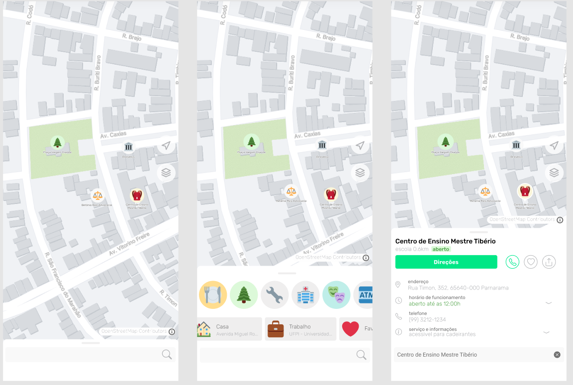
Só que para tirar essa ideia do papel eu preciso de sua ajuda, caso você tenha alguma experiencia em Flutter ou React e queria levar o OpenStreetMap a um novo patamar por favor entre em contato: gustavo22soares@pesso.al
As already mentioned in the previous text OpenStreetMap is not so friendly to the common user but serves very well for cartographers, I also received many comments that OSM is not a final product but a shared knowledge base and even some comparisons with linux… But using OSM should not be difficult or depend on the rebrand from big companies, I believe that it has a way to reach the common user and win market and being opensource and still bring more mappers to the community.
For some time now I have been working on what would be an ideal client that I would really use and recommend to my friends and colleagues. This has been growing since I read the article The Mobile Map App Part I: The Void so I decided to create a draft:
But to get this idea off the paper I need your help, if you have some experience with Flutter or React and want to take OpenStreetMap to a new level please contact me: gustavo22soares@pesso.al

I’ve noticed that Anchorage has several bus routes, yet only one has actually been somewhat put on the map (route 102). I’ve looked into what setting up a bus route would look like and after setting up another one halfway (route 10), I’ve figured out what needs to be done in order to complete a large project like this.
First off, Openstreetmap is not very good with creating a bus line easily, as tagging needs to be in a specific order according to the Wiki page on bus routes (the issue is currently being looked at as of now), so I think the method of mapping bus routes will be most efficient when done this way:
- Each bus platform/stop must be mapped and placed into a relation before any route is mapped with ways. If the ways are set up first it can be quite a pain to move the bus stops to the top afterwards. I made this mistake when setting up bus route 10 and it was not fun.
- After that is done, the bus routes can finally be placed down. It doesn’t matter as much if every stop in Anchorage has been mapped so long as all the bus stops on that specific line is mapped out.
This is a pretty large project that’s going to take a bit of effort, so any outside help is greatly appreciated. Also, if you’re knowledgeable in creating bus routes and you see any errors in this method or my mapping, please feel free to correct me or the issue.

OpenStreetMap must not be the petri dish of political-driven nonsense
Yet here we are again, the Chinese Commies just spit on everything they thought was rightful. Yes yes, I explicitly use the term 'Commies' as gallantry since I came from 'the Taipei and environs' by their courtesies. BTW, 'Taiwan' or 'Formosa' is the place if you can't recall.
I was rather indolent to express any political views on the OpenStreetMap as it should be a site to record facts, not a place to be poisoned by political flim-flam. However, the landscape has changed too much from a niche and friendly environment to a colossal and somewhat hostile one.
OpenStreetMap is not and shalln't be the sacrifice in the political struggles
More and more Chinese mappers joined as China rises, but many rather acting irrationally and nonconstructive. These mappers can mainly be categorised into 4 major doctrines:
- OSM datasets exploiting: denying the existence of Xinjiang internment camps, the de facto status of Taiwan, Penghu, Kinmen and Matsu, nor the territorial dispute on the South China Sea and Pinnacle Islands;
- Invalid notes abusing: creating notes unrelated to data qualities and asserting Chiese political view;
- OSM wiki vandalising: improper editing on the page ‘Taiwan’ and clearing OSMTW community early discussions;
- Heavily mapping on unrealistic constructions in a foreseeing future: e.g. Beijing-Taipei Expressway, China National Highway 319 (Kaohsiung-Chengdu)
Unfortunately, all of them were never cared to listen nor discuss, while the community members try to be friendly and sagacious. Which let me rethink the need to embrace or cope with such gibberish, rather.
Posted by ignaciolep on 2 September 2021 in Spanish (Español).
Last updated on 13 August 2023.

Resumen: “Mapear” y “cartografiar” significan lo mismo, pero la primera es más corta y comunica el concepto de “hacer mapas” de manera más sencilla y directa. Además, “mapear” es un término aceptado por la RAE y usado en todo el mundo hispanohablante, por lo que no hay razón para evitarlo o reemplazarlo.
¿Qué verbo usas cuando quieres expresar la acción de hacer mapas? ¿Mapear o cartografiar? Esta pregunta puede parecer trivial, pero tiene su importancia en el ámbito de la traducción y la edición de mapas, especialmente en proyectos colaborativos como OpenStreetMap.
Como colaborador de traducciones “crowdsourced”, de vez en cuando me encuentro con algún traductor que reemplaza la palabra “mapear” por “cartografiar”. Esto lo hacen porque creen que “mapear” es un chilenismo o una “traducción de baja calidad” por parecerse a su versión en inglés (“to map”). Pero, ¿es realmente así?
En primer lugar, hay que aclarar que “mapear” no es un anglicismo, sino una palabra formada a partir del sustantivo “mapa” y el sufijo “-ear”, que indica acción. Esta forma de derivación es muy común en español. Por tanto, no hay nada de malo en usar “mapear” como verbo.
En segundo lugar, hay que señalar que “mapear” no es un chilenismo, sino una palabra reconocida por la Real Academia Española (RAE) y usada en todo el mundo hispanohablante. Según el Diccionario de la lengua española (DLE), “mapear” significa “hacer mapas”. Esta definición se ajusta perfectamente al ámbito de la cartografía, que según el mismo diccionario es el “arte de trazar mapas geográficos”.
Es cierto que el verbo “mapear” se incorporó al DLE en 2014, con la publicación de la 23.ª edición, y que se trató de un aporte de la Academia Chilena de la Lengua, por lo que quedó etiquetado como si fuera un término dialectal. Sin embargo, eso no significa que solo se usara en Chile ni que fuera una novedad. De hecho, hay ejemplos de uso de “mapear” en textos anteriores a 2014 y procedentes de diversos países.