 OpenStreetMap

uploaded a public path through Great Hollanden to avoid walking on Riding Lane on way to Hildenborough station.
Users' Diaries
Recent diary entries
Ст. Микуличин
Posted by pedro_tharg on 31 July 2021 in Brazilian Portuguese (Português do Brasil).

Algumas razões e motivos para a realização do mapeamento de produtos e contaminantes químicos dispersos em um ambiente
Posted by SomeoneElse on 30 July 2021 in English.
Last updated on 15 October 2021.
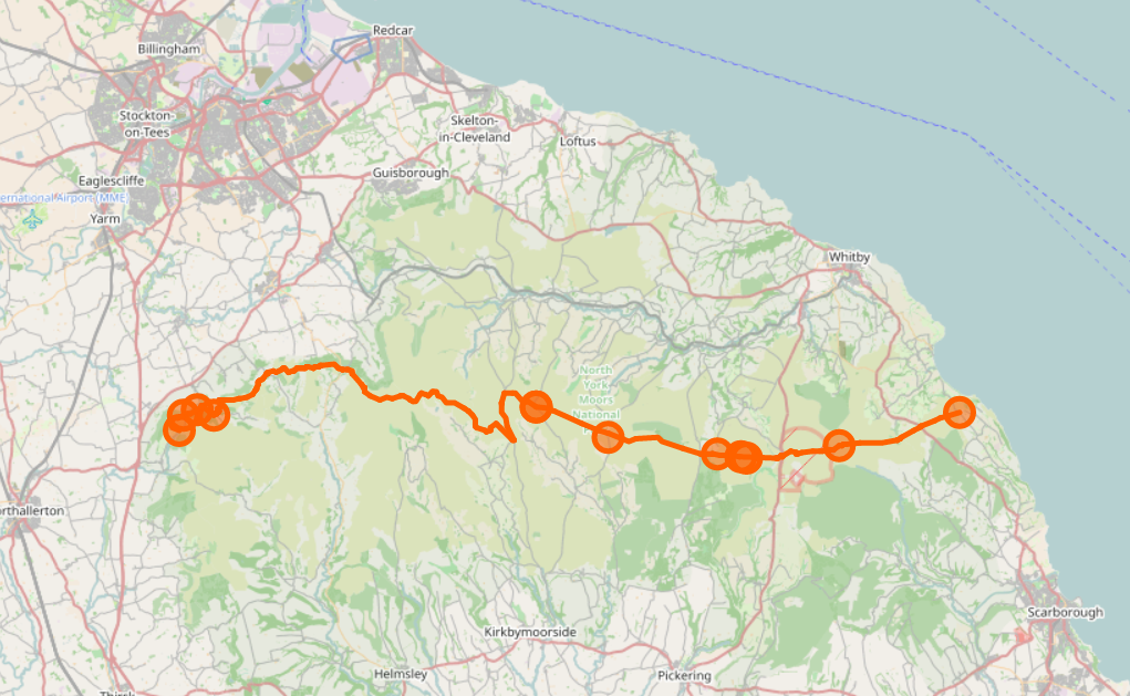
Previously I wrote about checking National Parks in Britain and Ireland for breakage, by counting the number of valid polygons in a rendering database.
A similar approach can also be used to check line features as well as polygons. It’s possible to count the number of contiguous sections of a given polygon. For example, here’s the Lyke Wake Walk, which is in one piece:
psql -d gis -c "SELECT count(*) FROM planet_osm_line WHERE (osm_id = '-1996318');"
 count
-------
     2
(1 row)
and here is the Sabrina Way, which isn’t:
psql -d gis -c "SELECT count(*) FROM planet_osm_line WHERE (osm_id = '-537430');"
 count
-------
    12
(1 row)
If something is changed in OSM that introduces an extra piece, or fixes a gap, that number will change. This script can be used to count the change in the number, like this:
Change in relation components for Sabrina_Way 537430
3c3
<     12
---
>     13

The City of Fremantle has new speed limits, mostly 40km/h. I’ve been trying to get the map up to date. They provide a bit of a map (archive), and I’m checking against the new signs as they go up. I don’t know why they don’t care about what happens west or north of the railway line.
I normally don’t really care about vehicle speed limits, because I don’t drive, but this was an interesting exercise in JOSM filters and non-geometric mapping.

Another short post on street furniture (you can definitely tell I haven’t got out much in the pandemic as this is the sort of mundane detail I’m focused on at present). Once again these are, as much as anything, notes for myself.
The Ranty Highwayman wrote a great detailed post about the different types of tactile paving and how they should be used in the UK: https://therantyhighwayman.blogspot.com/2015/02/tricky-tactiles.html. It’s very helpful if confused about the various types, and may help to spot incorrect layouts (which can be tagged).
My only additional contribution is to note that in the UK the tactile paving slabs tend to come in a very restricted set of sizes:
- 40 cm square. The most usual size for both blister & corduroy (hazard warning) paving. There are 6 blisters up & across. I haven’t counted the lines.
- 45 cm square. A bit less frequent, 7 blisters across (illustrated in the blog post above).
- larger (perhaps 60cm+). Blister interval possibly bigger than in the previous two examples, 9 blisters a side. I haven’t measure these slabs precisely, but this is an example on Mapillary.
More examples of tactile paving can be found on suppliers’ sites such as this one.
So far, so unbelievably nerdish, but there’s a nifty bit of knowledge from this info which can be applied to mapping much more widely! Knowing the paving slab sizes makes it easy to estimate the width of pedestrian crossings, crossings at dropped kerbs and any pavement/sidewalk where the corduroy hazard slabs are used. This can not only provide a simple way to survey widths without using a tape measure or laser device, but can also assist in estimating widths based on experience.

This blog post is a version of my recent SOTM 2021 presentation on the OpenStreetMap Standard Layer and who’s using it.
With the switch to a commercial CDN, we’ve improved our logging significantly and now have the tools to log and analyze logs. We log information on both the incoming request and our response to it.
We log
- user-agent, the program requesting the map tile;
- referrer, the website containing a map;
- some additional headers;
- country and region;
- network information;
- HTTP protocol and TLS version;
- response type;
- duration;
- size;
- cache hit status;
- datacenter;
- and backend rendering server
We log enough information to see what sites and programs are using the map, and additional debugging information. Our logs can easily be analyzed with a hosted Presto system, which allows querying large amounts of data in logfiles.
I couldn’t do this talk without the ability to easily query this data and dive into the logs. So, let’s take a look at what the logs tell us for two weeks in May.
Bei einer kleinen Radtour entlang der Autobahn-Baustellen bin ich auf ein paar ‘interessante’ Schilder der Autobahnmeisterei gestoßen.

Die Lotsenpunkte sollen den Baustellenfahrzeugen (und eventuell später auch Einsatzkräften?!) helfen, einfacher an den Zielort zu kommen. Als hätte Andi nicht schon genug Geld verschwendet, scheint jetzt auch noch Geld in W3W zu fließen :-(
Over time I’ve noticed features appearing on highways & paths which are unusual and which I don’t know how to describe. Often these become much more prevalent. Recently I made an effort to do some reasearch on a couple of these and learnt some useful terminology (documented here so I don’t forget):
- Deterrent Paving: These is a form of paving which it is difficult to walk or drive over. It is used in a range of situations, but a common use is where a road has been blocked for cars and cycles are allowed through but there has to be some provision for access by emergency services (often labelled “FIRE PATH” in the UK).
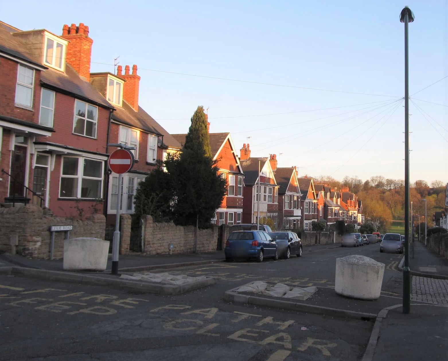
There is quite a wide range of different types, some aimed more at stopping pedestrians. The presence of deterrent paving may represent a significant hazard for people with reduced mobility or impaired sight.
Posted by AngocA on 28 July 2021 in Spanish (Español).
Last updated on 22 January 2022.

Este artículo hace parte de una serie de artículos relacionados con notas:
- Las notas de OpenStreetMap.
- Análisis de notas.
- Tipos de notas.
- Técnicas de creación y resolución de notas.
- Finalización proyecto de cerrado de notas en Colombia.
En el artículo anterior, traté diferentes aspectos de las notas, una funcionalidad core de OpenStreetMap. Hoy voy a plasmar esos conceptos con ejemplos gráficos, principalmente reflejando el flujo de las notas, desde su creación hasta su resolución.
Como expliqué en el artículo anterior, el flujo de las notas es el siguiente:
- Creación.
- Visualización.
- Adición de comentarios – opcional.
- Resolución.
- Reapertura – opcional.
Creación
La creación de las notas se puede hacer desde diferentes aplicaciones. Algunas ofrecen facilidades para escribirlas, y otras tienen algún texto plantilla para solo llenar unos campos.
Antes de crear cualquier nota, lo primero a tener en cuenta es haber identificado algo en terreno que no corresponde a lo que está en el mapa. Esto puede ser:
- La ausencia de algo en el mapa, que existe en realidad. Por ejemplo, falta un comercio de tal tipo, con tal nombre.
- Algún dato que no corresponde entre el mapa y la realidad. Por ejemplo, no es un comercio, sino una oficina.
- La existencia de algo en el mapa que realmente no existe. Por ejemplo, un comercio que ya cerró.
Desde la página de OSM
Una vez hemos identificado lo que queremos reportar en el mapa, vamos y lo buscamos en la página de OpenStreetMap.org haciendo zoom, moviendo el mapa según corresponda.
Well, I just wanted to see what this feature does so I’m posting some useless stuff.
As listed on my profile page I muck with mkgmap and my Garmin Nüvi for the USA. These Nüvis can only handle 4GiB map files. So I look at the diagnostic output of mkgmap and noticed we’ve got a billion live nodes that need to be parsed for just the USA. Not exactly sure when it passed this mark, but it was fairly recent.
1 billion USA nodes, and each node has a longitude and latitude that if were represented by a floating point number (single precision float - 32 bits) would mean 4 bytes per longitude, 4 bytes for latitude. Then an identifier…
This would 8GB by itself, without ways to link the nodes. Impressive that osm.pbf can “compress” all these nodes, ways, relations, and all the tags into a (currently) 8GB file.
But anyway been trying to go through a bunch of the QA issues in the map data. I think I got through one pass of the roundabout routing issues that are shown in mkgmap. I was playing with OSRM and GraphHopper with the errors and with the fixes, I’m surprised that people haven’t found some roundabouts that OSRM/GraphHopper completely refuse to enter… they’re scared of roundabouts! Hopefully OSRM, GraphHopper, and even my Garmin Nüvi will now route through them properly.
Alright that’s enough for now here. If this text is even useful…

I am driven by an intrinsic desire to make the world a better place. Together we can do that by mapping using OpenStreetMap!
Minor mapping on some forests in Ecuador
Posted by DidierOllivier on 26 July 2021 in French (Français).
Certaines communes des départements de la Charente, de la Charente-Maritime, des Deux-Sèvres, de la Vienne ont comme région la Bourgogne-Franche-Comté au lieu de la Nouvelle-Aquitaine Ci-dessous le message de réponse de Heredis puis celui de ma demande ———- Sandra de Heredis (Heredis) 26 juil. 2021 à 16:05 UTC+2 Bonjour, Merci de nous avoir contactés ! Les données internet affichées dans le Monde à la Loupe proviennent de OpenStreetMap. C’est un projet collaboratif, ce qui signifie que vous aussi, vous pouvez y participer. Voici un article très complets pour vous aider à utiliser pleinement cette fonction : Contribuer à OpenStreetMap : https://help.heredis.com/contribuer-a-openstreetmap/ Plus sur help.heredis.com Merci et à bientôt ! L’équipe Heredis vous souhaite un bel été Cordialement, Sandra de Heredis Chargée de clientèle www.heredis.com ———- Didier 25 juil. 2021 à 19:58 UTC+2 Madame, Monsieur, Je vous informe que je viens de constater aujourd’hui même que bon nombre de communes (mais pas toutes) que j’utilise dans ma généalogie concernant le département de la Charente-Maritime, région de la Nouvelle-Aquitaine sont reconnues par vos soins comme faisant partie de la région Bourgogne-Franche-Comté. Cette erreur très gênante pour l’établissement ou la lecture de certains documents nécessite une régularisation assez rapide pour le crédit de votre logiciel. Je vous remercie par avance de l’intérêt que vous voudrez bien porter à ma demande et me tenir informé de la suite que vous comptez y donner. Veuillez agréer, Madame, Monsieur, mes sincères salutations. Didier OLLIVIER
Posted by raspbeguy on 26 July 2021 in French (Français).

Mon prochain chantier sur OpenStreetMap va être de cartographier le diocèse de Grenoble-Vienne avec toutes les paroisses qui le composent. J’ai déjà ajouté le diocèse, la prochaine étape sera de mettre la paroisse locale, puis toutes les autres, et trouver un moyen de les organiser en doyennés.
I am saving this list here as a to-do-list. Should anyone suggest a proper way to map this stuff, I will try to enter it in OSM. These are places where the owner can fine you with some hundreds euro if you drive through, if you stay more than 15 minutes at the gas station, if don’t spend enough money at the gas station, and so on.
Diese ist eine List von bekannte Besitzstörungsfälle in Wien:
- Shell-Tankstelle, Ecke Katsushikastraße/Leopoldauer Straße 49, 1210 Wien (hinter der Brücke bei McDonalds)
- Sackgasse Breitenleer Straße 50, 1220 Wien
- Liegenschaft Siemensstraße 105A, ident mit Richard-Neutra-Gasse 3, 1210 Wien
- Donaufelder Straße 135, 1210 Wien (zwischen Hofer und Einkaufszeile Schichtweg)
- Franz-Eduard-Matras-Gasse 5-7, 1220 Wien Es handelt sich hier um eine Sackgasse an deren Ende es kein Weiterkommen für mehrspurigen Verkehr gibt. Das Wenden des Fahrzeuges ist nahezu unmöglich. Deshalb nutzen viele Lenker die Möglichkeit und wenden in einem anliegendem Grundstück. Da dieses überwacht wird, kommt es in jedem Fall zu einer Besitzstörungsanzeige.
- Brünner Straße 64, 1210 Wien, FS Tankstelle. Sogar Kunden der bei selber Adresse befindliche Autowerkstatt werden angezeigt.
- Donaufelder Straße 128, Tankstelle, 1210 Wien
- Heiligenstädter Str. 60, Shell
- BP Tankstelle, Gaudenzdorfer Gürtel 77, 1050 Wien
Posted by Heather Leson on 25 July 2021 in English.
Last updated on 26 July 2021.

Over 6 months ago, OpenStreetMap (OSM) and OpenStreetMap Foundation (OSMF) members, community supporters, organizations, and allies called for change in how OSM and OSMF conduct themselves.
We asked:
“The OpenStreetMap Foundation (OSMF) and OpenStreetMap (OSM) need to prioritize diversity and inclusion in positions of power and governance. We recommend a renewal and implementation of an OSM Code of Conduct and deliver on the next recommended stages for a diverse and inclusive OSM and OSMF. We want the OSMF to ask itself: who does it exist to serve? How can we be more open?”
Resource: A Call to Take Action and Confront Systemic Offensive Behaviour in the OSM Community »>The original document»>
The Result:
The OSMF board asked the Local Chapters and Community Working Group (LCCWG) to form a subcommittee on “Moderation”. This group has been meeting and coordinating since January 2021 (lead by Maggie Cawley, OSM US).
“In December 2020, the OpenStreetMap Foundation (OSMF) Board set out to “find partners to help instate a moderator team for the OSMF-talk and talk mailing lists” and in their December 2020 meeting requested that the LCCWG take the lead on this initiative. Subsequently, this group has been formed as a subcommittee of LCCWG. The Moderation Subcommittee is a temporary group of OSM community members working on this Scope of Work via this Implementation Plan. Learn more about participants and find links to any draft documents on the Subcommittee’s page. “
The Ask - Give feedback by August 18, 2021:
The LCCWG Moderation Subcommittee solicits community input on its DRAFT Process for Moderation, which would apply to the osm- and osmf-talk mailing lists. Hosted in the OSM wiki, the Discussion page is open for comments until August 18, 2021.

Tatto

I’m a recently retired senior leader/exploration geologist after 23 years working for a major international oil and gas company. I’m familiar with GIS systems, but not an expert by any means.
I spent a large portion of my career mapping remote sensing data in order to determine what lies below the surface of the earth. In my case this was primarily seismic data and well log data, but occasionally magnetic or gravity data.
I’m looking for some fun things to do so I started contributing to OSM.
New to OSM, may make some newbie mistakes, so please comment, send me a msg. Feedback/help always welcome.
Generally using aerial imagery (ESRI World, world clarity, Mapbox, Maxar). I scan through multiple images to get a sense of offset. Also using OSM GPS traces loaded by others