Users' Diaries

Recent diary entries

Posted by bo_hot on 22 March 2021 in English.

So, over at HOT_tech we’ve we’ve been working hard, so you can work easy. Our number one priority is hearing and helping, so we’ve made some changes to make it easy for you to notify us of bugs, issues and support requests.

All roads lead to…’hot_tech_requests’

We know that everyone likes to communicate in different ways; slack, email, online forms etc and we don’t want to change this. We want to meet you where you are. However, we also want to make sure that no request is left behind. As such, we have established a service desk that brings your request from where you are, to where we are - the hot_tech_requests desk.

So how does it work?

  1. You send us a message however you want.
  2. That message gets added to our service desk backlog (and you get a nice message to say ‘thanks’)
  3. We work to resolve it
  4. You get updates on how it’s progressing and when it’s done.

Raise your voice by raising a ticket and make sure that your voice gets heard and your ticket attended to.

So how do I do it?

Well, glad you asked, I was just about to mention. Everything can be done in three steps or less.

The hot_tech_requests desk (rapid response, requires email for updates)

  1. Go to hot_tech_requests desk >
  2. Select your issue and complete the form >
  3. Done >

You will be automatically updated via the email address you provided

Shout out on Slack (regular response, requires slack membership)

  1. Go to this channel in hotosm slack > #hot_tech_requests
  2. Type a message related to your issue.
  3. Done!

Issue updates will be posted directly to this channel so everyone can see the progress.

Send an email (regular response, no sign-up required)

  1. Email this address techsupport@hotosm.org
  2. Done

You will be automatically updated via the email address you used to send the request

GitHub (regular response, included in backlogs, github account required)

See full entry

Location: Naz, Esserts-Salève, Monnetier-Mornex, Saint-Julien-en-Genevois, Upper Savoy, Auvergne-Rhône-Alpes, Metropolitan France, 74560, France
Posted by Lepuse on 22 March 2021 in Chinese (中文). Last updated on 18 May 2024.
  • 地鐵 railway=subway | route=subway | route_master=subway | building=train_station | station=subway | construction=subway | railway=subway_entrance | public_transport=stop_area | subway=yes | landuse=railway | building=railway
  • 水系 type=watershed | route=waterway | waterway=* | natural=water | natural=coastline
  • 公交 route=bus | route_master=bus | highway=* | public_transport=platform | public_transport=stop_area
  • 政區地名 boundary=administrative | place=* -place=island -place=islet -place=square

If you’ve ever wanted to help build the OpenStreetMap website but found our codebase intimidating, you’re in luck. With the recent addition of Jamie Alessio’s Docker support in pull request #2409, it’s now easier to contribute well-tested changes to the OSM site. I’ve never been comfortable with Rails, Chef, or other Ruby code like the kind we use to build OSM.org. Many helpful changes to the site can be made with small front-end tweaks in just HTML or CSS. The new support for Docker provides a quick way to install a working version of the OSM site on your local computer and preview changes before you contribute.

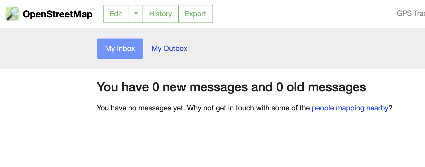
Here’s a recent change I made to implement Andy Allan’s suggestion for improved inbox/outbox navigation, using Bootstrap navigation tabs in place of plain links. This small design tweak is now live on OSM.org My Messages:

new Inbox image

Contrast this with the old look, with simple HTML links in the page header that don’t quite look like usable navigation:

See full entry

Location: Downtown, Downtown Oakland, Oakland, Alameda County, California, 94612, United States
Posted by c tito young on 22 March 2021 in English. Last updated on 10 April 2021.

A geoglyph pointing southwest is of a bird in flight (50m x 50m). The sideview shows the body with a tail, one wing and one eye, and a beak. Below the bird is another geoglyph (25m x 5m) but very hard to tell what it is, pointed in the same direction. He is drawn on the tip of a bluff and likely visible from the ground or sky.

14°44′24″S, 75°12′27″W -14.7400748, -75.2074830 El Ingenio, Province of Nasca, Ica, Peru

Location: El Ingenio, Province of Nasca, Ica, 11350, Peru
Posted by gszkr on 21 March 2021 in Polish (Polski). Last updated on 16 May 2022.

W ostatnim czasie pojawia się wiele zdublowanych przystanków, gdzie poza oznaczeniem na chodniku funkcjonuje drugie oznaczenie miejca zatrzymania na jezdni. Tymczasem jak mówi Wiki public_transport=stop_position W większości przypadków jest to zbędne, ponieważ jest to po prostu miejsce na drodze najmniej odległe od highway=bus_stop (dla autobusów) czy tor tramwajowy najmniej odległy od railway=tram_stop (dla tramwajów). Pod linkiem w Wiki również szerszy komentarz.

Edit: wpis na wiki został zmieniony przez usunięcie fragmentu zaczynającego się od “W większości przypadków jest to zbędne(…)”

Dyskusja na ten temat miała też miejsce na grupie OpenStreetMap Polska (Poland)

The Proposal

In late 2020, I drafted a proposal to introduce a common format for the name=* tag in the Republic of Srpska, a territorial subdivision of Bosnia and Herzegovina (BiH). The reasons were mainly general data inconsistency and recurring edit wars. There are two official scripts in the Republika Srpska, Latin and Cyrillic, both of which are in active use. Moreover, some mappers (as well as members of the general public) consider the usage of either or both of the two scripts a political tool and/or an instrument of nationalist propaganda. This means that it is hard to reach a consensus as to what the name=* format should be. It can be argued that a tag like name=Бања Лука is violating the On-the-Ground Rule because both scripts - not just Cyrillic - are official. It can also be argued that a tag such as name=Banja Luka / Бања Лука violates the OTG Rule because the city is not called “Banja Luka Slash Banja Luka” or because one of the scripts is “more official” than the other and should therefore be listed first. Therefore, I included several possible name formats in my proposal and invited the members of the OSM community in BiH to vote for the most suitable one with the intention to propose the winning format “officially” to the worldwide OSM community. The voting took place on the proposal’s discussion page.

The Response

I have contacted 55 mappers in total, most of whom were my saved private message contacts with whom I have corresponded over more than 4 years of consistently reaching out to BiH users, others were top-ranking mappers recently active in the country. As you can see on the proposal discussion/voting page linked above, the response was rather underwhelming, with many of the most active users ignoring the communication and the vote completely.

See full entry

Posted by SekeRob on 20 March 2021 in English.

After doing this intensely for 8 months, constant COVID-19 lockup, it’s depressing how poor the quality, but foremost the tag completeness is. At times it’s like boxcars. There’s many who never seem to follow up on their issues left behind, unconnected ways, routers, they don’t understand 2 end nodes 1 meter apart… there’s no way for them to go from one to the other. We plod on though and keep witteling away at it. Both the navigators I use are OSM data based so whatever I can resolve along the ways I traverse, helps me plotting the next long distance cycle tours in particular… is it up or down, the angle, what quality is the surface, yes here in Abruzzo it’s not a given, many cracks and potholes… cost me 2 wheel rims already so recently switched to 2.5 inch wide rubber wheeled bike… much more conformable. Keep going.

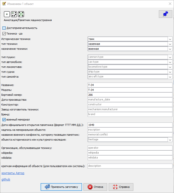
Памятников машиностроения - Заготовка тегов для JOSM

Основана на OSM вики страницах: 1 , 2 , 3 , 4 , 5, 6, 7 и часто используемых тегов в OSM сообществе.

Языки заготовки: Русский, Українська мова, Беларуская мова, Deutsch, Français,

technics.png

ссылка для скачивания заготовки https://github.com/Sowa1980/technics_preset

Подключить заготовку тегов в JOSM можно, запустите JOSM: далее в меню “Правка” выберите пункт “Настройки” или нажмите (F12) в открывшемся окне с лева выберите икону “Параметры проекции” (третье сверху) откроется окно “Настройки карты” далее перейти на вкладку “Заготовки тегов” в правой стороне нажмите на+, в открывшемся новом окне в строке “Название (необязательно)” задайте желаемое имя в строке “URL / файл” укажите путь до скаченного файла (формат файла должен быть *.xml или *.zip).

Приму замечания и пожелания по заготовке, переводам и тегам, если знаете более точное название как будет звучать на любом языке исправлю, пишите. обсуждение в группе https://t.me/OSM_BelRusUkr

See full entry

Bonjour !

Si je vous ai “ajouté en tant qu’amis” sur osm c’est pour une raison simple. Je pense que nous pourrions créer un petit groupe de contributeurs osm autour de l’agglomération d’Annecy.

Intérêts

Globalement, je pense que c’est utile parce que je sais que c’est quelque chose qui me motivera à m’impliquer plus et mieux. J’espère donc que ça pourrait être le cas pour tous les membres et même ceux qui sont déjà de gros contributeurs à la plateforme.

Comment ?

Que vous soyez intéressés ou non, je vous propose d’abord de m’envoyer un message privé si vous lisez ce message. En précisant si vous êtes intéressé :) Comme ça j’aurais bien un accusé de votre lecture.

Et ensuite ?

Et bien on discutera tous ensemble et on pourra prévoir de sortir en groupe ou discuter ensemble des manières de chacun de techniques, etc…

Voilà

Pour toute remarque, commentaire, question, insultes… N’hésitez pas, je suis à l’écoute

Recentemente fiz a importação dos cursos de água da ANA (Agência Nacional de Águas) para o Piauí. O Estado estava com uma deficiência imensa de recursos hídricos no OSM. Claro que agora, após a importação desses dados, o desafio é fazer o alinhamento desses rios e riachos, corrigir cruzamentos entre vias, etc. Ou seja, melhorar ainda mais.

Também estou fazendo ajustes nos limites municipais no Piauí. Os limites municipais no Estado, muitos estão desatualizados. Muitos municípios estavam ainda com dados do senso de 2010, sendo que houveram várias mudanças nos limites de alguns municípios de 2012 até 2019. Estou fazendo estas mudanças de acordo com essas atualizações do IBGE. Estou fazendo melhorias nas relações, onde estou integrando recursos hídricos, vias, etc. Que fazem parte desses limites, com muito cuidado e responsabilidade.

É um longo trabalho, mas que é bem gratificante!

Abraços galera.

HOT is setting up a new regional hub structure globally (see previous posts), and with the two new hub directors Nama Budathoki (Regional Director: Asia-Pacific) Monica Nthiga (Regional Director: East Africa), and Head of Community Pete Masters we’ve been pondering what they should be called.

Why is this important?

  • We want to signify some of the values of what the hubs should be in the name, to signal what a hub stands for. The name should indicate that it is an open and participatory space for communities to engage with. More on hub principles here.
  • We also need to communicate what the hubs do not stand for; that this is not a HOT country office, nor do we want it to be.
  • The hub work is only just beginning; now is a great time to choose a name which indicates what the hub could be for communities that have not yet engaged with OpenStreetMap at all. The name should help connect these communities with what to expect from the hub.
  • The word “humanitarian” is not applicable to all of the locations and contexts the hubs serve, and does not resonate with many OpenStreetMap communities globally. Using HOT’s acronym could be useful to signal that the hubs are related to HOT, but the word humanitarian may be less so.
  • Building awareness is really hard, and so it would be easier if the hubs share a commonality in their naming, that is, we don’t have four different hubs with four completely different names

What’s not possible?

  • Several people have suggested we could use OpenStreetMap hub or OSM hub - unfortunately that’s not allowable under the current trademark agreement that’s coordinated between the HOT & OSMF Boards.

Idea for a formula:

What do we need to include?

  1. The region (Asia Pacific, East Africa, West Africa, Latin America & Caribbean)
  2. A link to HOT; how do we identify these open mapping spaces are supported by HOT?
  3. Something about the nature of the space; what is it?

Some examples of ideas (using Asia Pacific region as an example):

See full entry

Location: Crystal Palace, London Borough of Bromley, Greater London, England, SE19 2GA, United Kingdom
Posted by dcapillae on 18 March 2021 in Spanish (Español). Last updated on 5 July 2024.

Estoy confeccionando un mapa interactivo con el trazado y restos conocidos de la antigua muralla medieval de Málaga. Todavía no está completo, aún estoy trabajando en él, mejorando las descripciones, incluyendo referencias y añadiendo algunas fotos. También completando la información que falta y corrigiendo errores.

Los datos del mapa estarán disponibles bajo condiciones de Licencia Abierta de Base de Datos, por lo que se podrán descargar y reutilizar libremente. Las imágenes las estoy subiendo a Commons, así que también se podrán descargar y reutilizar libremente.

Mapa interactivo de la muralla medieval de Málaga Captura de pantalla de una de las primeras versiones del mapa interactivo con el trazado y restos conocidos de la antigua muralla medieval de Málaga. Fuente: trabajo propio (CC BY-SA 4.0), teselas de CartoDB (CC BY 3.0), datos de colaboradores de OpenStreetMap (ODbL).

P. D. (2021-03-28): El mapa interactivo de la muralla medieval de Málaga apareció en el número 557 del semanario de OSM.

Location: Centro Histórico, Centro, Málaga, Málaga-Costa del Sol, Málaga, Andalucía, España

Некоторое время назад я начал описывать свой процесс сбора и ввода данных о POI. Само описание ещё далеко от завершения, хотя часть продолжения уже давно написана, но не опубликована. Там ещё много чего надо отредактировать, потом я решил написать другую запись покороче, но она получилась втрое длиннее последней записи про POI, и теперь я не знаю, когда доделаю и её. Сейчас я напишу кое-что на самом деле покороче.

Как и его описание, сам процесс обновления POI идёт с тормозами. Одна из очевидных причин этого — его двухэтапность.1 Сначала я иду на место и собираю там информацию о POI. Потом я иду за комп и ввожу собранную информацию. Это «потом» может наступить весьма потом или не наступить вовсе. Последнее происходит, когда данные достаточно устаревают из-за длительного срока с момента сбора или каких-либо существенных событий. Например, сейчас мне придётся выбросить данные, собранные осенью 2020 года. Летом того же года мне пришлось выбросить всё собранное до коронавируса.

Конечно, есть средства, позволяющие минимизировать количество возможных конфликтов от ввода старых данных, но сейчас я собираюсь написать не о них, так что вернёмся к двухэтапности. Двухэтапность это, вроде бы, плохо. Если бы я сразу вводил выясняемую на месте информацию, процесс шёл бы быстрее и с меньшим количеством потерь. И у нас же есть средства для ввода POI сразу, например, плагин редактирования в OsmAnd. Почему я им не пользуюсь?

Полунаписанная запись про особенности редактирования из OsmAnd у меня тоже есть в черновиках. Аналогичная ей про MAPS.ME уже давно написана. В ней в основном говорится о чужих правках, которые нам могут попасться, как они объясняются и что с ними делать. Сейчас же мы посмотрим на редактирование из OsmAnd с другой стороны — с сугубо практической для нас, на конкретном примере.

Конкретный пример

See full entry

Posted by joost schouppe on 16 March 2021 in English.

The reason I’m writing this post is that my first MapComplete theme got merged into the official version. Yay! But first, an introduction.

Introduction

Having been freed from most OSMF duties, I got a bit of an OSM reboot as of late. I became more active in Belgium, where OSM seems to be booming. More people want to be involved, many more people care about what is on the map.

One of the projects that have made this a fun time, is MapComplete. I was always very enthused by projects like MapContrib - because they make it easy to create detailed thematic maps, while also being an editor for that specific theme.

I really believe thematic editors are the way forward for OpenStreetMap. Most of us here are people who care about “the map in general” (or at least a wide range of mappy topics). But most “normal” people don’t care enough about OSM data to invest in learning to use a fully fledged editor. Yet they might care more about data they really need - like whether they can store their bicycle safely, or if the power outlet is right to charge their car. Or they might be passionate about certain topics, like accessibility of paths in their neighborhood, public fruit trees, handicapped parking spots.

MapComplete is built to bring those people to OSM, instead of the plethora of POI databases that exist today. If you want to introduce MapComplete to non-OSM people, have a look at the project page on OSM.be (en, nl, fr). The project was started by PieterVDVN for a project to map the accessibility of neighborhood nature. During Open Summer of Code we expanded on it for the Brussels Region. Flemish municipalities are interested in it as well.

See full entry

Posted by ottwiz on 16 March 2021 in English. Last updated on 25 March 2021.

Rákospalota sometimes has dumb addressing like

Sződliget utca 30, 34, 32, 36

or Mátyás utca 64/a 64/b 64 64/c

Aporháza utca 13-15, 13, 17, 17-19, 19, 29 (i mean, what the hell)

and i could list it all the way along, but it wouldn’t make any sense. Also, the area has outdated imagery, today I discovered there is a dog park behind Énekes utca 19-35 apartment block, which is not on neither of the imageries available here, because it’s so new. I mean, I made a lot of photos for surveying purposes but I wish there was a 2020 imagery in my area. I think i’m mostly done with my area, it was a VERY hard work, and there is still housenumbers missing in the 15th district, but because of me, i did around 25-30% of it, and I’m proud of it. :)

Location: Rákospalota Öregfalu, Rákospalota, 15th district, Budapest, Central Hungary, Hungary