Diary Entries in English

Recent diary entries

Peter Mooney, Frank Ostermann and I first met at a workshop about Crowdsourcing in National Mapping in Leuven. There were people from national mapping agencies from around Europe, who came to talk about their experience with working with crowdsourcing. I talked about the crowdsourcer’s perspective. It was a bit frustrating to be the only OSM-community representative, as I know that we’re defined by many points of views. With Peter and Frank the conversation soon went to the science aspect of that same relation. Professional scientists find it hard to talk to OSM, and OSM people find it hard to talk to scientists. We believe we can do better. And we want to do something about it. Rather than just start doing stuff, we want to invite you to discuss this with us. Below is our line of thinking, written by the three of us together.

Problem

This initiative is based on our observations that there is room for improvement in the interactions between the academic research and OSM communities. On the one hand, the OSM community often learns late (or never) about research results generated from academic research on OSM. For example, the OSM wiki pages on academic research are likely not to be up-to-date (with the majority of entries from the years 2010/2011, and little after 2014), but nevertheless quite cluttered, containing many non-English entries, and therefore difficult to search effectively. On the other hand, the academic research community has often little information on what are important concerns for the OSM community. As a result, very often academic research is carried out on OSM in complete isolation from the OSM community itself. There has been substantial interest from the academic research community into OSM since at least 2006/2007. This interest shows no signs of abating. One must acknowledge that the incredible success story of OSM is an intriguing source of potential research for academics.

Objective:

Our initiative has therefore two main objectives:

See full entry

I noticed that the wiki describes City, Town, Village and Locality to be named based on a determined size.

Example: Use place=town to identify an important urban centre that is larger than a place=village, smaller than a place=city, and not a place=suburb. Towns normally have a good range of shops and facilities which are used by people from nearby villages.

My suggestion is that includes the local legal/administrative size denomination. Many countries have a legal/administrative approved size for naming for City, Town, Village, Locality.

Many new mappers will mistake similar classifications when mapping new features. For example, when I first started mapping, I would mark areas as “forest”, when I meant “wood”. I also marked “meadow” instead of “grass” in many places. Others confuse “footpath” and “path”, “residential area” and “apartments”, and “nature preserve” and “park”. If OpenStreetMap could add a pop-up that would say “did you mean” followed by a similar tag to the one that the mapper just selected and a comparison of the two tags, then new mappers could more accurately map areas.

First of all, thank you for participating to SotM 2017 Aizuwakmatsu!

Unfortunately I was not able to talk to every persons due to my staff work, but I could talk with Arun following idea. I would like to hear more broader suggestions & feedback.

Motivation

To establish peer review operation workflow especially regarding newbie mappers.

Approach & Tools

OSMCha has feature to detect specific #hashtag on changeset comments or specific tags on changeset. So my main idea to encourage mappers to add special meta data to the changeset if he/she want the edits to be peer reviewed. I guess it is possible to add comments e.g. #needreview on special changeset comment or need_review=yes or other information on changeset tag.

If those tags are set, it maybe possible to detect such a message through OSMCha easily.

Idea for iD Editor integration

Yes, it is too difficult to encourage newbie mappers to add such a information. Because they are a previous stage to understand how those messages are important.

So my suggestion to add a function to iD editor. At the commit (save) screen on iD, it is set a checkbox Need Review or Ask someone to Review to add above hashtag or changeset tags.

See full entry

The OpenStreetMap Latin American community communicates constantly in a Telegram chat in addition to other social networks, on technical issues, methodological challenges or local communities dynamics, projects, achievements, sometimes opinion debates, etc. The dialogue has led subgroups to form, as Geochicas last fall 2016, and collective projects to emerge around a conjuncture or a shared interest. A chat allows everybody to join a dynamic in process. Integrating, learning along the way or just observing, soaking up, and also identifying as a community. I think the anniversary mapathon was a great opportunity for this in the LATAM community.

A happy coincidence led this community to plan a continental scale mapathon, on the occasion of the 13th anniversary of OpenStreetMap.

From Mexico, after 2 years of repeated massive training efforts in universities and other civil and government communities, the tendency of the OSM Mex group is to make a pause and dedicate more, for a time, to the improvement of the map through remote mapathon promoted in the existing community.

On the other hand the group Geochicas, from their debates on the different ways to produce information and improve the database of OpenStreetMap in a sense that benefits women, and taking advantage of these activities to empower women in the community, we also decided a few months back to organize at some point a large remote mapathon on areas where women experience an acute level of vulnerability. Vulnerable areas, in general, would benefit from mapping and women, in particular, would receive an even greater impact as a result of overall improvement of information, as well as promoting a parallel and permanent mapping of equipment and points of interest considered useful for women. This second category of data, being more difficult to collect without a fine local knowledge, it seemed more feasible to organize a general mapathon of vulnerable settlements.

See full entry

Location: Algarín, Mexico City, Cuauhtémoc, Mexico City, 06880, Mexico
Posted by dmgroom_ct on 22 August 2017 in English.

For the last few weeks I’ve been improving the data for the Kashmir Valley.

Have improved the accuracy of the forested areas, which previously were drawn in very low resolution, and often incorrectly included large parts of non-forested land. I may have included some areas of scrubland within the forested areas, it’s sometimes difficult to differentiate from the imagery.

Now working on highways. have been genuinely surprised at just how many highways and tracks there are in the area.

Location: Bonichakal, Pattan, Baramulla, Jammu and Kashmir, India
Posted by -karlos- on 21 August 2017 in English.

OSMgo-stop

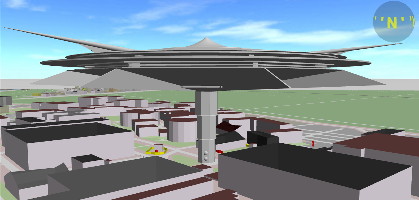
The development of OSMgo is on hold, may be forever. It was not intended to go that far anyway. I will do small changes now or then. And “support”: If anyone tells me new bugs or a missing feature, I most probably will get active. If you like to use OSMgo with a liddle help, I would be glad to guide you in multiuser mode. My friend Martin is coding a plane control/simulation. Soon you may fly through the virtual 3D world of OSM with/as a model plane. When the intended 3D model server/repository is online, it will be used by OSMgo to.

See full entry

Posted by Johnny Mapperseed on 19 August 2017 in English. Last updated on 8 August 2018.

Edit: This list is pretty out of date, and I have a different perspective of things now. I’ll update this later.

  1. Armchair Mapping Mistakes
  • Thinking that going to a place and coming back to your home to actually make the change in OpenStreetMap instead of doing it on the spot is “Armchair Mapping” and not a survey.

  • When actually armchair mapping, assuming that just because something was there in my childhood, that it still would be there and unchanged.

  • Trusting satellite imagery more then my own eyes. Ground truth matters. If you think satellite imagery is going to be out of date for a long time in an area and it doesn’t reflect ground truth, it’s best to leave a note as a separate node or area explaining such so you dont forget and “Correct” you factual edits. Be sure to leave a date in your note for easy reference.

  • Not correcting misaligned satellite imagery with GPS traces whenever it is appropriate.

  1. Surveying Mistakes

See full entry

Location: The Village, Bowling Green, Wood County, Ohio, 43402, United States
Posted by scruss on 19 August 2017 in English.

Something in the weekly newsletter caught my eye:

Miguel Sevilla Callejo (msevilla00) from Zaragoza, Spain, is currently in Wales. He noticed an inconsistent use of English and Welsh in OpenStreetMap. His email resulted in a readable, long-lasting and controversial discussion on the Talk-GB mailing list (threads in July and August) and comments in an OSM changeset. Nearly the same problem in Switzerland – read the following article. 😉

http://www.weeklyosm.eu/archives/9374

Miguel Sevilla Callejo (msevilla00) de Saragosse, en Espagne, est actuellement au pays de Galles. Il remarque une utilisation pas toujours cohérente de l’anglais et du gallois dans OpenStreetMap. Son courriel a donné lieu à une longue et controversée discussion sur la liste Talk-GB (juillet et août) et des commentaires dans un changeset OSM. Presque le même problème en Suisse – Lisez l’article suivant. 😉

http://www.weeklyosm.eu/fr/archives/9374

So I went to the “Multilingual names” page https://wiki.openstreetmap.org/wiki/Multilingual_names and found Canada conspicuously absent. Is this because:

  1. we’re already doing it perfectly in Canada; or
  2. local mappers already know what they’re doing (an argument that seemed to be dismissed in the original discussion about Wales); or
  3. nope nope nope not touching that with a rad-hardened barge pole?
Posted by juminet on 18 August 2017 in English. Last updated on 28 December 2017.

Here’s my list of some scientific articles on OSM that I might read once retired:

  • Schultz, M., Voss, J., Auer, M., Carter, S., & Zipf, A. (2017). Open land cover from OpenStreetMap and remote sensing. International Journal of Applied Earth Observation and Geoinformation, 63, 206-213.

  • Neis, P., & Zipf, A. (2012). Analyzing the contributor activity of a volunteered geographic information project—The case of OpenStreetMap. ISPRS International Journal of Geo-Information, 1(2), 146-165.

  • Neis, P., & Zielstra, D. (2014). Recent developments and future trends in volunteered geographic information research: The case of OpenStreetMap. Future Internet, 6(1), 76-106.

  • Senaratne, H., Mobasheri, A., Ali, A. L., Capineri, C., & Haklay, M. (2017). A review of volunteered geographic information quality assessment methods. International Journal of Geographical Information Science, 31(1), 139-167.

  • Barrington-Leigh, C., & Millard-Ball, A. (2017). The world’s user-generated road map is more than 80% complete. PloS one, 12(8), e0180698.

  • Geographic Biases are ‘Born, not Made’: Exploring Contributors’ Spatiotemporal Behavior in OpenStreetMap, http://www.brenthecht.com/publications/group2018_spatialfootprints.pdf

Posted by Polyglot on 17 August 2017 in English.

Over the past few years, I’ve been mapping a lot of bus stops and routes. Over the past few months I’ve been looking around how it’s done in other places around the world.

What I find (this may of course be influenced by what I wanted to find) is that most bus stops start out as a node next to the way, tagged highway=bus_stop, usually with a name on it.

Then somebody comes along, who glues it to the way. Then somebody else comes along who maps a platform next to the way, using a way, copying all the tags over. They do this regardless of the whether a platform actually exists. They think they need this to add 2 objects per stop to the route relations. Somehow the wiki convinces them of the need for this.

Mapping platforms as ways where there aren’t actual platforms feels wrong to me. Adding a set of details to more than one object also doesn’t feel like the most sensible thing to do. Adding 2 objects to each route relation for 1 real life object makes working with these route relations harder to do.

I’d like to see that a casual mapper can start out mapping a bus stop as a node next to the way, as highway=bus_stop.

Possibly they add public_transport=platform to this node. It seems odd to do so, even if no platform is there, but that’s how things evolved. Tagging it as public_transport=platform means that a role platform will be assigned to it in the route relation. (if the route relation has public_transpot:version=2). It’s the answer I got when I asked the question a few years back on the mailing list. I usually put that node more or less where the pole is. But the exact position is not all that important, as long as it’s more or less where passengers will be waiting.

See full entry

Posted by MikeN on 16 August 2017 in English.

Out of curiosity, I pulled some statistics on the US Rail network. This does cross into a bit of Canada and Mexico where the GeoFabrik extract approximated the boundary.

level_crossing	TOTAL	232167
crossing	TOTAL	8231

Rail_Bridge	47232
Rail_Tunnel	16394
Highway_Bridge	70811
Highway_Tunnel	8972

Total Layer Crossings 143409

A bridge or tunnel is counted as a single occurrence no matter how many rail lines are included. Each marked crossing node is counted, so a fully mapped rail yard could contain many crossing nodes.

For a closer look here is a breakdown of the top 20 categories of level_crossing - the first column is the type of ‘highway’, and the second column is the type of ‘railway’ in OSM:

residential	rail	112659
service	rail	29171
tertiary	rail	26789
secondary	rail	16717
unclassified	rail	12732
track	rail	10058
primary	rail	6734
residential	disused	1628
residential	light_rail	1547
residential	tram	1413
trunk	rail	1122
tertiary	light_rail	1114
secondary	light_rail	1059
service	light_rail	676
residential	abandoned	660
primary	light_rail	517
tertiary	tram	493
service	disused	435
tertiary	disused	372
residential	Unknown	371
residential	preserved	353

A type of ‘Unknown’ usually means that a node that joins ‘highway’ to ‘highway’ is marked as type level_crossing for example.

Similarly, here are the top 10 ‘crossing’ types:

footway	rail	2984
footway	light_rail	2083
path	rail	881
cycleway	rail	762
footway	tram	565
path	light_rail	116
cycleway	light_rail	96
footway	miniature	86
footway	preserved	62
residential	rail	56
service	rail	34

Note the presence of ‘residential’ and ‘service’ which are either newly incorrectly marked ‘crossing’s or a rail crossing at the junction of ‘residential’ and ‘path’ for example.

To see the complete breakdown to perform custom category groupings, obtain the raw .CSV files from Rail Crossing Counts

The Mayor and City Council of Baltimore acted swiftly after violence at the Unite the Right rally in Charlottesville, Va. led to a national conversation on the removal of Confederate monuments. The protests centered around the removal of prominent Confederate generals’ monuments in that city. In Baltimore, the City Council passed a bill that permitting the removal of four Baltimore monuments to the Confederacy. The mayor executed the order by contacting local firms to remove the four Confederate monuments in Baltimore during the night of August 15, 2017, into the following morning.

Imgur

OpenStreetMap is a database of physical features. Since the four monuments are no longer physically present, I have removed them from OpenStreetMap. The removed statues include the Roger B. Taney Monument, the Lee-Jackson Monument, the Confederate Soldiers and Sailors Monument, and the Confederate Women’s Monument.

Location: Northwood, Baltimore, Maryland, 21251, United States

Weekend before last I spent several hours roaming Abadan and Gypjak, far western suburbs of Ashgabat, collecting street names, points of interest, and adding streets that didn’t appear on the map (unplugging the SD card from the Garmin navigator forces it to collect tracks where you actually are, rather than trying to align them to the nearest street). Those towns, while not yet complete, are in much better shape in OSM now.

The research continued on names of monuments in traffic circles within the Ashgabat city limits. I count 22 monuments inside traffic circles and believe we now have names for all of them. If you are curious, enter “binasy, Ashgabat” or “monument, Ashgabat” in the OSM search box (without the quotation marks) and see what pops up.

Construction in Ashgabat is winding down as the Asian Indoor and Martial Arts Games approach. They start September 17 and the city is preparing.

Location: Yasmansalyk, Bagtyyarlyk District, Ashgabat, Turkmenistan

This Friday, I will be at SOTM in Aizuwakamatsu, Fukushima this weekend talking about the state of validation on OpenStreetMap! I will talk about the need for making a validated error free map with OSM data, the recent efforts of the Mapbox Data team to review OSM changes and what the future of data validation might look like. If you are interested to attend the talk, grab a seat in the main hall at 4:10pm on Friday at the Aizuwakamatsu City Culture Center.

If you are interested in a deep-dive into validating edits in your area on OpenStreetMap, attend Validating the Map workshop conducted by manoharuss on Sunday at 1:30pm in Room-1.

image

_Distribution of reviewed and validated changesets using OSMCha in 2017 View Interactive Map_
Posted by SomeoneElse on 15 August 2017 in English. Last updated on 11 August 2021.

There’s recently been a thread on the talk-gb mailing list where someone has decided that, despite previous custom and practice there, the “name” field in both English- and Welsh-speaking areas of Wales should be a compound of both the English and Welsh names. No-one says “I’m climbing up Snowdon / Yr Wyddfa today”, they’ll use one name or the other, not both together.

In the Welsh-speaking areas the Welsh names are more likely to be used; in the English-speaking areas the English names. It’s not a hard-and-fast rule; this peak in the Black Mountains is referred to about equally by both the Welsh and English names, despite it being in a predominantly English-speaking area.

Wikipedia gives an idea of Welsh-language take-up here. That’s a bit broad-brush; for example I don’t think there’s an isogloss between Carmarthenshire and Swansea where people gain/lose the ability to speak Welsh.

So how is it possible to extract data from OSM with the Welsh name in the Welsh-speaking areas and the English name in English-speaking ones, both when creating e.g. a rendering database for the first time and when updating it as people update OSM? Firstly we’ll just consider the “loading the database” part.

There are a couple of possible solutions to the problem. I used “osmosis”, which has a handy “tag transform” feature. The Welsh one is here; the English one is similar.

Very roughly, the Welsh-speaking area of Wales corresponds to this area. That’s not perfect, but it’s not a bad approximation for a rectangle. I downloaded the latest Welsh data from Geofabrik and cut that area out of it:

osmosis  --read-pbf wales-latest.osm.pbf  --bounding-box left=-4.82 bottom=52.02 right=-3.34 top=53.69 --write-pbf wales_cy_before.pbf

Convert the “Welsh-speaking” part to names based on “name:cy”:

osmosis --read-pbf wales_cy_before.pbf --tag-transform transform_cy.xml --write-pbf wales_cy_after.pbf      

Create a copy of the larger file with names based on “name:en”:

See full entry

Location: Llanigon, Powys, Wales, United Kingdom

For those that have check my previous tutorials, are aware of the benefits of using Mapillary imagery (especially the traffic signs detections), however some crosswalks don’t have traffic signs nearby. By using Mapillary AI we are able to detect them fast and add them to OSM. Here’s the video tutorial how you can use AI Detections for OSM.

Find out more about Mapillary AI Detections

My previous tutorials: ID Editor and JOSM

AI Detections

Location: Faial, Santana, Madeira, Portugal

The end of the 2017 Google Summer of Code is getting closer. In the last weeks I was working on styling the map.

The most challenging task this month was definitely the anti-aliased ways, and I ended up doing that with the help of barycentric coordinates. I also added borders to areas and paths. I did a mistake previously, and not all buildings were visible, but I have fixed that issue, and now small buildings are also visible.

There is still some work to do, I intend to concentrate on the obvious things in the next day. Looking at the pictures below one can see that dotted/stippled lines are not yet supported (in the first picture the tiny red lines should be dotted). Fixing the looks of the texts also have high priority. The size is not quite right, and it is blurry. I also want to add support for patterns before the GSoC ends.

Debrecen: Debrecen

See full entry

Location: Egyetemváros, Debrecen, Debreceni járás, Hajdú-Bihar, North Great Plain, Great Plain and North, 4032, Hungary