 OpenStreetMap

I was wondering how to revert an edit made on political bias. This user deleted the majority SeaWorld Orlando but the rest of their edits look to on the up and up. Change set: 50681538
Diary Entries in English
Recent diary entries
Posted by amb_santacruz on 13 August 2017 in English.
Chris Barrington-Leigh and I have been working for the past few years to assess the completeness of the street network in OSM. We’re pleased to have now published our results in the journal PLoS ONE. Thanks to many suggestions from the OSM community on our preliminary analysis.
Here are the highlights from the paper’s abstract:
We find (i) that globally, OSM is ∼83% complete [as of January 2016], and more than 40% of countries—including several in the developing world—have a fully mapped street network; (ii) that well-governed countries with good Internet access tend to be more complete, and that completeness has a U-shaped relationship with population density—both sparsely populated areas and dense cities are the best mapped; and (iii) that existing global datasets used by the World Bank undercount roads by more than 30%.
An update using the April 2017 snapshot suggests that completeness is now ~89%. Our more detailed results and all our code are available on GitHub. Here’s a sample of the largest 10 countries (updated through 2017), showing the actual growth in OSM road length and our model fits: ![Growth in OSM dataset] (https://people.ucsc.edu/~adammb/Documents/fitted-top10best.jpg)
And here’s the fraction complete, also updated through April 2017: ![Fraction complete map] (https://people.ucsc.edu/~adammb/Documents/OSMmap-frcComplete_best.svg)

out there is trying to run Vespucci 0.7.0 which dates back to April 2011 on a Xiaomi Redmi Note 4 with Android 6.0.
While the app will run, 0.7.0 was released a while before 64bits for OSM element ids became necessary (early 2013), and trying to parse current data will lead to a crash.
With other words: please upgrade to a current version!
Thank you

THIS FEATURE IS NOW OFFICIALLY AVAILABLE IN OVERPASS API 0.7.55
Again a bit of prototyping today.
I always wondered what the best way to download all objects along some GPX track (more generally a list of lat/lon pairs) in Overpass API might be.
Usually, you don’t want to create some complex poly-filter for this, or even worse upload your gpx track as OSM way just for the sake of finding out what’s close by.
You might have come across the around filter, which comes in handy to find objects around a center point. I have extended this idea a bit to also handle linestrings.
Here’s a first result: a turquoise circle in the middle is our great made up GPX track, consisting of about 20 points. All the yellow stuff in the background is what Overpass API returned as highways up to 500m away from our circle. Obviously, that circle doesn’t exist in OSM, so we’re really looking at what’s close to our virtual way.
Circle

Live demo: http://overpass-turbo.eu/s/yt2
Road trip


A turn-restriction defines restricted or mandatory turns at a junction and are one of the most important features to map for accurate driving directions. Thought I would quickly make a comparison of how different map data editors visually represent this feature for mappers. Pick the best:


Add me now ! Cwassim87 👻👻👻👻
Posted by baditaflorin on 10 August 2017 in English.
Yesterday we had our anniversary OSM Time meetup, where we celebrated 13th years of OSM, and we also had a workshop for the participants, to learn how they can extract information’s from OSM, using overpass API and overpass-turbo.


Malaria in Zimbabwe - HOT
Many organizations have collaborated together in the “Malaria Elimination Mapping Campaign”. This campaign seeks to create data to help eliminate malaria in affected countries in Africa, Asia and Central America.
Mapbox has helped in various ways with visualization, coordination, communication and validation of building data. Validation was done to improve data quality in the areas where these tasks were activated.
The “To-fix” tool is used to detect errors and we use Digital Globe and Bing satellite imagery to confirm mapped buildings.
You are invited to use “To-fix”, it is very easy to use and easy to download.
List of detected errors:
- Overlapping buildings
- Crossing buildings
- Buildings that do not exist in the DG or Bing Imagery
 Overlapping buildings
Are you bored of looking at your neighbourhood in OSM, trying to find the last unmapped tree, the last sidewalk still left to be drawn? Are you tired of trying to come up with even more complex relations so that landuse near your town is perfectly represented with multipolygons? Are you getting cross-eyed with the galaxy of POIs in your nearest city centre?
Wouldn’t you prefer the thrill of being the first person to put entire villages and towns on the map? Discovering hundreds of kilometers of new roads, never before touched by OSM? Or relaxingly drawing completely rivers and canals, shooting straight across open plains?
If only the frontier was still open. If only there was such a place of vast possibilities. If only there was somewhere where life, pardon me, mapping, was still simple, honest, and true. Well, fear not! Such a place does exist. Come join us over at WikiProject_Iraq and talk-iq and claim your place among the pioneers.
Just look what you can do. No features visible on these images are drawn AT ALL:
The group of railroad crossing challenges listed in the previous diary entries is now complete. Many people worked on these challenges to make this happen. The tasks seemed to get more difficult as the challenge neared completion, since each task would correct a single crossing at a time.
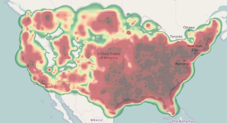
Many of the tasks involved original TIGER highway crossings with poor alignment. I also worked on geometric alignment of the crossing approach roads to match the aerial imagery. Although almost none of these would be cross-checked against GPS traces, Bing imagery is almost always a factor of 10 more precise than the worst of the TIGER data. The resulting edits may have an effect on “TIGER desert analysis” - the study of large untouched areas in the US. Those “TIGER deserts” still exist but would be smaller. My personal contributions heat map now mostly shows areas in the US where there were rail crossings that needed fixing:
Posted by PanierAvide on 6 August 2017 in English.
Last updated on 20 June 2019.

Summary (TL;DR)
Pic4Carto is a great tool for finding lot of urban features using street-level pictures. I was able to add some vending machines remotely, in Aizu-Wakamatsu (where the next State of the Map 2017 will happen). This map (made with MapContrib) shows all the machines in the city.
Context
You might know that soon the annual OpenStreetMap conference will take place in Aizu-Wakamatsu. As some other lucky mappers, I’m going to this amazing event (thanks to the French OSM association) and give a talk about a tool I’ve made called Pic4Carto. This post is a real-world example of what can be achieved using this tool.
I’ve been last year to Tokyo, it was such an amazing trip. Japanese people and culture are so great. I was amused by the amount of vending machines you can find in the city. Here in France, we have only a few vending machines, and most of them are indoors. So seeing a bunch of machines pretty everywhere was really fun.


Came across a brochure today naming some previously names-not-known monuments in Ashgabat, so did a little ground truth to verify them and entered their names (no, the brochure does not bear a copyright!) Also added a kindergarten, updated some streets, added one (1) street name discovered while exploring a neighborhood to discern changed traffic patterns. There are still street names to be discovered but these days instead of collecting a dozen or two dozen on a trip, I’m lucky to find one new street name.
CC 215 may have been shifted onto a new alignment today as part of a big construction project. I edited the map for this. If not now, it will be soon.

A couple of weeks ago I posted a diary entry introducing myself, my interests in OSM and showcasing an upcoming survey for OSM editors. I am very pleased to announce that the survey is now live and I would like to invite as many OSM editors as possible, to participate. The survey is anonymous and only takes a couple of minutes to complete.
The project is motivated by recent research that has found a strong male bias in OSM participation. This has led to assertions that various geospatial knowledge could be under represented or poorly recorded on the map. However, the actual consequences of this bias remain little explored or reported. By collecting information about contributors to OSM, which can then be analyzed along with their editing patterns, the impacts of this bias might begin to be measured and therefore better understood.
If you are interested in or would like to participate in the study, please click on the link below, which will take you to the Bristol Online Survey website where you will find more information and an opportunity to participate in the survey. As a small incentive, at the close of the survey in a few weeks’ time, 60 respondents will be drawn at random to receive a £15 Amazon voucher.
To participate in the survey, click on the link below:
https://nottingham.onlinesurveys.ac.uk/osm-user-profiles
Please do think about participating. It is hoped that knowledge about the way participation biases impact on crowdsourced maps will enable new strategies to be developed to address any resulting voids in the geospatial information provided by amateur mappers. In turn this could strengthen the role played by platforms such as OSM in urban planning and sustainability and raise the profile of the important mapping work that you all do.
Posted by fannymonori on 3 August 2017 in English.
Last updated on 14 August 2017.

This week the last coding period in the Google Summer of Code 2017 started, so I thought a summary of the previous two months as an OpenStreetMap GSoC student would be appropriate.
During the three months of the program I have to implement an OpenGL renderer backend for libosmscout library, in order to achieve a fast rendering that runs on both PC and mobile devices.
The first half of the program I was busy with creating the basis of the OpenGL renderer. I divided the TODO list into 4 bigger parts: rendering areas, rendering ways, rendering ground tiles, and rendering labels. Until now I was working on these 4 type of objects to visualize, with a minimal styling (only color). After two month of work the efforts are starting to show, as seen in the pictures below:

I create a map for Garmin devices (tested in etrex) based on OSM information, including level curves each 10 meters for Chihuahua Mexico (plus southwest TX and southeast NM). It is mostly for offroad use. And incorporates all what I find in my ciclotouring travels in my mountain bike, my family road trips and everything I see is missing in the satellite images in iD editor. I try to keep it updated at least once a month. (https://libreriacrisol.blogspot.com/p/mapa-de-aventura-en-chihuahua-para-gps.html) I think I am the number 1 OSM editor for my state. And I encourage other people to use OSM based apps, like osmand or maps.me if they don’t have Garmin GPS I don’t know how many people actually use the Garmin map, other than me. But it is something I would have liked to have seven years ago.
News articles say, only the southbound lanes of the Boulder City Bypass (I-11, US 93, US 95) would have opened by now, not the northbound ones. I have changed the map to include the SB I-11/US 93/US 95. But I don’t know if it even is open right now. if not now, probably soon. Remove it for now if not.

Hello, dear OSM passionates :)
Eastern Latvia (Latgalia), and Western Russia require our work!
It would be great if you guys could help me.
Those territories are a total OSM leftover and really needs a lot of work.
What is usually wrong? A) Eastern Latvia: ROAD MISTAKES: - Roads drawn where they don’t exist (or the opposite), - Non existing sharp curves, - Main dirt roads shown as single forest/field road, and the opposite. - Roads to possessions shown as main roads or not shown at all. NAMES: - Name mistakes (recently corrected, for instance, Goliševa - someone had written Golyševa), - Infrastructure main names (border checkpoints, etc.) written in other languages than Latvian as the main name (Russian or English usually that should be moved to from the name tag to name:en and name:ru, etc.)… OTHER: - Rivers, canals, etc. not drawn
B) Western Russia (Close to the border with Latvia and with Estonia): - Lots of roads haven’t been drawn on OSM despite existing. Maybe they are not roads of high importance, but this work must be done as people all around the world use OSM and OSM-based GPS maps. Remember people living in those remote villages may be using that app. - Lots of lakes, forrests, etc. not drawn on the map.
You won’t get bored anytime soon if you start taking care of those beautiful regions :)
Btw, I wanted to ask our Latvian users: is it possible to used http://karte.zl.lv/ as a source?
Kind regards,
J.


Dear all,
Today, v4.1.0 of the openstreetmap-carto stylesheet (the default stylesheet on openstreetmap.org) has been released and rolled out to the openstreetmap.org servers. It might take a couple of days before all tiles show the new rendering.
Changes include
- Malls are no longer rendered as dots (bug fix)
- Special icon for shop=tyres
- Airports rendering changes: removing clutter on z10 and moving name labels under the icon
- Switching forest, scrub and quarry patterns to SVG
In this release we’re also introducing Docker-based development environment, which makes it much easier to preview rendering changes before they are deployed on the servers.
Be warned that there’s a change in our release plans: compatibility with v3.x series is no longer maintained from now on, so database reload is needed to keep up with current style changes. Some of them can be however backported, especially if you’re using hstore-enabled database already.
Thanks to all the contributors for this release. Special thanks go to MaestroGlanz and daganzdaanda for a new icon.
For a full list of commits, see https://github.com/gravitystorm/openstreetmap-carto/compare/v4.0.0…v4.1.0
As always, we welcome any bug reports at https://github.com/gravitystorm/openstreetmap-carto/issues.