 OpenStreetMap

Being at the State of The Map 2017, in Aizu-Wakamatsu, Japan was an unforgettable experience for me. I didn’t only learn new skills and gained ideas, I also met great people with the enthusiast to build their local communities, make our world a better place and a navigable one. Upon arrival, getting acquainted with each other was a walk over, this was possible because we all spoke a common language which is “Maps and Development”. The welcome address and opening remarks from the host and organisers were very warm and assured all participants of having a pleasant and exciting stay, which I’m quite sure all in attendance had. There were up to 50 sessions, all with extraordinary speakers and presenters, i will always appreciate those sessions, they equipped me with new ideas, skills and knowledge to showcase, share and implement in my community. To say we had fun might be an understatement because we had way more than that, the social event was awesome, we had great meals and a first class showcase of Japanese culture and music, I can still hear the drums roaring. The awards were well deserved, it is evident they have prompted non recipients to work hard and become awardees in the future. The conference was thrilling from the start to the last session. At the end of the conference, saying goodbye to each other was a bitter pill to swallow, the bonds were very great, good relationships were established and parting ways was saddening. But with technology I’m sure these bonds will remain strong and facilitate the growth of robust networks of mapping and development communities. Attending the State Of The Map was a great opportunity for me, it has made me 10 more times eager, equipped and development oriented to build my community and make is friendly for all. I appreciate all and sundry. I hope to see all in the near future.
Diary Entries in English
Recent diary entries

One of my ambitions is to produce a gazetteer of Ashgabat street names so that staff of my embassy (and other foreigners) know for whom or what the streets are named. That would provide insights into local culture as well as merely be interesting for those of us with well honed sense of curiosity. Overpass Turbo provides the tool for generating a list of Ashgabat street names, with the following script:
[out:csv(“name:tk”;false)]; area[name~”Aşgabat”]; way(area)[highway][name]; out;
I imported the generated list into Excel and applied the filter for removing duplicates (easy to do in a spreadsheet), and discovered that this is an excellent tool for identifying misspellings of street names and other anomalies! I’ve spent a little time cleaning up the street names in Ashgabat, as a result, and am now prepared to start work on a gazetteer.

As the openstreetmap-carto updated, My pull request (#2687) now live on OpenStreetMap. Now the name from railway will be slightly rendered.
A three-level rendering is set (z11 for highspeed, z14 for main lines and z17 for all) to make it impact less to other elements.
After visiting Tokyo in July 2017, I found out that most of the rendering for OpenStreetMap is not that friendly to a railway-centric urban area, so I came with this request trying to fix that.
This is how Tokyo looks like, before and after, in z14:


After a break of two years from mapping, apart from occasional POI update (and six years since regular mapping), I have got back to it. Partly prompted by moving house. I find it hard to resist when I move, and discover all the missing footpaths around me. I have always loved discovering how a horrid estate full of cul-de-sacs (like mine) is actually not nearly so horrid once you discover all the cul-de-sacs are joined together by footpaths, and you can actually walk through the estate. Fantastic to add these to the map.
Two things I enjoy are: 1. Realising that a long footpath through an estate is based on an ancient right of way (looking at historical maps), which has now taken on a new role as a major pedestrian link through an estate. You realise that the developers had to respect it, and that it has actually dictated the layout of the cul-de-sacs. Great when there are link paths from the cul-de-sacs. 2. Mapping the unofficial link paths, where there is no paved link, but the residents have taken a short cut, and this has become an established path. These are the paths that will never make it to any other geographic data set, and have the potential to make pedestrian navigation really great.
(Also enjoying converting the park from a block of green to something representing the fantastic amenity it is.)

A couple of weeks ago I participated for the very first time in the SOTM conference, which this year was held in Aizuwakamatsu, Fukushima, Japan. Since I joined OSM in 2011 I have been an extremely quiet and private user. Therefore, I was surprised to find out that I was selected for the SOTM2017 scholarship! I was even more surprised when I met the other scholars, the work of whom has had a real impact on their communities. Their projects ranged from mapping informal settlements and improving their accessibility to services, organising intensive and extensive workshops, creating new communities, exploring gender biases in geography. To be honest, I was a bit perplexed as to why my project New Opportunities for Understanding the Ancient Coastline was selected.
My presentation was an extension of previous projects I directed and co-directed, such as the Cyprus Ancient Shoreline Project and the Coastal Erosion Management in Archaeology Project. In this case, however, I incorporated the knowledge of local communities with the use of fieldpapers. In short, I provided local fishermen with fieldpapers and asked them to draw the locations they have seen pottery and/or anchors either on the coastline or underwater. I also asked them to map areas where the water was murky, which is an indication of recent erosion. The idea was that local knowledge can replace the time-consuming and expensive reconnaissance survey, by pinpointing more precise areas for future archaeological investigation.
I am extremely grateful I had the opportunity to attend and present at SOTM2017. The scholarship gave me the chance not only to raise awareness on the impact of natural processes on cultural heritage, but also to understand through an array of examples the truly empowering capacity of mapping. As such, I left the conference with a long list of ideas for future mapping. I will only share a few:

A couple of projects I’d like to work on for the coming months, on which I welcome any involvement, contribution, or collaboration. I’m mainly writing this for my own reference.
-
Add in detail for residential areas of Edinburgh. Focussing particularly on gardens, which when rendered on the OSM default can produce strange discrepancies in how a neighbourhood ‘looks’ (cf. leafy Corstorphine with adjacent Craigmount or Clermiston)
-
Continue contributing to my old hometown of Macclesfield - residential buildings, suburbia, etc.
-
One that particularly interests me is adding Natural England’s Natural Character Areas. This carving up of England kinda fascinates me as a human attempt to define England’s entire ‘natural’ boundaries, irrespective of particulars like AONB or National Parks. If anyone can point me to similar plans that exist for the other countries in the UK, particularly Scotland, that’d be appreciated.
It turns out two taxi companies here, TM! Taksi and Tiz Taxi, are using the OSM database for both the client apps used to summon taxicabs, and for the driver’s apps. The Tiz Taxi website notes in its FAQ for potential drivers, “Приложение водителя интегрировано с Яндекс.Навигатор или Waze. Используйте для определения маршрута. Мы также добавили поддержку навигатора MAPS.ME” (The driver’s app is integrated with Yandex Navigator or Waze. Use for determining the route. We also added support for the MAPS.ME navigator) The Yandex and Waze maps of Ashgabat are out of date, but the MAPS.ME app uses OSM and is thus pretty much current. Interesting that OSM is finding more uses here.
The app for the 2017 Asian Indoor and Martial Arts Games also uses the OSM map of Ashgabat as its base map. I downloaded the app just now. The games start on September 17.
Yesterday we cruised the northeast corner of Gypjak to collect a few more street names. Am hoping to have most of the suburbs mapped to the degree possible before the Asian Games start.
I add to my previous post… In a recent note conversation someone mentioned something visible as Strava trace.
First, I confirmed that Strava is allowed for data tracing: osm.wiki/Strava
Main benefit of Strava is that it contains many more GPX traces compared to uploaded OSM tracks.
To use it, you have to login through another tool: http://strava.github.io/iD/
Be sure to checkout multiple options under background.
Hopefully, one day this will be integrated with ID editor!
I’ve finished mapping Tal Afar in Iraq, which previously had less than half the residential streets marked. The Iraqi army are doing a very quick job of recapturing it from daesh, so hopefully the people can all return and start a new happier period of the city’s long history.
Why might you want to do this?
You might want to set up a rendering server for a short period of time, or you might want a server that has lots of memory while you’re importing data, but much less afterwards. An “always on” Azure server will probably cost more that a comparable VPS somewhere else, but if you only want it for an hour or two at a time, it may cost considerably less.
This page describes using Microsoft Azure to do this, but of course other cloud providers are available, and depending on what you want to do may be better suited to your needs.
I have no commercial relationship with Microsoft (beyond occasionally buying hardware with Windows preinstalled and then later removing it) and this isn’t a “recommendation”, beyond providing another option to setting up a server yourself.
Sign up to Azure
If you haven’t already got one that you want to use, create a Microsoft account. Jump through whatever validation hoops you have to (for me that was an email address or a phone number, but this may vary depending on where you are).
Next, go to portal.azure.com and sign in. There will probably be a few “free trial” buttons around; click one of them to get a 30-day trial of up to £150 / $200. You’ll need to provide the Microsoft account details (from above), a phone number (again) and a credit card. If you’re in Germany and want to keep your data there see here.
Create a virtual machine
This page is a good starting point. You’ll want to install the Azure CLI because it’s a lot less fiddly than than the alternatives, though there is a “Cloud Shell” option in the portal (actually that’s an account on a remote Ubuntu 16.04.2 LTS VM!) and a “clicky pointy” interface in there too.
First, create a “resource group” to tie everything associated with this machine together, and make it easier to tidy up later. I created this in “uk south”, you can pick somewhere closed to you:
az group create -n MyResourceGroup -l uksouth
hmm

first exploration…
One of the tricks I’ve learned with ID editor is to try different satellite sources:
USGS Topographic Maps - may give you name of natural features.
USGS Large Scale Imagery - is low quality, but may show winter pictures, for example allowing to trace trail in a deciduous forest.
DigitalGlobe Standard Imagery - is low quality, but seems to be most up to date (20015?)
Esri World Imagery - new layer, high quality, just showed up a few days ago. Some places it is same as Bing, for some places it seemed newer.
As always, be mindful of only using sources that allow being used for OSM editing.

just trying to improve the prescott region and prescott valley . .
Rather bleached under the Bulgarian sun scheme with hiking routes between Sv. Vlas and Elenite.

My Project
I was working with OpenStreetMap during the summer on the library called libosmscout. Libosmscout offers offline rendering and routing on OpenStreetMap data, and my project’s aim was to expand the library by implementing an OpenGL based renderer.
My Work
Two components of the libosmscout project is my work:
- libosmscout-map-opengl is the OpenGL renderer.
- OSMScoutOpenGL is a simple demo application, that presents the usage of the OpenGL renderer.
Links to my commits, pull request, and issues:
- My commits on github can be viewed here: Commits by fannymonori.
- My pull requests can be viewed here: Pull requests by fannymonori. My work was constantly merged, rather than having one pull request at the end.
- The closed issues that were assigned to me: Closed issues by fannymonori
- A short description of the OpenGL renderer can be viewed here: libosmscout: OpenGL backend
Results
I met the objectives that were given in my proposal.
- All the four main features of the map (areas, ways, labels, and ground) are rendered correctly.
- Most of the styling options are supported
- It is cross-platform
- There’s a working desktop demo application

Dear all,
Today, v4.2.0 of the openstreetmap-carto stylesheet (the default stylesheet on openstreetmap.org) has been released.
Changes include:
Major changes
- Water color and default water text color are changed to be more visible
- Medium zoom level (z8-z12) rework:
- Landuses colors are faded and some of them are visible earlier
- Most of the man related landuses are combined into one color and more visible
- More important roads are better legible
Changes
- Leaf type rendering in woods and forests
- Cemetery symbols are not so dense now and Muslim cemetery has its own symbol
- Rendering of amenity=ferry_terminal
- Plaque rendering is now different and moved to z19
- Rendering railway labels
- Smaller line spaces in labels
- Junction names on areas
- Area color for railway=station is the same as for railways
- Database performance tuning available for Docker
- Different patterns and all remaining icons moved to SVG
- Some documentation and code cleaning
Thanks to all the contributors for this release, including littlebtc and giggls, new contributors. Special thanks for rrzefox for testing major changes on his server.
For a full list of commits, see https://github.com/gravitystorm/openstreetmap-carto/compare/v4.1.0…v4.2.0
As always, we welcome any bug reports at https://github.com/gravitystorm/openstreetmap-carto/issues.

You may already have it on your device and this is old news, but yesterday we pushed the release version of Vespucci 0.9.9 to the google and amazon app stores.
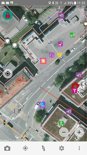
The release notes list most of the changes including preliminary documentation on the opening hours editor.
I would specifically like to thank Mateusz Konieczny and Holger Jeromin for beta testing (Mateusz particularly for finding a last minute issue).
0.9.9 took a long time to get to this state, mainly due to a lot of under the hood work which should make upcoming releases much easier. I’ll be trying to step up the release frequency again and expect 0.9.10 including C-mode to be available by the end of the next quarter.

I’ve started getting into capturing on Mapillary and have found it to be incredibly helpful for mapping on OSM. I wanted to go through my setup in case it’s interesting for others.
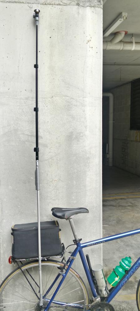
- I prefer to capture 360 images
- I use the LG360 (R105)
- I bought two LG360 cameras off ebay, $125USD and $90USD. The LG360 is on the cheaper end of the scale compared to some of the others on the market.
- Though there is a flaw in one of the cameras I bought which is a shame as you can see the left half of the image (front camera) is blurry.
Location