Diary Entries in English

Recent diary entries

Posted by Suthakaran on 12 September 2017 in English. Last updated on 13 September 2017.

I was surprised when I received an email confirmation of the scholarship to participate in the conference of SOTM 2017. It was the first time to participate in the international SOTM which was held in Aizuwakamatsu, Fukushima, Japan.

SOTM Group Photo 2017

My application of talk SOTM 2017 was selected and I got an opportunity to present the OSM in Sri Lanka in the conference which has given me the opportunity to express my country circumstances of OSM activities and Importance of the OSM activities in Sri Lanka.

See full entry

Location: Batticaloa, Manmunai North DS Division, Batticaloa District, Eastern Province, 30100, Sri Lanka
Posted by StephaneP on 11 September 2017 in English. Last updated on 2 June 2024.

RTK accuracy

Since 1 or 2 years, I’m testing some low-cost GNSS receivers with RAW output. The goal is to get a cm accuracy. One way is to store the raw data, then post-process it with the open-source software RTKLIB. I had various fails and success and I finally find a point to place my own reference station, my “base”: base

See full entry

Posted by lonvia on 10 September 2017 in English.

waymarkedtrails.org, the site to show all things route related, has always taken care to try to put route relation members in a sensible order before displaying them. A couple of weeks ago this has changed. The site now assumes that the members of each relation are already in the correct order. The reason for that is simple: sorting route relations is hard.

Before explaining why sorting is hard, let me explain why order even matters. As long as you simply want to display the route on a map, the order is not important. Simply color each way in the relation to your liking and the route is nicely visible for a human reader. However, waymarkedtrails.org does a bit more than that. It displays an elevation profile and allows to download a GPX of the route, so you can put it onto your favourite mobile device. When the route is not sorted in the expected order, then the GPX is unusable for many applications, for example in Garmin Basecamp.

So why not sort the route automatically? On first sight, this seems to be a simple task. After all, a route should be a simple linear connection from A to B. Unfortunately, the real world is much more messy.

Even the most simple case of a linear route from A to B already has two solutions to the problem. The route may go from A to B or from B to A. In most cases the direction doesn’t really matter but there are exceptions. Take a downhill mountain bike route, for example, or a nature trail with information panels that should be visited in the correct order.

Then there are loop routes which end at the point where they started. When sorting automatically there is no way to determine the starting point of the route. In both cases, we could add extra tagging to mark the start and end points. But why add the extra work when sorted route give the start and endpoints clearly at the beginning and end of the list?

See full entry

Posted by dieterdreist on 7 September 2017 in English. Last updated on 8 September 2017.

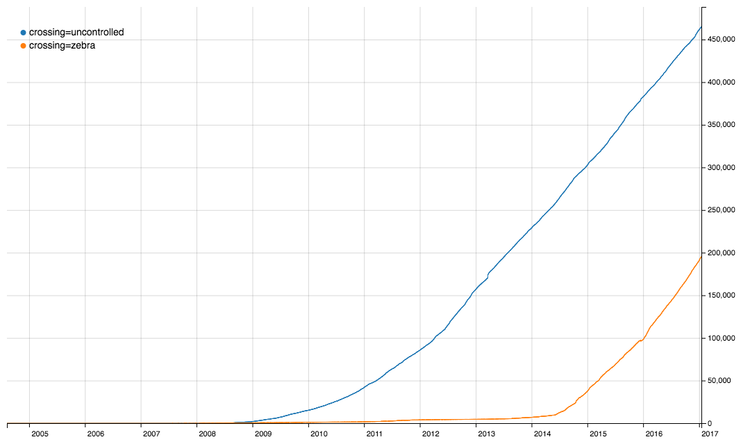
After some tagging chat on the Italian ML it came to my attention that iD is setting crossing=zebra tags on crosswalks, a tag that is not documented as value for the crossing key, besides in the UK. As I believe that using different tags for the same thing - although not really harmful - makes everyone’s lifes a bit more complicated, I thought I’d give them a hint, after all, usage of this tagging is still behind the longer standing established and documented one. So I created this issue: #4316.

It came up, there are already 3 tickets where the same issue had also been dismissed.

IMHO, we should take care that editing software proposes the same presets for the same objects and properties (not necessarily the same level of detail, or presets for the same things), because tag fragmentation is a burden on everyone. In this case it is very clear that crossing=zebra only came to significant use when it was added as a preset in iD in May 2014 (compare with the graph above).

Thanks to Kurban Bayram, I had a four-day weekend. Thanks to the preparations for the Asian Indoor and Martial Arts Games, central Ashgabat was closed to most traffic for all intents and purposes. So I stayed home and used the nascent gazetteer project to check for typographical errors and other misspellings in the OSM database for Ashgabat. I think I have caught all major typos and other errors.

I also began research into the historical names for the streets in this city, which in some cases have changed several times. To give you an idea of what’s involved, here is the entry for Magtymguly, a major thoroughfare, which is now on its fifth name:

Magtymguly Magtymguly (2033) şaýoly Mervskiy prospekt, Kuropatkinskiy prospekt, prospekt Svobody, prospekt Stalina.

Magtymguly Pyragy (1724-1807) was a Turkmen spiritual leader and philosophical poet who made significant efforts to secure independence and autonomy for his people in the 18th century. He is considered the greatest Turkmen poet, though he wrote in Arabic, Persian, and Chagatai, not in Turkmen. The original name of this street was Mervskiy prospekt as the street led eastward to the city of Merv (modern Mary). It was subsequently changed to Kuropatkinskiy prospekt to honor Russian General Aleksey Kuropatkin (1848-1925), who is credited with the victory over the Teke armies at the Battle of Gökdepe and from 1890 to 1898 was governor of the Transcaspian governate, effectively viceroy of Turkestan. He was Russia’s minister of war from 1898 to 1904, and was blamed for major Russian defeats in the Russo-Japanese War. During the Soviet period the street was named prospekt Svobody (Freedom Prospect) except for a period between 1953 and 1961 when it was renamed in honor of Iosif Stalin.

Location: Kopetdag District, Ashgabat, Turkmenistan

To name a few things in the above area:

  • residential roads tagged as motorways, primary or secondary

  • the same road went from motorway to service to residential to primary

  • island roads (not connected to rest of network)

  • roads ending just before the crossing

  • roads split in arbitrary segments all over the place

  • ways with a node for every half a metre length

And how about this?

See full entry

Location: Xã Thọ Phong, Quảng Ngãi Province, Vietnam
Posted by mingo23 on 4 September 2017 in English.

As a big OSM passionate I will always remember year 2017, as it gave me the chance to join my first State of the Map conference: SotM 2017 in Aizu-Wakamatsu, Japan, on August 18-20, 2017. I was so lucky to be selected as a scholar, something I did not expect too much when I initially applied.

Even better, my application for a talk at SotM 2017 was also successful and I had the privilege of giving the presentation titled “OSM seen from a GIS researcher: experiences & perspectives”. The purpose of this talk was to give an overview on the ongoing research trends on OSM. More in detail, I presented three applications I have worked on over the last couple of years: 1) a procedure to assess the quality of OSM road networks; 2) an analysis of OSM tagging patterns; and 3) a GIS application to convert OSM data into Land Use/Land Cover (LULC) maps. The slides are available here, while the live recording of the talk can be found here. I was really surprised that my talk has generated so much interest in the audience. I am used to take part in conferences, but I’ve never received so many photos during a talk! I hope my presentation has inspired many people :)

See full entry

Location: Cascina Rosa, Città Studi, Municipio 3, Milan, Rodano, Milan, Lombardy, 20133, Italy

A couple of weeks ago I launched an online survey aimed to collect demographic data about OSM contributors for a research project (funded by the University of Nottingham and the Engineering and Physical Sciences Research Council) concerned with gender biases in OSM. The survey has received a great response and I would like to send my thanks to all users who have so far participated.

However, more responses are needed (especially from women). I would therefore like to encourage any mappers, male and female, who have not yet participated, to consider doing so. There are only six questions and the survey takes less than a minute to complete, plus you could earn a £15 Amazon voucher for your time (apx. US$20).

The gender imbalance in OSM contributing is a recognised aspect of the project. The results of this survey will help to better understand the impact of this bias which could lead to more targeted strategies for widening participation. For more information and to complete the survey please visit:

https://nottingham.onlinesurveys.ac.uk/osm-user-profiles

Thank you.

Posted by TomaszWójcik on 2 September 2017 in English. Last updated on 3 September 2017.

Current rendering order makes some bugs or problems with displaying data.

Examples: osm.org/#map=19/52.40698/16.96147 (piece of landuse=forest missing on landuse=grass) osm.org/#map=19/52.38318/16.95716 (piece of landuse=residential area protrudes over landuse=meadow)

I took and concider all tags from landuse=* , leisure=* , natural=* and tourism=* keys, which are allowed to map as areas, and analyze them, trying to order logically as layers.

Main assumptions:

*Waters and rock/ stones above green landcovers

*Higher plants above lower plants

*Physical coverage areas above areas describing terrain usage

*Treating parks and village greens as groups of unspecified plants

Problem to solve:

An unavoidable direction which is OSM moving towards is more, and more precision. This means eg. covering an amenity=* areas by physical elements like buildings, grass or pitches. Then this cultural amenity=* or tourism=* areas becomes unvisible, and the only thing left is a label text. The same thing happens with parks overdrawn by certain types of plants, what causes loss of area park-status information, and loss of park borders information.

Examples: osm.org/way/66266360 (barely visible amenity=hospital) osm.org/#map=19/52.38752/16.94985 (amenity=kindergarden with grass pieces missing) osm.org/way/336645782 (barely visible amenity=school) osm.org/way/257507437 (barely visible leisure=park) osm.org/way/4685998 (barely visible leisure=park)

In my opinion, way_area key works good only between physical man-made landcover areas (group 5 on my list) and physical natural landcover areas (group 6). For example: small amenity=parking is rendered above large landuse=forest in the suburbs, but on the other hand, small landuse=grass pieces are rendered above larger amenity=parking area in the cities.

See full entry

Posted by Sidorela on 1 September 2017 in English. Last updated on 15 September 2017.

On 18-20 august I participated for the first time on State of the Map conference, which this year was held on Aizu-Wakamatsu Japan. One year ago I started to participate on events organized by Open Labs Albania, the only hackerspace in my country which promotes Free Open Source software and open data. They organize many events for different projects as Wikipedia, Fedora, Nextcloud, LibreOffice etc.

After a few days one of my friends Redon introduced me to OpenStreetMap, he helped me to make my fist changes on a map. And that was it, since that moment I started contributin to OpenStreetMap , firstly editing all the areas that I knew based on ground knowledge. At the beginning I may say that I was so enthusiastic that probably I might have made some mistakes as a newbie mapper that I was. Later I realised that it was important not only to contribute with data, but to try to add data with quality and try to be a good mapper.

I continued to participate on mapathons organized by members of Open Labs and after a few months I was able to co-organize with them. Despite mapping which I started with iD editor I started to search for other tools and so i found the featured desktop editor JOSM, which for me at the beginning was not so easy to use.
My first presentation ever in public was on 14-th of May at OSCAL where I had a workshop for “Editing OpenStreetMap” and also an info booth. I continued to participate on mapathons organized by members of Open Labs and after a few months even I was able to co-organize with them. Despite mapping which I started with iD editor I started to search for other tools and so found the featured desktop editor JOSM, which for me at the beginning was not so easy to use.

See full entry

Please use this URL in the custom imagery field: http://ittc.state.gov/hot/1.0.0/ashgabat-aug2017-flipped/{zoom}/{x}/{y}.png

Through MapGive, the Humanitarian Information Unit (HIU) of the U.S. Department of State is providing the OpenStreetMap community access to updated satellite imagery services to help assist with mapping for humanitarian and development programs.

Imagery Details This imagery is from Digital Globe’s WordView-3 satellite, and is made up imagery taken on August 8 and August 14, 2017. The imagery has been orthorectified for terrain corrected geographic precision. Additionally, the imagery has been contrast stretched using a custom stretch and processed into a Tiled Map Service (TMS) for performance.