Diary Entries in English

Recent diary entries

Posted by mds08011 on 21 September 2017 in English.

I am in the process of trying to update and add bus stops and bus routes in San Diego County. The majority of current bus-stops are based on old data and are many are just a single located at an intersection. MTS and SANDAG have new SHP layers and update this information quarterly. I am approaching this in pieces so as to not break any functionality of the existing bus routes in OSM. However, from what I have seen, the vast majority of bus stops need to be changed and many routes are not added yet.

http://www.sangis.org/

TRANSIT_STOPS_GTFS Publication Date: 2017-06-28 Summary: Public transit stops and stations covering the County of San Diego. Bus, commuter and light rail, and trolley stops managed by the San Diego County Metropolitan Transit System (MTS) and the North County Transit District (NCTD). Data is developed from the General Transit Feed Specification (GTFS) data available from the transitland feed registry (formerly from the GTFS Data Exchange). Layer is updated quarterly and may not reflect most current route information.

TRANSIT_ROUTES_GTFS Publication Date: 2017-06-28 Summary: Public transit routes covering the County of San Diego. Bus, commuter and light rail, and trolley routes managed by the San Diego County Metropolitan Transit System (MTS) and the North County Transit District (NCTD). Data is developed from the General Transit Feed Specification (GTFS) data available from the transit land feed registry (formerly from the GTFS Data Exchange). Layer is updated quarterly and may not reflect most current route information.

Posted by LeifRasmussen on 21 September 2017 in English.

I recently added “area roads” to downtown Durham, NC. I made the surface of the roads visible on Openstreetmap. I was wondering if their is any specific way to map road areas. I currently map them as “area = highway” and “highway = service”. Feel free to check it out!

Downtown Durham osm.org/#map=19/35.99361/-78.89968

Downtown Chapel Hill osm.org/#map=19/35.91627/-79.05645

Chapel Hill Public Library osm.org/#map=19/35.93251/-79.03549

All three links lead to a place in Openstreetmap where I mapped roads as areas.

I anyone else mapped roads as areas, please reply a link to the location!

Location: 35.997, -78.902
Posted by Minh Nguyen on 20 September 2017 in English. Last updated on 8 March 2026.

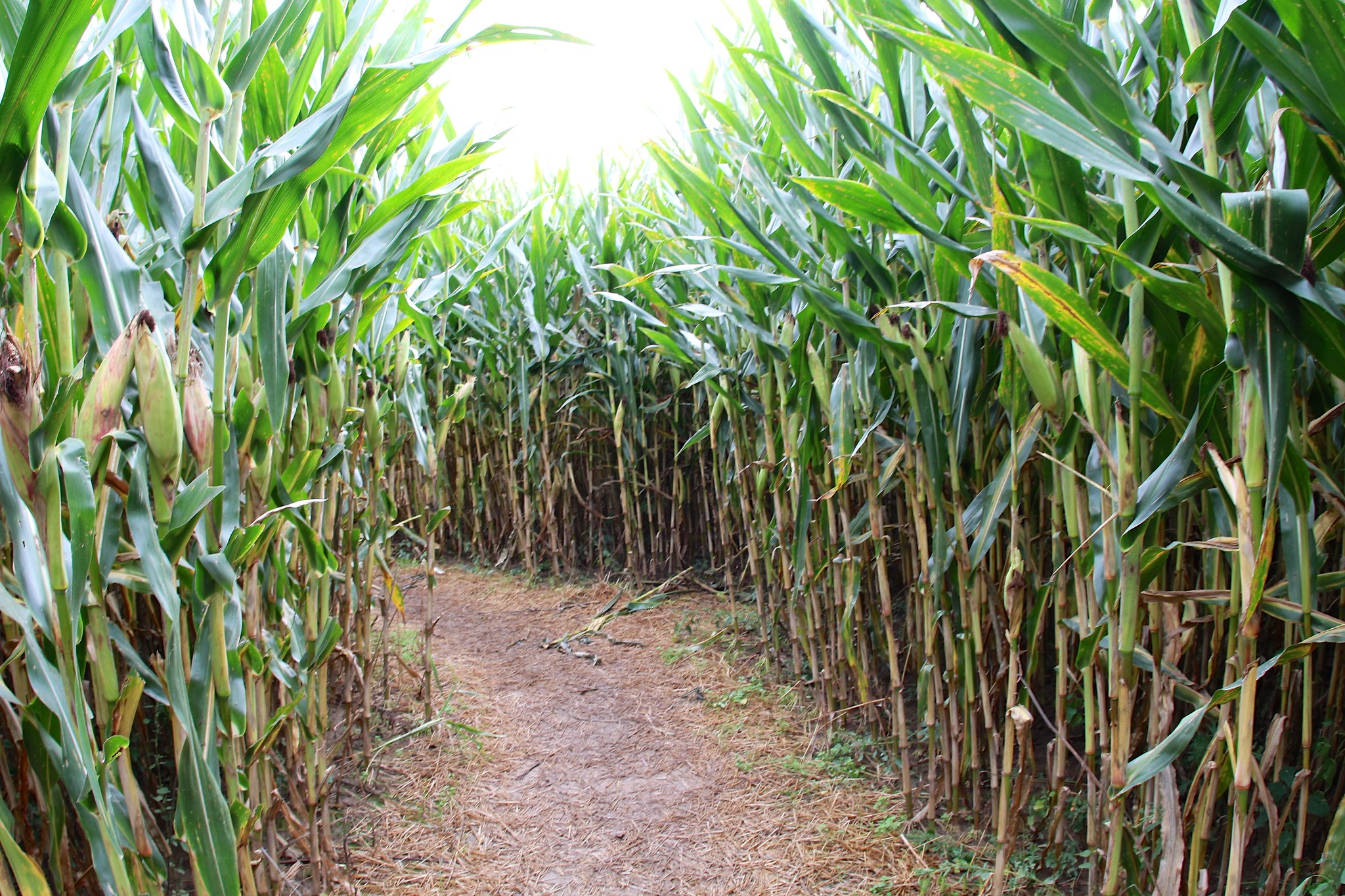
It’s corn maze season in North America: for a couple months, farms all over are inviting folks to explore mazes they’ve cut out of corn fields.

CVNP A corn maze in Northeast Ohio by David Fulmer, CC BY 2.0.

In OpenStreetMap, several corn mazes have been micromapped across Southwest Ohio. The designs change each fall, so the mazes have to be micromapped all over again.

See full entry

Location: Reily Township, Butler County, Ohio, United States
Posted by OSMF Data Working Group on 20 September 2017 in English.

The Data Working Group is conducting a survey as part of its work on a policy covering paid mapping.

When OpenStreetMap started, it was largely a project of hobbyists contributing to OSM in their spare time. They chose freely what to map and which tools to use, and they took individual responsibility for their contributions.

The continuing growth and popularity of OSM have also brought more and more organised mapping efforts, mostly in the form of companies setting up paid data teams to improve OSM data in specific regions or for specific use cases, but also unpaid groups like school classes that are directed to work on OSM.

These organised mapping efforts are an integral part of today’s OSM contribution landscape and, when done well, help make OSM better and more widely known.

In order to ensure good communication, and a level playing field, between individual community members and organised editing groups, the OSMF Data Working Group has been tasked with developing guidelines for organised groups. These guidelines will above all set out some transparency requirements for organised groups - things that are already voluntarily followed by most groups today, like informing the mapping community about which accounts edit for the team.

We have prepared the following survey with a few questions about such a policy to give us a better understanding of what the mapping community expects from such a policy. The survey is aimed at everyone editing (or planning to edit) in OSM, whether as individual mappers or as part of a team, and your answers will help us in fleshing out a draft policy.

See full entry

Posted by ramyaragupathy on 19 September 2017 in English.

Quite excited to be at the SOTM Asia 2017 Conference in Kathamandu this weekend. This year I’ll be talking about my OpenStreetMap readiness assessment work and walk through on how the approach varies from prior art, opening new avenues for mappers to explore data coverage.

I’m also collaborating with Jennings Anderson on his contributor metrics analysis & trying to understand how does mapping community health reflects on the readiness work.

If you’re at Kathmandu this weekend, do catch me up for more conversation over a Chiya! 👋

We recently rolled out 8.2 million km² of high-resolution satellite imagery from DigitalGlobe to our base map. Read more about it here → https://blog.mapbox.com/updating-8-2-million-km%C2%B2-of-high-resolution-satellite-imagery-b68070bdf4b2

All this imagery is available to be used by OpenStreetMap contributors for mapping! 🎉

Here is a breakout of the extents:

Asia Major cities and urban corridors in Middle East, India, China, Turkey, Vietnam, Thailand, Malaysia, South Korea, Indonesia, and the Philippines.

Africa Egypt and parts of Kenya.

Europe Major cities in Poland, Ukraine, Romania, Iceland, and Hungary. Also Paris and Moscow.

South America Major parts of Brazil, Paraguay, Uruguay, Argentina, and Chile.

North America Large parts of Mexico, Cuba, and Central America, along with southern cities of Canada.

This imagery will enable mappers to trace intricate details like buildings intrusions, turn lanes, trees and so much more! Happy mapping! 🌐

Rio de Janeiro Rio de generio

See full entry

Posted by mvexel on 18 September 2017 in English. Last updated on 19 September 2017.

A few years ago I started a bi-weekly video chat for US mappers, called Mappy Hours. They were fun and varied, with topics ranging from tagging discussions to a presentation about OpenHistoricalMap and many things in between.

Then we all got busy and the Mappy Hours stopped. I was recently reminded about them on the OSM Slack channel, and I thought it would be nice to restart them. So here are the details of the first Mappy Hour:

Wednesday September 27 at 5:30pm Pacific Time

We used to use Google Hangouts, but there were problems with that: a limited number of video participants, you couldn’t call in, plugins.. There is no perfect solution but I have had success with Zoom so we will try that. You can either download the Zoom client or call in using your phone.

Zoom link

There are local dial in phone numbers for many countries.

The topic for the first Mappy Hour will be State of the Map US. What are you looking forward to? Do you have a presentation you want to promote? Do you have ideas to make the conference even better than previous years? Let’s talk! Even if you are not planning to attend SOTM US, I invite you to attend: there will be plenty of time to talk about other things as well.

Posted by pnorman on 17 September 2017 in English.

Dear all,

Today, v4.3.0 of the openstreetmap-carto stylesheet (the default stylesheet on openstreetmap.org) has been released.

Changes include

  • Moving ford and emergency phone to a new tagging scheme
  • Moving natural=tree to higher zoom level (z18+)
  • Changing embassy color to brown
  • Rendering name for waterway=dock
  • The same line wrap of amenities for all zoom levels
  • Fixing combined railway/highway ordering regression
  • Fixing line wrapping bug in Docker
  • Some documentation and code cleaning
  • Improve ferry line text legibility
  • Hide small theme parks and zoos
  • Use solid lines for admin borders at low zooms

Thanks to all the contributors for this release, including stevenLAD, a new contributor.

For a full list of commits, see https://github.com/gravitystorm/openstreetmap-carto/compare/v4.2.0…v4.3.0

As always, we welcome any bug reports at https://github.com/gravitystorm/openstreetmap-carto/issues

Posted by AnisKoutsi on 17 September 2017 in English. Last updated on 18 September 2017.

This post was aggregated form my personal blog ( http://anisakuci.com/2017/09/04/state-of-the-map-2017-it-was-a-blast/ )

My first introduction to OpenStreetMap was almost a year ago, when Redon Skikuli, a fellow friend from Open Labs Hackerspace presented me this great project, which I really liked since the beginning.

I started contributing at OpenStreetMap, editing the map using ID editor in the beginning , adding information to the map, co-organizing small mapathons and events at the local hackerspace that I am part of, and telling people I know, advantages of using OSM. As time passed by, I found out, that State of The Map, which is the annual gathering of OpenStreetMap enthusiasts from all around the world, would happen within a few months, in Aizuwakamatsu, Japan.

I applied with a presentation, and a few weeks later I received the confirmation email from Rob Nickerson. I was thrilled to find out that I was one of the chosen scholars by OSM Foundation to attend the conference, and that was a great opportunity to meet contributors from other countries and communities and go deeper into the OSM ideology.

Months passed by, after struggling to get the visa, with the huge help of Dorothea Kazazi, I finally made it.

The moment has come to attend SoTM for the first time !!

Long trip to arrive in amazing Aizuwakamatsu, but the excitement to be there was way more intense.

The conference started. After registering and receiving some swag and goodies provided by the organizing team and a delicious Japanese tea, time to start the sessions. I held my presentation “How to start an OSM Community” during the first day of the event, in the main hall. I explained how the OSM Community in my country was created and how it grew up, I shared my thoughts about essentials that are needed to have a healthy community, gave some tips on how to encourage new people to join OSM and how to create communities based on a country’s historical and cultural background.

See full entry

Posted by silver mapper on 17 September 2017 in English.

Travelled to Madeira for a week at the end of February, staying at the excellent Pestana Grand Ocean Resort hotel. I have been prompted to compile this diary entry more than six months later because of lonvia’s user diary entry of 10th September, regarding https://waymarkedtrails.org/, and my particular interest, https://hiking.waymarkedtrails.org. First, though, I must comment on the excellent level of detail in OSM for Madeira; I was extremely surprised, but so pleased, too, of course. It was of help in all ways: our journeys, our walks, and restaurants, even. What a difference it makes! We undertook three walks during our stay: the first, to get our legs moving, from the hotel, directly on the seafront, to Cãmara de Lobos alongside the beach. The second was to take no. 81 bus from Funchal to Eira do Serrado, then walk to Curral das Freiras (Nun’s Valley). What a scenic walk! The third was to take no.96 bus to Estreito de Cãmara de Lobos, then walk Levada do Norte (South) to Cabo Girão. We had hoped to walk from Monte to the botanic gardens, also, but there had been a landslip, unfortunately, and the way was closed. Second, lonvia’s waymarked trails were excellent in highlighting and naming the officially recognised walks: Madeira is such a complex arrangement of hills that it would be difficult to choose routes otherwise. Together, and continuing to use my same resources on my ‘phone, they contributed to a most enjoyable holiday. Finally, I recollect the usefulness of the waymarked trails as I walked sections of the Chiltern Way and created some of its child relations in JOSM.

Location: Ajuda, São Martinho, Funchal, Madeira, 9000-749, Portugal
Posted by Polyglot on 17 September 2017 in English.

Giacomo Servadei continued to work on the PT_Assistant plugin for JOSM

Hiking, bicycle and equestrian routes

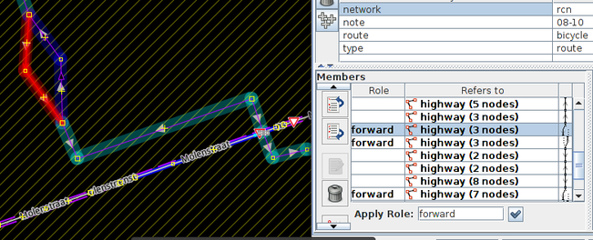
The plugin is not just about public transport anymore, it can also highlight hiking and bicycle routes and report problems with their continuity. It now also visualizes forward/backward roles, which makes editing them a lot more convenient.

One of the problems I noticed over the past year, was that while fixing public transport route relations, sometimes foot and bicycle routes were broken and the validator didn’t warn about this. The other problem is that when bicycle routes fork, forward and backward roles are needed, but they depend on the direction of the way and those little arrows are very hard to see.

Now one leg is coloured in blue, the other in red, which makes it immediately obvious whether the route is mapped correctly and it’s easier to know if forward needs to become backward or vice versa.

forked bicycle route relation

Public transport improvements

## Tools

See full entry

Posted by SimonPoole on 17 September 2017 in English. Last updated on 22 September 2017.

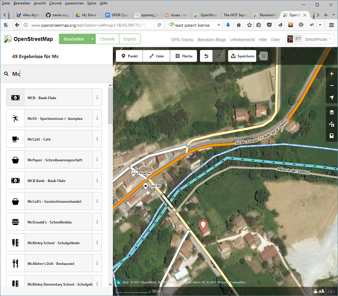
A couple of weeks back I regenerated the data in the “Name Suggestion Index” from a current planet dump, adding a largish number of new entries. The index is used by iD and Vespucci to generate canonical spellings for well-known brands and to apply the correct presets at the same time.

Naturally the raw list contains a lot of nonsense, and that’s why there are two ways to reduce noise to an acceptable level: one, a list of (mis)spellings that are mapped to a canonical value https://github.com/osmlab/name-suggestion-index/blob/master/canonical.json and, two, a filter https://github.com/osmlab/name-suggestion-index/blob/master/filter.json that removes names that we don’t want, for example Bank for banks.

See full entry

Posted by -karlos- on 15 September 2017 in English.

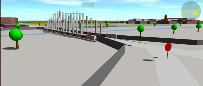
A bridge, rendered by OSM building parts

As I wrote last time, “OMS go” will only be used for experiments now. Recently my friend Martin told me about an optimisation, he had done successfully. I implemented it and you may feel remarkable increased control reactions. This is really good if you use the head tracking of Google Cardboard or other stereo devices. To get the best performance, you may need to restart your browser. The 3D interface WebGL is limited and my data handling code is a hack anyway. My new tile handling does have disadvantages: Od shadows ad sunny places. And you can’t select things any more! You may add “&opt=0” to your URL to switch back to the old mode. or switch of shadows by &sha=0

What I did, may only be interesting for codes of 3D renderer:

See full entry

Posted by Polyglot on 13 September 2017 in English.

Bogdans Afonins made several improvements to JOSM’s search and to the download dialog:

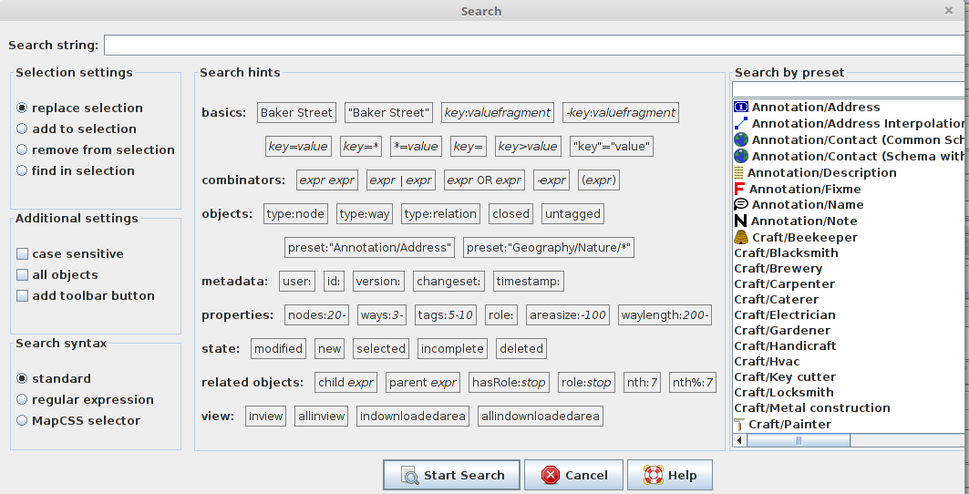
Search dialog

JOSM search dialog now includes search based on presets

Search is incredibly powerful in JOSM. It’s possible to add buttons to the toolbar for searches you need over and over again. Some examples:

Select all ways of a roundabout or a closed oneway way, which is in view plus all the nodes of that roundabout that have more than 1 one way connecting to it:

R inview ((junction=roundabout OR closed  oneway=yes) OR ways:2- child (junction=roundabout OR closed oneway=yes))

I use this to make them round and distribute the nodes or to conveniently select all the ways of a roundabout after it was split.

Find all routes that are already public_transport:version=2, which have members in view and which were modified:

R "public_transport:version"=2 route=bus inview modified

Download dialog

See full entry

Posted by GOwin on 13 September 2017 in English. Last updated on 27 July 2018.

This post is a month overdue. I was in the Davao region last August (for business), but I thought I should touch bases with a few local organizations, including the local fire department, to chat about OpenStreetMap, since I’m there anyway. :smile:

My inquiries were enthusiastically received by the local fire officials as I introduced the goals of the HailHydra(nt)! initiative, and they decided they’re willing to host a mapa-thon. We set it during the city’s annual Kadayawan Festival.

Looking back, I should’ve pushed for another date. With many other departments busily attending to their own programs and tasks for the said activity, we ended up doing the mapping ourselves, instead of the expected participation of other orgs, we still managed to complete the goals we set for the day, with a little overtime :grin:

A Fire Hydrant Network base map

The main objective is to map the fire hydrants of the city, and complete the map of the fire stations and volunteer brigades operating in Davao.

See full entry

Location: 27-C Santa Ana, Poblacion District, Davao City, Davao Region, 8000, Philippines