Diary Entries in English

Recent diary entries

Posted by Richard on 4 October 2017 in English.

I’ve just added support for a couple more tags to cycle.travel’s directions and thought it worth mentioning - everyone likes seeing their mapping being used.

First up, cycle.travel now includes ‘knooppunten’ (cycle node networks) in turn-by-turn directions. These are found in the Netherlands, Belgium and parts of Germany, and help you navigate dense cycle route networks. Here’s an example: https://cycle.travel/map/journey/51597

Knooppunten example

This picks up rcn_ref= or lcn_ref= tags on nodes.

cycle.travel also includes mountain passes in the turn-by-turn directions, for people who like riding somewhere hillier: https://cycle.travel/map/journey/51600

See full entry

A quick lunchtime stroll with osmTracker in hand resulted in creating bicycle parking points on Worcester Boulevard, Christchurch, New Zealand.

The gps trace wobbled around a lot as it didn’t seem to be able to get a good fix among the tall buildings but it was accurate enough to identify the points on the LINZ aerial photos.

osm.org/user/Adam%20Heinz/traces/2514597

Adam Heinz 3 October 2017

When I moved to the United States six years ago, center turn lanes were a new thing to me. Two Way Left Turn Lanes (TWLTL) , as they are officially called, make traffic safer on busy roads where left turns are made frequently, by offering a dedicated lane for left turns:

design Source: MUTCD

When I first started to map these lanes, there was no documentation on the OpenStreetMap wiki on them, so I just started to map ways that have them with center_turn_lane=yes, thinking that I’d revisit them later if the community came up with more sensible tagging scheme.

In 2012, infamous US mapper NE2 created a page dedicated to TWCTL, adopting the British spelling centre_turn_lane=yes. There are around 6000 uses of this tag, most of them in the United States. The page was created without much if any discussion in the US community: there is only one reference to it on the talk-us mailing list[1].

See full entry

We all used building:levels and alt_name without giving it a second thought. Why are these keys built that way? Why not levels:building? To me, it looks like there is a rule for building composite keys.

Suffixes

ref is the basic tag for storing a reference number. For a reference number in some third-party table, we add a suffix: ref:third_party. That is because the new tag still contains a reference number. We have all such numbers in ref* keys. The rule of thumb is, the meaning of a value is defined by the basic tag before the suffix. ref:third_party is still a ref, and source:maxspeed is a source.

Sometimes we cannot use suffixes for historical reason. That is the case with name: we use name:en and other suffixes for names in other languages. For that reason, we build composite keys by prepending a content with an underscore: local_name or place_name. These are still names — a reversed order from the semicolon notation.

Of course, an underscore is also used for multi-word keys: public_transport and admin_level.

Namespaces

Then, there are namespaces. The most known is addr: with addr:housenumber and so on. Without a suffix, addr key has no meaning. The same with contact: and turn:. Namespaces are used for marking a group of tags that have the same meaning, have similar value formats and they are usually described on a single wiki page.

Some namespaces are used for tying properties to a part of the object described by the main tag, and for adding more specific properties of it. For example, building:* tags describe attributes of a building, and we also have roof:type and fire_hydrant:type. These words are most often put on the same object as a key or a value, e.g. building=yes or amenity=fire_hydrant, but also can mean a part of a structure denoted by these tags, like how buildings almost always have a roof.

See full entry

Posted by RobJN on 2 October 2017 in English.

…so say a minority of people.

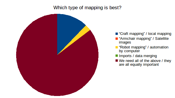
If you read the OpenStreetMap mailing lists, or follow (non-OSM) news then you’d be forgiven for thinking that we live in a world where people’s views have become incredibly narrow. But in shock news from State of the Map 2017 we discover that most people can happily live alongside their fellow mappers.

During my live-polling session at SotM, I asked the audience to participate in a series of questions via the online polling system, DirectPoll. You can watch the video and review the results in full.

But today, say hooray to the 85% who say that “We need all forms of mapping / they are all equally important”.

OSM Live Polling results

Thanks.

Posted by apm-wa on 1 October 2017 in English. Last updated on 25 May 2019.

The Asian Indoor and Martial Arts Games are over so traffic is going back to normal.

Today we (my wife, daughter and I) visited Vatutin Cemetery to collect locations of more grave monuments commemorating prominent people. The Mapillary upload is underway so I should get that done fairly soon. A number of them have streets named after them here in Ashgabat.

I have added a number of historic names of streets in downtown Ashgabat to the OSM database so that folks who use an old historical name will potentially find the entire list of names, wherever I have been able to find them. Not done yet–there are still a few mysteries!

Also, signs are now up on the 11 new retail buildings in the former Gazha neighborhood, though not one of them is open yet. I have tagged the buildings with the names as shown on the outside of the buildings, and added a few driveways and parking lots that serve them. I shot Mapillary imagery at night, capturing all the neon.

Neon-lit shop on Mollanepes köçesi in Ashgabat

Location: Köşi, Bagtyyarlyk District, Ashgabat, 744008, Turkmenistan

In the past three weeks (starting from 10th Sep) I have worked on the OSM Latest Keys list almost every day (with an average of one hour each time). In doing so, I have strictly adhered to

If using information from this page to make changes to the OSM database - please keep in mind the usual guidelines: No mechanical edits, no changes without checking validity of tags, inform the original mapper politely, don’t delete any relevant information…

and didn’t make a single change itself, but instead wrote nearly 500 changeset comments.

Of these 500 changeset comments, only half of the comments were answered and the error addressed was corrected by the original mapper. In the other half it was felt so (exact numbers I could not find unfortunately), that in turn the half corrected itself (without a reply by changeset comment to confirm), and the other half fixed by other mappers (eg mueschel , Thomas8122, mapper999, and others).

I personally hoped that the curve of historical development would be flatter. For this I then created the following graphic today, which show the last three weeks as well as the three weeks before the start of my action:

See full entry

Posted by SomeoneElse on 28 September 2017 in English.

A previous diary entry explains how I created a basic map legend for a map that I maintain that highlights various things common near me that tend not to get shown very well elsewhere - public footpaths, hiking trails, offices, that sort of thing. It struck me that a lot more things had names than almost any other map (other than OSM Bright) actually shows.

I therefore went through a process of looking to see what tags people used names with (it’s almost everything - here’s a named cattle grid), and what they used as the “naming tag” for various things (mostly “name”, obviously). The result is here:

Map legend showing named POIs

although to get a better idea of things click here and zoom around.

Posted by mvexel on 28 September 2017 in English. Last updated on 15 November 2017.

In my last diary, I announced that I would be restarting the virtual Mappy Hour for US / North America mappers. We had our first edition tonight and I enjoyed it very much.

Around 10 people participated. Kate Chapman from OpenStreetMap US joined us to talk about the upcoming State of the Map US conference, which is only four weeks away. We chatted about a variety of interesting topics: welcoming new members, how people become interested in OSM, membership of the OSM Foundation, hack weekends, how to best announce OSM events, and many more things.

The plan was to have this be a mappy ‘hour’ but we ended up spending two hours talking. We came up with a new name: Many Mappy Minutes. We decided to organize it about once a month. The next Many Mappy Minutes will be on November 15, at 5:30pm Pacific Time. Zoom worked well, so we will continue to meet on there: https://telenav.zoom.us/j/4084317935 . You can also dial in from a normal phone. I hope to talk to you then!

Posted by Mateusz Konieczny on 26 September 2017 in English. Last updated on 27 September 2017.

I invite everybody interested in

  • using data wikidata to add more data to OSM
  • fixing wikipedia tags
  • fixing wikidata tags

I would be happy to generate reports for your local area. It is possible to generate report about specific region (and I know that many people are interested primarily in fixing area they know well). Example report is at https://matkoniecz.github.io/OSM-wikipedia-tag-validator-reports/Bremen,%20Deutschland.html (full list of locations with currently available reports is at https://matkoniecz.github.io/OSM-wikipedia-tag-validator-reports/ )

Feedback is welcomed, especially from people who looked at the site and decided to not use it - what went wrong? Also feedback from people using reports would be useful.

I already added and improved how reports work based on requests. For example, I added overpass querries usable in JOSM that skip already fixed objects.

This tool is likely to be useful - it was already used to improve thousands of objects in Poland - special thanks go to wmyrda, rmikke who fixed massive amount of objects (thanks also to everybody else who used this reports).

Posted by ramyaragupathy on 26 September 2017 in English.

Great meeting everyone at Kathmandu and share my completness research. Here’s the link to the slide deck from the talk.

Like discussed, we’ve put up a front end called osm-analysis-dashaboard which combines completness research and Jennings’ contributor behaviour metrics in one place.

Would like to gather ideas and collaborate with fellow mappers on,

  • how best to build & verify gold standard at feature level and
  • build an amazing dashboard that help gain insights on completeness relation with contributor behaviour.

Do drop me a message with your suggestions/questions. Happy to talk through this!

kathmandu

I am very excited to host a JOSM workshop at the Cornell Branch of the Telluride Association, where I am currently a faculty fellow.This is the first OSM workshop I am running, so I would really appreciate the OSM community’s suggestions.

The plan is (a) to run a 2-hour workshop to familiarise the CBTA community (of ~30 students) with OSM and its editing options and (b) host a mapathon (OSM tasking manager)

The CBTA is a highly diverse, intellectually involved and socially active community of students. I look forward to teaching and learning from them.

Workshop countdown: 56 days :)

Location: Ward 4, City of Ithaca, Tompkins County, New York, 14853, United States
Posted by n42k on 25 September 2017 in English.

Google Summer of Code is over, and the 3D model repository was successfully completed, with great results: all the requirements are accounted for, and there were a few extra features implemented.

In August, many crucial features were added: model uploading, map, nightlies, administration of the models, comments and users, and finishing both documenting and implementing the API. I’ve also done lots of polishing, namely in the documentation, caching the models, layout improvements and fixed lots of issues in general, from bugs to simple color changes. The extra features that were added are model editing and revising, letting users alter the submitted models.

Screenshot of the model upload page The model uploading page, allowing users to add new models to the repository, and specify their metadata, including title, description, their coordinates (which they can pick on a Leaflet map), license and transformations.

See full entry

Posted by manoharuss on 25 September 2017 in English.

love

State of the Map 2017 attendees

State of the Map 2017 was a lively event. This was my first attendance at a State of the map conference. There was good participation from experienced community members from different parts of the world along with members from OSMF, DWG and from companies such as Mapillary, Telenav, Facebook, Apple, GeoRepublic, Grab and more.

It is wonderful to be part of this vibrant community. I have Mapbox to thank, for introducing me to OpenStreetMap and allowing me to work with passionate people for mapping, documentation and validation. I would like to use this diary post to answer some of the recurring questions on OSMCha and some notes from State of the Map 2017.

See full entry

Posted by NorthIsland on 25 September 2017 in English. Last updated on 12 February 2019.

Went along the Llangollen Canal this year and surprised that there was very little landuse on OSM. Based on memory and aerial photo, I am working my way from Llangollen to Ellesmere. Perhaps this will inspire more to visit! On the Farmland/Meadow issue, I tend to map according to ground colour. I follow those who think that Farmland is crops and Meadow is for grazing. meadow could be ploughed. If you can see worn tracks, lots of individual trees, growth variation, or steep slopes, then it’s probably meadow. Still waiting for someone to come up with a rendering for Fell….

Location: St. Martin's, Shropshire, England, United Kingdom

You can tell where someone’s from in Texas by what they call that smaller road parallel to the highway. A Dallasite may call it a service road, a San Antonian might say access road, and every other Texan will tell you it’s a frontage road, except of course Houstonians who swear by feeder. Regardless of what you call it, it’s a ubiquitous thing across the urban areas of Texas. Everyone’s driven on ‘em.

So why are they so chaotically mapped? an example of a highway in El Paso As it is right now, they’re typically mapped as highway=secondary throughout, switching to highway=primary or even highway=trunk when they’re part of a freeway exit for such a road. This happens regardless of the lack of any underlying changes to the frontage road itself. If I showed you a cropped image of a frontage road segment tagged highway=secondary and another nearby segment tagged highway=trunk, you probably wouldn’t be able to tell the difference.
See full entry

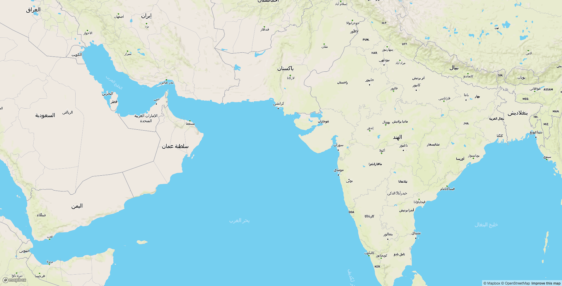
Excited to be attending and presenting at the State of the Asia - 2017 conference for the first time at Nepal. I will be talking on Sunday (24th September) about how we are building multilingual map of the world by linking OpenStreetMap with Wikidata - an amazing open data project by Wikimedia foundation. If you are interested about this, attend the talk in Banyan hall at 11:15 AM on Sunday, 24th.

Arabic map of the world. (View full screen map)

See full entry

Location: Budhanilkantha-05, Budhanilkantha Municipality, Kathmandu, Bagamati Province, Nepal