Diary Entries in English

Recent diary entries

In March 2023, I conducted a survey on women’s participation in OSM activities. It became apparent that individuals’ perspectives came into place and interpreted the survey topic differently. The survey aimed to gather perceptions, opinions, and insights into why some women do not participate in OSM activities and what factors may discourage those who were already participating from continuing. There were various reactions about the survey, from questioning the relevance of the topic to commending the effort to address it.

I was fortunate to have had support from various individuals for the topic, including Heather Leson, Arnalie Vicario, Pete Masters, Geoffrey Kateregga, and the Geochicas family, who were interested and open to exploring the topic through webinars and discussions. One such webinar featured speakers from diverse backgrounds:

  • Stellamaris Wavamunno Nakacwa, Programme Director at Youthmappers EverywhereSheMaps
  • Mikko Tamura, Community Manager at Open Mapping Hub Asia Pacific
  • Jaqueline Amorim, Expert Mapper in Geostatical Data/HOT Data Quality Intern in 2022

The webinar was moderated by Dr. Prince Kwame Odame from Africa, a lecturer at the University of Education Winneba-Ghana. You can review the webinar here.

A unique aspect of the survey was that, in addition to focusing on individuals who identify as women, I also sought perspectives from men. I was pleasantly surprised by some of their positive viewpoints, although there were also negative responses. I am grateful to everyone who took the time to participate in the survey.

One key takeaway from the survey is the importance of considering diverse perspectives. Just because something may not be perceived as an issue by one person does not mean it isn’t significant to others. We all view the world through different lenses, and it’s essential to be considerate and open-minded to learn from various angles.

See full entry

Posted by Barroszt on 13 May 2024 in English.
  1. Introduce blocks that prevent editing in selected areas, e.g. a country, an administrative unit (editing controversial objects in the field), and not the entire world. Now I can’t improve my neighborhood due to controversial editions in Ukraine.
  2. Comments on your profile should link to a page where your changeset comments are located, not to log comments.
  3. The link to your first edits in OpenStreetMap is intended to understand the difficulties for a beginner editor.
  4. Links to apps and websites related to OpenStreetMap from main page (with map) e.g.: MapRoulette, how did you contribute to OpenStreetMap?, osm-revert.
Location: Góra Buchta, Rubinkowo, Toruń, Kuyavian-Pomeranian Voivodeship, 87-120, Poland

With 2024 officially being the year of OpenStreetMap vector maps let’s do a deep-dive into vector maps: their history and how the underlying vector tiles work in detail.

img1

Vector Maps History

To understand how revolutionary vector maps were we have to go back in time to the early 2010s. One Direction is raising to international fame and raster maps are at the height of their popularity. Folks creating raster web maps rendering OpenStreetMap data into beautiful 256x256 pixel images.

But raster maps come with limitations: when you rotate the map the labels stop facing you; you can’t customize pre-rendered maps to specific use-cases on the fly; there is no fractional scaling between zoom levels. All of these problems are unthinkable nowadays: here is one example where Jochen wrote about Wikipedia struggling with pre-rendering multilingual maps for over 200 languages because they can’t change their map’s language on the fly.

See full entry

Welcome to the sixth OpenStreetMap NextGen development diary.

This week, I continued the preparation of the project for the first development release scheduled for the end of this month 🔨.

🔖 You can read my other development diaries here:
osm.org/user/NorthCrab/diary/

📖 This project is open-source and publicly available:
https://github.com/Zaczero/openstreetmap-ng

🛈 This independent initiative is not affiliated with the OpenStreetMap Foundation.

In Case You Missed It…

OpenStreetMap-NG is planned to have its first development release at the end of this month, May. After this milestone, the project will be open for new contributors! My current work focuses on delivering on that promise, finishing the core functionalities, and stabilizing the code.

Originally posted in diary #5.5.

Finishing Up the Elements Sidebar

The elements sidebar has been mostly finished. The “Part of” and “Members/Nodes” sections are now more consistent in design and have received pagination support. The orange-colored map visualization is also now working.

See full entry

Posted by bhousel on 8 May 2024 in English.

I’m excited to announce that today we released Rapid v2.3 editor for OpenStreetMap! The Rapid team has been busy working on this for the past few months - here’s 4 new features that we hope you’ll love…

🔙 Esri Wayback imagery

The world never stops changing! We added a new background layer called “Esri Wayback” to let you view historical releases of the Esri World Imagery. This background source also has a date picker to help you choose from dates likely to show changes in the current map view. Open the Background pane to try it out!

Esri Wayback

🔄 Map Rotation

Take Rapid for a spin! Now you can rotate the map to make your editing easier (and avoid straining your neck!). Rapid supports rotating with option+click-drag or shift+←/→ arrows, just like other maps you’ve used before. A new bearing control displays a north arrow, and you can click it to reset the map back to North-up.

See full entry

collaborative live mapping of regions affected by rain in Rio Grande do Sul - Brazil.

Today we are going to map the area that was affected by the rains in the state of Rio Grande do Sul, there will be a live broadcast at 7:00 pm where everyone can map and help with mapping the affected area.

task link. MAPPING OF ROADS IN THE AREA AFFECTED BY THE FLOOD OF THE PARDO RIVER IN CANDELÁRIA-RS https://tasks.hotosm.org/projects/16696

Youtube: https://www.youtube.com/watch?v=3Wm-nTnCRaQ&t=7s

organization: UFV youthmappers UMBRAOSM

live collaborative mapping in the affected areas of RS

Location: Jardim Botânico, Porto Alegre, Região Geográfica Intermediária de Porto Alegre, Rio Grande do Sul, South Region, Brazil

Greetings!

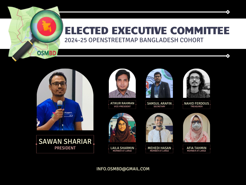
We are thrilled to share some exciting news from OpenStreetMap Bangladesh (OSMBD). For the first time ever, the OSM Bangladesh community has successfully formed an elected Executive Committee, consisting of a team of dedicated individuals who will guide our community’s activities and initiatives.

We are proud to introduce the newly elected Executive Committee:

President: S M Sawan Shariar

Vice-President: Atikur Rahman

Secretary: Samsul Arafin

Treasurer: Nahid Ferdous

Member-at-large: Mehedi Hasan Ovi

Member-at-large: Afia Tahmin Jahin

Member-at-large: Laila Sharmin Nova

Alt text

The committee is committed to upholding OSMBD’s core values of collaboration, community-driven initiatives, openness, and accessibility. Our focus is on promoting the use and development of OpenStreetMap in Bangladesh, building and maintaining a comprehensive map of Bangladesh that is freely accessible, and supporting OSM groups and initiatives through training, events, and more.

See full entry

Location: Monipuri Para, Tejgaon, Dhaka, Dhaka Metropolitan, Dhaka District, Dhaka Division, 1215, Bangladesh
Posted by Enock4seth on 6 May 2024 in English.

Hello OSM World,

Welcome to #WOSMinGhana 000

I am starting a series of OSM Diary posts title Worst of OSM in Ghana, inspired by best and worst of OSM posts I have seen. The idea is to share one photo per week (I hope I can keep up, feel free to share any you might have seen in Ghana too :D). i.e. Before and After (if I am able to improve or fix it)

Sometimes you come across very interesting mapping activities and data and you are out of words. Myself and other volunteer mappers have taken screenshots of worst contributions on OSM in Ghana over the years and then proceeded to improve them / notify mappers or organizations.

Why talk about the worst not the best? Highlighting these worst mappings might help create more awareness about what we put out there as part of individual or organized mapping activities.

This is purposely to help improve OSM data in Ghana in these areas by myself or other mappers and for us all to beware of when mapping.

Looking forward to the coming weeks.

Location: Kwameteng, Sekyere Central District, Ashanti Region, Ghana

Introduction

Humanitarian logistics is defined as the process of planning, implementing and controlling the efficient, cost-effective flow and storage of goods and materials, as well as related information, from the point of origin to the end of consumption to alleviate the suffering of vulnerable people

Its Extent and Impacts

The humanitarian logistics of peace operations in sub-Saharan Africa is one of the most challenging operations in the contemporary world. Faced with this reality, several scenarios challenge conventional logistical practices translated into humanitarian efforts on the African continent. Several events have led Africa to the current situation, whose conflicts have worsened the case in some countries. In this scenario, three countries stand out on the African continent: South Sudan (SS), the Central African Republic (CAR) and the Democratic Republic of Congo (DRC).

1.Positive Impacts

Data Collection and Mapping - GIS technology is used to collect, analyze, and visualize geospatial data. Humanitarian organizations in South Sudan leverage GIS to map various elements such as population distributions, events, infrastructure, health facilities, water sources, and more. This comprehensive mapping enables organizations to identify vulnerable areas and better understand the needs of the population.

Situation and Needs Assessment - OSM aids in conducting rapid situation assessments and needs analyses during crises and emergencies. Each region in South Sudan is prominently represented by one or the other ethnic and communal group, each with its own methods of action. By overlaying various data layers, including demographic, environmental, and public infrastructure, organizations can quickly identify areas that require immediate specialized attention and allocate resources accordingly.

See full entry

Welcome to my fifth (and a half) OpenStreetMap NextGen development diary.
Tomorrow, I’m returning home and I’ll be able to resume work at full speed 🔥.

This is a short edition of the development diary.

🐙 This project is open-source and publicly available:
https://github.com/Zaczero/openstreetmap-ng

Intro

For the past 13 days I have been on a journey of finding a new place to rent. Without my home office, I wasn’t able to become productive. The place I’m staying at doesn’t have a good office spot and being on my laptop doesn’t help. However, I am now very motivated to get back to work and push even harder!

May Will Be Big

At the end of May, OpenStreetMap-NG will include necessary functionality to run on a testing server, as well as to invite new contributors into the project. Starting with 6th of May, I won’t have any time-consuming plans for this month so I’ll do my best to wrap everything up. What’s exactly left has been described in Diary #5 Short-Term Development Plan. I have already started to prepare the All-in-One Contributor Guide which will also be finished up (it currently lacks backend/frontend-specific guides). This is going to be the first major milestone of the project!

Project Sponsors 🏅

I was happily surprised to see new faces even during my lower activity period. I will do everything to deliver the promised results. As always, thank you for supporting the project, monetarily, and with staring the project on GitHub!

Currently, the project is sponsored by 13 people!
Five private and four public donors on Liberapay, and four public on GitHub Sponsors.

Disclaimer

This project is not affiliated with the OpenStreetMap Foundation. It’s an independent and community-sponsored initiative.