Diary Entries in English

Recent diary entries

Posted by ZeLonewolf on 30 April 2024 in English. Last updated on 2 May 2024.

There is a long discussion happening in the United States section of the community forum regarding where to draw the line between the “main” populated place node values, and specifically the place=* values of city and town in New England. I thought it would be useful to do a bit of analysis to see how these values are distributed across the database when compared to population. Through this analysis, I include all tags which have place values of city, town, village, hamlet, and isolated_dwelling. I also only include nodes that have a population tag.

My overpass query for each category looks like this:

[out:csv(::id,place,population;true;"|")][timeout:60];
node[place=city][population];
out;

One of the challenges of analyzing this key is that because it represents order-of-magnitude differences, its distribution is log-normal. In other words, it forms a bell curve provided that the X-axis is drawn logarithmically.

To look at this data logarithmically, I grouped the place nodes logarithmically, in steps of 1, 2, and 5 per 10x jump. When viewing the distribution of place=town, the log-normal shape comes out quite clearly. The number on the X axis represents the upper limit of each bin.

See full entry

Posted by ivanbranco on 28 April 2024 in English.

[Semi-automated translation of the Italian diary entry]

On OpenStreetMap, a tree can be represented as a natural=tree node.

Leaf type 🌿

leaf_type is the most common tree-related tag in the database, this is because it is easily verifiable and is supported with a quest by StreetComplete. The values are broadleaved and needleleaved. Some argue that palms should not be tagged as broadleaved but with a value of their own, =palm.

Leaf cycle 🍂

This tag describes whether a tree is deciduous or evergreen. Most needleleaved tree species are evergreen, but this is not always the case, so do not infer this value automatically. You can add this value easily if you know the species, or more simply if it is autumn/winter. If not, you can try to see if satellite or street-level imagery taken at those times are available.

Genus and species 🌳

If you are not an expert, there are tools that can help you recognise the genus/species of a plant, such as Pl@ntNet and iNaturalist, both of which also exist as mobile apps. On OpenStreetMap there are many trees with species (or species:wikidata or species:xx) that do not have leaf_type or leaf_cycle. These values are of course identical for each species (and also for many genus) and can therefore be easily deduced. There are two lists on the OSM wiki that contain these values for genus and species.

MapComplete has a dedicated tree theme that can be used to enter the species while SCEE has a dedicated quest (“What is the genus or species of this tree?”).

Monumental trees 🏛️

Monumental trees can be mapped adding denotation=natural_monument. In Italy they are recorded by the Ministry of Agriculture, Food Sovereignty and Forests (Masaf) with annual updates. You can map them by adding ref:masaf, which is a unique code assigned by the ministry.

See full entry

Posted by matthewsheffield on 28 April 2024 in English. Last updated on 2 May 2026.

I’ve finished (for a second time!) mapping all the paths in my local cemetery. The first time another mapper decided that concrete or gravel ways designed for walking on weren’t “paths” and deleted them all. He also seemed to have strong feelings about people cycling in cemeteries, which is odd as The Greater Metropolitan Cemeteries Trust actually endorse it as a use of their land. As my daughter is buried in the cemetery I feel some ownership of the place, and do love it and Merlynston creek that flows through it. I’m hoping no one vandalises my work again.

Location: Hadfield, City of Merri-bek, Victoria, 3046, Australia

SotM Latam 2024 - Belém/Pará - Brasil.

The State of the Map Latam 2024 will take place in the city of Belém, Brazil, from December 6 to 8, 2024 at the Instituto Federal do Pará, this being the sixth edition of the ‘Latin American OpenStreetMap Conference’ and aiming to promote the use of OpenStreetMap (OSM), and the integration of OSM mappers, developers, open data communities, free and open source software communities, students, researchers, geoinformation professionals, non-governmental organizations, companies and public institutions.

SotM Latam 2024 After the voting period for choosing the SotM Latam 2024 logo has concluded, I am pleased to announce that the chosen option is 1.

See full entry

Location: Marco, Belém, Pará, North Region, Brazil

The eTrex 20x

Years ago when searching for a viewpoint from an old photo where I wanted to do rail photography I managed to locate the exact cliffside overlook and discovered a somewhat hidden gem of trail network in the process.

Though there is an official dirt road in the canyon below and a few desire paths offshooting from it the hills above remained relatively unmapped not showing up in the otherwise void of an area.

With the understatement of the local forecast for the afternoon/evening I packed my beloved eTrex 20x in the camera bag along with my trusty Nikon D700 planning to take in some of the views while there in between tracing runs expecting no more than some cloudiness and a light sprinkling.

See full entry

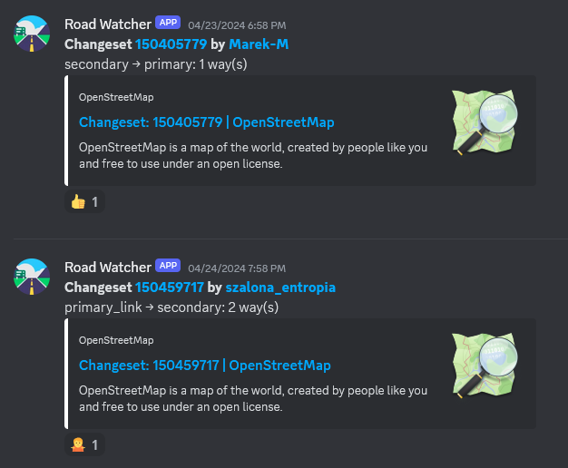
There are some object categories in OSM whose exact classification is often a matter of contention and edit wars. Main highways are one of the most prominent examples. There was a small edit war in Poland which resulted in no less than 4 blocks, but I did not let that crisis go to waste:

Behold road-watcher, a quick Python project that regurarly queries Overpass API for highway=secondary and above within a specified boundary and then detects any classification changes, sending them to a Discord channel (though it’s trivial to substitute it with another means of notification).

obraz.png

The SMCoSE YouthMappers Chapter, renowned as one of Tanzania’s largest mapping communities, hosted a transformative mapathon on April 14, 2024, at the esteemed Sokoine University of Agriculture. This event marked a pivotal moment of collaboration, extending invitations to other YouthMappers chapters in Morogoro, thus amplifying the inclusivity and impact of the initiative. Central to the mapathon’s objective was the concerted effort to contribute to Project #15530 within the HOT Tasking Manager, focusing on mapping cities across the Eastern and Southern Africa Region. By leveraging the power of open data, participants aimed to craft detailed base maps crucial for diverse applications, ranging from urban planning to efficient disaster response strategies.

Amidst an atmosphere described as “fantastic,” the event witnessed a remarkable accomplishment, the successful mapping of approximately 25,000 buildings. This feat not only underscores the collective dedication of the participants but also showcases the tangible outcomes of community-driven endeavors. Moreover, the mapathon served as a platform for new mappers to acquaint themselves with essential mapping tools such as ID Editors and JOSM, empowering them to contribute meaningfully to the OpenStreetMap ecosystem.

Special recognition is duly owed to the Open Mapping Hub Eastern and Southern Africa (OMHESA) for their unwavering support, notably through the prestigious Spatial People Award. This acknowledgment not only highlights the significance of collaborative partnerships but also accentuates the pivotal role of organizations in facilitating impactful mapathons and community initiatives. In essence, the event epitomized the ethos of collaboration, learning, and contribution inherent within the mapping community, further advancing the cause of open data dissemination and spatial awareness in the region.

See full entry

Location: Mazimbu Darajani, Morogoro Municipal, Morogoro Region, Coastal Zone, 67000, Tanzania

Theatro da Paz, Belém/Pará - Brasil

O Theatro da Paz foi fundado em 15 de fevereiro de 1878, durante o período áureo do Ciclo da Borracha, quando ocorreu um grande crescimento econômico na região amazônica. Belém foi considerada “A Capital da Borracha”. Mas, apesar desse progresso a cidade ainda não possuía um teatro de grande porte, capaz de receber espetáculos do gênero lírico. https://www.theatrodapaz.com.br/

Credito da Foto; Wikipedia, https://pt.wikipedia.org/wiki/Wikip%C3%A9dia:Wiki_Loves_Par%C3%A1#/media/Ficheiro:Teatro_da_Paz_3.jpg Theatro da Paz, Belém/Pará - Brasil

See full entry

Location: Campina, Belém, Pará, North Region, Brazil

I am currently on a visit to Ireland 🇮🇪 and a lack of proper office space makes it difficult to stay productive. I will try to prepare something cool to show off this week. Sorry for keeping you waiting!

🍟

Location: Murphystown, Leopardstown Rise, Glencullen Electoral Division, Sandyford, Dún Laoghaire-Rathdown, County Dublin, Leinster, D18 CV48, Ireland
Posted by mpulve on 22 April 2024 in English. Last updated on 25 April 2024.

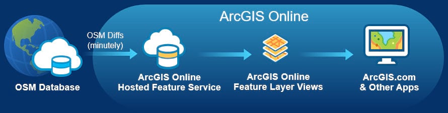
Why is OpenStreetMap ID not updated like OpenStreetMap ArcGIS? These are two different datasets that need to be linked/updated! Is ArcGIS taking over for OpenStreetMap and requiring a fee? ArcGIS needs to update OpenStreetMap ID if they participate! OpenStreetMap ArcGIS has not updated dataset in months! Please help with coordinating these two data set updates! Otherwise this in-browser edition will soon be obsolete! Use ArcGIS to compare your area with the link listed: ArcGIS OSM Are there any differences? Can anyone explain why? On the ArcGIS OSM there are more buildings that they imported from datasets. They should have updated the OSM ID data sets to match their information. Now there is a ArcGIS OSM version 2 that appears to be replacing ID OSM… ESRI

Location: 33.031, -111.379

Introduction

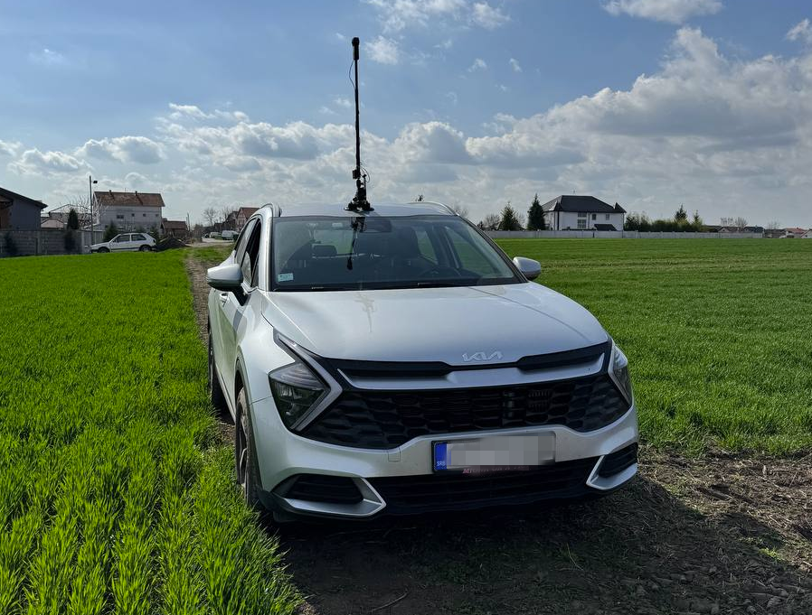
Car in action with Insta360 ONE

In this post, I will try to explain my process how to get best out of Insta360 ONE RS 1-inch camera and successfully upload images to Mapillary. It started out of my frustration of dealing with this camera and Mapillary and I hope you will not have to go through what I have been🙂. I will be focusing here more on software side (how to deal with data) rather than on hardware side (how to set up rig for image capture).

Let me first start with disclaimer that this is not easiest camera to work with Mapillary (hence this guide) and that not even Mapillary is recommending it. It definitively captures better images than GoPro 360, but everything with GoPro is more smooth over whole process, so be aware of this. Camera needs to record in video mode and it relies on additional GPS dongle you have to buy.

See full entry

We created a F-Droid repository for all Agroecology Map applications.

F-Droid is an open source app store and software repository for Android.

Agroecology Map is a Free Software, based on OpenStreetMap, citizen science platform that aims to assist in mapping and exchanging experiences in Agroecology.

  • How to add the Agroecology Map F-Droid repository?
  1. Settings
  2. Repositories
  3. Add (+) Repository (https://fdroid.agroecologymap.org/repo/)
  4. Scan QR Code or Enter repository URL manually

Step-by-step https://youtube.com/shorts/4Cw3jPzmS2I?si=zYxrgR1fHMfHEDq7

Posted by clay_c on 17 April 2024 in English. Last updated on 16 November 2025.

Pipelines are notoriously tough to map. They lie mostly underground, often with little to no visible trace on aerial imagery. What may look like a pipeline route on the ground may actually be a tangled bundle of pipelines, and even if we can figure out an individual pipeline’s true route, imagery tells us nothing about its name, who operates it, or what substance it carries.

Fortunately, the Pipeline and Hazardous Materials Safety Administration (PHMSA), an agency of the U.S. Department of Transportation, publishes authoritative, open data on pipeline routes. The NPMS Public Viewer, however, presents this data as raster images and limits how far you can zoom in. Despite this, we can use it quite effectively to identify pipelines and trace their precise routes.

Workflow

Requirements: JOSM, with Expert Mode enabled (this can be found at the bottom of the View menu).

image

Choose a county

See full entry

English below / Português abaixo


Dans mon précédent post, mon propos visait à promouvoir la cartographie de terrain comme première activité concrète de cartographie OSM proposée à des débutants, plutôt que l’hégémonique cartographie des bâtiments, mais pas du tout à dénigrer la cartographie des bâtiments en tant que telle : alors que certaines personnes dans la communauté voient essentiellement OSM comme une base de données de navigation et jugent les bâtiments comme un objet secondaire voire assez inutile, pour ma part, je reconnais tout à fait leur importance pour divers aspects, comme par exemple, participer à représenter (notamment avec les barrières et les arbres) ce qu’on appelle en géographie le tissu urbain, ou servir comme approximation de l’effectif d’une population. J’ai d’ailleurs enseigné pendant quelques années InaSAFE pour QGIS, qui utilise notamment les bâtiments OSM comme données de vulnérabilités, ou coordonné la cartographie de tous les bâtiments dans les préfectures et sous-préfectures de la RCA pendant la crise de 2012 -2014.

Pour autant, je ne fais pas des bâtiments l’alpha et l’oméga de la carto OSM, et en fait, surtout pas l’alpha. En effet, ce n’est pas le premier objet que je ferais cartographier sur imagerie par des débutants :

See full entry

Posted by GOwin on 17 April 2024 in English. Last updated on 20 April 2024.
image
It’s summer in the Philippines, and even at 08h, the sun’s already ablaze, and a friend with an umbrella is always welcome sight.

Our Tuesday morning in Tagbilaran started with a field mapping exercise with volunteers from the University of Bohol YouthMappers Club, gathering by the bandstand in Plaza Rizal for last minute rejoinders.

See full entry

Location: Poblacion 3, Tagbilaran, Bohol, Central Visayas, 6390, Philippines

Welcome to my fifth OpenStreetMap NextGen development diary.
This week has been mostly focused on GPS Traces 🛰.

🔖 You can read my other development diaries here:
osm.org/user/NorthCrab/diary/

🐙 This project is open-source and publicly available:
https://github.com/Zaczero/openstreetmap-ng

GPS Traces Demo

It’s best to experience the refreshed traces in a video form, so I prepared a short demo (no audio):
⏯️ https://files.monicz.dev/osm/traces-demo.mp4

For comparison, here’s how the same trace looks on the current website:
osm.org/user/bielebog/traces/11326871

You will quickly notice the super-fast upload speed and the new trace animations. If there’s something wrong with the file you attached, you will receive instant feedback on the upload page. One new feature is possibility to edit trace name. Previously, this feature has been hidden behind API 0.6.

One more planned feature is rendering the map behind the trace animation. Now that the system works on individual coordinates, it will be fairly easy to implement. Traces without a human-understandable point of reference are not as useful as they could be.

Unified Traces URLs

Let’s start with discussing the current URL routes.

  • If you want to access a way, you visit /way/<ID>
  • If you want to access a note, you visit /note/<ID>
  • If you want to access a trace, you visit /user/<USER>/traces/<ID>

Which is not consistent. OpenStreetMap-NG unifies this experience by introducing a new URL route: /trace/<ID>. All existing URLs remain backwards compatible and are automatically redirected.

Short-Term Development Plan

There’s just a few things left before reaching the core feature parity with the existing website. Those are the things I want to finish before inviting new contributors ツ.

  • Elements sidebar (50% work in progress)
  • User Diaries
  • User Profiles
  • Applications (OAuth) settings

Contributor Benefits

See full entry

Posted by richlv on 13 April 2024 in English.

Having both GoPro Hero11 and Max360, I was curious whether there would be any use from running both cameras at the same time. While Max 360 captures all around, would Hero 11 possibly have better resolution, which could be useful for streetview platforms like Mapillary and Panoramax, thus also providing additional detail for OSM mapping?

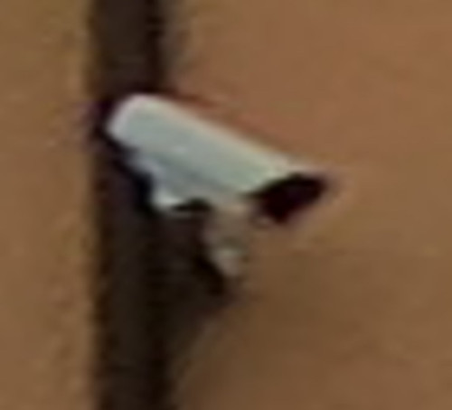
Here’s the same object - a surveillance camera - from both action cameras. Hero11 is even a little bit further away.

Max360: Max360

See full entry

Posted by tbibby on 13 April 2024 in English.

My first diary entry in thirteen years, and so much has changed on OSM. The editing tools have come on so much, and there is now an incredible level of detail, even in the rural town I’m living in now. I think I need to go back to the documentation to refresh my memory and look at adding all the things missing in my neighbourhood.

Location: Nenagh North, Nenagh West Urban, The Municipal District of Nenagh, County Tipperary, Munster, Ireland