 OpenStreetMap

never did map that much of Hahei, and don’t plan to continue, but have been mapping Broomfield, Colorado on and off for a few months now, which i do plan to actually continue this time.
Diary Entries in English
Recent diary entries
Posted by umbraosmbr on 24 May 2024 in English.
Last updated on 26 May 2024.

CNEFE: IBGE anticipates address registration microdata to assist managers in Rio Grande do Sul

CNEFE: IBGE anticipates address registration microdata to assist managers in Rio Grande do Sul The IBGE released, this Tuesday (21), in advance, the microdata from the National Register of Addresses for Statistical Purposes (CNEFE). The measure is another effort by the Institute to make available, as quickly as possible, information that can help with the calamity situation faced by Rio Grande do Sul. Full disclosure will be on June 14th.

The NCST, in it’s current configuration, extends from a quasi center point of Wilcox Junction east to Trenton FL, west to Cross City FL, and south to Chiefland FL. All three of those terminal points have expansion plans when funding becomes available: Trenton east to Newberry FL (which connects it to Gainesville), Cross City northwest to Perry FL (and then probably on to Madison), Chiefland southeast to Dunellon FL (and the various trails currently operating in/around Citrus county).
While the trail itself is documented and mapped, there are many undocumented access points. Those access points lead to local small streets, residences, and often to local businesses. I am attempting to document those access points, so that bike riders (such as myself) can find safer ways to travel to those businesses.
The Florida Department of Transportation is working on road upgrades in my local area. Those upgrades (State Road 26 and US Highway 19/98) will include paved shoulders outside the travel lane marker line. Those shoulders allow for use by vehicles with breakdowns and for bicycles (although such use should be considered carefully in light of the speed of vehicles on the highway).

Maps are invaluable tools that serve a multitude of purposes across various aspects of life. At their core, maps provide spatial context, allowing individuals and organizations to understand the geography of an area and make informed decisions. They are crucial for navigation, helping people and goods move efficiently from one place to another by providing clear and precise routes. This is vital not only for everyday travel but also for logistics and supply chain management, where accurate mapping can significantly reduce costs and improve delivery times.
Beyond navigation, maps are essential for planning and development. Urban planners, architects, and engineers rely on maps to design cities, infrastructure, and buildings. They help identify the best locations for new developments, assess the environmental impact of projects, and plan for future growth in a sustainable manner. Maps also play a crucial role in public health by identifying disease hotspots, tracking the spread of epidemics, and planning healthcare services. In agriculture, maps are used to monitor crop health, manage resources, and improve yields through precision farming techniques.
Maps are also powerful tools for communication and education. They can convey complex information in a visual and easily understandable format, making them invaluable for teaching geography, history, and science. Maps help in visualizing data trends, such as population growth, economic activity, and environmental changes, enabling policymakers and researchers to analyze and address various issues effectively. Furthermore, maps promote transparency and accountability in governance by providing citizens with accessible information about their communities and the broader world. Overall, the value of a map extends far beyond its basic function of showing locations; it is a fundamental resource for decision-making, planning, and understanding our world.
But, What If You Don’t Have Access To A Map?
Posted by umbraosmbr on 23 May 2024 in English.
Downloads
https://umbraosm.com.br/dowloads-gis-banco-de-dados-de-link-da-umbraosm/
Os dados disponibilizados pelo Instituto AddressForAll podem ser baixados por município (dados locais) ou ao nível nacional.
Listagem dos arquivos referenciados em arquivos de configuração make_conf.yaml, ordenada por jurisdição. A cada item são oferecidos os links de download (pelo hash) e de navegação pelos metadados.
| Países disponíveis: Bolivia | Brazil | Chile | Colombia | Ecuador | Mexico | Peru | Paraguay | Suriname | Uruguay | Venezuela |
https://www.addressforall.org/pt/downloads/
https://umbraosm.com.br/dowloads-gis-banco-de-dados-de-link-da-umbraosm/
UMBRAOSM www.umbraosm.com.br
Free Urban Mobility Courses in Portuguese!

1.Desenvolvimento Orientado ao Transporte Sustentável (DOTS)
2.Mobilidade a Pé
3.Mobilidade por Bicicleta
4.Transporte Público
5.Gestão da Mobilidade
link to sign up for the course for free! https://mobilicampus.org.br/cursos/
Post published by Umbraosm, the union of Brazilian mappers from Openstreetmap on their Blog. https://umbraosm.com.br/2024/05/23/1434/
UMBRAOSM www.umbraosm.com.br
Posted by umbraosmbr on 23 May 2024 in English.
Collaborative Mapping Workshop for Openstreetmap Beginners with ID Editor


Welcome to the eighth OpenStreetMap NextGen development diary.
This time the diary is one day early due to how much progress has been made.
There is more than enough for me to prepare a showcase 🏋.
🔖 You can read my other development diaries here:
osm.org/user/NorthCrab/diary/
⭐ This project is open-source and publicly available:
https://github.com/Zaczero/openstreetmap-ng
🛈 This initiative is not affiliated with the OpenStreetMap Foundation.
Notes UI Gets a Fresh Look
The most noticeable change this week is a refreshed user interface for notes. It’s now more in line with how changeset discussions look, making the whole platform feel smoother and easier to navigate. Future work will include a discussion pagination support.
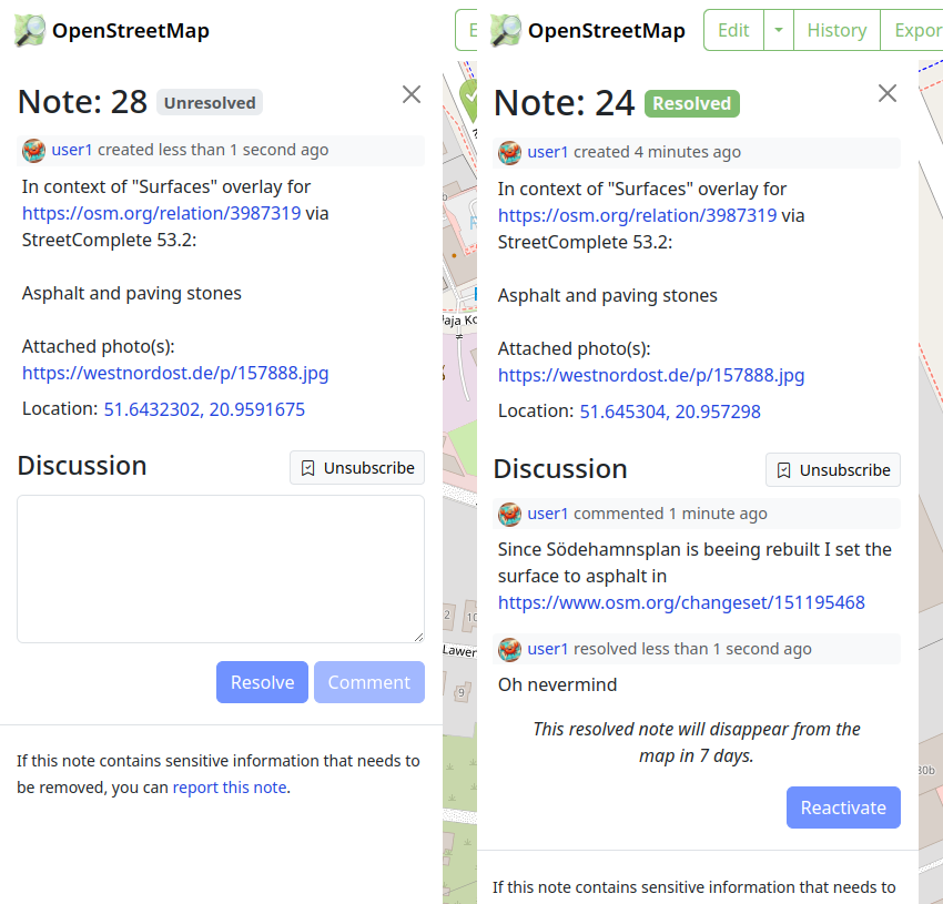
And here’s how it looks for those who aren’t registered:
Posted by pedrito1414 on 22 May 2024 in English.

At HOT, we are working on a collaboration with communities in informal settlements in Sierra Leone as part of the Know Your City project led by Slum Dwellers International.
The remote mapping of the settlements is hard, even with the excellent drone imagery flown by OpenStreetMap Sierra Leone. The environment is really dense, roofs overlap at different heights and structures that look like one from the sky actually include multiple buildings.
However, we have found the use of 3d and 2d imagery renders in parallel to be a bit of a game changer for this mapping activity. The mesh produced from the drone images allows us to angle and tilt in a way that we can better see how roofs interact with each other, what height they are and even sometimes how buildings are divided inside. We think this has vastly improved the accuracy of what we are able to do remotely.

Posted by JosephLaCatter on 21 May 2024 in English.

Thank you to those who are currently mapping or have mapped Sweetwater Texas in these few days it means a lot to me I honestly thought no one was going to help me and I would be left alone to struggle but y’all have proved me wrong and I wanted to thank you all and a special thanks to Tex2002ans for doing a lot of the work keep up the good work man!
anyways if you’re interested in joining the help the link is here. osm.org/#map=14/32.4696/-100.4006
Posted by tasauf1980 on 19 May 2024 in English.

The Bangladesh Open Innovation Lab (BOIL) and OpenStreetMap Bangladesh (OSMBD) are teaming up to host the “State of the Map Bangladesh (SotMBD) ‘2024” conference, a first of its kind in Bangladesh, a national gathering focused on mapping and geospatial technology. It aims to gather all significant stakeholders, including IM professionals, NGOs, government counterparts, industry leaders, academic experts, and geospatial enthusiasts from across the nation and the globe. This inaugural event aligns with the broader “State of the Map (SoTM)” event series facilitated by the OpenStreetMap Foundation and the global OpenStreetMap Community, reflecting a global effort to enhance open mapping initiatives. Additionally, SotMBD will be integrated into the Humanitarian OpenStreetMap Team’s (HOT) Opensummit program, emphasizing its role in fostering collaboration and sharing knowledge in the geospatial community.
Set against the breathtaking backdrop of Cox’s Bazar, the longest natural sandy sea beach in the world, the extraordinary event is set to unfold that promises to captivate and inspire. Scheduled for September 28th and 29th, 2024, this unique gathering aims to unite a diverse array of participants for a celebration of community and cooperation. The tranquil and scenic beach view will be an ideal location for an event aimed at promoting connections and creating enduring memories. Cox’s Bazar, known for its breathtaking views and lively local culture, not only serves as a location but also provides an engaging experience that enhances the atmosphere and appeal of the event. The organizers are carefully curating a program that will not only leverage the scenic beauty of the area but also underscore a commitment to inclusivity and engagement. Whether you are a local resident or a visitor from afar, this event promises an enriching experience that showcases the best of what Cox’s Bazar and Bangladesh have to offer.

We participated in the OSPP hosted by the Chinese Academy of Sciences, which stands for Open Source Promotion Plan. It is held during the summer every year and encourages students of all grades to contribute to open source projects from July to September. This is very similar to GSoC.
Introduction
OpenStreetMap is a map project initiated in 2004 by Steve Coast of the UK, based on the principle of knowledge openness. Its data model enables mappers to represent and abstract complex real-world structures by utilizing three abstract elements types, for instance, public transportation. Since 2016, the OSM Community has submitted projects related to public transport to GSOC annually. The main work is focused on a JOSM plugin called PT Assistant.
Currently, the project we initiated aims to develop a cross-platform editor utilizing a modern front-end technology stack, which is easy to use with clear interactions.
Why do we need this project?
When editing public transportation relations using iD or JOSM, you may often spend a lot of time on tasks such as selecting each segment from the starting point to the endpoint. You might be surprised to find that even at an intersection where you want to turn, the continuous straight line has not been broken for your selection.
We hope to reduce such energy consumption thing for mapper when editing public transportation by automatically calculating possible bus routes through short-distance navigation after mappers specify the stations along the way. The mapper can then fine-tune it so that it conforms to the actual route taken by buses.
At the same time, we also hope to save time in certain situations, such as when creating a group of bus stops with identical names. There is no need for manual maintenance of multiple bus stop signs composed of relations; they will be automatically matched for you. Or when moving a station sign, parking spots are moved automatically.
Posted by Enock4seth on 19 May 2024 in English.

Hello OSM World,
This is the first post in the Worst of OSM in Ghana series. I start with improving landuse=residential in Kumasi.
About 3 years ago someone mapping for an institution decided to randomly map a ton of residential landuse areas across Ghana. Some local contributors had lengthy message exchanges with them before they stopped to map.
Why? Because these landuse areas are either connected to some building or highway, etc…
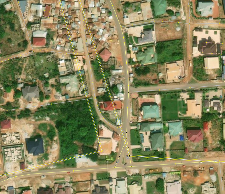 © OpenStreetMap Contributors. Screenshot from JOSM with Bing
Fast forward 2024, many of these ways still exist in OSM and interferes with new contributions. Kumasi was selected as the start of trying to reuse/delete/improve these landuse=residential because Sammyhawkrad have really put a lot of time into improving data coverage in Kumasi but these landuse=residential definitely throws him away.
In summary this is how I improved the data:
Posted by JosephLaCatter on 18 May 2024 in English.
sorry if my grammar sucks and all that I never had a good grasp on it in life. It’s been a few days since I started modeling Sweetwater so it can show up on Pokémon go when it updates their map though I’ve been aware that they might use specific versions but never hurts to model the town still, but the only issue is that no one in my town uses OSM anymore meaning I am completely alone.. a few days ago, I tried getting help which did work but not in the way I expected but hey better than nothing well all I wanted was help with buildings and all of that due to the town of Sweetwater Texas being hardly mapped (buildings wise). I tried requesting help though the notes, but it got resolved but the person gave me a website to help making it a bit faster but also giving me somewhat outdated building data.
if you’re interested in this whole thing and want to help out with the buildings or just update some information here’s the link to Sweetwater Texas
.jpg)
Recently while updating business information in my area, I noticed that outdated POIs would often include a defunct website. When attempting to follow the links in OSM, I was just presented with an error. That gave me the idea that I could proactively identify POIs that may need validated in person.
After some tinkering, I came up with a python script that will query OSM data for nodes with websites, then iterate over the websites to see which return errors when connecting. I started with logging these to a text file, but then realized that I could export them all to a kmz file and import them into Organic Maps. Now when I’m out and about I can launch Organic Maps to find areas that I should validate.

When you select a pin, it’ll give you more details on the failure.
Posted by SomeoneElse on 17 May 2024 in English.

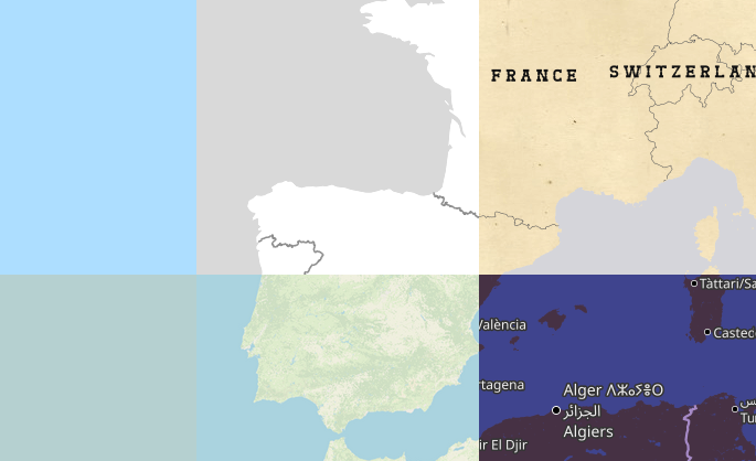
Let’s imagine that you’re a pizza delivery company, and you’ve got an app that shows where you are, where your customers are and where a delivery person is between the two. Obviously you need some sort of map that shows the three in context. You can’t use Google Maps for cost or other reasons, and whatever framework your using will accept raster tiles in the almost universal format https://server/Z/X/Y.png, so why not use OpenStreetMap’s standard layer? After all, it’s free!
Well:
Posted by NADARAJ SARANYA on 17 May 2024 in English.

Amazing Experience ……..
The open street map foundation is an international not - for - profit organization supporting, but not controlling. the OSM project. it is dedicated to encouraging the growth, development and distribution of free geospatial data and to proving geospatial data for anyone to use and share. The OSMF had quite recently Started a worldwide membership campaign with the objective of growing and diversifying OSMF membership in regions where there are very low or no OSMF members.
I am proud to say that I was part of this campaign. On the first few virtual meetups via Google meet, I had promptly signed up for the campaign Ambassadors role as I believed I could use whatever little ideas and experiences. I have learnt a lot about community.
thank you for the wonderful opportunity.
Providing updates! The OSM Wiki of the OSMF Membership Drive Campaign 2024 Plan is in the wiki: osm.wiki/OSMF_Membership_Drive_2024
We will also provide updates and have a space for feedback in the Community Forum using this thread: https://community.openstreetmap.org/t/updates-osmf-membership-drive-campaign-2024/109280
Someone is littering openstreetmap all over the world with roads that do not exists
Welcome to the seventh OpenStreetMap NextGen development diary.
This week, I focused on delivering core website functionalities and website and migration script optimizations 🚤.
🔖 You can read my other development diaries here:
osm.org/user/NorthCrab/diary/
📖 This project is open-source and publicly available:
https://github.com/Zaczero/openstreetmap-ng
🛈 This initiative is not affiliated with the OpenStreetMap Foundation.
In Case You Missed It…
OpenStreetMap-NG is planned to have its first development release at the end of this month, May. After this milestone, the project will be open for new contributors! My current work focuses on delivering on that promise, finishing the core functionalities, and stabilizing the code.
Originally posted in diary #5.5.
New Fast Rendering Engine
One of the highlights of OpenStreetMap-NG is its brand new, super fast object rendering engine. It’s a significant improvement over the current solution.
For example, rendering all of Poland (about 1500 ways) takes a mere 34ms.
This one will be a very special one! I am working hard on finishing a big functionality and need probably 1 more day. You will be amazed of what progress has been done this week. 😎♨