Diary Entries in English

Recent diary entries

Posted by alexkemp on 15 November 2016 in English. Last updated on 16 November 2016.

…than to go out mapping with him in the face of an English soak-to-the-skin drizzle.

I’d gotten an invite to a “Shakespeare Schools Festival” for Friday 11 November at Gordon Craig Theatre (4 schools, with Micky’s Presdales School on first with an astonishingly good extract from The Tempest).

Friday was dry, but the following day was a classic English day (which is to say, it was wet). Just as the Inuit are said to have 32 words for ‘snow’, we English have 32 words for ‘rain’, and this one was “drizzle”, which is a light rain that looks ever so innocent, but will be running in small streams down the inside of your trouser legs in 30 minutes if you do not have the correct clothing.

I was fine. I’d bought a Mountain Warehouse Extreme ISODRY 10 000 fully-waterproof jacket (Mountain Warehouse have a store in Nottingham centre, so I could try it on before buying; it is not only fully waterproof but also breathable). After an hour I was perfectly dry, but their jackets were soaked through, poor little sots. We did both sides of one little road then quickly scooted back home.

I did take a photo of them & Buddy the dog, but their mum did not want them plastered across an international Diary page. So, instead, I present to you (ta-da-da-daa-da-daaa! (fanfare)) more Ware Khazis photographed on Queens Road, Ware:–

See full entry

Location: Ware, East Hertfordshire, Hertfordshire, England, United Kingdom
Posted by Christian Ledermann on 15 November 2016 in English.

Since the beginning of August 2016 I mapped more than 2000 Schools in the UK. This was made possible with the help of schools.mapthe.uk which combines Ordnance Survey Open Data with the data of EduBase and the Scottish Government. So far the Application has not gained much traction, only 4 Mappers actually added something to the map with a median number of 17 edits. So I am wondering if there really is a usecase for this kind of application or if I am just wasting my time and money to make this publically available. Also it raises the question if I should proceed this route with other specialized applications e.g. to add the hospital grounds.

For years, I knew there was an address hole in OSM along Eglinton Avenue East. Querying Nominatim for an address would often return a location ≥ 5 km away from the real result.

Then came Metrolinx’s clean up and import of address ranges. Folks might turn their noses up at address ranges, but at least ranges give you a location within a few metres without adding millions of nodes. This is good enough for Metrolinx’s commuters, and improves the map.

A couple of days ago, I had to look up an address while mobile on Eglinton East. All I had was my phone with Google Maps. I put in the address, and Google suggested somewhere really far from where I’d expected it to be. Oddly enough, Google was suggesting a location in the general area that OSM always used to return. How nice to know our addresses can be more useful than those provided by a corporate entity!

Location: Victoria Village, Don Valley East, North York, Toronto, Golden Horseshoe, Ontario, Canada

One of the most important uses of the map during car navigation is to find the correct exit off a motorway to get to a destination. Missing an exit can be quite costly in terms of the time and fuel wasted in a much longer route than desired. In OSM, the tags that help to map this information are highway=motorway_junction(exit number) and destination(destination sign).

The Mapbox data team has updated over 247 motorway exits and 1285 destination sign information in United States & Canada in the last year. Here’s the workflow we followed to create tasks on the Mapbox Tasking manager if you would like to create a community project for your own area. This workflow creates convenient tasks that can be distributed to review the data on individual highway routes on checkautopista2 for a particular area of interest.

screenshot 2016-11-14 13 12 21

1. Defining the area of interest:

Draw a boundary for the area of interest you want to cover in JOSM tagging as area=yes and save it as .osm file.

See full entry

Posted by Zverik on 14 November 2016 in English. Last updated on 7 December 2016.

Last time it went pretty well, so let’s try another long-standing issue. Namely, #1274.

You can register or log in to the OpenStreetMap website using a social account: Facebook, GitHub, Google. The thing is, most of us have many social accounts, but you can only link one to your OSM profile. If you click a wrong button, you will have to either go back or register a new account. You cannot log in to your account using different social buttons.

For me, that is a problem. I would like to not remember which of the buttons I clicked when I tested the social login, and which of these is linked to my main OSM account. For that I would like a social accounts management in the settings page. Alas, I don’t have time and skills to add that, but I have a hope that somebody has. And for that I’m willing to pay a small grant: a hundred euro, like the last time.

The offer stands for two months: the pull request to openstreetmap-website should be submitted until 15th of January and merged until 15th of February. Right after merging I will transfer 100 € to any given credit card or bank account.

Posted by ElliottPlack on 13 November 2016 in English. Last updated on 14 November 2016.

There is an interest in modeling 3D buildings on OpenStreetMap and in the community. Updates from map providers like Mapbox and Mapzen now support complex 3D building rendering. This diary gives an overview of the process used to add 3D buildings in Baltimore.

subject buildings

Background

I am always looking for ways to improve the map of my hometown. I looked to Baltimore for some buildings to add in 3D. I found two to start.

The buildings, the Hyatt Regency Inner Harbor and One East Pratt Street, are prominent on Baltimore’s Skyline. Their representative shapes in OSM were blocky and missing parts. Having never understood the “simple” 3D mapping technique, I set out to learn how to improve them.

Learning Simple 3D Buildings

See full entry

Location: Downtown West, Baltimore, Maryland, United States
Posted by joost schouppe on 12 November 2016 in English.

Community power

While building the program for State of the Map, the program committee had to say no to several people who wanted to talk about their local community – their successes and their challenges. As a kind of compensation, we added a local communities panel (video) and a local chapters congress to the program.

But during the preparation, I also got a lot of feedback from people who couldn’t make it to State of the Map: money, accidents, visa. I got feedback from Brian Pangle (UK), Felix Delattre (Nicarague), Clifford Snow (US/Seattle), Marco Antonio Frias (Bolivia), Redon Skikuli (Albania), Mohamet Lamine Ndiaye (Senegal), Yantisa Akhadi (Indonesia) and Michal Palenik (Slovakia). Most of them didn’t have a chance to be on the panel, or even make it all.

Some of their ideas did make it to the Local Chapters Congress, and helped put things in motion. For example, finally we have the option to follow comments on Diary posts! And there’s talk of putting some money into OSM.org website development for things like massive local messaging, which was a recurring theme there. That might involve helping Gravitystorm’s project to simplify the OSM.org codebase, as that would make contributing code that much easier. Also the idea to allow OSMF membership without payment was mentioned, which was an obvious frustration during the Local Chapters Congress.

What is important to me, is that it goes to show that focused community action can shift the focus of our dev team to issues that would otherwise be lower on their priorities list. I hope we can repeat efforts like this at the next SotM, hopefully even stronger.

This post does two things. First, it will give you, the local community builder, a lot of ideas about things you could do to work on a tighter and larger community. Second, it tries to set an agenda. It offers you several ideas which you could adapt, promote or realize.

Content

There are three subjects:

See full entry

Posted by LogicalViolinist on 11 November 2016 in English.

Seeing as ID and Mapbox are pushing to incorporate wikidata into OSM, I thought it would be a perfect little project when mappers have nothing better to do or in their downtime.

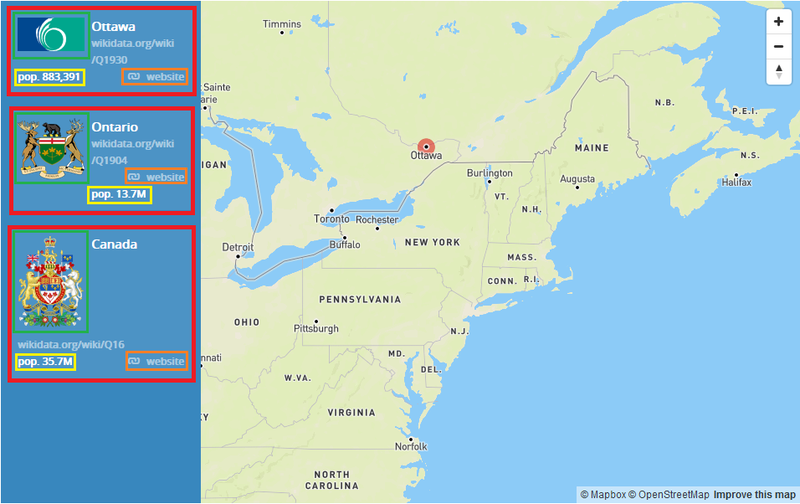
The wikidata link can help developers get vital information like the current population, current mayor, flags, coat of arms,etc. The list goes on. This is a lot of data that can’t necessarily be encoded into OSM. This would help simplify the use of OSM data for small developers. Take for example mapbox’s example: Mapbox Data rich map

The items in the red square have all been obtained via the wikidata api using the wikidata ID. The flag in the green box, the population in the yellow, the website in the orange box.

See full entry

Location: Aylmer, Gatineau, Outaouais, Quebec, Canada
Posted by alexkemp on 10 November 2016 in English. Last updated on 11 November 2016.

Do other parts of the world display odd and/or strange figures on their garage tops? It certainly has proved to be a popular meme in the parts of Nottingham that I’ve mapped (see also [1] [2] [3] [4]). Here is the latest, a stick figure in a top-hat on the top of a garage in Westdale Lane East, Gedling:–

stick figure, Gedling

Location: Gedling, Carlton, Gedling, Nottinghamshire, East Midlands, England, NG4 4BH, United Kingdom
Posted by yogi_ks on 10 November 2016 in English. Last updated on 25 November 2016.

State of the Map is one of the biggest OpenStreetMap conference where people who know about OpenStreetMap and want to learn about OpenStreetMap come together. Being part of SOTM-Asia conference in the Philippines with the community and talking to them in person was amazing. It was a great exposure for me to learn how community together built an amazing map of their country/town/village and know the stories behind them.

Sessions/Talks

This was my first State of the Map Asia conference and OpenStreetMap community from more than 10 countries, not just Asian but other parts of the world had also gathered to share their experiences and learnings with fellow community members. The conference exhibited 8 state of the country talks (Japan, India, Taiwan, Sri Lanka, Philippines, Nepal and Bangladesh) which presented great insights on how community is coming together to contribute in different countries and various challenges faced by them. The keynote address by Kate Chapman, Nama Budhathoki, Taichi Furuhashi and Dr. Mahar Lagmay were all very inspiring and encouraging.

See full entry

One of the workshops offered at the conference is OpenStreetMap, so I logged onto OSM this morning and hope to get really good at this mapping feature. Manchester-by-the-Sea owns a number of open space parcels outright and partners with others on the North Shore. I’d like to see efforts coordinated.

Location: West Manchester, Manchester-by-the-Sea, Essex County, Massachusetts, 01944, United States
Posted by andygol on 9 November 2016 in English.

Relations is a feature that is built over another data using their geometry or metadata. Thus participants of relations can be points, ways, and other relations. They may present as physical objects of the world as well as mental objects, such as bus routes, borders, turn restrictions and etc.

So the way representing the road and tagged with highway=* tag can be a part of different route relations that run along it. Spliting or removing this way that is a member of relation will break all relations to which it belongs.

To avoid this you need to download all parent and child objects for this way (relation).

download object dialog

After you download all the data, JOSM helps you validate your edits and deal with possible conflicts.

Hit Update Modified (Ctrl+Alt+M) before any upload to avoid possible relation conflicts.

Fixing broken route relation

If you are faced with the broken relation of route and you have information about it, Relation Toolbox will help you cope with the work.

See full entry

Posted by PlaneMad on 9 November 2016 in English.

You’ve probably already seen the video of the Fukuoka sinkhole swallowing up large parts of an intersection. This obviously necessitates a map update, as it could be a little bit of an inconvenience to drive on this stretch.

In Japan updates are quick, both on the map and in the real world. From the detailed traffic restoration plan the road might actually be back to normal before any other map gets updated ;)

Location: Gionmachi, Hakata Ward, Fukuoka, Fukuoka Prefecture, 812-0018, Japan
Posted by PlaneMad on 8 November 2016 in English. Last updated on 9 November 2016.

Wikidata, the crowdsourced database of structured knowledge by the Wikimedia movement has grown to over 24 million entries and by now has structured information for every major settlement on earth. These are extremely useful properties like multlingual labels, statistics like populations and GDP, and other related information like politics, history and media about the place (See London, New York City, Timbuktu).

Geolocated articles on Wikidata, with those added in the last year highlighted in pink. Source: Wikidata Map

Current state of multilingual tags

See full entry

Posted by SJDRRMO on 8 November 2016 in English.

HELLO USERS! Greetings!

I just would like to know if Openstreetmap has security measures to detect and correct false data entries.. Example: displacement or replacement of critical buildings. What if somebody accidentally or intentionally relocated some of your buildings? What is our assurance that what is being presented is new and true? Any thoughts on this? Thanks for the comments..

Posted by alexkemp on 7 November 2016 in English. Last updated on 9 November 2016.

If it’s funny then it gets into these Diaries (possibly a “Never Mind the Dog…” series? [1]).

This one was on the end of a garage facing the street, on Digby Avenue in Mapperley (a very posh area of Nottingham but with, I’m delighted to say, very approachable & down-to-earth occupants) (a complete contrast to some other posh areas, who are very up themselves):–

garage notices

Location: Woodthorpe, Arnold, Gedling, Nottinghamshire, East Midlands, England, NG5 4JY, United Kingdom
Posted by srividya_c on 7 November 2016 in English.

Over the past 7 weeks, Mapbox Data team completely concentrated on aligning and improving the road network of Taiwan. With regular interaction with the community in our mapping ticket and a series of diary posts about our findings, progress and learnings, we have reached the finish line of the task.

image

Area Covered

Current Status

Using updated Mapbox satellite imagery and Strava heat map and different offsets with respect to Bing imagery, the data team has aligned 64,680kms of road network in Taiwan which forms the 54.4% of entire Taiwan road network. The overall project consisted of 43 tasking manager tasks covering 27,000 sq kms which is 74% of total area of the country.

See full entry