 OpenStreetMap

Unlike many Indian cities where ambiguity in street names is common, Chennai stands apart to this. In Chennai, street names are displayed at the end of each street, not just the main roads even interiors roads have names displayed. I am in Chennai for a vacation, having noticed this I set out on a field survey for street names around my residence. In the survey, I could observe that, streets less than 50 metres in length and streets where four-wheel vehicles cannot enter also had a specific name displayed at the end of the street. Such detail in public information helps in creating perfectly labelled maps and gives the mapper knowledge of where street with a particular name begins or ends. With such information, Chennai is a delight for open mappers and a comfort for service delivery. While streets in some localities are well labelled on OpenStreetMap, some effort is required in others.
Diary Entries in English
Recent diary entries

I am Ataur Rahman Shaheen, student of Hon’s 3rd year of Statistics department at Dhaka College.I am an executive member of YouthMappers of Dhaka College chapter.
First of all i would like to thanks a genius cannon and pioneer of OSM Bangladesh, Ahasanul Hoque. He introduced Bangladesh with OpenSteetMap and did very hard work and gave his valuable time to OSM Bangladesh. Even sometimes postponed his most favorite work, reading books for OSMBD. And now its only his credit that OSMBD successfully running in Bangladesh. He also give his full support and help for YouthMappers, Dhaka College chapter.
YouthMappers Dhaka College chapter is a very active chapter. Every month it arranges a mapathon and monthly meeting to share each others’ opinions, work progress, experiences, problems and solving by teamwork.
I love gardening. So I love mapping. Because mapping is like gardening to me. People do gardening to increase beauty of their surroundings and nature. Mapping also increases the beauty of our planet. It makes the map more useful and easy to all.
Flowers and trees are the best for gardening. Planting trees is the main part of gardening. We water our garden for good growth of plants. We also use fertilizer and insecticides for healthy and rich gardens. After all of that, flowers bloom in the garden and it makes nature more beautiful.
OpenStreetMap is the best for mapping. Similarly in the OSM mapping the base is drawing homes & roads by using satellite imagery. Then we put many information items in the map. We do fieldwork for every single information point to complete the map. After all this work its looks like charming garden full of flowers. That means it’s a totally complete, easy and very informative map. And that makes the world more beautiful.
So I think everybody should doing gardening for nature and mapping for a better world.

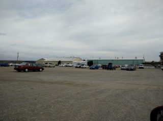
These are the Markham Fair grounds. I missed out some of the grass, and the track, but this is pretty much what you get. It doesn’t look much like tourism=theme_park, does it? But that’s how it’s currently tagged: Way: Markham Fairgrounds (43934707)
Strangely enough, it and many others like it in Ontario are tagged as theme parks. Now they might have a midway for a week or so during summer or fall fairs, but the rest of the time, they look like this.
The previously proposed amenity=show_grounds would be better for most of these. The ones that have permanent installations, like Canada’s Wonderland, should stay as theme parks, so a little local knowledge is required.

Hi,
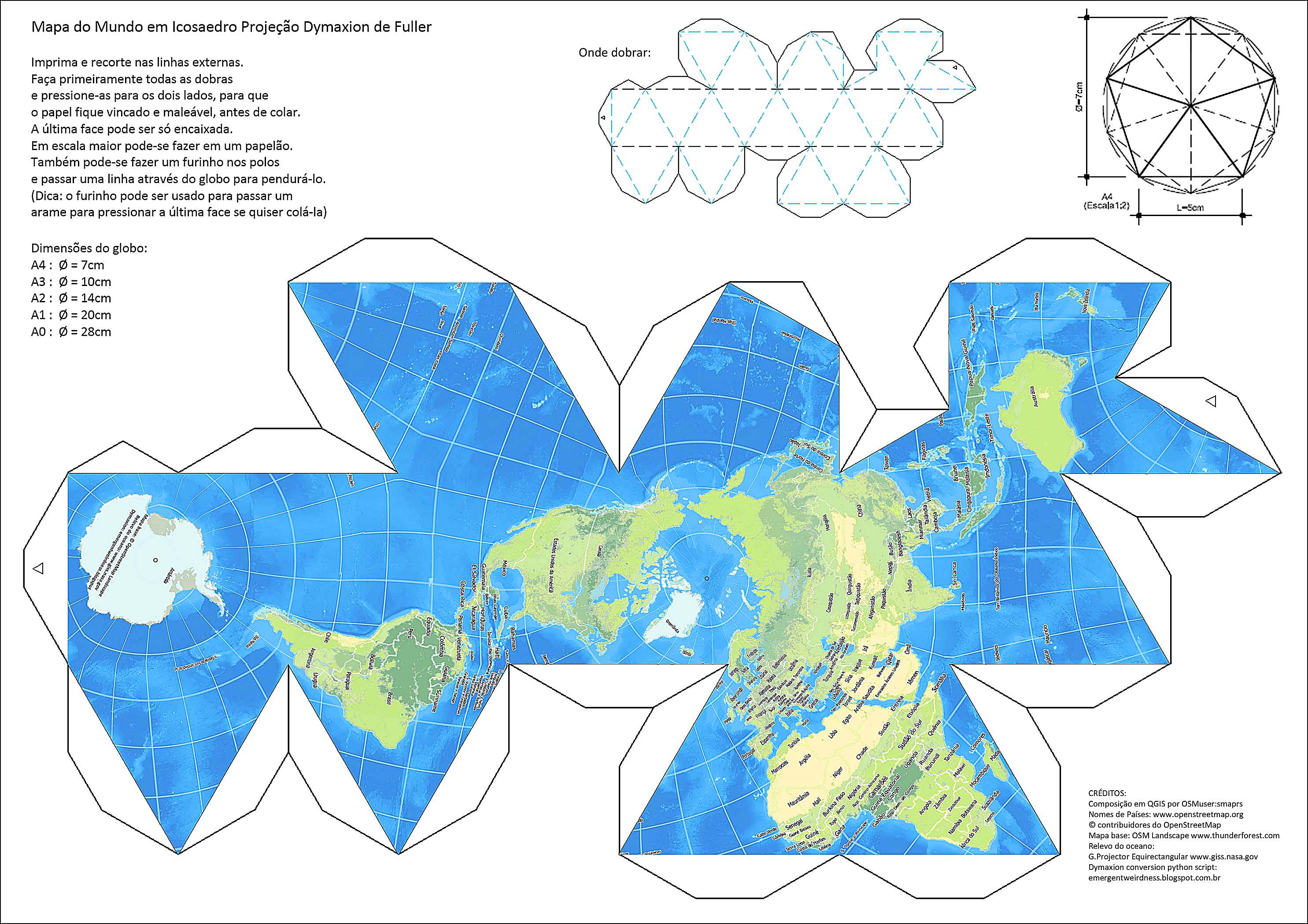
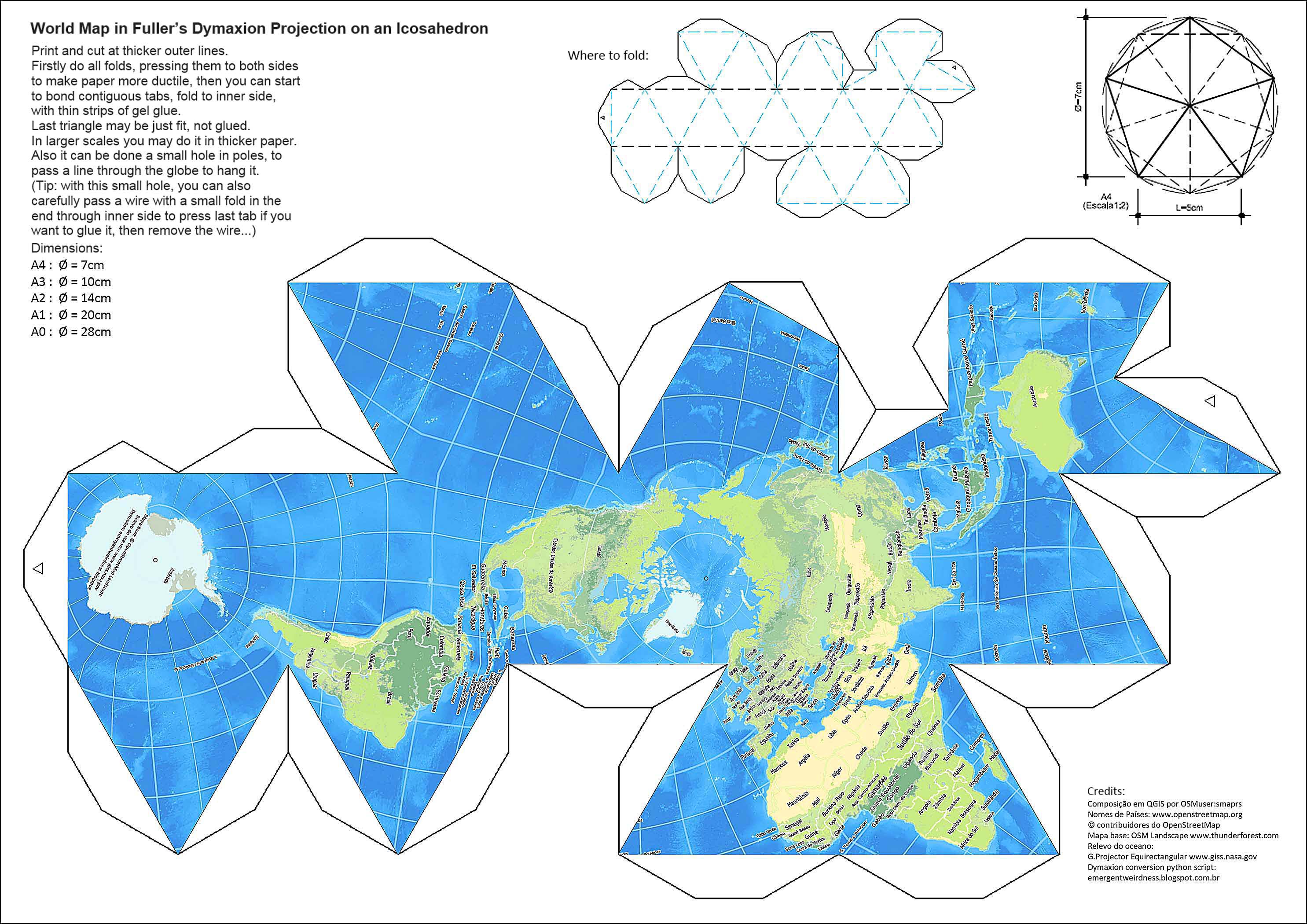
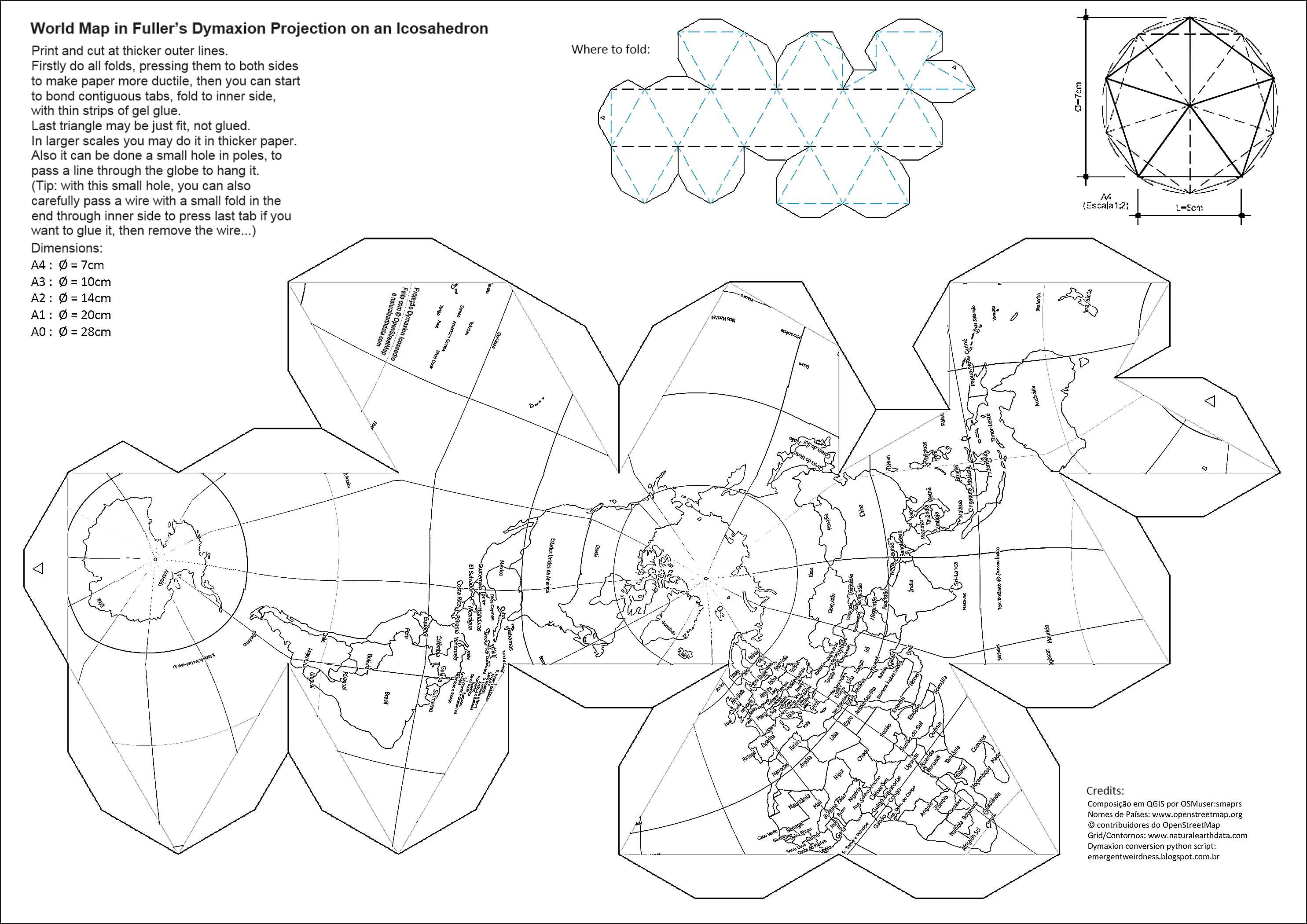
Here there are two OSM based print-cut-fold-and-glue artwork for kids (and not so young), to share and help to spread OSM and geography interest:
World Map in Dymaxion Projection
Composed by OSMuser:smaprs (with QGIS and image editor) and with a little help from Brazilian OSM Comunity and others. - Free for copy and share under CC-BY-SA 2.0
Country names: www.openstreetmap.org © OpenStreetMap contributors
Grid/Country borders at: www.naturalearthdata.com (blank version)
Base Map: OSM Landscape www.thunderforest.com (colour version)
Ocean Floor Relief: Global Map Projector Equirectangular www.giss.nasa.gov
Dymaxion python script at: www.emergentweirdness.blogspot.com.br
To fit in Dymaxion Projection the OSM Base Map had to be firstly converted to a Plate-Carreé projection in 2:1 aspect ratio PNG picture. This was done in QGIS.
English version printable: OSM World Landscape: wiki / Blank Globe for colouring: wiki

Travel planner Sygic Travel now displays places from OSM. Independent travellers can plan their trips easily and they can create detailed travel itinerary or get inspired what to see nearby them. You can try it at https://travel.sygic.com.
We also want to make OSM better for everybody and contribute to keeping the OSM up to date. We will encourage our users to edit the data in OSM and we will synchronize the changes in our database to OSM.
It’d be great to hear your comments about the planner.

At 09:45 UTC the OSM sites are back up again after ‘too many people accessing’ notices for ~45 minutes. Do we have some info on what was happening, please?
The Existential Question
08:45 5 November
Having slept on this I’ve come to realise that it is far more important than at first I realised, since it concerns the very existence of OSM: in what form is it going to continue? (all life on this planet grows, withers or transmutes; what is OSM going to do?).
In short (there is fuller info with links at bottom):
- 28 Oct: zerebubuth (Matt Amos) opened a discussion on Github : the tile-servers are hitting capacity; what policy is OSM going to follow in the future? Restrict to open-source apps or restrict to publicly-accessible sites (notice that both options involve denial of access)?
There are 59 machines internationally — including 20 globally distributed tile-caches — serving up OSM tiles to anybody that asks for them. Funded entirely by donations. Outbound peak traffic on tile.openstreetmap.org (served from cache) peaks at 1 Gbit/sec (6,800 GB/day; 528 million requests at 13.6 kB/request), but a recent measurement indicates that just 11% of this is supplied to OSM websites. The rest is 3rd party sites and apps.
- 4 Nov: the system seized up tight.
ironbelly had to be restarted (look at ‘uptime’) and re-init (at a guess) on the ramoth network (look at ‘memory’ and also ‘network’ - the server system became saturated with FIN_WAIT & TIME_WAIT connections for all of 2 Nov, possibly indicating TIME-WAIT loading problems)
- As soon as you provide something good at zero cost there is large demand. How is OSM going to respond?
Added at 24:00 4 November:
Zero assistance from OSM Folk, so had to find an answer myself. Took a long while.
GNJ Motorsport (removed - thank you) - this is known as Profile Spam.
0 Edits; 0 Traces; 0 Diary posts; just 1 Comment on day of Profile creation to make sure that Google will find the spam.
Please remove this turd.
One thing noticed by seasoned webmasters is the clever spammers that post an innocuous message which they leave until suddenly it gets edited into being a conventional spam message (reported on SFS as sometimes being left untouched for years) . That behaviour is made more difficult on OSM since many many folks make just one edit & are never seen again.
I’ve spotted a lot of these nonsense Diary postings. This is simply the latest (the single letter ‘A’). On my own website I simply deleted such users; if they were not spammers, then they were a total waste of disk & db space. However, after 7 months mapping for OSM my anti-spam brain has suddenly clicked into place; these potential spammers need watching. That needs to be done programmatically (links of latest updated diaries crosschecked with original postdates) but in the meantime I’ll assemble a watchlist here (almost all these folks are 0 Edits 0 Traces 1 Diary):—
I’ve started seeing winery-operated “tasting rooms” popping up along highways, so I figured it made sense to some up with some sort of standardized tags to use on them. After some feedback from the talk-us list, I’ve settled on this tagging scheme for now.
In addition to the standard stuff (address, contact info, etc.):
For the winery itself:
- landuse=vineyard
- craft=winery
- tourism=winery
For the tasting room, whether or not it is on the winery property:
- amenity=cafe (if it also provides food service)
- bar=yes
- beer=no
- liquor=no
- drink:beer=no
- drink:liquor=no
- drink:wine=yes
- tourism=attraction
- wine=yes
- wine_tasting=yes
- Pakistani ‘Escort’ whilst Mapping in Dubai (removed -thank you) (‘hot body language’ promised)
- Burger Grill Varlemann (removed -thank you) (0 Edits, 0 Traces, just 1 spam diary entry)

Editing OSM tags is downright difficult at times, but it is one of those many times in life, where once someone teaches it, you truly know it.
I want to leave this note of thanks to the people supporting the help.openstreetmap.org website. I am super thankful for the excellent responses there. It is easy to use, and I do not have to wade into a mailing list or online forum to ask a question. This low-barrier-to-entry website makes asking potentially “stupid questions” a lot more comfortable, especially with the in-line search feature that checks for similar questions as you type.
But the website’s real strength is the OSM users who monitor the question queue and take their time composing some excellent answers, with links and further readings. My only complaint is not having more capability to offer my thanks, other than clicking a “thumbs up” button. This help system really makes me feel connected to the OSM community.
My target was to finish mapping a patch local to me in Nottingham, bounded (roughly) by The Wells Road, Woodborough Road, Westdale Lane West/East and Carlton Hill. It took 7 months & is now complete.
I’m a careful & thorough kind of chap and thought that I’d done a good job. Nevertheless, I was really pleased to recently come across OSM Inspector, which is provided by Geofabrik Tools to be able to quickly find a whole range of errors. There is a wiki page for it and, naturally, it provides virtually zero help in using the tool. I’ve used it for just a couple of days, so here is…
An Idiot’s Guide to OSM_Inspector
or, OSM Tools Considered Useful After Mapping
- Open OSM Inspector in a browser of your choice
- Type your desired map location into the Search box & click search
(for me “nottingham”) - Click on the desired link from the Results box
(for me, “Nottingham, East Midlands, England, United Kingdom”) - You will now dimly see your desired location on the map
[my view in your browser]
(there is a slider next to the Base Layer option box which will adjust the contrast of the base map) - Click the ‘+’ and/or drag the map until you have the correct territory before you in the screen
- Click on the View dropdown & choose “Addresses”
(there are a lot of other options, but that has been my activity all this year) - Click the “Buildings” checkbox OFF to allow the errors to be seen
- Click on an error within the map to show that selection in the RHS selection panel. If you use JOSM & have the RemoteControlPlugin installed (not needed if > v3715) + JOSM is already running, then clicking on the icon will switch JOSM to the current view + load the data (I haven’t tested that yet). Icons are also provided for iD + for Potlatch2.
It was mostly very useful for finding + fixing errors in my mapping. I found only 2 useless aspects:-
One class of quality improvements in the US is Railway Crossings. The original TIGER import mostly connected railways to highways or crossed with a duplicate but unconnected road. There was no bridge or crossing information to assist.
It can be useful to have railway crossing information available for navigation. In 2015, MapRoulette defined a challenge to review all railway crossings. The first version of the Railway Crossings challenge at MapRoulette used the points defined by the US Federal Railway Authority. Many of these crossings had already been corrected by map editors during normal QA. The challenge began with 120K crossings to review. This was reduced to some 70K points by the time MapRoulette V2 came out. The partially completed challenge was not migrated because the MapRoulette V2 features were being tested and improved. Although this is not the ideal type of task for MapRoulette, I enjoyed being able to knock out 5 in a row without much effort (unless in KY, PA or WV!) It also is ideal for an armchair challenge - only a few are difficult to make out from the air.
Because I would typically correct nearby crossings when fixing a task (others may have also), I wondered if identifying remaining crossings with a topological analysis would result in fewer false positives, and fewer already-completed tasks to review. So I set up a POSTGIS instance and tried to construct queries that would identify problem crossings. That proved to be too difficult:
- I couldn’t tell if OSM2PGSQL or Osmosis populate the database with the full OSM topology, including where nodes are shared, and even if so, what would such queries look like.
- I only had 8G of RAM, and didn’t know how to construct queries for POSTGIS that would handle US-sized data in a reasonable time.

Recently, I have mostly been adding house addresses around my neighbourhood.
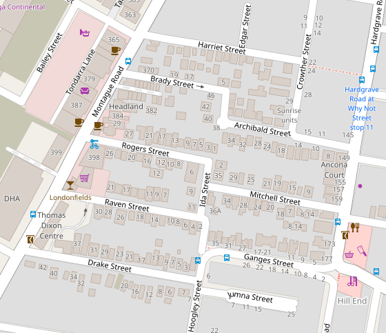
One issue I am running into is that I can’t figure out the best way to set the address for an apartment complex.
I am currently trying to tag individual buildings with building=apartments, and an area that encloses all the buildings with the address tags (like addr:housenumber, addr:housename, addr:street).

On my final day mapping Porchester Gardens last Tuesday 25 October (the day before my birthday) (67, since you ask) I photographed & recorded the name of a house near the top of Sandford Road. Only long afterwards did the name of the building strike home: “Coronation Villa”.
Porchester Gardens was divided into lots for allotments & houses following it’s purchase on 26 March 1887 (history: [1], [2]). The first house is generally reckoned at 1889, and single houses were built on each square in the Gardens in the 10 years or so that followed purchase†. Odd houses were built throughout the next years, but it was the period between the 2 World Wars (1920s & 1930s) that saw the true spurt of building as gardening allotments were abandoned & houses built on each plot (all except one).
I find it very interesting to track the history of building, but the difficulty is to find the start_date for enough houses (especially the old ones). And that is where the building-name comes in, and exercising little grey cells…
This house can be seen in Google StreetView (it’s the double-fronted detached house with a blue door, but I cannot show that here). Here is the panel-name (not very clear):


http://hiu-maps.net/hot/1.0.0/ashgabat-17oct2016-flipped/{z}/{x}/{y}.png

This is the URL for use as a “Custom” layer when editing OSM for Ashgabat city, current as of 17 October 2016.
Это – URL (веб-адрес) для нового спутникового снимка г. Ашгабата от 17 октября 2016 г.
No-one seems to remove spam anymore. Here are the latest turds:
- عمليات طفل الأنبوب و الحقن المجهري في تونس (user: DR Skander Ben Alaya)
(translation: “operations tube children and ICSI in Tunisia”)
(spam for a Tunisian-based gynaecological clinic, supposedly from one of it’s doctors) - Globale Protection (user: Globale Protection)
(spam for web security company based in the Ivory Coast, Africa) - Надувной мешок Lamzac от “Junkstore” (user: Junkstore)
(spam for UA company Junkstore)
(zero map edits since 5 Oct; pure spam)
Sat 29 Oct update: these 3 removed (thanks)
I’m located in carteret new Jersey. An industrial town surrounded by oil refineries. The train tracks are less than a mile from where I live
Here is the Kent Road big brother to the stone/metal guardians that have featured recently ([1],[2],[3],[4]) in these diaries:—

The photo above required digital zoom to be able to show it closely. Here is a more distant shot in better quality:—