
I have two new T-shirts! :-D

 OpenStreetMap
I have two new T-shirts! :-D
Dear mappers help relief efforts updating OpenStreetMap maps. Thanks for the input! Here the task
Our data team at Mapbox along with the OSM-TW community recently completed mapping and aligning road network in Taiwan. The realignment was carried out mainly based on newly rendered Mapbox satellite imagery and Bing imagery.

Progress over Taiwan during road network realignment.
During this project, we observed offsets in Bing imagery in several areas when compared with Strava and GPS traces. All these offsets are now included in the Imagery Offset Database for the wider community to use.
Today I am going to update my diary about the help of Mapillary photos to update my village roads. Because of canopy cover and poor resolution of Bing Imagery I missed these road before and now it’s on map. It’s a 10 minutes demo.
In Mysterious Markers (22 Oct) I showed the following ancient markers from the NCWW:

Really, this was a case of “Nothing to see here, please move on” as they were simply older variations on the modern “Sluice Valve” (SV) & “Fire Hydrant” (H) ‘grave-stone’ wall plates used by Severn Trent elsewhere in Nottingham. As escada pointed out in the comments, both hydrants and sluice-valves can be mapped (though currently shown only on the specialist osmhydrant.org or openfiremap.org). The kicker came in a comment from Andy Mackey, giving a link to a blog post from Chris Hill in 2012. A 2016 comment in that blog post said that the UK authorities consider mapping Fire Hydrants to be a terrorist act (no kidding):
25 TH 10 2016
EDITED FROM 1250-442 AM
What ave learnt
how to differentiate the road feature requirements suitable for different areas,
i.e remote areas have limited road tags to highway unclassified,
urban areas go up to primary ,
The improvements of “OSM go” are going on. I was quite proud, as the OSM weekly mentioned it. The handling and the control is usable now. There are keyboard- and URL-commands. The rendering includes building levels and train tracks. The first “Layer” is included: Keepright. It is motivating to clear the errors, marked in the 3D world. A object selector does show its OSM tags.
And did you ever see this in any tool or service?: OSM, rendered in stereo, to see it in a Google Cardboard? OSM go enables you to walk or fly through the virtual world of OSM

Read all details in the OSM-Wiki page for OSM go . There you will also find details to ongoing component states and rendering details. And a todo list at last.
We had a discussion about retiring the use of exit_to in favor of destination for motorway / trunk exit tagging in the US a while ago. Since then, a shift has happened and a majority of exits is now mapped with destination instead of exit_to. This is great for navigation applications that rely on detailed signpost information, such as OsmAnd, maps.me and Scout.
With the situation in the U.S. so much improved, a next obvious target for mapping is Canada :) The situation there has been improved already by the community, but also by organized mapping by Mapbox and Telenav. Still, about 1200 exits remain that are tagged with the ‘old’ scheme. With the help of my colleagues at Telenav we put these in a MapRoulette challenge.
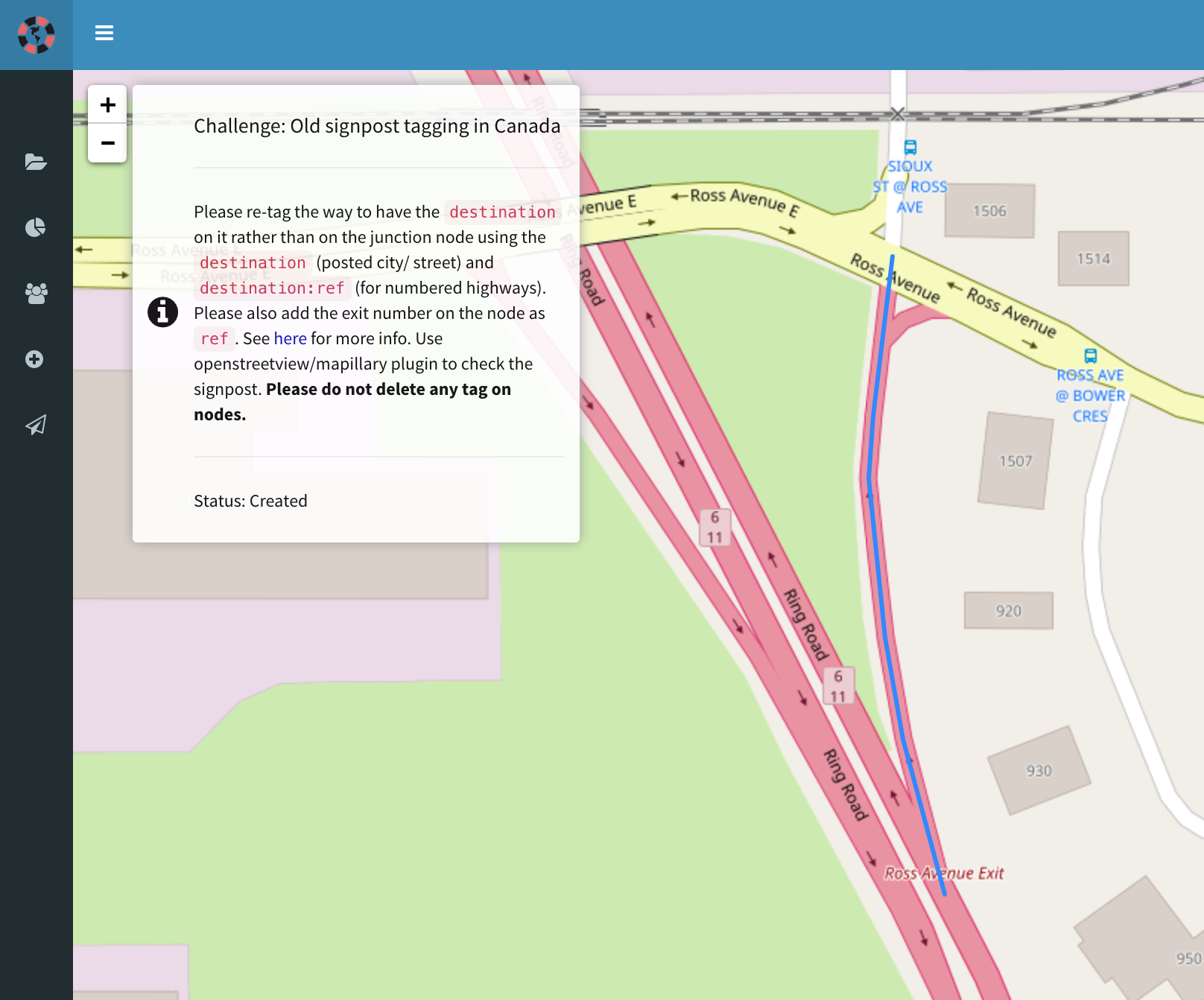
Because both OpenStreetView and Mapillary have good coverage in Canada, I think we should be able to update most of these exits to use the new scheme. Let’s give this a go!
Satellite imagery is one of our common source of data for mapping, however, not all imagery is exactly aligned to real world features. Every mapper should be aware of this and should consider adjusting imagery from aggregated GPS tracks or from features which we know have correct location.
The usual approach is to align the imagery to GPS traces as best as possible using the Adjust imagery offset tool before making any edit.

For those that do not already realise: I appear to be as obsessed with the stone creatures that Nottingham householders use to guard their homes as they are. Here is the latest one from Robinson Road, Porchester Gardens:—

Current values for Porchester Gardens’ houses seem to be somewhere north of £250,000 GBP each (5-bedroom detached houses are common on those slopes). With more than 800 properties in that neighbourhood, the total value is climbing rapidly towards the £billion GBP mark.
Of course, there’s always someone that will let the side down…

The latest survey of Porchester Gardens — just another couple of days surveying before it should be completed — has unearthed more of these lead markers and, possibly, has answered what they are. Here are two pictures from today’s trip [1] [2]:
I’m currently updating Sardinia street names, using open data (IODL) from Regione Sardegna.
The best data source is the Geo Topographic Database (http://www.sardegnageoportale.it/index.php?xsl=1598&s=269925&v=2&c=8831&t=1) . It covers 125 towns out of 377. The data is pretty accurate.
As a secondary data source I’m using DBT Elemento stradale (http://webgis2.regione.sardegna.it/download/). It covers all the towns, but is older and many street names are missing.
I’m updating the names of existing OSM highways. For missing roads I’m using Mapbox Satellite first.
Currently, we have acceptable (but not ideal) tagging scheme for access restrictions. I’m talking about access=* key and its values. Here, I want to tell something about an application of this scheme in terms of topology, data interpretation, and data architecture.
OSM documentation says that it may be used on nodes, ways, closed ways (use on relations is unspecified, but it’s not prohibited). And many people take that literally. Let’s review some cases.
access=* is often assigned to a node, representing a barrier. Many mappers have an idea that it is way easier to add this tag to a gate, liftgate or another kind of barrier to indicate that access restriction starts here. In such cases, adding access=* to a highway=* is often omitted. A common argument for omitting it is that usually, navigation software starts the route planning from a point, which is publicly accessible. Then, analyzing the road network, it should avoid crossing those points with access=* restriction, if possible, just like it does with user-defined avoidance marks.
But there is a problem with this method. Having a road, divided into two parts by a node with access=* tag, it is impossible to tell, to which half this restriction is applied. This problem has only heuristical solutions, involving extensive analysis of road network. For example, it will be a nice educated guess to say that restricted portion is often a dead-end comprised of lower rank roads, while unrestricted portion likely has a connection with higher rank roads. But this kind of analysis is a problem with no definite depth, and it still doesn’t give you 100% accurate result, which is unacceptable.
This something which we have been talking for years ;). Feels so happy that it is ready now.
Maps can be displayed in Wikipedia from OSM relation. Just done it for NH1
Wikipedia —> Wikidata —> OSM
How often OSM updates Wikidata id with Wikipedia tag ?
Important note: The imagery I use as an example below is different in source from the imagery used for the MapRoulette imagery. The example below shows imagery that was commissioned by Texas itself, and is available in the public domain. The imagery in the MapRoulette challenge is licensed from Google by Texas and made available to MapRoulette specifically. So I can’t say positively that it’s OK to add this imagery to JOSM or iD, and removed specific instructions to do so.
Have you tried the Texas Cemetery challenge in MapRoulette? If you have not heard about it yet, I posted about it on my diary a few weeks ago. The short version: the friendly folks at TxDOT supplied me with a database of their known cemetery locations, we matched them with existing OSM, and if there was no match, we ask you to map it :)
If you tried it, you may have found though that it can be a bit frustrating :( Bing and Mapbox aerial imagery is often just not detailed enough to see if there is a cemetery or not in the location indicated. I discussed this problem with the friendly folks over at TxDOT, who are very excited about getting more data into OSM. They told me about some of the high resolution imagery that is available to the public through TNRIS, the Texas Natural Resources Information System. Here is an example of some of the amazing data they have:
As at the begin of every new quarter since a couple of years, I’ve updated the Contributor Statistics on our wiki.
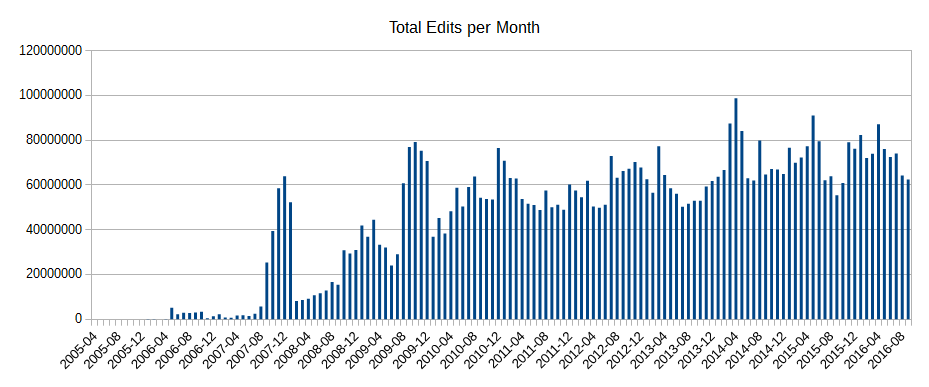
Naturally the most noticeable thing is the large jump in new users and active users starting in April 2016, which is naturally mainly due to new incoming edits from maps.me users. This is, on first principles, naturally not a bad thing, and annoyances due to bad edits aside, exposing more people to OSM is good.
What I have however noted in discussion is that the impact of the growth of the raw number of contributors is massively overestimated. For example the number of edits (not changesets) per month is essentially unchanged:
A new version of FacilMap has been released.
Everything has been rewritten from scratch. FacilMap is now based on Leaflet, AngularJS and Bootstrap.
FacilMap is an online map that aims to bring together many useful functions in a usable and pretty way onto an open-source map based on OpenStreetMap.
https://facilmap.org/myMapName. Markers, lines, routes and even GPX/KML/OSM/GeoJSON files can be added to these maps by everyone who has the link to the editable version of the map (every map has a read-only and a read-write URL), and changes are displayed live to everyone who is looking at the map at the same time. Advanced features include the definition of custom marker/line types with custom form fields and styles and the automatic generation of a map key.The most important news is that version 0.7.53 is now live on the dev.overpass-api.de and overpass-api.de server. The Rambler server will follow in the next days.
I will give details on this further below. Also below I will explain how an incident with Pokemon Go shaked my mindset about quota policies.
Before this I will present the number of the month: 74.9 percent. From 74.9 percent of the total IPv4 /24 subnets of the entire world I have observed requests in the logfiles. Amongst some random IP block owners from the logfile: General Motors, Ford, Toyota, Daimler, BMW, Volkswagen. Media Outlets: New York Times, Guardian, Der Spiegel. Further starring: SNCF, Deutsche Bahn, SBB, numerous universities and even ESRI. Of course also long lists of telephone carriers. Remember that Overpass API is a quite deeply buried and highly technical service. It is almost sure that the popularity for the combined tile servers is even higher. This matches very good with the observation that half of the public administration in Germany is figuring out how to get OpenStreetMap in their workflow.
Punchline: OpenStreetMap is by no means small. It is the de-facto standard for general purpose geodata. And if there are limits to the growth of OpenStreetMap in sight, then these are most likley the size of mankind.
This does not mean that the majority of mankind is using OpenStreetMap. Please do not forget that you cannot eat geodata. Or substitute drugs. Geodata is in important field, but not the core of the world or the internet. The statistics from above say that whoever is involved in geodata is almost surely aware of OpenStreetMap.
.


