
We’ve released a new version of our open source routing engine GraphHopper. Read here for more information

 OpenStreetMap
We’ve released a new version of our open source routing engine GraphHopper. Read here for more information
I’ve just counted some statistics on a planet file from 14th of October. Here it is:
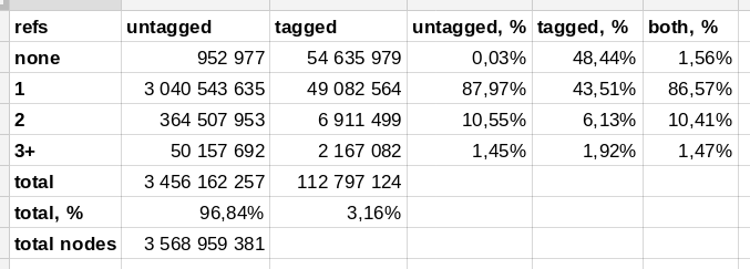
This table shows a number of nodes, both tagged and untagged, that are referenced by ways and relations. You can see that nearly 97% of 3.5 billion nodes are untagged, and most of these — 88% — are part of exactly one way or relation. Like, when you trace a building, you add four untagged nodes that are part of that closed way.
98.4% of all nodes are part of something, but only 12% (424 million) have two or more parent objects. This could help with designing a data storage for nodes.
There are equal amount of tagged nodes that are not part of anything, and part of an element. Interesting are these 9 million tagged nodes that are part of two or more ways. The taginfo says there are 2.5 million crossings and 860 thousand traffic signals, so that’s a ⅓ of that.
As of yesterday I’ve decided to restart my attempts to improve the mapping of every route in Pennsylvania one by one, from US 1 to PA 999, plus bannered routes and major old alignments, as well as unnumbered routes like the Harrisburg Airport Connector and the Central Scranton Expressway.
So far I’ve completed every numbered route up to and including US 22.
Here’s an example of the sort of sloppy TIGER mapping that gets fixed:

Again like Wardha, I am on temporary deputation to KV Pandhurna. Its been almost four months been here. Tertiary roads in the city are almost completed. Now I’ve to add POIs. Pandhurna looks pretty good now. This small town very famous (notorious) for its stone-pelting ritual ‘Gotmar’ observed every year in which people from the villages across the river throw stones at each other in the name of faith of local deity Chandika Mata. Here is the video of Gotmar Fair uploaded by me on my YouTube channel. During my stay at Pandhurna I also managed to visit Deogarh Fort which is an ASI site. Deogarh Fort showcases the ruins of Gond King Jatba and Tribal Dynasty. That’s it for now.
Statistics Canada launched their Crowdsourcing pilot today — based on imports that don’t have community approval. The editor page doesn’t even work on my browser, so I can report no further. Not a great way to start.
(Update: included link to talk-ca discussion and action)
Further to the Marshall Hill gargoyles that were featured here in August 2016, today we have 2 rather more distant gargoyles that guard the top of a garage annex. Their distance from the ground, time of day & equipment available to me meant that I had to shoot them against the light. However, I do feel that the Autumn back-light & digital zoom-induced blur actually enhance their menace rather delightfully:

Mapping houses is a very slow business. I’ve done almost nothing else during the last 7 months as a full-time job, and have placed several thousand houses on the OSM map, yet that is less than two postcodes in Nottingham (NG3 + NG4). So, my experience is limited. In spite of this, out of the 2,800 photos (126.1 km) that I’ve uploaded to Mapillary in that time, a good number of them feature garages. Like this recent shot:

The above garages are in a reasonable condition, and that is probably due to them being overlooked from their owner’s houses. Far more often they are incredibly broken down & shoddy. And mostly disused, probably due to them being ideal burglar bait. Car owners prefer to park close to their house, and all the streets that I map on an evening are chock-a-block with cars parked up on the kerb and/or parked on hard-standing which has replaced the house front garden.
Recently I edited some scooter roads in Taipei (Changeset: 42515793), and I found that OSM has a “motorcycle” vehicle type (that can be set to “yes” or “no”) so I used that for the scooter roads, but I did not see a “scooter” vehicle type.
In Taiwan heavy motorcycles can enter most expressways as where scooters can not, if only “motorcycle = yes or no” can be used, then this can not be properly captured.
I wonder whether other OSM contributors in Taiwan have already given some thought about how to handle this?
I would like to announce an offline maps solution: OSM Scout Server.
Server based on libosmscout. This server is envisioned to be a drop-in replacement for online map services providing map tiles, search, and routing. As a result, an offline operation is possible if the device has a server and map client programs installed and running.
Server is developed on mobile platform (Sailfish OS) and Linux. The server can be used as Sailfish application or running in console on regular Linux.
At present, the server can be used to provide: * map tiles for other applications; * search for locations and free text search; * search for POIs next to a reference area.
By default, the server is configured to accept connections from localhost only, but you can change the configuration and serve it on LAN or even provide a globally accessible service, if you wish. The configuration of the server is simple, through a single INI file (Linux and Sailfish) or GUI interface (Sailfish).
License: LGPL Source code: https://github.com/rinigus/osmscout-server
To use the server, you have to start it and configure the client to access it. An example configurations for Poor Maps and modRana are provided under “thirdparty” folder (see Github source tree). At present, Poor Maps plugins cover functionality of the server fully. modRana can use the server to show the map with the other functionality expected in near future.
The current release is tailored towards map application developers and advanced users that are not afraid of getting their hands dirty. Main issues with using the server are:
For detailed up-to-date description, please see README
The server is just a small part in large amount of work that have been done on mapping solutions by many other developers.
abu khasib
I am Ataur Rahman Shaheen. A executive member of Red Creseent Youth, Dhaka College Unit. Last august A OpenStreetMap training was organize by unit. I was so much excited about that training. I was mapping others map and use regularly. Our unit leader Sawan Shariar tell me that OpenStreetMap is better then others map. I was not appreciate with him. How can a map better than others map? But my thought was changing when the training begun. At the beginning of training, [Ahasanul Hoque] (osm.org/user/aHaSaN), pioneer of OSM Bangladesh greeting us and inform us about OSM by his small speech. Then the training was started with very informative lecture about map by Atikur Rahman atik. Manjurul Islam train us about the basic of OSM. when Sawan Shariar start his session about details of OSM, my thought was totally changed about OSM. Now it was in my front that OSM is better then others maps. Because we can put many many detail information in OSM what we can’t in others map.
When we go for field work i was totally surprise. Because by field working the map will going to be an unmistakable, complete and very informative map of a area. It was just awesome. I think a man can know everything of a area and also can guide another man if he use OSM of that area even he/she was not resident of that area. I think it is the big achievement for those mapper who mapping that area.
In the training the most interesting part for me was field work. Because there was some funny experience. Bangladeshi people was so curious about anything. They ask about our activity and appreciate us. Some people thought we are government officer or municipal officer. They complaining their areas problem. Some people thought we are police special force or DB police and they was so scared. It was so laughable.
After completing the training my opinion is Yes…! OSM is better then others map. Not only better, it is the best.
Another couple of these very odd markers marked with a capital V (or in this case SV): (MM#2; MM#3). All are stored on the OSM map as a “boundary_marker”, even though I’m certain that they are not. But what are they?
At the corner of Moore Road & Bennett Road; inscription is “SV”, then either “NCWW” or “NGWW”:

At the corner of Dale Avenue & Rowland Avenue; inscription is less clear:
0
Until now, I did not find the time to report on some of the Birds of a Feather sessions in which I participated during the State of the Map in Brussels last month. A Birds of a Feather (BoF) is an informal session which can be filled in by the presenters as they wish. I visited two BoF sessions on Sunday, one about PT-assistent and one about Kartotherian.
PT-assistent is a JOSM-plugin for the validation and correction of public transport routes. It was developed during a Google Summer of Code project, mentored by Polyglot and implemented by Darya. Hence, it was not surprising that they lead the session. Polyglot is a long time member of the Belgian community and is responsible for a lot of public transport mapping in our country. He started by introducing some of the problems he has with maintaining public transport (bus and tram) routes and the repetitive correction work for routes running over the same OSM ways.
Since someone in the audience was an avid public transport mapper in the Dortmund area, Darya started the demonstration of the plugin in that area. And low and behold, several problems where detected. We tried to find solutions for the problems, but for some one needs to do a local survey. Others were easily fixed, either manually or by the plugin.
The main power of the plugin is that a fix (done manually or automatically) can be repeated for all other routes that have the same problem in the same spot. One comment was that some of the automated fixes was too much “magic”, but even without it, the plugin is great for locating problems.
The plugin only works for public transport routes of version 2. The people interested in the plugin know what this means.
Great tool to put in your belt ! And great presentation as well, thanks Polyglot and Darya.
Bob Dylan’s World
In 2016, Dylan received the Nobel Prize in Literature for “having created new poetic expressions within the great American song tradition”.
a bonus:
A map of every street, town, and city Dylan has ever sung about. http://www.slate.com/articles/arts/map_of_the_week/2013/05/bob_dylan_map_every_place_mentioned_in_a_bob_dylan_song.html
Well, unfortunately, it finally happened. While mapping a small residential street, I saw a truck zoom down the street and make a sudden stop next to me, where I was walking on the sidewalk. Two older guys kept asking whether they “could help me”, but they looked like they were ready to start trouble. This redneck patrol was making it clear that they did not like strangers in their suburban neighborhood. I am not sure what they thought about the road being a public right of way, but they drove off saying that I should watch out. Kind of put a downer on my day.
Should you envision a dirty drifter typing this, know that I was just heading into work with a jacket and tie, and had a haircut the day prior. Sadly, the people around here buy property on a road with a cul-de-sac, with hopes of never seeing anyone other than their five other neighbors and the post man. I have always sensed people being unhappy to see me walking to the end of their road, but this is the first time someone went out of their way to say something. Maybe this isolationism says something about the politics of the day.
Hurricane Matthew relief efforts, Polygon editing

Following the positive outcome of the last map-a-thon organized from members of our hackerspace in Tirana, we are already planning the next event where the growing community in Albania will focus on editing OpenStreetMap in Tirana. In addition we will work on the organization of our presence at Software Freedom Kosova Conference in Prishtina in a couple of weeks, where the community will be present with an info booth. By the way if you are at SFK feel free to join my presentation about Wiki Loves Maps, a project very close to my heart. Before starting the map-a-thon we will also talk about Mapillary and its ambassador program.
There is also a Facebook event available here. Join us if you are a new or old contributor. See you at the hackerspace.
Working on the challenge laid out by @Zverik to add subscriptions to diary comments was fun! Now I want to suggest another – an overview of all notifications across OSM.org. This would include diary entries, comments, and notes.
Ideally this page would list subscriptions, in order of most recently commented.
One complexity, Notes have a different subscription workflow than diary entries and comments. With Notes, the original poster and any commenter are notified of comments. There’s no way to subscribe otherwise, or unsubscribe. We may want to, in the future, modify that to follow the same workflow.
As laid out by Zverik :”The offer is not indefinite: the PR must be submitted until the 15th of November and merged before the 15th of December. And yes, there might be a competition, in that case OWG will decide the winner by merging a pull request.”


